
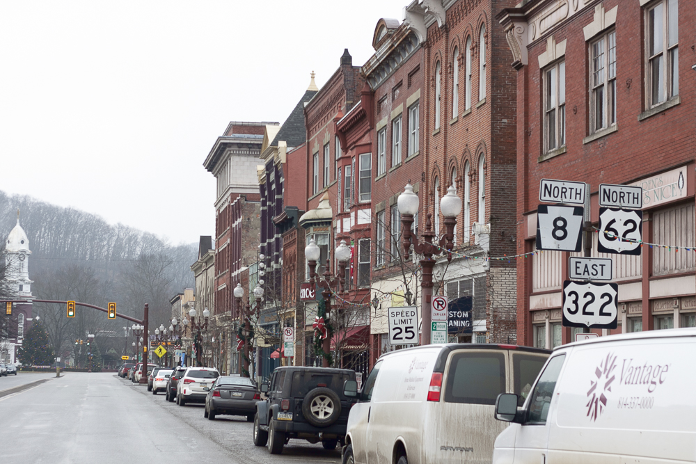


Franklin, Pennsylvania
Franklin is a city of 5,984 people in Venango County, Pennsylvania.
Why visit Franklin
Townapedia lists 7 museums and landmarks, 14 parks and trails, 22 places to eat, 1 place to stay and 4 attractions in and around town.
Highlights include Eighth Street Bridge, Barrow Civic Theater, Franklin Historic District and Indian God Rock.
July is the warmest month, with average highs of 83°F; January lows average 18°F, and about 54 inches of snow fall in a normal year.
Weather in Franklin
Forecast from the National Weather Service. Full forecast
About Franklin
Franklin is a city in and the county seat of Venango County, Pennsylvania, United States, located at the confluence of French Creek and the Allegheny River. The population was 6,077 in the 2020 census. Franklin is part of the Oil City micropolitan area. It is known for its three-day autumn festival in October, Applefest, which attracts hundreds of thousands of visitors.
From the Wikipedia article Franklin, Pennsylvania (this version), under CC BY-SA 4.0.
Things to do4

Eighth Street Bridge
Bridge · 0.8 mi
Bridge in Pennsylvania, United States



Museums and landmarks7

Franklin Historic District
Monument and historic site · National Register of Historic Places · 0.7 mi
Historic district in Franklin, Pennsylvania

Indian God Rock
Monument and historic site · National Register of Historic Places · 3.7 mi
Archaeological site in Rockland Township, United States of America


Samuel F. Dale House
Monument and historic site · National Register of Historic Places · 1.1 mi
Historic house in Franklin, Pennsylvania, United States

DeBence Antique Music World
Museum · 1.0 mi
1261 Liberty Street, Franklin
Parks, trails and playgrounds14


2 more on the map.
Restaurants and cafes22

Eat'n Park
Diner · American · 1.8 mi
533 Allegheny Boulevard, Franklin
Mo-Th 07:00-21:00; Fr-Sa 07:00-22:00; Su 07:00-21:00

Smoke Cantina
Restaurant · American, Tapas, Steak, International · 1.0 mi
1256 Liberty Street, Franklin



10 more on the map.
History
Franklin is located at the confluence of French Creek and the Allegheny River, an important site used for centuries by Native Americans. They had long before developed what became known as the Venango Path, passing from the head of French Creek north to Presque Isle Bay on Lake Erie. Via French Creek and the Allegheny River, the portage effectively linked the waterways of the Ohio River and the Great Lakes.
In 1740, Scottish fur trader John Fraser built a trading post here at Venango, the Lenape village. The French also had designs on this region.
They wanted to link their colonies of New France (Quebec) north of the Great Lakes, in Illinois Country (accessible via the Ohio River), and La Louisiane, on the lower Mississippi River. As tensions increased between France and Great Britain prior to the onset of the French and Indian War (as the North American front of the Seven Years' War was called), the French constructed four forts to control their continued access to the Venango Path and these important waterways. From north to south they were Fort Presque Isle, Fort Le Boeuf (at the south end of the portage and head of French Creek), Fort Machault, and Fort Duquesne, at the Forks of the Ohio.
From the History section of Franklin, Pennsylvania on Wikipedia, under CC BY-SA 4.0.
Where to stay1
Churches and places of worship17
Shopping8
Gas and EV charging4
Schools, colleges and libraries9
Healthcare1
Map of Franklin
87 places. The map loads OpenStreetMap tiles when you open it.
Climate by month
Monthly table
| Month | High | Low | Rain | Snow |
|---|---|---|---|---|
| Jan | 34°F | 18°F | 3.3 in | 17.9 in |
| Feb | 36°F | 19°F | 2.7 in | 11.5 in |
| Mar | 46°F | 25°F | 3.4 in | 8.9 in |
| Apr | 60°F | 35°F | 4.2 in | 1.1 in |
| May | 71°F | 46°F | 4.0 in | 0.0 in |
| Jun | 79°F | 56°F | 4.9 in | 0.0 in |
| Jul | 83°F | 60°F | 5.3 in | 0.0 in |
| Aug | 81°F | 58°F | 4.2 in | 0.0 in |
| Sep | 74°F | 52°F | 3.9 in | 0.0 in |
| Oct | 61°F | 41°F | 3.8 in | 0.0 in |
| Nov | 49°F | 32°F | 3.4 in | 2.6 in |
| Dec | 38°F | 24°F | 3.4 in | 11.7 in |
U.S. Climate Normals 1991-2020 for Franklin Hcn (1 mi away), NOAA NCEI.
People and cost of living
American Community Survey 5-year estimates, 2020-2024, U.S. Census Bureau. Estimates have margins of error, larger for small towns.
Disaster history
Venango County has had 8 federal disaster declarations since 2000, most often for severe storms.
- 2020-03-30: Covid-19 Pandemic (Biological)
- 2020-03-13: Covid-19 (Biological)
- 2013-10-01: Severe Storms, Tornadoes, And Flooding (Severe Storm)
- 2012-10-29: Hurricane Sandy (Hurricane)
- 2005-09-10: Hurricane Katrina (Hurricane)
- 2004-09-19: Tropical Depression Ivan (Hurricane)
OpenFEMA disaster declarations summaries.
Getting there and nearby towns
Venango Regional Airport KFKL (FKL) is the nearest airport with scheduled flights listed in OpenStreetMap, 1 miles away.
- Seneca 7 mi east, about 11 min by car
- Woodland Heights 7 mi east, about 11 min by car
- Hasson Heights 9 mi northeast, about 15 min by car
- Knox 19 mi southeast, about 30 min by car
- Marianne 23 mi southeast, about 37 min by car
- Meadville 25 mi northwest, about 39 min by car
- Clarion 26 mi southeast, about 42 min by car
- Conneaut Lakeshore 30 mi northwest, about 48 min by car
- Cambridge Springs 31 mi north, about 50 min by car
- Hermitage 33 mi west, about 54 min by car
Drive times are estimates from straight-line distance, not routes.
Local news
Headlines from INDB, the NEMICO news database.
Reviews, tips and questions
Loading what members have shared...
Sources and licences
- NCES EDGE (Public domain): public schools
- NOAA NCEI U.S. Climate Normals 1991-2020 (Public domain): climate by month
- OpenFEMA (Public domain): disaster declarations
- OpenStreetMap contributors (ODbL 1.0): places, airports, map data
- U.S. Census Bureau (Public domain): population, income, housing, education, commute
- Wikidata (CC0 1.0): elevation, founding date, time zone, website, landmarks and historic places
- Wikimedia Commons (see each image): photos
- Wikipedia (CC BY-SA 4.0): overview and history text
Photo credits
- Google Submission - Franklin-1, Zrudisin, CC BY-SA 4.0
- Allegheny River downstream from US 322 bridge in Franklin, PA, June 2024, Mr. Matté (if there is an issue with this image, contact me using this image's Commons talk page , my Commons user talk page , or my English Wikipedia user talk page ; I'll know about it a lot faster), CC BY-SA 4.0
- Franklin, Pennsylvania (4092593840), Doug Kerr from Albany, NY, United States, CC BY-SA 2.0
- US 62-PA 8 nb at Liberty Street, Franklin, June 2024, Mr. Matté (if there is an issue with this image, contact me using this image's Commons talk page , my Commons user talk page , or my English Wikipedia user talk page ; I'll know about it a lot faster), CC BY-SA 4.0
- Franklin, Pennsylvania (4092594426), Doug Kerr from Albany, NY, United States, CC BY-SA 2.0
- Franklin, Pennsylvania (4883464341), Doug Kerr from Albany, NY, United States, CC BY-SA 2.0
- Franklin, Pennsylvania (4092593390), Doug Kerr from Albany, NY, United States, CC BY-SA 2.0
- Franklin, Pennsylvania (4091829777), Doug Kerr from Albany, NY, United States, CC BY-SA 2.0
- First United Methodist Church (Franklin, Pennsylvania) (03), Doug Kerr from Albany, NY, United States, CC BY-SA 2.0
- Franklin, Pennsylvania (4883464117), Doug Kerr from Albany, NY, United States, CC BY-SA 2.0
- Franklin, Pennsylvania (4092593292), Doug Kerr from Albany, NY, United States, CC BY-SA 2.0
- Franklin, Pennsylvania (4092593742), Doug Kerr from Albany, NY, United States, CC BY-SA 2.0
- Franklin, Pennsylvania (4091829899), Doug Kerr from Albany, NY, United States, CC BY-SA 2.0
- Franklin, Pennsylvania (4884067726), Doug Kerr from Albany, NY, United States, CC BY-SA 2.0
- Franklin, Pennsylvania (4884066960), Doug Kerr from Albany, NY, United States, CC BY-SA 2.0
- Franklin, Pennsylvania (4092593166), Doug Kerr from Albany, NY, United States, CC BY-SA 2.0
- Franklin, Pennsylvania (4092593646), Doug Kerr from Albany, NY, United States, CC BY-SA 2.0
- Franklin, Pennsylvania (4091829325), Doug Kerr from Albany, NY, United States, CC BY-SA 2.0
- Indian God Rock, Melissa N. Hayes-Gehrke, CC BY 3.0
- Samuel F Dale House, Finetooth, CC BY-SA 3.0
- Earle's Mint-O-Mag, Nosferattus, CC0
- Time - Flickr - davetrainer, David Trainer from Mosteiros, Cape Verde, CC BY-SA 2.0
- Bluffs along US 322 in Cranberry Twp., Venango Co., PA, June 2024, Mr. Matté (if there is an issue with this image, contact me using this image's Commons talk page , my Commons user talk page , or my English Wikipedia user talk page ; I'll know about it a lot faster), CC BY-SA 4.0
- US 62-PA 8 nb at US 322 eb split, June 2024, Mr. Matté (if there is an issue with this image, contact me using this image's Commons talk page , my Commons user talk page , or my English Wikipedia user talk page ; I'll know about it a lot faster), CC BY-SA 4.0
- US 62-PA 8 nb approaching US 322 eb split, June 2024, Mr. Matté (if there is an issue with this image, contact me using this image's Commons talk page , my Commons user talk page , or my English Wikipedia user talk page ; I'll know about it a lot faster), CC BY-SA 4.0
- US 62 nb at PA 8 sb, June 2024, Mr. Matté (if there is an issue with this image, contact me using this image's Commons talk page , my Commons user talk page , or my English Wikipedia user talk page ; I'll know about it a lot faster), CC BY-SA 4.0
- Pyrite with Calcite (47753095371), Pacific Museum of Earth from Canada, CC BY-SA 2.0
- Venango County Courthouse, Calvin Beale, Public domain
- Pennsylvania State Route 8 - 4164570360, Dougtone, CC BY-SA 2.0
- N93905, Designism, CC0
- N2466P, Designism, CC0
- N750AD, Designism, CC0
- N97ZZ (2), Designism, CC0
- N97ZZ (1), Designism, CC0
- Venturi tube on C140, Designism, CC0
- N468MK, Designism, CC0
- A C140 in 2025 Venango Regional Airport wings and wheels, Designism, CC0
- N449BA loading people, Designism, CC0
- N449BA landing during 2025 Venango Wings and Wheels, Designism, CC0
- Beach City Baby C-53 during 2025 Venango Wings and Wheels, Designism, CC0


Page built October 30, 2026. Spotted a mistake? Tell us or suggest a place.