
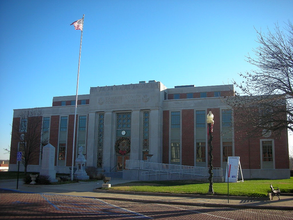


Fulton, Missouri
Fulton is a city of 12,617 people in Callaway County, Missouri, founded in 1825.
Why visit Fulton
Townapedia lists 21 museums and landmarks, 8 parks and trails, 7 places to eat, 4 places to stay and 4 attractions in and around town.
Highlights include B&B Fulton Cinema, Westminster College, Brandon-Bell-Collier House and Tanglewood Golf Course.
July is the warmest month, with average highs of 86°F; January lows average 20°F.
Weather in Fulton
Forecast from the National Weather Service. Full forecast
About Fulton
Fulton is the largest city in and the county seat of Callaway County, Missouri, United States. Located about 22 miles (35 km) northeast of Jefferson City and the Missouri River and 20 miles (32 km) east of Columbia, the city is part of the Jefferson City, Missouri, Metropolitan Statistical Area. The population was 12,600 at the 2020 census. The city is home to two universities, Westminster College and William Woods University; the Missouri School for the Deaf; the Fulton State Hospital; and the Fulton Reception and Diagnostic Center state prison.
From the Wikipedia article Fulton, Missouri (this version), under CC BY-SA 4.0.
Things to do4

Museums and landmarks21

Westminster College
Monument and historic site · National Register of Historic Places · 0.5 mi
Private college in Fulton, Missouri

Brandon-Bell-Collier House
Monument and historic site · National Register of Historic Places
Fulton, listed on the NRHP in Missouri

Court Street Historic Residential District
Monument and historic site · National Register of Historic Places
Historic district in Missouri, United States

Downtown Fulton Historic District
Monument and historic site · National Register of Historic Places · 0.5 mi
Historic district in Missouri, United States

Dr. George M. Willing House
Monument and historic site · National Register of Historic Places · 0.7 mi
Building in Missouri, United States

George Washington Carver School
Monument and historic site · National Register of Historic Places
School building in Fulton, Missouri

John Augustus Hockaday House
Monument and historic site · National Register of Historic Places · 0.9 mi
Building in Missouri, United States

M. Fred Bell Rental Cottage
Monument and historic site · National Register of Historic Places · 0.7 mi
Historic home located at Fulton, Missouri

M. Fred Bell Speculative Cottage
Monument and historic site · National Register of Historic Places · 0.7 mi
Historic house in Missouri, United States

National Churchill Museum
Monument and historic site · National Register of Historic Places · 0.4 mi
Museum in USA

Robnett-Payne House
Monument and historic site · National Register of Historic Places · 0.6 mi
Building in Missouri, United States

Westminster College Gymnasium
Monument and historic site · National Register of Historic Places · 0.6 mi
9 more on the map.
Parks, trails and playgrounds8





Restaurants and cafes7

Dragon Kitchen
Restaurant · Chinese · 0.8 mi
1893 North Bluff Street, Fulton
Tu-Su 10:30-21:30
Fulton Diner
Restaurant · 1.1 mi
2101 North Bluff Street
Mo-Su 06:00-15:00
MoJo's BBQ and Grill
Restaurant · Barbecue · 1.5 mi
2207 Cardinal Drive, Fulton
Mo-Sa 10:00-19:00

History
Fulton was founded and became the seat of Callaway County in 1825, although it would not be incorporated until March 14, 1859. At its founding, the city was named Volney after Constantin François de Chassebœuf, comte de Volney, but two months later renamed itself to honor engineer and inventor Robert Fulton. (There is a town in Oswego County, New York, named Volney after the Frenchman; it contains the village of Fulton, also named for the inventor.)
The early residents of Fulton were from predominantly southern culture. The coastal and upland southerners that settled the land brought with them enslaved people and established an agricultural economy.
From the History section of Fulton, Missouri on Wikipedia, under CC BY-SA 4.0.
Where to stay4
Churches and places of worship3
Shopping2
Gas and EV charging2
Schools, colleges and libraries24
Healthcare5
Map of Fulton
80 places. The map loads OpenStreetMap tiles when you open it.
Climate by month
Monthly table
| Month | High | Low | Rain | Snow |
|---|---|---|---|---|
| Jan | 37°F | 20°F | 2.4 in | 7.2 in |
| Feb | 42°F | 24°F | 2.2 in | 4.3 in |
| Mar | 53°F | 33°F | 3.1 in | 1.5 in |
| Apr | 64°F | 43°F | 4.8 in | 0.3 in |
| May | 73°F | 53°F | 5.2 in | 0.0 in |
| Jun | 82°F | 62°F | 4.5 in | 0.0 in |
| Jul | 86°F | 66°F | 4.5 in | 0.0 in |
| Aug | 85°F | 64°F | 4.0 in | 0.0 in |
| Sep | 78°F | 56°F | 4.2 in | 0.0 in |
| Oct | 66°F | 44°F | 3.7 in | 0.0 in |
| Nov | 53°F | 33°F | 3.1 in | 0.7 in |
| Dec | 41°F | 24°F | 2.5 in | 4.9 in |
U.S. Climate Normals 1991-2020 for Fulton (1 mi away), NOAA NCEI.
People and cost of living
American Community Survey 5-year estimates, 2020-2024, U.S. Census Bureau. Estimates have margins of error, larger for small towns.
Disaster history
Callaway County has had 21 federal disaster declarations since 2000, most often for severe storms.
- 2026-08-03: Severe Storms, Straight-Line Winds, Tornadoes, And Flooding (Severe Storm)
- 2025-05-21: Severe Storms, Straight-Line Winds, Tornadoes, And Wildfires (Severe Storm)
- 2021-09-01: Severe Storms, Straight-Line Winds, Tornadoes, And Flooding (Severe Storm)
- 2020-03-26: Covid-19 Pandemic (Biological)
- 2020-03-13: Covid-19 (Biological)
- 2019-07-09: Severe Storms, Tornadoes, And Flooding (Severe Storm)
OpenFEMA disaster declarations summaries.
Getting there and nearby towns
Columbia Regional Airport (COU) is the nearest airport with scheduled flights listed in OpenStreetMap, 15 miles away.
- Auxvasse 12 mi north, about 19 min by car
- New Bloomfield 12 mi southwest, about 20 min by car
- Ashland 16 mi west, about 25 min by car
- Chamois 16 mi southeast, about 25 min by car
- Tebbetts 16 mi south, about 26 min by car
- Holts Summit 17 mi southwest, about 27 min by car
- Columbia 21 mi west, about 34 min by car
- Mexico 22 mi north, about 35 min by car
- Jefferson City 23 mi southwest, about 37 min by car
- Hallsville 24 mi northwest, about 38 min by car
Drive times are estimates from straight-line distance, not routes.
Local news
Headlines from INDB, the NEMICO news database.
Reviews, tips and questions
Loading what members have shared...
Sources and licences
- NCES EDGE (Public domain): public schools
- NOAA NCEI U.S. Climate Normals 1991-2020 (Public domain): climate by month
- OpenFEMA (Public domain): disaster declarations
- OpenStreetMap contributors (ODbL 1.0): places, airports, map data
- U.S. Census Bureau (Public domain): population, income, housing, education, commute
- Wikidata (CC0 1.0): elevation, founding date, time zone, website, landmarks and historic places
- Wikimedia Commons (see each image): photos
- Wikipedia (CC BY-SA 4.0): overview and history text
Photo credits
- Fulton County Missouri Courthouse 01, Onegentlemanofverona, CC BY-SA 3.0
- Westminster Hall on Westminster College Campus, Fulton MO, Westminster College, Fulton MO, CC BY-SA 3.0
- G. W. Carver School (Fulton, MO) from SW 2, Ammodramus, CC0
- Brandon-Bell-Collier house from SE 2, Ammodramus, CC0
- Hockaday house (Fulton, MO) from NE 1, Ammodramus, CC0
- Willing & Dorsey General Store 405 Court St, Jim Roberts, CC BY-SA 4.0
- National Churchill Museum from S 1, Ammodramus, CC0
- Fulton, Missouri 304 E 5th St from NE 1, Ammodramus, CC0
- Fulton, Missouri 302 E 5th St from NE 1, Ammodramus, CC0
- George M. Willing house (Fulton, MO) from E 1, Ammodramus, CC0
- Robnett-Payne house (Fulton, MO) from S 2, Ammodramus, CC0
- John P. Newcomer House 7 East 9th. Street, Jim Roberts, CC BY-SA 4.0
- Westminster College gym from E 1, Ammodramus, CC0
Page built October 30, 2026. Spotted a mistake? Tell us or suggest a place.