


Gadsden, Alabama
Gadsden is a city of 33,374 people in Etowah County, Alabama, founded in February 18, 1867.
Why visit Gadsden
Townapedia lists 21 museums and landmarks, 18 parks and trails, 89 places to eat, 16 places to stay and 8 attractions in and around town.
Highlights include Mort Glosser Amphitheater, Gilliland-Reese Covered Bridge, Forrest Cemetery Chapel and Comfort Station and Alabama City Wall Street Historic District.
July is the warmest month, with average highs of 91°F; January lows average 33°F.
Weather in Gadsden
Forecast from the National Weather Service. Full forecast
About Gadsden
Gadsden is a city in and the county seat of Etowah County, Alabama, United States. The population was 33,945 as of the 2020 census, and was estimated at 33,367 in 2025, making it is the eighteenth-largest city in Alabama.
From the Wikipedia article Gadsden, Alabama (this version), under CC BY-SA 4.0.
Things to do8

Mort Glosser Amphitheater
Cinema and theater · National Register of Historic Places · 0.8 mi
Open-air theatre in Gadsden, Alabama, United States

Gilliland-Reese Covered Bridge
Bridge · 2.3 mi
Bridge in Gadsden, Alabama

Noccalula Falls Park
Waterfall · 2.4 mi
Park located in Gadsden, Alabama, United States



Museums and landmarks21

Forrest Cemetery Chapel and Comfort Station
Monument and historic site · National Register of Historic Places · 0.7 mi
Historic site in Etowah County, Alabama

Alabama City Wall Street Historic District
Monument and historic site · National Register of Historic Places · 1.9 mi
Historic district in Gadsden, Alabama, USA

Attalla Downtown Historic District
Monument and historic site · National Register of Historic Places · 4.3 mi
Historic district in Alabama, United States

Charles Gunn House
Monument and historic site · National Register of Historic Places · 0.5 mi
Historic house in Alabama, United States

Colonel O.R. Hood House
Monument and historic site · National Register of Historic Places · 0.5 mi
Historic house in Alabama, United States

Eleventh Street School
Monument and historic site · National Register of Historic Places · 0.5 mi
Historic school building in Gadsden, Alabama, USA

Gadsden Coca-Cola Bottling Plant
Monument and historic site · National Register of Historic Places · 0.5 mi
Historic building in Gadsden, Alabama, U.S.
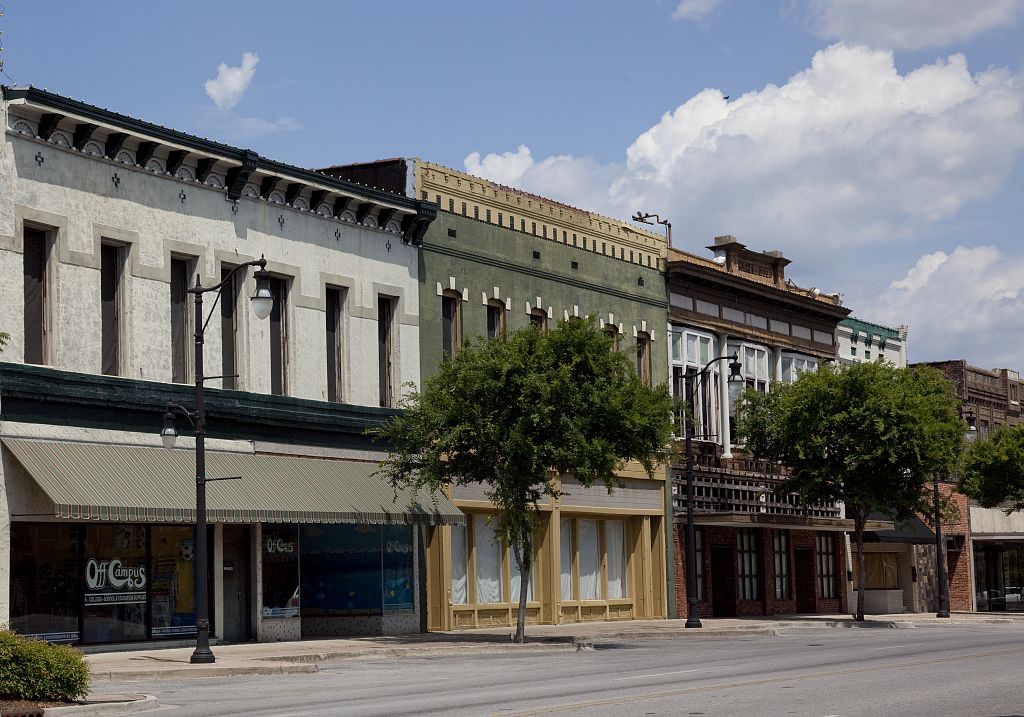
Gadsden Downtown Historic District
Monument and historic site · National Register of Historic Places · 0.8 mi
Historic district in Gadsden, Alabama

Gadsden Times-News Building
Monument and historic site · National Register of Historic Places · 0.8 mi
Historic building in Alabama, US

Howard Gardner Nichols Memorial Library
Monument and historic site · National Register of Historic Places · 2.1 mi
Historic building in Gadsden, Alabama, United States
Noojin House and Bellevue-Mineral Springs Hotel Site
Monument and historic site · National Register of Historic Places · 1.7 mi
Historic district in Gadsden, Alabama, United States


Turrentine Historic District
Monument and historic site · National Register of Historic Places
Historic district in Alabama, United States
9 more on the map.
Parks, trails and playgrounds18

Noccalula Falls Park
Park · 2.1 mi
1500 Noccalula Road, Gadsen
Feb 16-Apr 05 Mo-Th 09:00-17:00, Fr-Su 09:00-15:00


6 more on the map.
Restaurants and cafes89

Applebee's
Diner · American · 1.9 mi
1722 Rainbow Drive, Gadsden
Mo-Th 11:00-23:00; Fr-Sa 11:00-24:00; Su 11:00-22:00

Scooter's Coffee
Cafe · Coffee Shop · 3.9 mi
111 Church Street, Rainbow City
Mo-Th 05:00-20:30; Fr 05:00-21:00; Sa 06:00-21:00; Su 06:00-20:30



Chili's
Restaurant · Tex-Mex · 0.8 mi
340 North Albert Rains Boulevard, Gadsden
Mo-Th 10:30-23:00; Fr-Sa 10:30-24:00; Su 10:30-22:00
Popeye's Famous Fried Chicken
Restaurant · Chicken · 3.6 mi
3341 Rainbow Drive, Rainbow City
06:30-23:00
77 more on the map.
History
The first substantial European-American settlement in the area that developed as Gadsden was a village called "Double Springs". It was founded in about 1825 by John Riley, a mixed-race American Indian and European-American settler who built his house near two springs. Riley used his house for a stagecoach stop on the Huntsville-to-Rome route. The original building still stands as the oldest in Gadsden.
The house was purchased by brothers Gabriel and Asenath Hughes in 1840. The Hughes brothers purchased much of the land between Lookout Mountain, the Coosa River, and the mouth of Wills Creek. The brothers proposed constructing a railroad from the port of Savannah to Nashville, Tennessee through their land. The original 120 acres (49 ha) survey of Gadsden included the Hughes brothers' land, plus that of John S. Moragne and Lewis L. Rhea.
On July 4, 1845, Captain James Lafferty piloted the steamboat Coosa to the settlement. He landed near the site where the Memorial Bridge was built. The Hughes brothers suggested renaming the town as "Lafferty's Landing", but residents adopted "Gadsden" in honor of Colonel James Gadsden of South Carolina. He later was noted for negotiating the United States' Gadsden Purchase from Mexico.
From the History section of Gadsden, Alabama on Wikipedia, under CC BY-SA 4.0.
Where to stay16
Churches and places of worship162
Shopping18
Gas and EV charging19
Schools, colleges and libraries60
Attalla - Etowah County Public Library
Library · 4.3 mi
604 4th Street Northwest, Attalla
Etowah County Special Education Learning Center
School · 0.9 mi
401 Broad Street, Gadsden
Gadsden - Etowah County Public - East Gadsden Branch
Library · 1.8 mi
809 East Broad Street, Gadsden
Healthcare9
Map of Gadsden
250 places. The map loads OpenStreetMap tiles when you open it.
Climate by month
Monthly table
| Month | High | Low | Rain | Snow |
|---|---|---|---|---|
| Jan | 53°F | 33°F | 5.7 in | 0.0 in |
| Feb | 57°F | 36°F | 5.2 in | 0.1 in |
| Mar | 66°F | 43°F | 5.4 in | 0.0 in |
| Apr | 75°F | 50°F | 5.1 in | 0.0 in |
| May | 82°F | 59°F | 4.8 in | 0.0 in |
| Jun | 88°F | 68°F | 4.6 in | 0.0 in |
| Jul | 91°F | 71°F | 4.7 in | 0.0 in |
| Aug | 90°F | 70°F | 4.5 in | 0.0 in |
| Sep | 85°F | 64°F | 4.5 in | 0.0 in |
| Oct | 75°F | 52°F | 3.5 in | 0.0 in |
| Nov | 64°F | 41°F | 4.2 in | 0.0 in |
| Dec | 56°F | 36°F | 5.5 in | 0.1 in |
U.S. Climate Normals 1991-2020 for Gadsden (2 mi away), NOAA NCEI.
People and cost of living
American Community Survey 5-year estimates, 2020-2024, U.S. Census Bureau. Estimates have margins of error, larger for small towns.
Disaster history
Etowah County has had 18 federal disaster declarations since 2000, most often for severe storms.
- 2024-09-26: Hurricane Helene (Hurricane)
- 2020-09-14: Hurricane Sally (Hurricane)
- 2020-07-10: Severe Thunderstorms (Severe Storm)
- 2020-03-29: Covid-19 Pandemic (Biological)
- 2020-03-13: Covid-19 (Biological)
- 2018-04-26: Severe Storms And Tornadoes (Severe Storm)
OpenFEMA disaster declarations summaries.
Getting there and nearby towns
Northeast Alabama Regional Airport (GAD) is the nearest airport with scheduled flights listed in OpenStreetMap, 5 miles away.
- Rainbow City 7 mi southwest, about 11 min by car
- Boaz 15 mi northwest, about 25 min by car
- Jacksonville 20 mi southeast, about 33 min by car
- Albertville 21 mi northwest, about 34 min by car
- Saks 22 mi southeast, about 36 min by car
- Anniston 26 mi southeast, about 42 min by car
- Oxford 30 mi south, about 48 min by car
- Pell City 34 mi southwest, about 55 min by car
- Fort Payne 36 mi northeast, about 58 min by car
- Trussville 40 mi southwest, about 1 h by car
Drive times are estimates from straight-line distance, not routes.
Local news
Headlines from INDB, the NEMICO news database.
Reviews, tips and questions
Loading what members have shared...
Sources and licences
- NCES EDGE (Public domain): public schools
- NOAA NCEI U.S. Climate Normals 1991-2020 (Public domain): climate by month
- OpenFEMA (Public domain): disaster declarations
- OpenStreetMap contributors (ODbL 1.0): places, airports, map data
- U.S. Census Bureau (Public domain): population, income, housing, education, commute
- Wikidata (CC0 1.0): elevation, founding date, time zone, website, landmarks and historic places
- Wikimedia Commons (see each image): photos
- Wikipedia (CC BY-SA 4.0): overview and history text
Photo credits
- GadsdenAL Aerial, Curtis Palmer from Vestavia Hills (Birmingham), Alabama, USA, CC BY 2.0
- Coca-Cola Bottling Plant, Gadsden, AL, US, Bubba73, CC BY-SA 4.0
- Charles Gunn House, Gadsden, AL, US, Bubba73, CC BY-SA 4.0
- O.R. Hood House, Gadsden, AL, US, Bubba73, CC BY-SA 4.0
- Gadsden Times-News building, Gadsden, AL, US, Bubba73, CC BY-SA 4.0
- Premiere Cinemas GadsdenAL, Preston Rhea from Washington, DC, USA, CC BY-SA 2.0
- Gadsden Alabama City Hall, Waspleg, CC0
- Coosa Bridge Gadsden (Alabama), Aparna from Ann Arbor, MI, CC BY-SA 2.0
- Noojin House, Gadsden, AL, US, Bubba73, CC BY-SA 4.0
- Noccalula Falls Park in Gadsden, Alabama during the annual Christmas at the Falls light show 04, Harrison Keely, CC BY 4.0
- Noccalula Falls Park in Gadsden, Alabama during the annual Christmas at the Falls light show 03, Harrison Keely, CC BY 4.0
- Noccalula Falls Park in Gadsden, Alabama during the annual Christmas at the Falls light show 05, Harrison Keely, CC BY 4.0
- Noccalula Falls Park in Gadsden, Alabama during the annual Christmas at the Falls light show 01, Harrison Keely, CC BY 4.0
- Forrest Cemetery Chapel Oct 2014 1, Chris Pruitt, CC BY-SA 4.0
- Mort Glosser Amphitheater by Highsmith, Carol M. Highsmith, Public domain
- AttallaAlabamaPostOffice, DwayneP, CC BY-SA 3.0
- Hoyt Warsham Alabama City Branch library Oct 2014 1, Chris Pruitt, CC BY-SA 4.0
- Howard Gardner Nichols Memorial Library Oct 2014 1, Chris Pruitt, CC BY-SA 4.0
- 505 Turrentine Avenue Oct 2014, Chris Pruitt, CC BY-SA 4.0
- Bank of Attalla Oct 2014, Chris Pruitt, CC BY-SA 4.0
- Gadsden Alabama Federal Building by Highsmith, Carol M. Highsmith, Public domain
- Colonel O.R. Hood House Oct 2014 2, Chris Pruitt, CC BY-SA 4.0
- 435-425 Broad Street, Gadsden, Alabama by Highsmith, Carol M. Highsmith, Public domain
- Gadsden Times-News Building by Highsmith, Carol M. Highsmith, Public domain
- Eleventh Street School Gadsden Oct 2014 3, Chris Pruitt, CC BY-SA 4.0
- Charles Gunn House Oct 2014 3, Chris Pruitt, CC BY-SA 4.0
- Etowah County, Alabama Courthouse, Rivers Langley; SaveRivers, CC BY-SA 3.0
- Trenton Garmon regarding Mass Incarceration, DavidFreeman33AD, CC0
- Spirit of American Citizenship Monument, BullDawg2021, CC BY 4.0
- ISS049-E-49023 - View of Earth, Earth Science and Remote Sensing Unit , Lyndon B. Johnson Space Center, Public domain
- ISS043-E-184808 - View of Earth, Earth Science and Remote Sensing Unit , Lyndon B. Johnson Space Center, Public domain
- ISS043-E-184807 - View of Earth, Earth Science and Remote Sensing Unit , Lyndon B. Johnson Space Center, Public domain
- ISS061-E-21563 - View of Earth, Earth Science and Remote Sensing Unit, NASA Johnson Space Center, Public domain
- ISS049-E-49022 - View of Earth, Earth Science and Remote Sensing Unit , Lyndon B. Johnson Space Center, Public domain
- ISS056-E-37588 - View of Earth, Earth Science and Remote Sensing Unit, NASA Johnson Space Center, Public domain
- Forest Cemetary Chapel, Providence Ledbetter, CC BY-SA 3.0
- ISS049-E-49025 - View of Earth, Earth Science and Remote Sensing Unit , Lyndon B. Johnson Space Center, Public domain
- ISS049-E-49024 - View of Earth, Earth Science and Remote Sensing Unit , Lyndon B. Johnson Space Center, Public domain
- US411sRoad-US278ewUS431nsInt759signs (34346672714), formulanone from Huntsville, United States, CC BY-SA 2.0
- GRiD 2260 134650 Padenrich Ave - batteries, Josh Carlson, CC BY 2.0


Page built October 30, 2026. Spotted a mistake? Tell us or suggest a place.