


Garfield Heights, Ohio
Garfield Heights is a city of 29,269 people in Cuyahoga County, Ohio, founded in 1904.
Why visit Garfield Heights
Townapedia lists 13 museums and landmarks, 19 parks and trails, 67 places to eat, 2 places to stay and 6 attractions in and around town.
Highlights include Chancellor University, Musicarnival, Broadway Avenue Historic District and Broadway–Slavic Village.
July is the warmest month, with average highs of 81°F; January lows average 24°F.
Weather in Garfield Heights
Forecast from the National Weather Service. Full forecast
About Garfield Heights
Garfield Heights is a city in Cuyahoga County, Ohio, United States. The population was 29,781 at the time of the 2020 census. A suburb of Cleveland, it is a part of the Cleveland metropolitan area.
From the Wikipedia article Garfield Heights, Ohio (this version), under CC BY-SA 4.0.
Things to do6

Chancellor University
School · 3.2 mi
Former private university in Cleveland, Ohio

Musicarnival
Cinema and theater · 4.0 mi
A tent theater venue in the round

Valley View Bridge
Bridge · 1.6 mi
Bridge in United States of America


Museums and landmarks13

Broadway Avenue Historic District
Monument and historic site · National Register of Historic Places · 4.1 mi
Historic district in Cleveland, Ohio, USA

Broadway–Slavic Village
Monument and historic site · National Register of Historic Places · 3.4 mi
Historic neighborhood on the southeast side of Cleveland, Ohio
Edmund Gleason Farm
Monument and historic site · National Register of Historic Places · 3.6 mi
Building in Ohio, United States
St. Joseph Convent and Academy Complex
Monument and historic site · National Register of Historic Places · 0.4 mi
Historic church in Garfield Heights, Ohio, United States

Tinkers Creek Aqueduct
Monument and historic site · National Register of Historic Places · 3.7 mi
Bridge in United States of America
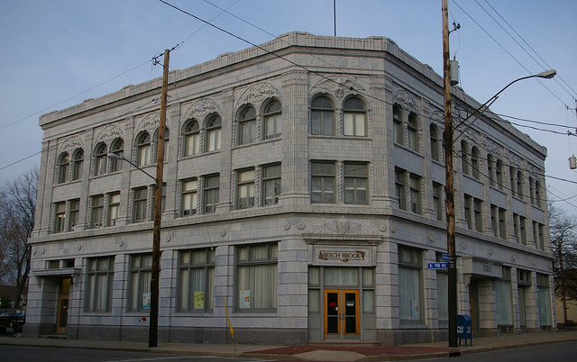
Weizer Building
Monument and historic site · National Register of Historic Places · 4.3 mi
Building in Ohio, United States of America

Wilson Feed Mill
Monument and historic site · National Register of Historic Places · 4.3 mi
Grist mill in Ohio

Hruby Conservatory of Music
Monument and historic site · National Register of Historic Places · 4.2 mi


Wade Park District
Monument and historic site · National Register of Historic Places · 3.9 mi
1 more on the map.
Parks, trails and playgrounds19


7 more on the map.
Restaurants and cafes67


L.A. Pete's
Restaurant · Breakfast · 2.3 mi
6080 Brecksville Road, Independence
Mo-Su 07:00-14:00
Yours Truly
Restaurant · Breakfast, Burger, Pancake · 2.1 mi
Mo-Th 06:30-21:00; Fr,Sa 06:30-22:00; Su 07:30-21:00

55 more on the map.
History
The area was originally part of Newburgh Township. The Village of South Newburgh was formed in 1907, changed its name to Garfield Hts Village in 1919 and it was incorporated as Garfield Heights in 1930 when the cities population hit 5000. The city is named after Garfield Park, which in turn was named in honor of President James A. Garfield, a native of nearby Orange Township.
From the History section of Garfield Heights, Ohio on Wikipedia, under CC BY-SA 4.0.
Where to stay2
Churches and places of worship50
Bedford Baptist Church
Church · National Register of Historic Places · 4.2 mi
Independence Presbyterian Church
Church · National Register of Historic Places · 3.2 mi
Shrine Church of St. Stanislaus
Church · National Register of Historic Places · 3.4 mi
New Joshua Missionary Baptist Church
Church · Baptist · 1.8 mi
11200 Miles Avenue, Cleveland
Saints Peter and Paul
Church · Roman Catholic · 1.0 mi
4750 Turney Road, Garfield Heights
Shopping13
Gas and EV charging15
Schools, colleges and libraries75
Alternative Education Academy
School · 3.1 mi
4 Summit Park Dr Ste 350, Independence
Healthcare10
Miles Broadway Health Center
Clinic and pharmacy · 2.1 mi
9127 Miles Avenue, Cleveland
Map of Garfield Heights
250 places. The map loads OpenStreetMap tiles when you open it.
Climate by month
Monthly table
| Month | High | Low | Rain |
|---|---|---|---|
| Jan | 35°F | 24°F | 1.8 in |
| Feb | 37°F | 24°F | 1.5 in |
| Mar | 45°F | 31°F | 2.4 in |
| Apr | 57°F | 41°F | 3.1 in |
| May | 68°F | 53°F | 3.5 in |
| Jun | 77°F | 63°F | 2.8 in |
| Jul | 81°F | 68°F | 3.7 in |
| Aug | 80°F | 67°F | 3.5 in |
| Sep | 74°F | 60°F | 2.9 in |
| Oct | 62°F | 49°F | 3.2 in |
| Nov | 50°F | 38°F | 2.9 in |
| Dec | 40°F | 30°F | 2.0 in |
U.S. Climate Normals 1991-2020 for Cleveland Burke Ap (8 mi away), NOAA NCEI.
People and cost of living
American Community Survey 5-year estimates, 2020-2024, U.S. Census Bureau. Estimates have margins of error, larger for small towns.
Disaster history
Cuyahoga County has had 11 federal disaster declarations since 2000, most often for severe storms.
- 2020-03-31: Covid-19 Pandemic (Biological)
- 2020-03-13: Covid-19 (Biological)
- 2013-01-03: Severe Storms And Flooding Due To The Remnants Of Hurricane Sandy (Hurricane)
- 2012-06-30: Severe Storms (Severe Storm)
- 2006-07-02: Severe Storms, Tornadoes, Straight Line Winds, And Flooding (Severe Storm)
- 2005-09-13: Hurricane Katrina Evacuation (Hurricane)
OpenFEMA disaster declarations summaries.
Getting there and nearby towns
Burke Lakefront Airport (BKL) is the nearest airport with scheduled flights listed in OpenStreetMap, 8 miles away.
- Maple Heights 2 mi east, about 4 min by car
- Bedford 4 mi southeast, about 7 min by car
- Warrensville Heights 5 mi east, about 7 min by car
- Seven Hills 5 mi southwest, about 7 min by car
- Shaker Heights 5 mi northeast, about 8 min by car
- Bedford Heights 5 mi east, about 9 min by car
- Cleveland 6 mi northwest, about 9 min by car
- University Heights 6 mi northeast, about 10 min by car
- Parma 7 mi west, about 11 min by car
- Cleveland Heights 7 mi north, about 11 min by car
Drive times are estimates from straight-line distance, not routes.
Local news
Headlines from INDB, the NEMICO news database.
Reviews, tips and questions
Loading what members have shared...
Sources and licences
- NCES EDGE (Public domain): public schools
- NOAA NCEI U.S. Climate Normals 1991-2020 (Public domain): climate by month
- OpenFEMA (Public domain): disaster declarations
- OpenStreetMap contributors (ODbL 1.0): places, airports, map data
- U.S. Census Bureau (Public domain): population, income, housing, education, commute
- Wikidata (CC0 1.0): elevation, founding date, time zone, website, landmarks and historic places
- Wikimedia Commons (see each image): photos
- Wikipedia (CC BY-SA 4.0): overview and history text
Photo credits
- Garfield Heights city hall, AJHalliwell at en.wikipedia, CC BY-SA 3.0
- Interstate 480 Bridge Garfield Heights, Eddie~S, CC BY 2.0
- St. Stanislaus, stu_spivack, CC BY-SA 2.0
- Bedford Ohio Baptist Church 1892, Christopher Busta-Peck ( Talk ), CC BY-SA 1.0
- Tinkers Creek Aqueduct (III), Momopanda4, CC BY-SA 3.0
- Edmond Gleeson House NPS, National Park Service, Public domain
- Alexander Mill (Canal Rd) Ohio & Erie Canal, Chris Light, CC BY-SA 4.0
- Signage 01 - Broadway Avenue Historic District (34200743404), Tim Evanson from Cleveland Heights, Ohio, USA, CC BY-SA 2.0
- Independence Presbyterian Church, Nyttend, Public domain
- Weizer11801Buckeye, Christopher Busta-Peck, CC BY-SA 3.0
- Cleveland Museum of Art - lagoon with statue, Daderot, Public domain
- Hruby Conservatory of Music, stu_spivack, CC BY-SA 2.0
- ValleyViewBridge, Pdcook, CC BY-SA 3.0
- St. Joseph Convent, now a hospital, Nyttend, Public domain
- LORAM LMIX-605 rail grinder 01, Tim Evanson, CC BY-SA 2.0
- LORAM LMIX-605 rail grinder 02, Tim Evanson, CC BY-SA 2.0
- LORAM LMIX-605 rail grinder 03, Tim Evanson, CC BY-SA 2.0
- Grave of Cleveland mob bosses Vincent and Joseph Porrello, Tim Evanson, CC BY-SA 2.0
- Grave of Vincent and Joseph Porrello, Tim Evanson, CC BY-SA 2.0
- Grave of stella walsh, Tim Evanson, CC BY-SA 2.0
- Grave of stella walsh 2, Tim Evanson, CC BY-SA 2.0
- Valley View, OH 44125, USA - panoramio, Eric Friedebach, CC BY 3.0
- ISS047-E-151135 - View of Earth, Earth Science and Remote Sensing Unit , Lyndon B. Johnson Space Center, Public domain
- Interstate 480 Bridge Ohio, Eddie~S, CC BY 2.0
- CarloWolff 2020, Ronhilltoon, CC BY-SA 4.0
- Movie palace (35184594961), Tim Evanson from Cleveland Heights, Ohio, USA, CC BY-SA 2.0
- Movie theater popcorn machine, Tim Evanson, CC BY-SA 2.0
- Grave of Cleveland mob boss Joseph Lonardo, Tim Evanson, CC BY-SA 2.0
- Bike Night at Quaker Stake 2003 - panoramio - EAydinceren, EAydinceren, CC BY 3.0
- Bike Night at Quaker Stake 2003 - panoramio, EAydinceren, CC BY 3.0
- Kaptur with Paul Labuda of Baker's Union (41894807675), Congresswoman Marcy Kaptur, CC BY 2.0
- Angelo Lonardo grave - Calvary Cemetery, Tim Evanson, CC BY-SA 2.0
- Maple Heights, OH, USA - panoramio, Eric Friedebach, CC BY 3.0
- Southern end of Vine Street, Maple Heights, Nyttend, Public domain
- Chevrolet Corvette Stingray (C8), Ghostofakina, CC BY-SA 4.0
- Cleveland Temple aux 2026, JonRidinger, CC BY-SA 4.0
- Cataract Falls (51658657944), Erik Drost, CC BY 2.0
- Cataract Falls (51658654909), Erik Drost, CC BY 2.0
- Cleveland Temple southwest, JonRidinger, CC BY-SA 4.0
- Cleveland Temple east 1, JonRidinger, CC BY-SA 4.0


Page built October 30, 2026. Spotted a mistake? Tell us or suggest a place.