


Why visit Genesee
Townapedia lists 12 museums and landmarks, 7 parks and trails, 6 places to eat and 6 attractions in and around town.
Highlights include Heritage Square, Red Rocks Amphitheatre, Evergreen Conference District and Genesee Park.
July is the warmest month, with average highs of 81°F; January lows average 12°F, and about 81 inches of snow fall in a normal year.
Weather in Genesee
Forecast from the National Weather Service. Full forecast
About Genesee
Genesee is an unincorporated community and a census-designated place (CDP) located in and governed by Jefferson County, Colorado, United States. The CDP is a part of the Denver–Aurora–Lakewood, CO Metropolitan Statistical Area. The population of the Genesee CDP was 3,610 at the United States Census 2020. The Golden post office (Zip code 80401) serves the area.
From the Wikipedia article Genesee, Colorado (this version), under CC BY-SA 4.0.
Things to do6

Heritage Square
Monument and historic site · 3.6 mi
Shopping village at Golden, Colorado
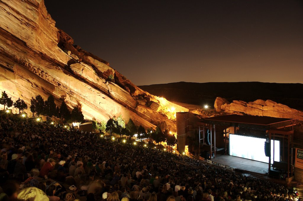
Red Rocks Amphitheatre
Cinema and theater · 3.8 mi
Concert venue near Morrison, Colorado, United States of America

Museums and landmarks12

Evergreen Conference District
Monument and historic site · National Register of Historic Places · 4.2 mi
Historic district in Colorado, United States

Genesee Park
Monument and historic site · National Register of Historic Places · 2.9 mi
First and largest of the Denver Mountain Parks

Hiwan Homestead Museum
Museum · National Register of Historic Places · 4.3 mi
Museum in Colorado, United States

Lookout Mountain Park
Monument and historic site · National Register of Historic Places · 3.5 mi
Historic district in Colorado, United States

Mother Cabrini Shrine
Monument and historic site · National Register of Historic Places · 2.5 mi
Religious shrine in Golden, Colorado
Rooney Ranch
Monument and historic site · National Register of Historic Places · 4.2 mi
Human settlement in United States of America
Sculptured House
Monument and historic site · National Register of Historic Places · 0.9 mi
House in Jefferson County, Colorado

Bear Creek Canyon Scenic Mountain Drive
Monument and historic site · National Register of Historic Places · 3.3 mi

Colorow Point Park
Monument and historic site · National Register of Historic Places · 3.1 mi

Parks, trails and playgrounds7

Katherine Craig Park
Park · National Register of Historic Places · 1.9 mi
Park in Jefferson County, Colorado, United States of America

Red Rocks Park
Park · National Register of Historic Places · 3.8 mi
Historic district in Jefferson County, Colorado, United States



Restaurants and cafes6

Buffalo Moon Coffee Shop Cafe & Gifts
Cafe · Coffee Shop · 1.9 mi
25948 Genesee Trail Road, Golden
Mo-Sa 07:00-14:00


Churches and places of worship2
Rockland Community Church and Cemetery
Church · National Register of Historic Places · 1.5 mi
Rockland Community Church
Church · 2.3 mi
17 South Mount Vernon Country Club Road, Golden
Shopping1
Schools, colleges and libraries17
Bergen Valley Intermediate School
School · 4.2 mi
1422 Sugarbush Drive, Evergreen
Connections Learning Center On The Earle Johnson C
School · 5.1 mi
1200 Johnson Road, Golden
Map of Genesee
51 places. The map loads OpenStreetMap tiles when you open it.
Climate by month
Monthly table
| Month | High | Low | Rain | Snow |
|---|---|---|---|---|
| Jan | 44°F | 12°F | 0.6 in | 8.8 in |
| Feb | 44°F | 13°F | 0.9 in | 11.4 in |
| Mar | 51°F | 21°F | 1.8 in | 17.0 in |
| Apr | 56°F | 27°F | 2.4 in | 14.9 in |
| May | 64°F | 36°F | 2.5 in | 2.7 in |
| Jun | 76°F | 43°F | 1.7 in | 0.0 in |
| Jul | 81°F | 49°F | 2.2 in | 0.0 in |
| Aug | 79°F | 47°F | 2.3 in | 0.0 in |
| Sep | 72°F | 40°F | 1.6 in | 1.1 in |
| Oct | 61°F | 29°F | 1.2 in | 6.5 in |
| Nov | 51°F | 20°F | 0.8 in | 10.4 in |
| Dec | 44°F | 13°F | 0.7 in | 8.0 in |
U.S. Climate Normals 1991-2020 for Evergreen (4 mi away), NOAA NCEI.
People and cost of living
American Community Survey 5-year estimates, 2020-2024, U.S. Census Bureau. Estimates have margins of error, larger for small towns.
Disaster history
Jefferson County has had 13 federal disaster declarations since 2000, most often for fires.
- 2024-08-01: Quarry Fire (Fire)
- 2023-08-25: Severe Storms, Flooding, And Tornadoes (Flood)
- 2020-03-28: Covid-19 Pandemic (Biological)
- 2020-03-13: Covid-19 (Biological)
- 2013-09-14: Severe Storms, Flooding, Landslides, And Mudslides (Flood)
- 2013-09-12: Severe Storms, Flooding, Landslides, And Mudslides (Flood)
OpenFEMA disaster declarations summaries.
Getting there and nearby towns
Rocky Mountain Metropolitan Airport (BJC) is the nearest airport with scheduled flights listed in OpenStreetMap, 17 miles away.
- Golden 5 mi northeast, about 8 min by car
- Evergreen 5 mi southwest, about 8 min by car
- West Pleasant View 6 mi northeast, about 9 min by car
- Applewood 7 mi northeast, about 11 min by car
- Lakewood 8 mi east, about 13 min by car
- Dakota Ridge 9 mi southeast, about 14 min by car
- Fairmount 9 mi northeast, about 14 min by car
- Wheat Ridge 11 mi northeast, about 17 min by car
- Ken Caryl 11 mi southeast, about 18 min by car
- Arvada 12 mi northeast, about 19 min by car
Drive times are estimates from straight-line distance, not routes.
Local news
Headlines from INDB, the NEMICO news database.
Reviews, tips and questions
Loading what members have shared...
Sources and licences
- NCES EDGE (Public domain): public schools
- NOAA NCEI U.S. Climate Normals 1991-2020 (Public domain): climate by month
- OpenFEMA (Public domain): disaster declarations
- OpenStreetMap contributors (ODbL 1.0): places, airports, map data
- U.S. Census Bureau (Public domain): population, income, housing, education, commute
- Wikidata (CC0 1.0): elevation, founding date, time zone, website, landmarks and historic places
- Wikimedia Commons (see each image): photos
- Wikipedia (CC BY-SA 4.0): overview and history text
Photo credits
- ChiefHosa, Ford Optical Company, Public domain
- 2022-09-11 10 08 32 View west along Interstate 70 from the overpass for Mount Vernon Country Club Road in Genesee Park, Jefferson County, Colorado, Famartin, CC BY-SA 4.0
- Hiwan Homestead, 25or6to4, CC BY-SA 3.0
- RooneyRanch, Paul M. Murillo, Public domain
- St. John's Episcopal Church in Evergreen, CO 1, Empresspht, CC BY-SA 4.0
- RedRocks, Hogs555, CC BY-SA 3.0
- Bison herd at Genesee Park-2012 03 10 0601, Postdlf, CC BY-SA 3.0
- Lookout Mountain Park Golden CO, Hustvedt, CC BY-SA 3.0
- Colorow Point Park, Jeffrey Beall, CC BY 3.0
- Bear Creek Canyon Scenic Mountain Drive, Jeffrey Beall, CC BY-SA 3.0
- RedRocksAMP, Unknown author, CC BY-SA 3.0
- Dinosaur Ridge tracks, Footwarrior, CC BY-SA 3.0
- Abandoned street, Heritage Square, Xnatedawgx, CC BY-SA 3.0
- Rosary Garden at Mother Cabrini Shrine in Denver Colorado, Always dreamin, CC BY-SA 4.0
- Sacred Heart of Jesus on top of the hill at Mother Cabrini Shrine in Denver Colorado 2, Always dreamin, CC BY-SA 4.0
- Vinh Le, a pilot with the US Forest Service, was presented with an award, on 2020-06-19, from Secretary Sonny Perdue (50035065797), Forest Service, USDA, Public domain
- Secretary Perdue and Senator Gardner in Denver Area (20200619-OSEC-LSC-0535), USDAgov, Public domain
- Secretary Perdue and Senator Gardner in Denver Area (20200619-OSEC-LSC-0544), USDAgov, Public domain
- VIPs inspect Forest Service water bomber on 2020-06-19 (50035063687), Forest Service, USDA, Public domain
- Stations of the Cross at Mother Cabrini Shrine Station 11, Always dreamin, CC BY-SA 4.0
- Stations of the Cross at Mother Cabrini Shrine Station 10, Always dreamin, CC BY-SA 4.0
- Stations of the Cross at Mother Cabrini Shrine Station 12, Always dreamin, CC BY-SA 4.0
- Stations of the Cross at Mother Cabrini Shrine Station 1, Always dreamin, CC BY-SA 4.0
- US-CO-Sculptured-House-03, DutchTreat, CC BY-SA 4.0
- US-CO-Sculptured-House-05, DutchTreat, CC BY-SA 4.0
- US-CO-Sculptured-House-01, DutchTreat, CC BY-SA 4.0
- US-CO-Sculptured-House-02, DutchTreat, CC BY-SA 4.0
- Rockland Community Church and Cemetery, Jeffrey Beall, CC BY-SA 3.0
- US-CO-Sculptured-House-04, DutchTreat, CC BY-SA 4.0
- ISS038-E-4379 - View of Earth, Earth Science and Remote Sensing Unit , Lyndon B. Johnson Space Center, Public domain
- ISS029-E-18112 - View of Earth, Earth Science and Remote Sensing Unit , Lyndon B. Johnson Space Center, Public domain
- ISS028-E-35915 - View of Nebraska, Earth Science and Remote Sensing Unit , Lyndon B. Johnson Space Center, Public domain
- ISS040-E-588 - View of Earth, Earth Science and Remote Sensing Unit , Lyndon B. Johnson Space Center, Public domain
- ISS038-E-4378 - View of Earth, Earth Science and Remote Sensing Unit , Lyndon B. Johnson Space Center, Public domain
- ISS028-E-35731 - View of Colorado, Earth Science and Remote Sensing Unit , Lyndon B. Johnson Space Center, Public domain
- ISS040-E-589 - View of Earth, Earth Science and Remote Sensing Unit , Lyndon B. Johnson Space Center, Public domain
- ISS038-E-48500 - View of Earth, Earth Science and Remote Sensing Unit , Lyndon B. Johnson Space Center, Public domain
- Katherine Craig Park, Jeffrey Beall, CC BY 3.0
- Colorado mountain range, Gzprice, CC BY 4.0
- Little Park Idledale CO, Hustvedt, CC BY-SA 3.0


Page built October 30, 2026. Spotted a mistake? Tell us or suggest a place.