


Globe, Arizona
Globe is a city of 7,195 people in Gila County, Arizona, founded in 1875.
Why visit Globe
Townapedia lists 11 museums and landmarks, 5 parks and trails, 17 places to eat, 10 places to stay and 5 attractions in and around town.
Highlights include Hollis Cinema 4, Besh-Ba-Gowah and Elks Building.
July is the warmest month, with average highs of 97°F; December lows average 33°F.
Weather in Globe
Forecast from the National Weather Service. Full forecast
About Globe
Globe (Western Apache: Bésh Baa Gowąh "Place of Metal") is a city in and the county seat of Gila County, Arizona, United States. As of the 2020 census, the population of the city was 7,249. Globe was founded c. 1875 as a mining camp.
From the Wikipedia article Globe, Arizona (this version), under CC BY-SA 4.0.
Things to do5


Museums and landmarks11

Besh-Ba-Gowah
Monument and historic site · National Register of Historic Places · 1.9 mi
Archaeological site in Arizona, United States

Elks Building
Cinema and theater · National Register of Historic Places · 2.1 mi
Theatre building in Arizona, United States of America

Gila County Courthouse
Monument and historic site · National Register of Historic Places · 2.6 mi
Courthouse in Globe, Arizona

Gila Valley Bank and Trust Building
Monument and historic site · National Register of Historic Places · 2.0 mi
Bank building in Globe, United States of America

Globe Downtown Historic District
Monument and historic site · National Register of Historic Places · 2.5 mi
Historic district in Arizona, United States

Globe Ranger Station
Monument and historic site · National Register of Historic Places · 2.0 mi
The principal office of the Globe Ranger District of the Tonto National Forest in Arizona
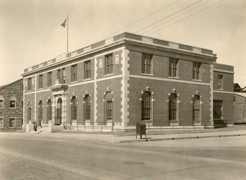


United States Post Office and Courthouse–Globe Main
Monument and historic site · National Register of Historic Places · 2.6 mi
Located in Globe, Arizona and was built in 1926

Besh Ba Gowah Archaeological Park and Museum
Monument and historic site · 2.0 mi
Parks, trails and playgrounds5

Restaurants and cafes17

Ed's La Casita East
Restaurant · Mexican · 1.2 mi
1960 East Ash Street, Globe



5 more on the map.
History
Besh-Ba-Gowah, about one mile south of Globe, was occupied by Salado populations between AD 1225 and AD 1400.
In 1875 silver was discovered in the San Carlos Apache Indian Reservation. Accordingly, that same year, the mining camp at Ramboz Peak nearest to the reservation relocated to what became Globe. The plans for an incorporated Globe were established in July 1876, with retail stores, banks, and Globe's first newspaper printing its first issue on May 2, 1878. By February 1881, Globe was the Gila County seat. Coming with Globe's new importance as the county seat came a stagecoach line linking it to Silver City, New Mexico.
Due to Globe's relative isolation from the rest of Arizona and its proximity to the San Carlos Apache reservation, Globe remained a frontier town. Globe's history is laced with many historic events such as murders, stagecoach robberies, outlaws, lynchings, and Apache raids. Natiotish, a San Carlos Apache, left the reservation with a group of about 50 men and continued to attack ranchers and miners.
In 1884 the surviving Clanton brothers Ike and Phineas arrived in Apache County after the infamous gunfight at the OK Corral in Tombstone. Ike was eventually killed by a local deputy sheriff, and Phineas, after serving prison time for a stage robbery, moved to Globe, where he died of pneumonia and was buried in 1906.
From the History section of Globe, Arizona on Wikipedia, under CC BY-SA 4.0.
Where to stay10
Churches and places of worship12
St. John's Episcopal Church
Church · Episcopal · National Register of Historic Places · 2.6 mi
185 East Oak Street, Globe
Holy Angels Church
Church · National Register of Historic Places · 2.6 mi
Holy Angels Roman Catholic Church
Church · Roman Catholic · 2.6 mi
231 South Broad Street, Globe
Shopping3
Gas and EV charging4
Schools, colleges and libraries18
Cvit - Central Campus Eac Gila Pueblo
School · 2.5 mi
1500 Panther Dr Bldg 3 Room, Superior
Dr. Charles A. Bejarano Elementary School
School · 5.5 mi
4635 B Ragus Road, Miami
Map of Globe
85 places. The map loads OpenStreetMap tiles when you open it.
Climate by month
Monthly table
| Month | High | Low | Rain |
|---|---|---|---|
| Jan | 55°F | 33°F | 2.0 in |
| Feb | 59°F | 36°F | 1.9 in |
| Mar | 68°F | 41°F | 1.0 in |
| Apr | 76°F | 47°F | 0.4 in |
| May | 85°F | 55°F | 0.3 in |
| Jun | 96°F | 64°F | 0.3 in |
| Jul | 97°F | 71°F | 2.7 in |
| Aug | 95°F | 69°F | 2.1 in |
| Sep | 90°F | 63°F | 1.0 in |
| Oct | 79°F | 52°F | 1.2 in |
| Nov | 65°F | 41°F | 1.1 in |
| Dec | 56°F | 33°F | 1.5 in |
U.S. Climate Normals 1991-2020 for Globe #3 (3 mi away), NOAA NCEI.
People and cost of living
American Community Survey 5-year estimates, 2020-2024, U.S. Census Bureau. Estimates have margins of error, larger for small towns.
Disaster history
Gila County has had 15 federal disaster declarations since 2000, most often for fires.
- 2021-06-06: Telegraph Fire (Fire)
- 2020-08-26: Griffin Fire (Fire)
- 2020-06-20: Bush Fire (Fire)
- 2020-04-04: Covid-19 Pandemic (Biological)
- 2020-03-13: Covid-19 (Biological)
- 2010-03-18: Severe Winter Storms And Flooding (Severe Storm)
OpenFEMA disaster declarations summaries.
Getting there and nearby towns
Wheeler Landing Field (historical) is the nearest airport with scheduled flights listed in OpenStreetMap, 3 miles away.
- Central Heights-Midland City 4 mi west, about 7 min by car
- Claypool 6 mi west, about 9 min by car
- Gold Canyon 39 mi west, about 1 h by car
- Florence 45 mi southwest, about 1 h 15 min by car
- Apache Junction 46 mi west, about 1 h 15 min by car
- San Tan Valley 48 mi west, about 1 h 15 min by car
- Canyon Day 48 mi northeast, about 1 h 15 min by car
- Queen Creek 51 mi west, about 1 h 30 min by car
- Blackwater 54 mi southwest, about 1 h 30 min by car
- Coolidge 55 mi southwest, about 1 h 30 min by car
Drive times are estimates from straight-line distance, not routes.
Local news
Headlines from INDB, the NEMICO news database.
Reviews, tips and questions
Loading what members have shared...
Sources and licences
- NCES EDGE (Public domain): public schools
- NOAA NCEI U.S. Climate Normals 1991-2020 (Public domain): climate by month
- OpenFEMA (Public domain): disaster declarations
- OpenStreetMap contributors (ODbL 1.0): places, airports, map data
- U.S. Census Bureau (Public domain): population, income, housing, education, commute
- Wikidata (CC0 1.0): elevation, founding date, time zone, website, landmarks and historic places
- Wikimedia Commons (see each image): photos
- Wikipedia (CC BY-SA 4.0): overview and history text
Photo credits
- Globe AZ - August 17, 2021 - (3 of 12) (51387939803), Xander Ashburn, CC BY 2.0
- Globe AZ - August 17, 2021 - (7 of 12) (51386934442), Xander Ashburn, CC BY 2.0
- Globe AZ - August 17, 2021 - (6 of 12) (51387941683), Xander Ashburn, CC BY 2.0
- Globe AZ - August 17, 2021 - (11 of 12) (51386933647), Xander Ashburn, CC BY 2.0
- Globe AZ - August 17, 2021 - (5 of 12) (51387941863), Xander Ashburn, CC BY 2.0
- Globe AZ - August 17, 2021 - (2 of 12) (51387940033), Xander Ashburn, CC BY 2.0
- Globe AZ - August 17, 2021 - (8 of 12) (51387941293), Xander Ashburn, CC BY 2.0
- Globe AZ - August 17, 2021 - (10 of 12) (51387940788), Xander Ashburn, CC BY 2.0
- Globe AZ - August 17, 2021 - (4 of 12) (51386935072), Xander Ashburn, CC BY 2.0
- Globe AZ - August 17, 2021 - (1 of 12) (51388700035), Xander Ashburn, CC BY 2.0
- Globe AZ - August 17, 2021 - (9 of 12) (51388700840), Xander Ashburn, CC BY 2.0
- Globe Valley National Bank, Panchitaville, CC BY-SA 3.0
- U.S. Route 60 Globe, AZ (24671201076), Mobilus In Mobili, CC BY-SA 2.0
- Southwest Corner Cedar & Broad streets, Globe, AZ, Eric Wincentsen, CC BY-SA 3.0
- Apache Crown Dancers Globe AZ, StellarD, CC BY-SA 4.0
- Holy Angels Church, Globe, Bernard Gagnon, CC BY-SA 3.0
- Street clock, Globe, Bernard Gagnon, CC BY-SA 3.0
- AZER 4013, Globe, Ariz, chief_huddleston, CC BY 2.0
- Globe AZ - August 17, 2021 - (12 of 12) (51387694081), Xander Ashburn, CC BY 2.0
- Globe, AZ, Gateway to Historic Downtown Globe - panoramio, Chris English, CC BY-SA 3.0
- Globe, AZ, Gateway to Historic Downtown Globe, 2011 - panoramio, Chris English, CC BY-SA 3.0
- Globe, AZ, Globe's Beginnings Mural - panoramio, Chris English, CC BY-SA 3.0
- Globe, AZ, Globe's Beginnings Mural, 2011 - panoramio, Chris English, CC BY-SA 3.0
- St. John Episcopal (Globe, Arizona) from SE 4, Ammodramus, CC0
- Globe, Arizona Elks building from SE 2, Ammodramus, CC0
- AZ-Globe 1928 Ref, National Archives, Public domain
- Pinal Ranger Station, National Park Service, Public domain
- Besh-ba-gowah2, Steven C. Price, CC BY-SA 4.0
- Globe-Historic-District, Steven C. Price, CC BY-SA 4.0
- Globe-Gila-County-Courthouse, Steven C. Price, CC BY-SA 4.0
- Pinal Mountains, Gila County, Arizona Panorama, Zakhari Volk, CC BY-SA 4.0
- U.S. Route 70 End, Rowen Hansen, CC BY-SA 4.0
- Besh3, Cathy Cline, CC BY-SA 3.0
- Besh1, Cathy Cline, CC BY-SA 3.0
- Besh2, Cathy Cline, CC BY-SA 3.0
- BeshInterpret, Cathy Cline, CC BY-SA 3.0
- BeshPots, Cathy Cline, CC BY-SA 3.0
- ISS020-E-34168 - View of Earth, Earth Science and Remote Sensing Unit , Lyndon B. Johnson Space Center, Public domain
- Gila Pueblo 2006, Regr8ta, CC BY-SA 3.0
- Gomez Tortilla Factory, https://www.flickr.com/photos/144957155@N06/, CC BY-SA 2.0


Page built October 30, 2026. Spotted a mistake? Tell us or suggest a place.