
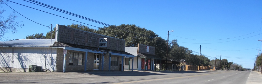


Why visit Harper
Townapedia lists 5 museums and landmarks and 3 places to eat in and around town.
Highlights include Harper Community Park.
August is the warmest month, with average highs of 93°F; January lows average 34°F.
Weather in Harper
Forecast from the National Weather Service. Full forecast
About Harper
Harper is an unincorporated community and census-designated place (CDP), located 23 miles (37 km) west of Fredericksburg on U.S. Highway 290, in Gillespie County, in the U.S. state of Texas. The population was 1,332 at the 2020 census.
From the Wikipedia article Harper, Texas (this version), under CC BY-SA 4.0.
Museums and landmarks5




Restaurants and cafes3



Churches and places of worship3

First Baptist Church Harper
Church · Baptist · 3.0 mi
23038 West US Highway 290, Harper
Gas and EV charging2

History
On December 15, 1847, a petition was submitted to create Gillespie County. In 1848, the legislature formed Gillespie County from Bexar and Travis Counties. While the signers were overwhelmingly German immigrants, names also on the petition were Castillo, Pena, Munos, and a handful of Anglo names.
The first white settlers were the families of Eli McDonald and Matthew Taylor in 1863. A historical marker just south of U.S. Highway 290 commemorates the McDonald massacre of August 1864. This incident involved the killing of two family members and the kidnapping of five more by Kiowa Indians.
A post office was established in 1883 by George Franklin Harper, for whom the town was named. By 1985, the town served a large ranching area and had six churches, a fire department and ambulance services, a public school, and growing residential subdivisions. The population of the area exceeded 1,000 by 2000.
From the History section of Harper, Texas on Wikipedia, under CC BY-SA 4.0.
Schools, colleges and libraries4
Map of Harper
17 places. The map loads OpenStreetMap tiles when you open it.
Climate by month
Monthly table
| Month | High | Low | Rain | Snow |
|---|---|---|---|---|
| Jan | 60°F | 34°F | 1.5 in | 0.0 in |
| Feb | 64°F | 38°F | 1.7 in | 0.0 in |
| Mar | 70°F | 45°F | 2.6 in | 0.0 in |
| Apr | 77°F | 52°F | 2.1 in | 0.0 in |
| May | 83°F | 61°F | 4.2 in | 0.0 in |
| Jun | 89°F | 67°F | 2.8 in | 0.0 in |
| Jul | 92°F | 69°F | 1.7 in | 0.0 in |
| Aug | 93°F | 68°F | 2.1 in | 0.0 in |
| Sep | 87°F | 62°F | 3.2 in | 0.0 in |
| Oct | 79°F | 54°F | 2.7 in | 0.0 in |
| Nov | 68°F | 44°F | 2.1 in | 0.0 in |
| Dec | 61°F | 37°F | 1.6 in | 0.0 in |
U.S. Climate Normals 1991-2020 for Harper 3Ene (5 mi away), NOAA NCEI.
People and cost of living
American Community Survey 5-year estimates, 2020-2024, U.S. Census Bureau. Estimates have margins of error, larger for small towns.
Disaster history
Gillespie County has had 15 federal disaster declarations since 2000, most often for floods.
- 2026-09-01: Severe Storms, Straight-Line Winds, Tornadoes, And Flooding (Flood)
- 2026-07-18: Flooding (Flood)
- 2025-03-15: Crabapple Fire (Fire)
- 2023-04-21: Severe Winter Storm (Winter Storm)
- 2021-02-19: Severe Winter Storms (Severe Ice Storm)
- 2021-02-14: Severe Winter Storm (Severe Ice Storm)
OpenFEMA disaster declarations summaries.
Getting there and nearby towns
Kerrville/Kerr County Airport at Louis Schreiner Field (ERV) is the nearest airport with scheduled flights listed in OpenStreetMap, 23 miles away.
- Ingram 13 mi south, about 21 min by car
- Kerrville 18 mi southeast, about 29 min by car
- Fredericksburg 24 mi east, about 38 min by car
- Center Point 27 mi southeast, about 43 min by car
- Comfort 30 mi southeast, about 48 min by car
- Junction 34 mi northwest, about 54 min by car
- Boerne 47 mi southeast, about 1 h 15 min by car
- Fair Oaks Ranch 52 mi southeast, about 1 h 30 min by car
- Blanco 52 mi east, about 1 h 30 min by car
- Scenic Oaks 53 mi southeast, about 1 h 30 min by car
Drive times are estimates from straight-line distance, not routes.
Local news
Headlines from INDB, the NEMICO news database.
Reviews, tips and questions
Loading what members have shared...
Sources and licences
- NCES EDGE (Public domain): public schools
- NOAA NCEI U.S. Climate Normals 1991-2020 (Public domain): climate by month
- OpenFEMA (Public domain): disaster declarations
- OpenStreetMap contributors (ODbL 1.0): places, airports, map data
- U.S. Census Bureau (Public domain): population, income, housing, education, commute
- Wikidata (CC0 1.0): elevation, founding date, time zone, website
- Wikimedia Commons (see each image): photos
- Wikipedia (CC BY-SA 4.0): overview and history text
Photo credits
- Harper Tx, TigerPaw2154 at English Wikipedia, Public domain
- Harper Texas School, Larry D. Moore, CC BY 4.0
- Harper Texas School WPA Plaque, Larry D. Moore, CC BY 4.0
- Walker's Bar-B-Q - panoramio, Idawriter, CC BY-SA 3.0
- ISS029-E-13653 - View of Earth, Earth Science and Remote Sensing Unit , Lyndon B. Johnson Space Center, Public domain
- ISS045-E-105974 - View of Earth, Earth Science and Remote Sensing Unit , Lyndon B. Johnson Space Center, Public domain
- ISS029-E-15344 - View of Earth, Earth Science and Remote Sensing Unit , Lyndon B. Johnson Space Center, Public domain
- ISS045-E-105975 - View of Earth, Earth Science and Remote Sensing Unit , Lyndon B. Johnson Space Center, Public domain
- ISS045-E-105973 - View of Earth, Earth Science and Remote Sensing Unit , Lyndon B. Johnson Space Center, Public domain
- ISS047-E-153867 - View of Earth, Earth Science and Remote Sensing Unit , Lyndon B. Johnson Space Center, Public domain
- ISS038-E-56794 - View of Earth, Earth Science and Remote Sensing Unit , Lyndon B. Johnson Space Center, Public domain
- ISS038-E-56795 - View of Earth, Earth Science and Remote Sensing Unit , Lyndon B. Johnson Space Center, Public domain
- ISS047-E-153868 - View of Earth, Earth Science and Remote Sensing Unit , Lyndon B. Johnson Space Center, Public domain


Page built October 30, 2026. Spotted a mistake? Tell us or suggest a place.