

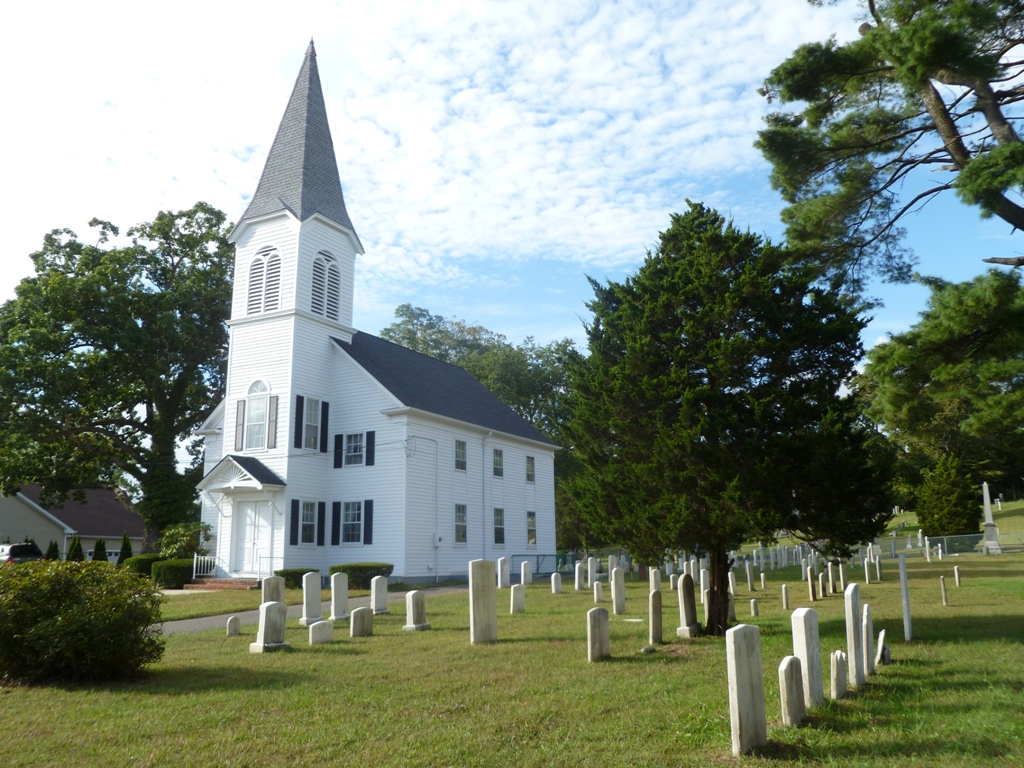


Hauppauge, New York
Hauppauge is a community of 20,793 people in Suffolk County, New York.
Why visit Hauppauge
Townapedia lists 11 museums and landmarks, 31 parks and trails, 48 places to eat, 8 places to stay and 2 attractions in and around town.
Highlights include Sloth Encounters, Spaceplex, Blydenburgh Park Historic District and Caleb Smith State Park Preserve.
July is the warmest month, with average highs of 83°F; January lows average 25°F, and about 32 inches of snow fall in a normal year.
Weather in Hauppauge
Forecast from the National Weather Service. Full forecast
About Hauppauge
Hauppauge is a hamlet and census-designated place (CDP) in the towns of Islip and Smithtown in western Suffolk County, New York, on Long Island. The population was 20,803 at the time of the 2020 census.
From the Wikipedia article Hauppauge, New York (this version), under CC BY-SA 4.0.
Things to do2


Spaceplex
Monument and historic site · 3.6 mi
Indoor amusement park and arcade in New York, US
Museums and landmarks11
Blydenburgh Park Historic District
Monument and historic site · National Register of Historic Places · 1.7 mi
Historic district in New York, United States
Caleb Smith State Park Preserve
Monument and historic site · National Register of Historic Places · 2.2 mi
State park located in Suffolk County, New York, United States

Halliock Inn
Monument and historic site · National Register of Historic Places · 2.8 mi
Historic commercial building in New York, United States

Marion Carll Farm
Monument and historic site · National Register of Historic Places · 4.4 mi
Commack, New York, NRHP-listed

Modern Times School
Monument and historic site · National Register of Historic Places · 3.9 mi
Brentwood, New York, a property listed on the NRHP
Village of the Branch Historic District
Monument and historic site · National Register of Historic Places · 3.3 mi
Historic district in New York, United States
Islandia Veterans Memorial Triangle
Monument and historic site · 2.7 mi
Park and veterans memorial in Islandia, New York, United States

Parks, trails and playgrounds31






19 more on the map.
Restaurants and cafes48

Hauppauge Palace
Restaurant · American, Italian, Sandwich, Burger, Seafood, Greek · 0.9 mi
525 Smithtown Bypass, Hauppauge
Mo-Su 07:00-24:00
Redefine Meals
Restaurant · American, Asian, Mexican, Italian · 1.0 mi
1255 Veterans Memorial Highway, Hauppauge
Mo-Su 08:00-22:00
X-Treme Transportation and Limousine Service Inc
Restaurant · 1.2 mi
96 Gloria Blvd, Hauppauge
Mo-Su 00:00-05:00



Carvel
Ice cream · Ice Cream
553 Veterans Memorial Highway, Hauppauge
Mo-Su 10:00-21:45
Carrabba's Italian Grill
Restaurant · Italian · 3.0 mi
728 Nesconset Highway, Smithtown
Marios Restaurant
Restaurant · Italian · 2.2 mi
644 Vanderbilt Motor Parkway, Hauppauge
36 more on the map.
History
The first house in greater Hauppauge, according to historian Simeon Wood, dates as far back as 1731, located on what would be the Arbuckle Estate, and later the southeast corner of the Hauppauge Industrial Park, near the intersection of Motor Parkway and Old Willets Path. The settlement of Hauppauge proper commenced with the family of Thomas Wheeler prior to 1753, at the present-day location of the BP gas station between Townline and Wheeler Road. The locale would take the Wheelers' name as its own until the 1860s when the name Hauppauge was restored. On March 13, 1806, "a meeting of the male members of the Methodist Society of the 'Haupogues' was convened at the School House agreeable to public notice for the express purpose of Incorporating and Electing Trustees for said Society." The first trustees elected at the meeting presided by Timothy Wheeler and Issac Wheeler were Issac Nichols, Elkanah Wheeler, George Wheeler, and Samuel Brush. They were known as the "Trustees of the Methodist Episcopal Church and Congregation of the Haupogues". In 1812, the Hauppauge Methodist Church that stands today was constructed on land donated by the Wheeler family.
From the History section of Hauppauge, New York on Wikipedia, under CC BY-SA 4.0.
Where to stay8
Residence Inn Long Island Hauppauge/Islandia
Motel and hotel · 0.4 mi
850 Veterans Highway, Hauppauge
Olympic Motor Lodge
Motel and hotel · 2.1 mi
650 Vanderbilt Motor Parkway, Hauppauge
Churches and places of worship21
Commack United Methodist Church and Cemetery
Church · National Register of Historic Places · 4.6 mi
First Presbyterian Church
Church · National Register of Historic Places · 2.6 mi
Kingdom Hall of Jehovah’s Witnesses
Church · Jehovahs Witness · 1.7 mi
221 Old Willets Path, Smithtown
Kingdom Hall of Jehovah’s Witnesses
Church · Jehovahs Witness · 2.4 mi
268 East Suffolk Avenue, Central Islip
First Presbyterian Church of Smithtown
Church · Presbyterian · 2.7 mi
Saint John of God Roman Catholic Church
Church · Catholic · 2.5 mi
90 Carleton Avenue, Central Islip
Central Islip Seventh Day Adventist
Church · 2.7 mi
115 Carleton Avenue, Central Islip
Shopping18
Gas and EV charging20
Schools, colleges and libraries67
The Smithtown Library - Main Branch
Library · 2.7 mi
1 North Country Road, Smithtown
The Smithtown Library - Nesconset Branch
Library · 2.9 mi
148 Smithtown Boulevard, Nesconset
Healthcare7
Map of Hauppauge
233 places. The map loads OpenStreetMap tiles when you open it.
Climate by month
Monthly table
| Month | High | Low | Rain | Snow |
|---|---|---|---|---|
| Jan | 39°F | 25°F | 3.7 in | 10.3 in |
| Feb | 41°F | 26°F | 3.3 in | 9.4 in |
| Mar | 48°F | 32°F | 4.5 in | 6.5 in |
| Apr | 58°F | 41°F | 4.1 in | 0.6 in |
| May | 68°F | 51°F | 3.3 in | 0.0 in |
| Jun | 77°F | 61°F | 4.0 in | 0.0 in |
| Jul | 83°F | 67°F | 3.3 in | 0.0 in |
| Aug | 81°F | 66°F | 4.2 in | 0.0 in |
| Sep | 75°F | 59°F | 3.6 in | 0.0 in |
| Oct | 64°F | 47°F | 4.0 in | 0.0 in |
| Nov | 54°F | 38°F | 3.4 in | 0.5 in |
| Dec | 44°F | 30°F | 4.7 in | 4.5 in |
U.S. Climate Normals 1991-2020 for Islip Li Macarthur Ap 72505 (6 mi away), NOAA NCEI.
People and cost of living
American Community Survey 5-year estimates, 2020-2024, U.S. Census Bureau. Estimates have margins of error, larger for small towns.
Disaster history
Suffolk County has had 25 federal disaster declarations since 2000, most often for hurricanes.
- 2024-10-21: Severe Storm And Flooding (Severe Storm)
- 2024-08-25: Severe Storm And Flooding (Severe Storm)
- 2023-03-15: Severe Winter Storm And Snowstorm (Snowstorm)
- 2021-09-05: Remnants Of Hurricane Ida (Hurricane)
- 2021-09-02: Remnants Of Hurricane Ida (Hurricane)
- 2021-08-22: Hurricane Henri (Hurricane)
OpenFEMA disaster declarations summaries.
Getting there and nearby towns
Long Island MacArthur Airport (ISP) is the nearest airport with scheduled flights listed in OpenStreetMap, 6 miles away.
- Central Islip 3 mi south, about 5 min by car
- Commack 4 mi west, about 7 min by car
- Bay Shore 7 mi south, about 11 min by car
- Dix Hills 7 mi west, about 11 min by car
- East Islip 7 mi south, about 11 min by car
- Deer Park 7 mi southwest, about 12 min by car
- East Northport 7 mi northwest, about 11 min by car
- Elwood 7 mi west, about 11 min by car
- Centereach 7 mi northeast, about 12 min by car
- Fort Salonga 7 mi northwest, about 12 min by car
Drive times are estimates from straight-line distance, not routes.
Local news
Headlines from INDB, the NEMICO news database.
Reviews, tips and questions
Loading what members have shared...
Sources and licences
- NCES EDGE (Public domain): public schools
- NOAA NCEI U.S. Climate Normals 1991-2020 (Public domain): climate by month
- OpenFEMA (Public domain): disaster declarations
- OpenStreetMap contributors (ODbL 1.0): places, airports, map data
- U.S. Census Bureau (Public domain): population, income, housing, education, commute
- Wikidata (CC0 1.0): elevation, founding date, time zone, website, landmarks and historic places
- Wikimedia Commons (see each image): photos
- Wikipedia (CC BY-SA 4.0): overview and history text
Photo credits
- Dennison-building-dog, Americasroof, CC BY-SA 3.0
- Hauppauge United Methodist Church (1806) and Cemetery, Hauppauge, NY, National Register of Historic Places, Corey Geske, CC BY-SA 4.0
- Hauppauge Palace Diner, Kenneth C. Zirkel, CC BY-SA 4.0
- Smithtown 1st Presbyterian Church, DanTD, CC BY-SA 3.0
- Marion Carll Farm Entrance, AJW1188, CC BY-SA 3.0
- Halliock Inn; Village of the Branch-2, DanTD, CC BY-SA 3.0
- Comac Church, AJW1188, CC BY-SA 3.0
- Modern Times School; Brentwood, NY (Over Fence), DanTD, CC BY-SA 3.0
- SCT 9001 Hauppague, Andyidk, CC BY 4.0
- Macronoctua onusta - iNaturalist 734808572, David LaMagna, CC BY 4.0
- Hemyda aurata, Gamfeld, CC0
- Joe DeGuardia Star Boxing, BWGSteelers, CC BY-SA 4.0
- Smithtown, NY, USA - panoramio, dans362, CC BY 3.0
- DJI Mavic Pro x Smithtown (30571326983), John Feinberg, CC BY 2.0
- DJI Mavic Pro x Smithtown (31009527960), John Feinberg, CC BY 2.0
- ISS065-E-96143 - View of Earth, Earth Science and Remote Sensing Unit , Lyndon B. Johnson Space Center, Public domain
- ISS065-E-96142 - View of Earth, Earth Science and Remote Sensing Unit , Lyndon B. Johnson Space Center, Public domain
- ISS007-E-16646 - View of New Jersey, Earth Science and Remote Sensing Unit , Lyndon B. Johnson Space Center, Public domain
- ISS019-E-19569 - View of Earth, Earth Science and Remote Sensing Unit , Lyndon B. Johnson Space Center, Public domain
- ISS019-E-19938 - View of Earth, Earth Science and Remote Sensing Unit , Lyndon B. Johnson Space Center, Public domain
- ISS029-E-30854 - View of Earth, Earth Science and Remote Sensing Unit , Lyndon B. Johnson Space Center, Public domain
- ISS019-E-12146 - View of Earth, Earth Science and Remote Sensing Unit , Lyndon B. Johnson Space Center, Public domain
- ISS047-E-147191 - View of Earth, Earth Science and Remote Sensing Unit , Lyndon B. Johnson Space Center, Public domain
- ISS047-E-147190 - View of Earth, Earth Science and Remote Sensing Unit , Lyndon B. Johnson Space Center, Public domain
- Blydenburgh Miller House, AJW1188, CC BY-SA 3.0
- Blydenburgh Farm Cottage, AJW1188, CC BY-SA 3.0
- Blydenburgh New Mill, AJW1188, CC BY-SA 3.0
- Blydenburgh Weld Farmhouse, AJW1188, CC BY-SA 3.0
- Wyandanch Club, AJW1188, CC BY-SA 3.0
- Wyandanch Club 2, AJW1188, CC BY-SA 3.0
- Wyandanch Club Historic District Panorama, AJW1188, CC BY-SA 3.0
- Central Islip Train Station, Nafsadh, CC BY-SA 4.0
- Byzantine Catholic Church of the Resurrection Rectory, designed by Stickley for Fred Wagner, 1912, Smithtown, NY, Corey Geske, CC BY-SA 4.0
- Byzantine Catholic Church of the Resurrection, formerly St. Patrick's Roman Catholic Church, 1929, Smithtown, NY, Corey Geske, CC BY-SA 4.0
- Smithtown New York Town Hall, Kenneth C. Zirkel, CC BY-SA 4.0
- Renovated LIRR Smithtown Station Waiting Room (19583687795), Metropolitan Transportation Authority of the State of New York, CC BY 2.0
- Renovated LIRR Smithtown Station Waiting Room (19395727240), Metropolitan Transportation Authority of the State of New York, CC BY 2.0
- Renovated LIRR Smithtown Station Waiting Room (19576804682), Metropolitan Transportation Authority of the State of New York, CC BY 2.0
- Renovated LIRR Smithtown Station Waiting Room (19557514276), Metropolitan Transportation Authority of the State of New York, CC BY 2.0
- Renovated LIRR Smithtown Station Waiting Room (19576804232), Metropolitan Transportation Authority of the State of New York, CC BY 2.0


Page built October 30, 2026. Spotted a mistake? Tell us or suggest a place.