
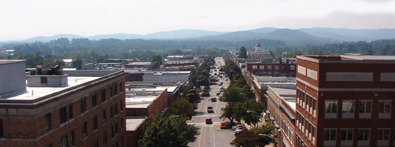


Hendersonville, North Carolina
Hendersonville is a city of 15,408 people in Henderson County, North Carolina, founded in 1838.
Why visit Hendersonville
Townapedia lists 35 museums and landmarks, 18 parks and trails, 86 places to eat, 19 places to stay and 6 attractions in and around town.
Highlights include Epic Theatres of Hendersonville, Flat Rock Playhouse, Mineral & Lapidary Museum and Aloah Hotel.
July is the warmest month, with average highs of 84°F; January lows average 26°F.
Weather in Hendersonville
Forecast from the National Weather Service. Full forecast
About Hendersonville
Hendersonville is a city in and the county seat of Henderson County, North Carolina, United States, located 22 miles (35 km) south of Asheville. Like the county, the city is named for 19th-century North Carolina Supreme Court Chief Justice Leonard Henderson.
From the Wikipedia article Hendersonville, North Carolina (this version), under CC BY-SA 4.0.
Things to do6

Flat Rock Playhouse
Cinema and theater · 3.5 mi
Theater in Flat Rock, Henderson County, North Carolina

Museums and landmarks35

Mineral & Lapidary Museum
Museum · 0.5 mi
Mar-Dec: Mo-Fr 13:00-17:00; Sa 10:00-17:00; Jan, Feb Tu-Fr...

Aloah Hotel
Monument and historic site · National Register of Historic Places · 0.7 mi
United States historic place

Arthur W. Moore House
Monument and historic site · National Register of Historic Places · 3.6 mi
Horse Shoe, North Carolina, listed on the NRHP in North Carolina
Brookland
Monument and historic site · National Register of Historic Places · 1.5 mi
House in Hendersonville, USA

Carl Sandburg Home National Historic Site
Monument and historic site · National Register of Historic Places · 3.9 mi
National Historic Site of the United States
Chewning House
Monument and historic site · National Register of Historic Places · 0.4 mi
Historic house in Henderson, North Carolina, U.S.A.
Clarke-Hobbs-Davidson House
Monument and historic site · National Register of Historic Places · 0.6 mi
Hendersonville, North Carolina, NRHP-listed in Henderson County

Clough H. Rice House
Monument and historic site · National Register of Historic Places · 1.5 mi
Historic house in Hendersonville, North Carolina, U.S.A.
Cold Spring Park Historic District
Monument and historic site · National Register of Historic Places
Historic district in Hendersonville, North Carolina, United States
Druid Hills Historic District
Monument and historic site · National Register of Historic Places · 0.9 mi
Listed on the NRHP in North Carolina


Erle Stillwell House
Monument and historic site · National Register of Historic Places · 1.3 mi
Historic home located at Hendersonville, Henderson County, North Carolina
Erle Stillwell House II
Monument and historic site · National Register of Historic Places · 1.3 mi
Historic house in North Carolina, United States
23 more on the map.
Parks, trails and playgrounds18





6 more on the map.
Restaurants and cafes86

Flat Rock Wood Room
Restaurant · Pizza, Barbecue · 2.2 mi
Check for Winter hours of operation
1501 Greenville Highway
We, Th, Su 11:30-20:00; Fr, Sa 11:30-21:00

Golden Corral
Restaurant · American, Buffet · 2.1 mi
2530 Chimney Rock Road
Mo-Fr 11:00-21:00; Sa-Su 08:00-21:00

Southern Streams CoffeeHouse
Cafe · Bagel, Breakfast, Coffee Shop, Sandwich, Tea · 1.6 mi
1628 5th Avenue West
Mo-Fr 07:00-16:00; Sa 08:00-16:00
Tipsy Taco
Restaurant · Mexican · 0.7 mi
119 South Main Street, Hendersonville
Su-Th 11:00-21:30; Fr-Sa 11:00-22:00
West First Wood-Fired
Restaurant · Pizza · 0.7 mi
101 1st Avenue West, Hendersonville
Mo-Fr 11:00-14:00, 17:00+; Sa 11:00-14:00, 17:00+
Black Bear Coffee Co.
Cafe · Coffee Shop, Sandwich · 0.6 mi
Mo-Th 07:00-17:00; Fr-Sa 07:00-18:00; Su 08:00-16:00
Champa Sushi & Thai Cuisine
Restaurant · Asian · 0.5 mi
North Main Street, Hendersonville
Mo-Fr 11:00-22:00; Sa, Su 12:00-22:00

Dry Falls Brewing
Brewery and winery · 1.0 mi
425 Kanuga Road, Hendersonville
Mo-Th 15:00-22:00; Fr-Sa 12:00-00:00; Su 12:00-21:00
Ecusta Market And Cafe
Restaurant · Coffee Shop · 1.3 mi
877 Lennox Park Drive, Hendersonville
Mo-Sa 08:00-20:00; Su 10:00-18:00

Hannah Flanagan’s Irish Pub
Bar and pub · 0.6 mi
300 North Main Street, Hendersonville
Mo-Su 11:00-02:00
74 more on the map.
Where to stay19
Churches and places of worship23
Grace Blue Ridge
Church · Presbyterian, Pca · 1.8 mi
109 Florence Street, Hendersonville
Moore's Grove United Methodist Church
Church · United Methodist · 2.2 mi
2553 Chimney Rock Road, Hendersonville
First Baptist Church of Hendersonville NC
Church · 0.6 mi
312 5th Avenue West, Hendersonville
First United Methodist Church
Church · 0.5 mi
204 6th Avenue West, Hendersonville
Hendersonville Presbyterian Church
Church · 0.4 mi
699 North Grove Street, Hendersonville
Shopping35
Gas and EV charging11
Schools, colleges and libraries31
Healthcare8
Pardee Urgent Care
Clinic and pharmacy · 1.2 mi
212 Thompson Street, Hendersonville
Map of Hendersonville
250 places. The map loads OpenStreetMap tiles when you open it.
Climate by month
Monthly table
| Month | High | Low | Rain | Snow |
|---|---|---|---|---|
| Jan | 48°F | 26°F | 5.3 in | 2.9 in |
| Feb | 52°F | 29°F | 4.3 in | 0.6 in |
| Mar | 59°F | 35°F | 5.0 in | 1.0 in |
| Apr | 68°F | 43°F | 4.8 in | 0.0 in |
| May | 75°F | 52°F | 4.4 in | 0.0 in |
| Jun | 82°F | 60°F | 5.0 in | 0.0 in |
| Jul | 84°F | 64°F | 5.8 in | 0.0 in |
| Aug | 83°F | 63°F | 5.7 in | 0.0 in |
| Sep | 78°F | 56°F | 5.0 in | 0.0 in |
| Oct | 69°F | 45°F | 4.1 in | 0.0 in |
| Nov | 59°F | 34°F | 4.5 in | 0.1 in |
| Dec | 51°F | 29°F | 5.3 in | 2.1 in |
U.S. Climate Normals 1991-2020 for Hendersonville 1 Ne Hcn (1 mi away), NOAA NCEI.
People and cost of living
American Community Survey 5-year estimates, 2020-2024, U.S. Census Bureau. Estimates have margins of error, larger for small towns.
Disaster history
Henderson County has had 13 federal disaster declarations since 2000, most often for hurricanes.
- 2026-01-24: Severe Winter Storm (Winter Storm)
- 2024-09-28: Tropical Storm Helene (Tropical Storm)
- 2024-09-26: Hurricane Helene (Tropical Storm)
- 2022-10-01: Hurricane Ian (Hurricane)
- 2020-08-02: Hurricane Isaias (Hurricane)
- 2020-03-25: Covid-19 Pandemic (Biological)
OpenFEMA disaster declarations summaries.
Getting there and nearby towns
Asheville Regional Airport (AVL) is the nearest airport with scheduled flights listed in OpenStreetMap, 9 miles away.
- Barker Heights 1 mi southeast, about 2 min by car
- Laurel Park 3 mi west, about 5 min by car
- Balfour 3 mi northwest, about 4 min by car
- Valley Hill 3 mi southwest, about 5 min by car
- East Flat Rock 4 mi southeast, about 6 min by car
- Flat Rock 4 mi south, about 6 min by car
- Mountain Home 4 mi northwest, about 7 min by car
- Dana 5 mi east, about 9 min by car
- Fruitland 5 mi north, about 9 min by car
- Asheville 18 mi north, about 29 min by car
Drive times are estimates from straight-line distance, not routes.
Local news
Headlines from INDB, the NEMICO news database.
Reviews, tips and questions
Loading what members have shared...
Sources and licences
- NCES EDGE (Public domain): public schools
- NOAA NCEI U.S. Climate Normals 1991-2020 (Public domain): climate by month
- OpenFEMA (Public domain): disaster declarations
- OpenStreetMap contributors (ODbL 1.0): places, airports, map data
- U.S. Census Bureau (Public domain): population, income, housing, education, commute
- Wikidata (CC0 1.0): elevation, founding date, time zone, website, landmarks and historic places
- Wikimedia Commons (see each image): photos
- Wikipedia (CC BY-SA 4.0): overview and history text
Photo credits
- Main Street Hendersonville, T.D. Cox, CC BY-SA 3.0
- Hendersonville, NC Train Station view from across the tracks, Todd McDougal, CC BY-SA 3.0
- Hendersonville, NC Train Station street view, Todd McDougal, CC BY-SA 3.0
- Hendersonville, NC, USA - panoramio (5), Mikeiamunion21, CC BY-SA 3.0
- Hendersonville, NC, USA - panoramio (1), Mikeiamunion21, CC BY-SA 3.0
- Hendersonville, NC, USA - panoramio (3), Mikeiamunion21, CC BY-SA 3.0
- Hendersonville, NC, USA - panoramio (4), Mikeiamunion21, CC BY-SA 3.0
- The Waverly - Hendersonville, Upstateherd, CC BY-SA 4.0
- Reformation ARPC, Hendersonville, Nyttend, Public domain
- Grey Hosiery Mill Hendersonville, NC, Todd McDougal, CC BY-SA 3.0
- The Cedars (Hendersonville), Mx. Granger, CC0
- Grey Hosiery Mill - Hendersonville, Upstateherd, CC BY-SA 4.0
- The Cedars - Hendersonville, Upstateherd, CC BY-SA 4.0
- Fifth and Washington, Hendersonville, Nyttend, Public domain
- Clarke-Hobbs-Davidson House - Hendersonville, Upstateherd, CC BY-SA 4.0
- ERLE STILLWELL HOUSE I HENDERSON COUNTY NC, JERRYE & ROY KLOTZ, M.D., CC BY-SA 4.0
- Oakdale Cemetery - Hendersonville, NC I, Upstateherd, CC BY-SA 4.0
- Henderson County, NC 1905 Courthouse, Todd McDougal, CC BY-SA 3.0
- Historic Hendersonville 1, Mx. Granger, CC0
- Carl Sandburg Home National Historic Site, Victoria Stauffenberg, Public domain
- Reese House, Mx. Granger, CC0
- Singletary-Reese-Robinson House, Upstateherd, CC BY-SA 4.0
- Ehringhaus and Fourth, Hendersonville, Nyttend, Public domain
- King Waldrop House, Mx. Granger, CC0
- Inn on Church, Mx. Granger, CC0
- Clough H. Rice House - Hendersonville, Upstateherd, CC BY-SA 4.0
- Mary Mills Coxe house, Indigrrl, CC BY-SA 4.0
- 910 Highland Avenue, Upstateherd, CC BY-SA 4.0
- April 2014 - panoramio, Mikeiamunion21, CC BY-SA 3.0
- 1003 Highland Avenue. House, Upstateherd, CC BY-SA 4.0
- Cold Spring Park, Indigrrl, CC BY-SA 4.0
- 402 & 360 Seventh Street, Upstateherd, CC BY-SA 4.0
- William E. Jamison House, Upstateherd, CC BY-SA 4.0
- Nicholas W. Lefeber House, Upstateherd, CC BY-SA 4.0
- Hyman Heights Entrance, Upstateherd, CC BY-SA 4.0
- Hyman Heights, Indigrrl, CC BY-SA 4.0
- Haywood R. Faison House, Upstateherd, CC BY-SA 4.0
- The Waverly, Mx. Granger, CC0
- Claddagh Inn, Mx. Granger, CC0
- John W. Mcintyre House, Upstateherd, CC BY-SA 4.0


Page built October 30, 2026. Spotted a mistake? Tell us or suggest a place.