
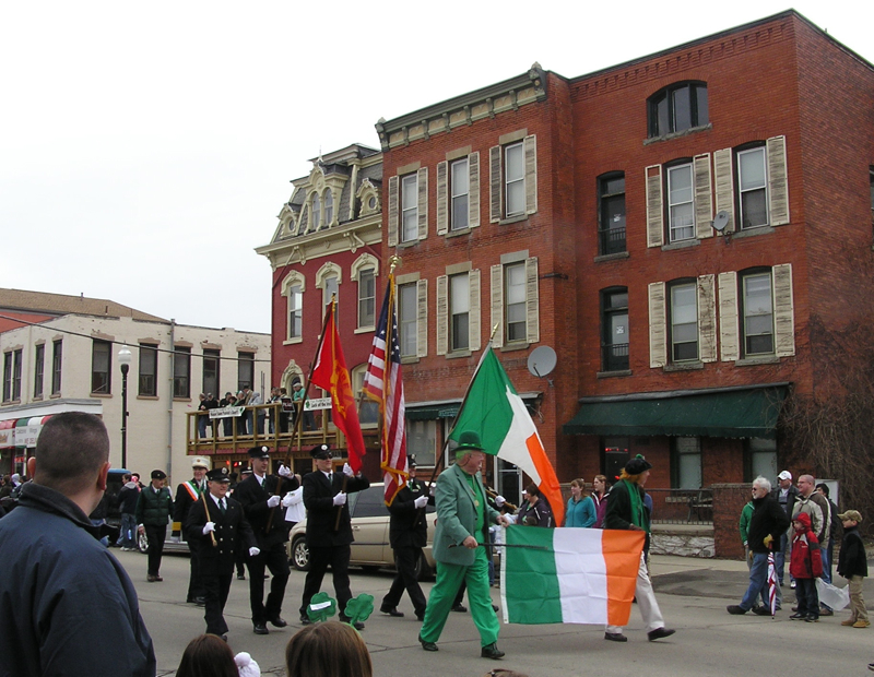


Hornell, New York
Hornell is a city of 8,152 people in Steuben County, New York, founded in 1790.
Why visit Hornell
Townapedia lists 9 museums and landmarks, 6 parks and trails, 11 places to eat, 3 places to stay and 3 attractions in and around town.
Highlights include Spotlight of Hornell, Bald Hill, Hornell Public Library and Adsit House.
July is the warmest month, with average highs of 81°F; January lows average 12°F, and about 62 inches of snow fall in a normal year.
Weather in Hornell
Forecast from the National Weather Service. Full forecast
About Hornell
Hornell is a city in Steuben County, New York, United States. The population was 8,259 at the 2020 census. The city is named after the Hornell family, early settlers.
From the Wikipedia article Hornell, New York (this version), under CC BY-SA 4.0.
Things to do3


Museums and landmarks9

Hornell Public Library
Monument and historic site · National Register of Historic Places · 0.4 mi
Library in Hornell, New York, United States
64 Genesee Street, Hornell
Mo-Tu, Th 12:00-19:00; We 09:00-19:00; Fr 13:00-17:00; Sa 10:00-14:00
Adsit House
Monument and historic site · National Register of Historic Places
Historic house in Hornell, New York
Hornell Armory
Monument and historic site · National Register of Historic Places
Armory in Hornell, United States of America
Lincoln School
Monument and historic site · National Register of Historic Places · 1.2 mi
Building in Hornell, New York
St. Ann's Federation Building
Monument and historic site · National Register of Historic Places · 0.5 mi
Historic commercial building in New York, United States
Temple Beth-El
Monument and historic site · National Register of Historic Places · 0.4 mi
Synagogue in Hornell, New York, United States
United States Post Office
Monument and historic site · National Register of Historic Places
Government building in Hornell, New York

Parks, trails and playgrounds6


Restaurants and cafes11








History
What is now Hornell was first settled in 1790 under the name "Upper Canisteo", to distinguish it from the community of Canisteo, then known as "Lower Canisteo". The family of Benjamin Crosby were the first settlers in what is now Hornell. The area was incorporated as a town in 1820, as "Hornellsville." The name comes from early settler George Hornell Jr, who built the first gristmill here.
The City of Hornell was chartered in 1888 as the "City of Hornellsville," (having been first organized as the "Village of Hornellsville" in 1852). The name was changed to Hornell in 1906.
Major flooding in 1936 put parts of the city under water, prompting the creation of a system of levees to prevent future serious flooding issues.
The former city park, Union Park, was destroyed by the highway construction of the 1970s.
In 1950, Hornell had a population just above 15,000 people. It had two radio stations, WWHG and WLEA, and three movie theaters - the Steuben and the Majestic were located on Broadway, the Hornell on Main Street.
The Hornell Armory, Hornell Public Library, Adsit House, Lincoln School, St. Ann's Federation Building, and United States Post Office are listed on the National Register of Historic Places.
From the History section of Hornell, New York on Wikipedia, under CC BY-SA 4.0.
Where to stay3
Churches and places of worship11
Shopping6
Gas and EV charging3
Schools, colleges and libraries11
Healthcare4
Map of Hornell
67 places. The map loads OpenStreetMap tiles when you open it.
Climate by month
Monthly table
| Month | High | Low | Rain | Snow |
|---|---|---|---|---|
| Jan | 30°F | 12°F | 2.4 in | 16.4 in |
| Feb | 33°F | 13°F | 1.9 in | 13.9 in |
| Mar | 41°F | 20°F | 2.6 in | 11.6 in |
| Apr | 55°F | 30°F | 3.3 in | 2.3 in |
| May | 68°F | 41°F | 3.4 in | 0.1 in |
| Jun | 76°F | 50°F | 4.1 in | 0.0 in |
| Jul | 81°F | 54°F | 4.0 in | 0.0 in |
| Aug | 79°F | 54°F | 3.9 in | 0.0 in |
| Sep | 71°F | 47°F | 3.9 in | 0.0 in |
| Oct | 58°F | 37°F | 3.6 in | 0.3 in |
| Nov | 46°F | 28°F | 2.7 in | 3.5 in |
| Dec | 35°F | 20°F | 2.7 in | 14.0 in |
U.S. Climate Normals 1991-2020 for Hornell Almond Dam (2 mi away), NOAA NCEI.
People and cost of living
American Community Survey 5-year estimates, 2020-2024, U.S. Census Bureau. Estimates have margins of error, larger for small towns.
Disaster history
Steuben County has had 15 federal disaster declarations since 2000, most often for severe storms.
- 2024-09-24: Remnants Of Tropical Storm Debby (Tropical Storm)
- 2021-10-08: Remnants Of Tropical Storm Fred (Hurricane)
- 2020-03-20: Covid-19 Pandemic (Biological)
- 2020-03-13: Covid-19 (Biological)
- 2014-07-08: Severe Storms And Flooding (Severe Storm)
- 2012-10-28: Hurricane Sandy (Hurricane)
OpenFEMA disaster declarations summaries.
Getting there and nearby towns
Dansville Municipal Airport (DSV) is the nearest airport with scheduled flights listed in OpenStreetMap, 17 miles away.
- North Hornell 1 mi north, about 1 min by car
- Canisteo 5 mi southeast, about 8 min by car
- Alfred 8 mi southwest, about 14 min by car
- Dansville 16 mi north, about 26 min by car
- Bath 18 mi east, about 28 min by car
- Nunda 22 mi northwest, about 36 min by car
- Naples 24 mi northeast, about 38 min by car
- Addison 27 mi southeast, about 44 min by car
- Gang Mills 30 mi southeast, about 48 min by car
- Corning 34 mi east, about 54 min by car
Drive times are estimates from straight-line distance, not routes.
Local news
Headlines from INDB, the NEMICO news database.
Reviews, tips and questions
Loading what members have shared...
Sources and licences
- NCES EDGE (Public domain): public schools
- NOAA NCEI U.S. Climate Normals 1991-2020 (Public domain): climate by month
- OpenFEMA (Public domain): disaster declarations
- OpenStreetMap contributors (ODbL 1.0): places, airports, map data
- U.S. Census Bureau (Public domain): population, income, housing, education, commute
- Wikidata (CC0 1.0): elevation, founding date, time zone, website, landmarks and historic places
- Wikimedia Commons (see each image): photos
- Wikipedia (CC BY-SA 4.0): overview and history text
Photo credits
- Hornell NY St Patricks Day, Marduk, CC0
- Hornell, NY 14843, USA - panoramio (28), James Johnson, CC BY 3.0
- Hornell, NY 14843, USA - panoramio (26), James Johnson, CC BY 3.0
- Hornell, NY 14843, USA - panoramio (24), James Johnson, CC BY 3.0
- Hornell, NY 14843, USA - panoramio (27), James Johnson, CC BY 3.0
- Hornell, NY 14843, USA - panoramio (29), James Johnson, CC BY 3.0
- Hornell Armory, NY, Kp1111, CC BY-SA 3.0
- Hornell, NY 14843, USA - panoramio (30), James Johnson, CC BY 3.0
- Hornell, NY 14843, USA - panoramio (19), James Johnson, CC BY 3.0
- Hornell, NY 14843, USA - panoramio (20), James Johnson, CC BY 3.0
- Hornell, NY 14843, USA - panoramio (17), James Johnson, CC BY 3.0
- Hornell, NY 14843, USA - panoramio (16), James Johnson, CC BY 3.0
- US Post Office Hornell 2, NY, Kp1111, CC BY-SA 3.0
- Hornell, NY 14843, USA - panoramio (21), James Johnson, CC BY 3.0
- Hornell, NY 14843, USA - panoramio (23), James Johnson, CC BY 3.0
- Hornell, NY 14843, USA - panoramio (25), James Johnson, CC BY 3.0
- Hornell, NY 14843, USA - panoramio (22), James Johnson, CC BY 3.0
- Hornell, NY 14843, USA - panoramio (31), James Johnson, CC BY 3.0
- Hornell, NY 14843, USA - panoramio (33), James Johnson, CC BY 3.0
- Hornell, NY 14843, USA - panoramio (32), James Johnson, CC BY 3.0
- Hornell, NY 14843, USA - panoramio (34), James Johnson, CC BY 3.0
- Hornell, NY 14843, USA - panoramio (36), James Johnson, CC BY 3.0
- Hornell, NY 14843, USA - panoramio (37), James Johnson, CC BY 3.0
- Hornell, NY 14843, USA - panoramio (35), James Johnson, CC BY 3.0
- Main Street, Hornell, New York - 20210610, Andre Carrotflower, CC BY-SA 4.0
- Hornell, NY 14843, USA - panoramio (15), James Johnson, CC BY 3.0
- Hornell, NY 14843, USA - panoramio (43), James Johnson, CC BY 3.0
- Hornell, NY 14843, USA - panoramio (47), James Johnson, CC BY 3.0
- Hornell, NY 14843, USA - panoramio (45), James Johnson, CC BY 3.0
- Hornell, NY 14843, USA - panoramio (44), James Johnson, CC BY 3.0
- Hornell, NY 14843, USA - panoramio (46), James Johnson, CC BY 3.0
- Hornell, NY 14843, USA - panoramio (52), James Johnson, CC BY 3.0
- Hornell, NY 14843, USA - panoramio (55), James Johnson, CC BY 3.0
- Hornell, NY 14843, USA - panoramio (48), James Johnson, CC BY 3.0
- Hornell, NY 14843, USA - panoramio (49), James Johnson, CC BY 3.0
- Hornell, NY 14843, USA - panoramio (42), James Johnson, CC BY 3.0
- Hornell, NY 14843, USA - panoramio (50), James Johnson, CC BY 3.0
- Hornell, NY 14843, USA - panoramio (51), James Johnson, CC BY 3.0
- Hornell, NY 14843, USA - panoramio (53), James Johnson, CC BY 3.0
- Hornell Public Library 1, NY, Kp1111, CC BY-SA 3.0


Page built October 30, 2026. Spotted a mistake? Tell us or suggest a place.