
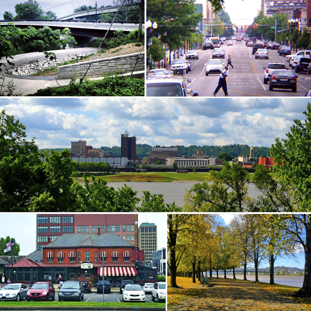


Huntington, West Virginia
Huntington is a city of 45,787 people in Cabell County, West Virginia, founded in February 27, 1871.
Why visit Huntington
Townapedia lists 67 museums and landmarks, 23 parks and trails, 155 places to eat, 10 places to stay and 17 attractions in and around town.
Highlights include Rotary Park Bridge, Pullman Square 16, WWI Memorial Trail and Memorial Arch.
July is the warmest month, with average highs of 87°F; January lows average 25°F.
Weather in Huntington
Forecast from the National Weather Service. Full forecast
About Huntington
Huntington is a city in Cabell and Wayne counties in the U.S. state of West Virginia. It is the county seat of Cabell County and sits at the confluence of the Ohio and Guyandotte rivers in the southwestern part of the state. With a population of 46,842 at the 2020 census (estimated at 44,942 in 2024), Huntington is the second-most populous city in West Virginia. The Huntington–Ashland metropolitan area, spanning seven counties across West Virginia, Kentucky and Ohio, has an estimated 368,000 residents.
From the Wikipedia article Huntington, West Virginia (this version), under CC BY-SA 4.0.
Things to do17

Rotary Park Bridge
Bridge · National Register of Historic Places · 2.2 mi
Bridge in United States of America


Camden Park
Monument and historic site · 5.3 mi
Amusement park located near Huntington, West Virginia


Elizabeth McDowell Lewis College of Business
School · 0.9 mi
Business school of Marshall University
Keith-Albee Theatre
Cinema and theater · 0.9 mi
Theater and movie theater in Huntington, West Virginia, United States
Marshall University
School · 1.3 mi
Public research university in Huntington, West Virginia, United States
West Huntington Bridge
Bridge · 2.9 mi
Bridge in United States of America

Central City Farmers Market
Farm and orchard · 2.5 mi
Jun Sa[4]-Oct 31 Tu,Th,Sa 07:00-14:00
5 more on the map.
Museums and landmarks67

Memorial Arch
Monument and historic site · National Register of Historic Places · 1.6 mi
Memorial arch located in Memorial Park at Huntington, Cabell County, West Virginia

Ninth Street West Historic District
Monument and historic site · National Register of Historic Places · 2.0 mi
Historic district in West Virginia, United States

Ritter Park Historic District
Monument and historic site · National Register of Historic Places · 0.4 mi
Historic district in West Virginia, United States
Barnett Hospital and Nursing School
Monument and historic site · National Register of Historic Places · 0.6 mi
Former hospital
Cabell County Courthouse
Monument and historic site · National Register of Historic Places · 1.0 mi
United States historic place in Huntington, West Virginia

Campbell-Hicks House
Monument and historic site · National Register of Historic Places · 0.8 mi
Historic house in West Virginia, United States
Carnegie Public Library
Monument and historic site · National Register of Historic Places · 0.9 mi
Public library in Huntington, Cabell County, West Virginia
Chesapeake and Ohio 1308
Monument and historic site · National Register of Historic Places · 2.4 mi
Preserved C&O H-6 class 2-6-6-2 locomotive
Douglass Junior and Senior High School
Monument and historic site · National Register of Historic Places · 0.4 mi
High school in West Virginia, United States

Downtown Huntington Historic District
Monument and historic site · National Register of Historic Places · 0.5 mi
US national historic district in Huntington, Cabell County, West Virginia


Elk River Coal and Lumber Company No. 10
Monument and historic site · National Register of Historic Places · 1.1 mi
Preserved American 2-8-2 locomotive
55 more on the map.
Parks, trails and playgrounds23

Ritter Park
Park
Park in Huntington, Cabell County, West Virginia, United States of America
1340 8th Street, Huntington
Camp Mad Anthony Wayne
Park · 5.2 mi
Park in United States of America

11 more on the map.
Restaurants and cafes155

Bahnhof Wvrsthaus + Biergarten
Restaurant · German · 0.8 mi
745 7th Avenue, Huntington
Mo-Th 11:00-22:00; Fr-Sa 11:00-23:00; Su 11:00-20:00
Calamity J Grill & Bar
Restaurant · Burger, Chicken, Salad, Sandwich, Pasta · 1.0 mi
1555 3rd Avenue, Huntington
Mo-Su 11:00-01:00

Le Bistro
Diner · American · 1.0 mi
905 3rd Avenue, Huntington
Mo-Th 10:30-21:00; Fr 10:30-22:00; Sa 10:30-16:00,17:00-22:00; Su...
Nawab Indian Cuisine
Restaurant · Indian · 1.1 mi
600 4th Avenue, Huntington
Mo-Th 11:30-14:30,17:00-22:00;Fr 11:30-14:30,17:00-23:00;Sa...

Starbucks
Cafe · Coffee Shop · 1.0 mi
61 Pullman Square, Huntington
Mo-Fr 05:00-22:00; Sa 05:30-23:00; Su 06:00-22:00
West Tenampa Mexican Restaurant
Restaurant · Mexican · 2.4 mi
1360 Madison Avenue, Huntington
11:00-22:00
Backyard Pizza and Raw Bar
Restaurant · Pizza · 1.1 mi
833 3rd Avenue, Huntington
Tu-Sa 11:00-22:00; Su 11:00-15:00

Baskin-Robbins
Ice cream · Ice Cream · 0.4 mi
1598 Washington Boulevard, Huntington
Su-Th 11:00-21:00; Fr,Sa 11:00-22:00
Marshall Hall of Fame Cafe
Diner · American · 1.0 mi
857 3rd Avenue, Huntington
Su-Th 11:00-22:00; Fr,Sa 11:00-23:00
Taste of Asia Hibachi
Restaurant · Japanese, Steak House · 1.1 mi
821 3rd Avenue, Huntington
Mo-Th 10:30-21:30; Fr,Sa 10:30-22:30; Su 11:30-21:30
Bob Evans
Diner · American · 1.4 mi
121 Kinetic Drive, Huntington
Mo-Su 07:00-21:00
143 more on the map.
History
Discounting the period of French ownership, the land that was part of Guyandotte and later Huntington was originally part of the 28,628-acre (115.85 km2) French and Indian War veteran's Savage Grant. The area of greater Huntington, although situated in a Southern state, was long considered a western city in what was then the Colony of Virginia since the first permanent settlements were founded in 1775 in defiance of British injunctions against settlements west of the Alleghenies in the vicinity of Holderby's Landing.
From the History section of Huntington, West Virginia on Wikipedia, under CC BY-SA 4.0.
Where to stay10
Churches and places of worship120
First United Methodist Church
Church · 0.8 mi
1124 5th Avenue, Huntington
Shopping46
Gas and EV charging27
Schools, colleges and libraries51
Healthcare35
Map of Huntington
250 places. The map loads OpenStreetMap tiles when you open it.
Climate by month
Monthly table
| Month | High | Low | Rain | Snow |
|---|---|---|---|---|
| Jan | 44°F | 25°F | 3.4 in | 4.3 in |
| Feb | 48°F | 28°F | 3.3 in | 2.5 in |
| Mar | 56°F | 34°F | 4.2 in | 2.1 in |
| Apr | 69°F | 43°F | 4.0 in | 0.0 in |
| May | 77°F | 53°F | 4.5 in | 0.0 in |
| Jun | 84°F | 62°F | 4.0 in | 0.0 in |
| Jul | 87°F | 66°F | 4.8 in | 0.0 in |
| Aug | 86°F | 65°F | 4.0 in | 0.0 in |
| Sep | 81°F | 57°F | 3.4 in | 0.0 in |
| Oct | 70°F | 45°F | 3.0 in | 0.0 in |
| Nov | 57°F | 35°F | 2.8 in | 0.0 in |
| Dec | 47°F | 30°F | 3.8 in | 1.3 in |
U.S. Climate Normals 1991-2020 for Huntington Swg Pl (5 mi away), NOAA NCEI.
People and cost of living
American Community Survey 5-year estimates, 2020-2024, U.S. Census Bureau. Estimates have margins of error, larger for small towns.
Disaster history
Cabell County has had 24 federal disaster declarations since 2000, most often for severe storms.
- 2026-01-24: Severe Winter Storm (Winter Storm)
- 2024-05-22: Severe Storms, Straight-Line Winds, Tornadoes, Flooding, Landslides, And Mudslides (Severe Storm)
- 2021-05-20: Severe Storms And Flooding (Flood)
- 2021-05-13: Severe Winter Storms (Severe Ice Storm)
- 2020-04-03: Covid-19 Pandemic (Biological)
- 2020-03-13: Covid-19 (Biological)
OpenFEMA disaster declarations summaries.
Getting there and nearby towns
Lawrence County Airpark (HTW) is the nearest airport with scheduled flights listed in OpenStreetMap, 3 miles away.
- Chesapeake 2 mi northwest, about 3 min by car
- Proctorville 3 mi northeast, about 5 min by car
- Burlington 5 mi west, about 8 min by car
- Pea Ridge 6 mi east, about 10 min by car
- Ceredo 6 mi west, about 10 min by car
- Lavalette 6 mi south, about 10 min by car
- Ashland 12 mi west, about 19 min by car
- Ironton 16 mi northwest, about 25 min by car
- Portsmouth 37 mi northwest, about 59 min by car
- Charleston 44 mi east, about 1 h 15 min by car
Drive times are estimates from straight-line distance, not routes.
Local news
Headlines from INDB, the NEMICO news database.
Reviews, tips and questions
Loading what members have shared...
Sources and licences
- NCES EDGE (Public domain): public schools
- NOAA NCEI U.S. Climate Normals 1991-2020 (Public domain): climate by month
- OpenFEMA (Public domain): disaster declarations
- OpenStreetMap contributors (ODbL 1.0): places, airports, map data
- U.S. Census Bureau (Public domain): population, income, housing, education, commute
- Wikidata (CC0 1.0): elevation, founding date, time zone, website, landmarks and historic places
- Wikimedia Commons (see each image): photos
- Wikipedia (CC BY-SA 4.0): overview and history text
Photo credits
- HWV Collage, Wvfunnyman, CC BY-SA 3.0
- Ritter Park Historic District Houses Huntington WV 2023, Wv funnyman, CC BY-SA 4.0
- Cabell Huntington Hospital 2014, Wv funnyman, CC BY-SA 4.0
- Memorial Arch 2012-10-04 14-18-04, Jrappold, CC BY-SA 3.0
- RitterParkFountain, Youngamerican at en.wikipedia, CC BY-SA 3.0
- Parsons-Abbott-Mosser House, Nyttend, Public domain
- Mortimer Place HuntingtonWV, Youngamerican ( talk ), CC BY-SA 3.0
- Downtown Huntington Historic District, 4th and 7th, Nyttend, Public domain
- Marshall University Old Main Building, Wvfunnyman, CC BY-SA 3.0
- Foster Memorial Home, Nyttend, Public domain
- University Heights Huntington WV, Youngamerican ( talk ), CC BY-SA 3.0
- OldHuntingtonHigh(WV), Youngamerican ( talk ), CC BY-SA 3.0
- Simms School Huntington WV, Youngamerican ( talk ), CC BY-SA 3.0
- Coin Harvey House Huntington WV, Youngamerican ( talk ), CC BY-SA 3.0
- Rotary Park Bridge 2013-09-19 01-34-02, thekingofmice, CC BY-SA 3.0
- RICKETS HOUSE, HUNTINGTON, CABELL COUNTY, WV, JERRYE & ROY KLOTZ M.D., CC BY-SA 4.0
- Campbell-Hicks House 2012-10-14 15-17-10, Jrappold, CC BY-SA 3.0
- River Tower Huntington WV, Youngamerican ( talk ), CC BY-SA 3.0
- Thomas Carroll House 1, Thekingofmice, CC BY-SA 3.0
- Elk River C&L Co 10 Loco Huntington WV, Youngamerican ( talk ), CC BY-SA 3.0
- Prichard House 2012-10-04 19-46-15, Jrappold, CC BY-SA 3.0
- Johnston-Meek House, Nyttend, Public domain
- Liggett and Myers 2, Thekingofmice, CC BY-SA 3.0
- PXL 20220510 222858411, ScientistBuilder, CC BY-SA 4.0
- PXL 20220521 163948107, ScientistBuilder, CC BY-SA 4.0
- PXL 20220521 162032524, ScientistBuilder, CC BY-SA 4.0
- PXL 20220521 162005778, ScientistBuilder, CC BY-SA 4.0
- PXL 20220521 162041961, ScientistBuilder, CC BY-SA 4.0
- PXL 20220521 162017299, ScientistBuilder, CC BY-SA 4.0
- PXL 20220521 162034337, ScientistBuilder, CC BY-SA 4.0
- PXL 20220521 162030244, ScientistBuilder, CC BY-SA 4.0
- PXL 20220521 162025912, ScientistBuilder, CC BY-SA 4.0
- PXL 20220521 162039575, ScientistBuilder, CC BY-SA 4.0
- PXL 20220521 162045748, ScientistBuilder, CC BY-SA 4.0
- PXL 20220521 162103340, ScientistBuilder, CC BY-SA 4.0
- PXL 20220521 162108917, ScientistBuilder, CC BY-SA 4.0
- PXL 20220624 182929342, WalkingRadiance, CC BY-SA 4.0
- PXL 20220522 190724891, ScientistBuilder, CC BY-SA 4.0
- PXL 20220522 190712726, ScientistBuilder, CC BY-SA 4.0
- PXL 20220522 190715018, ScientistBuilder, CC BY-SA 4.0


Page built October 30, 2026. Spotted a mistake? Tell us or suggest a place.