


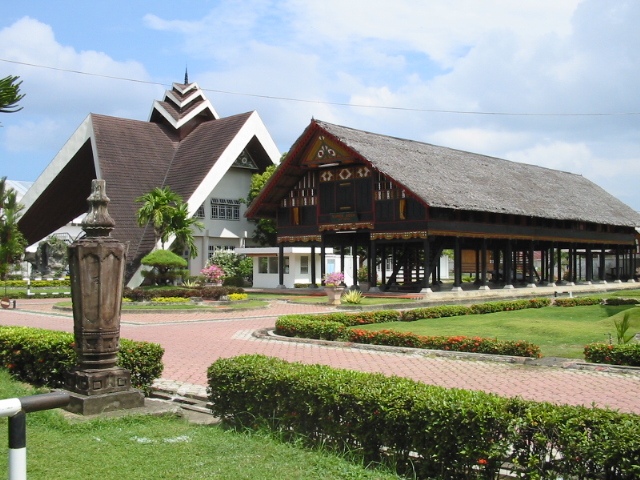


Banda Aceh, Indonesia
Banda Aceh is a regional capital of 267,962 people in Aceh, Indonesia, founded in April 29, 1205.
Why visit Banda Aceh
Townapedia lists 22 museums and landmarks, 19 parks and trails, 79 places to eat, 31 places to stay and 4 attractions in and around town.
Highlights include Abulyatama University, State Islamic University Ar-Raniry, Museum Tsunami Aceh and Rumoh Aceh 1915.
Weather in Banda Aceh
Forecast from MET Norway (CC BY 4.0). Full forecast
About Banda Aceh
Banda Aceh ( BUN-də AH-chay; Acehnese: Banda Acèh, Jawoe: بند اچيه) is the capital and largest city in the province of Aceh, Indonesia. It is located on the island of Sumatra and has an elevation of 35 metres (115 ft). The city covers an area of 61.36 square kilometers (23.69 sq mi) and had a population of 223,446 people at the 2010 Census, rising to 252,899 at the 2020 Census. The official estimate as of 2025 was 267,962 (comprising 134,451 males and 133,511 females).
From the Wikipedia article Banda Aceh (this version), under CC BY-SA 4.0.
Travel tips from other travellers: Banda Aceh on Wikivoyage (CC BY-SA 4.0).
Things to do4


State Islamic University Ar-Raniry
School · 5.6 km
Public university and academic publisher
Syiah Kuala University
School · 5.2 km
National university in Aceh, Indonesia
Museums and landmarks22

Museum Tsunami Aceh
Museum · 2.1 km
Jalan Sultan Iskandar Muda, Banda Aceh
Mo-Th, Sa 09:00-12:00, 14:00-16:30; Fr 09:00-11:30, 14:30-16:30
Rumoh Aceh 1915
Museum · 1.6 km
Jalan Sultan Mahmudsyah, Kota Banda Aceh
Mo-Su 09:00-16:00



10 more on the map.
Parks, trails and playgrounds19






7 more on the map.
Restaurants and cafes79


Arah Selatan
Cafe · Breakfast, Coffee Shop, Indonesian, Tea · 1.9 km
98 Jalan Mohammad Daud Beureueh
Su-Sa 09:00-23:00
Kebab Mufasa
Restaurant · Kebab, Burger, Fast Food, Street Food · 1.9 km
Jalan T. Iskandar, Banda Aceh
Mo-Su 17:00-24:00
Warung Omtom
Restaurant · Coffee Shop, Cake · 0.6 km
Jalan Ir. H. Mohammad Thaher, Banda Aceh
Mo-Su 07:00-23:00
Ayah Gadeng II
Cafe · Coffee Shop · 1.2 km
1 Jl. Nyak Adam Kamil II
Mo-Su 06:00-22:00
Ayam Penyet Surabaya
Restaurant · Diner, Indonesian, Chicken · 1.7 km
Lambhuk, Ulee Kareng, Banda Aceh City, Aceh, Banda Aceh
Mo-Su 10:00-23:00
De’Yus Coffee Ulee Kareng
Cafe · Coffee Shop · 3.1 km
Jalan Soekarno-Hatta
Mo-Su 06:05-12:00

Beutari Cake & cookies
Bakery · 2.5 km
Komplek beutari permai jl. cot peulangge 2 No.22, Lampeuneurut Gampong, Kec. Darul Imarah, Kota Banda Aceh, Aceh, Aceh Besar
24/7
67 more on the map.
History
Banda Aceh, situated at the tip of Sumatra, has long been a strategic transportation and trading hub in the eastern Indian Ocean. Its first mention in western accounts comes from 1292 when Marco Polo and his expedition visited the city, referred to as 'Lambri' from Lamuri Kingdom which previously existed there and noted as the logical first port of call for travellers from Arabia and India to Indonesia. Ibn Battuta also reported visiting the city in the mid-14th century when under the control of the trading kingdom of Samudera Pasai, the then-dominant entity in northern Sumatra. However the Pasai began to collapse under pressure from declining economic conditions and the Portuguese, who occupied much of the area after occupying Malacca in the early 16th century. Sultan Ali Mughayat Syah, ruler of the newly founded Sultanate of Aceh, aggressively expanded in the area in the 1520s and established sultanate was built on the remains of the Pasai and other extinct kingdoms in the area, and made Banda Aceh the capital, naming it for himself as Kutaraja or 'City of the King'.
From the History section of Banda Aceh on Wikipedia, under CC BY-SA 4.0.
Where to stay31
Crystall Guesthouse
Motel and hotel · 2.6 km
3C Jalan Sultan Iskandar Muda, Banda Aceh
Churches and places of worship119
Baiturrahman Grand Mosque
Place of worship · Sunni · 2.2 km
Jalan Mohammad Jam, Banda Aceh
Masjid At-thahirah
Place of worship · Sunni · 1.7 km
Jalan Ir. H. Mohammad Thaher
Masjid Raudhatul Jannah Gampong Pango Raya
Place of worship · Sunni · 1.5 km
1 Jalan Masjid, Banda Aceh
Masjid Al Ishlahiyah
Place of worship · 1.6 km
Jalan Prof. DR. T. Syarief Thayeb, Banda Aceh
Shopping65
Neneng Catering & Wedding organizer
Shop · 3.2 km
94 jln. wedana, lorong jati no.94 desa mibo banda aceh
Pentas Seni Taman Sari
Shop · 2.0 km
Jalan Teungku Abdullah Ujong Rimba, Banda Aceh
Gas and EV charging8
Schools, colleges and libraries129
Healthcare91
Rumah Sakit Umum Zainoel Abidin
Hospital · 2.6 km
108 Jalan Mohammad Daud Beureueh, Banda Aceh
Puskesmas Lampaseh Kota
Clinic and pharmacy · 3.0 km
Jalan Rama Setia Lorong Syahmidin, Banda Aceh
Map of Banda Aceh
250 places. The map loads OpenStreetMap tiles when you open it.
Getting there and nearby towns
Sultan Iskandar Muda International Airport (BTJ) is the nearest airport with scheduled flights listed in OpenStreetMap, 10 km away.
- Sabang 39 km north, about 39 min by car
- Sigli 72 km east, about 1 h 15 min by car
Drive times are estimates from straight-line distance, not routes.
Local news
Headlines from INDB.
Reviews, tips and questions
Loading what members have shared...
Sources and licences
- GeoNames (CC BY 4.0): population, coordinates, regions and time zone
- OpenStreetMap contributors (ODbL 1.0): places, airports, map data
- Wikidata (CC0 1.0): elevation, founding date, time zone, website, landmarks and historic places
- Wikimedia Commons (see each image): photos
- Wikipedia (CC BY-SA 4.0): overview and history text
Photo credits
- Coast of Banda Aceh 2-12-05 050212-N-1450G-241, Photographer's Mate 1st Class Jon Gesch, USN, Public domain
- Vihara Dharma Bhakti Banda Aceh, Si Gam, CC BY-SA 4.0
- Fakultas Ushuluddin UIN Ar-Raniry, Si Gam, CC BY-SA 3.0
- Museum Aceh, Si Gam, CC BY-SA 3.0
- Aceh Tsunami Museum site visit; February 2020 (25), Rachmat04, CC BY-SA 3.0
- Meuseujid Raya Bayturrahman, Si Gam Acèh, CC BY-SA 3.0
- Stadion Harapan Bangsa, Darul Mukarramah, CC0
- H. Di Murthala Stadium, Si Gam, CC BY-SA 4.0
- Gereja Hati Kudus Banda Aceh, Si Gam, CC BY-SA 4.0
- Stadion Harapan Bangsa, Banda Aceh (cropped), Si Gam, CC BY-SA 4.0
- Meuseujid Raya Baiturrahman, Si_Gam, CC BY-SA 3.0
- KPU Jamaluddin Thaib, Komisi Pemilihan Umum, Public domain
- Suji Edwar, Suji edwar, CC BY-SA 4.0
- Pink sunset 20260129 064856, MalemDiwa67, CC0
- Picture of the sun facing the camera directly, MalemDiwa67, CC0
- Makam Sultan Syamsu Syah, Si Gam, CC BY-SA 4.0
- Mesjid Baiturrahman NAD - panoramio, Fadillah Jafar, CC BY 3.0
- Head Tombstone of Sultan Mansur Syah of Aceh, Si Gam, CC BY-SA 4.0
- Grave of Sultan Mansur Syah of Aceh, Si Gam, CC BY-SA 4.0
- Tulak Angen Bale Museum Aceh, Si Gam, CC BY-SA 4.0
- Bungong Seulanga dan Rumoh Aceh, Ritaza, CC BY-SA 4.0
- Neusu Inscription, Si Gam, CC BY-SA 4.0
- Jirat Sôleutan Al-Qahhar, Si Gam, CC BY-SA 4.0
- Jirat Sôleutan Ali Ri'ayat Syah bin Alauddin bin Ali Mughayat Syah., Si Gam, CC BY-SA 4.0
- Fishing boat arrived in the morning (8217735878), Pavel Kirillov from St.Petersburg, Russia, CC BY-SA 2.0
- Maulana Akbar, Orangblog100, CC BY-SA 4.0
- Dewan Perwakilan Rakyat Aceh, Si Gam, CC BY-SA 4.0
- Generator ship lands 5 km inland after 2004 Indian Ocean earthquake and tsunami; Andy Doyle; July 2008, Andy Doyle from Dublin, Republic of Ireland, CC BY 2.0
- Alam Peudeueng, Si Gam, CC BY-SA 3.0
- Mie Caluk "Spaghettinya Aceh", Desi Arida, CC BY-SA 4.0
- Timphan Asoe Kaya, Si Gam, CC BY-SA 4.0
- Harapan untuk Aceh dalam acara peringatan 9 tahun tsunami Aceh; 2013, Rachmat.Wahidi, CC BY 3.0
- Kodam Iskandar Muda 2026, Si Gam, CC BY-SA 3.0
- A hope written in a paper hanged in bamboo branch; rachmatwahidi; December 2013, rachmatwhd from Banda Aceh, Indonesia, CC BY-SA 2.0
- Aceh Tsunami Museum site visit; February 2020 (36), Rachmat04, CC BY-SA 3.0
- Aceh Tsunami Museum site visit; February 2020 (21), Rachmat04, CC BY-SA 3.0
- Aceh Tsunami Museum site visit; February 2020 (46), Rachmat04, CC BY-SA 3.0
- Aceh Tsunami Museum site visit; February 2020 (01), Rachmat04, CC BY-SA 3.0
- Aceh Tsunami Museum site visit; February 2020 (19), Rachmat04, CC BY-SA 3.0
- Aceh Tsunami Museum site visit; February 2020 (23), Rachmat04, CC BY-SA 3.0
- Lintasan lari laun di Lapangan Blang Padang, Banda Aceh; 2014, Rachmat Wahidi, CC BY-SA 4.0


Page built November 3, 2026. Spotted a mistake? Tell us or suggest a place.