


Semarang, Indonesia
Semarang is a regional capital of 1,694,740 people in Central Java, Indonesia, founded in May 12, 1547.
Why visit Semarang
Townapedia lists 9 museums and landmarks, 24 parks and trails, 96 places to eat, 70 places to stay and 6 attractions in and around town.
Highlights include Diponegoro University, Soegijapranata Catholic University, Tugu Muda and Candi War Cemetery.
Weather in Semarang
Forecast from MET Norway (CC BY 4.0). Full forecast
About Semarang
Semarang (Javanese: ꦏꦸꦛꦯꦼꦩꦫꦁ, Kutha Semarang) is the capital and largest city of Central Java province in Indonesia. It was a major port during the Dutch colonial era, and is still an important regional center and port today. The city has been named as the cleanest tourist destination in Southeast Asia by the ASEAN Clean Tourist City Standard (ACTCS) for 2020–2022.
From the Wikipedia article Semarang (this version), under CC BY-SA 4.0.
Travel tips from other travellers: Semarang on Wikivoyage (CC BY-SA 4.0).
Things to do6

Diponegoro University
School · 6.5 km
National university in Central Java, Indonesia

Soegijapranata Catholic University
School · 4.0 km
Catholic university in Indonesia

State University of Semarang
School · 7.1 km
National university in Central Java, Indonesia
Universitas Islam Negeri Walisongo
School · 6.8 km
Higher education institution in Semarang, Indonesia

Museums and landmarks9


Candi War Cemetery
Monument and historic site · 2.1 km
Dutch war cemetery in Semarang, Indonesia

Indonesian World Records Museum
Museum · 8.5 km
Museum in Central Java, Indonesia

Kalibanteng War Cemetery
Monument and historic site · 4.2 km
Dutch war cemetery in Semarang, Indonesia
Ranggawarsita Museum
Museum · 4.2 km
Ethnographic museum in Semarang, Central Java, Indonesia

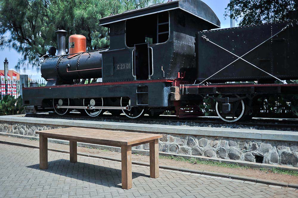


C 2301
Monument and historic site · 1.6 km
Sächsische Maschinenfabrik vormals Richard Hartmann, Chemnitz

Parks, trails and playgrounds24


12 more on the map.
Restaurants and cafes96

Soto Bangkong
Restaurant · Breakfast, Indonesian, Local · 1.3 km
2C Jalan Brigadir Jenderal Katamso
Mo-Su 07:00-21:00

Makabana
Cafe · Sandwich, Breakfast, Grill, French, Cake, Asian, Coffee Shop · 1.0 km
22B Jalan Diponegoro
Mo-Su 07:00-22:00
Asem-Asem Koh Liem
Restaurant · Indonesian, Regional, Local · 1.5 km
28 Jalan Karanganyar
Mo-Su 07:00-17:00
Toko ANEKA DEJAPAS Semarang - Roti, Kue, Snack, dan Jajanan Pasar
Restaurant · Indonesian, Regional, Snack · 1.7 km
Jalan Penaton, Semarang
Aneka Wedang & Es Puter Mataram "Pak Kirman"
Cafe · Indonesian · 1.7 km
406 Jalan MT. Haryono, Semarang
Mo-Su 19:00-24:00
The Tavern
Restaurant · Steak House, Pizza · 1.8 km
No.1 Jl. Rinjani Jl. Sumbing No.1, Bendungan, Gajahmungkur, Kota Semarang, Jawa Tengah 50231
Mo-Th 16:00-00:00; Fr 16:00-00:30; Sa 16:00-1:30; Su 16:00-00:30
Depot Sate Babi Kelengan
Restaurant · 1.6 km
18 & 22 Wotgandul Barat
We-Mo 11:00-21:00
84 more on the map.
History
The history of Semarang goes back to the 9th century, when it was known as Bergota. At the end of the 15th century, the Demak Sultanate appointed an Islamic scholar named Ki Ageng Pandan Arang to build an Islamic school in this fishing village. On 2 May 1547, Sultan Hadiwijaya of Pajang declared Pandan Arang as the first bupati (mayor) of Semarang, thus creating Semarang administratively and politically.
In 1678, Sunan Amangkurat II promised to give control of Semarang to the Dutch East India Company (VOC) as a part of a debt payment. In 1682, the Semarang state was founded by the Dutch colonial power. On 5 October 1705 after years of occupations, Semarang officially became a VOC city when Susuhunan Pakubuwono I made a deal to give extensive trade rights to the VOC in exchange of wiping out Mataram's debt. The VOC, and later, the Dutch East Indies government, established tobacco plantations in the region and built roads and railroads, making Semarang an important colonial trading centre.
The historic presence of a large Indo (Eurasian) community in the area of Semarang is also reflected by the fact a creole mix language called Javindo existed there.
From the History section of Semarang on Wikipedia, under CC BY-SA 4.0.
Where to stay70
Hotel Santika Premiere Slipi Jakarta
Motel and hotel
No. 7 Jalan Aipda K. S. Tubun, Slipi, West Jakarta
Churches and places of worship189
Masjid Jami' Al-Amanah
Place of worship · Sunni · 1.8 km
Jalan Jomblang Barat I, Semarang
Shopping18
Gas and EV charging5
Schools, colleges and libraries114
Healthcare57
Map of Semarang
250 places. The map loads OpenStreetMap tiles when you open it.
Getting there and nearby towns
Ahmad Yani Airport (SRG) is the nearest airport with scheduled flights listed in OpenStreetMap, 6 km away.
- Mranggen 11 km east, about 11 min by car
- Ungaran 16 km south, about 16 min by car
- Jimbaran 19 km south, about 19 min by car
- Demak 27 km northeast, about 27 min by car
- Ambarawa 30 km south, about 30 min by car
- Salatiga 39 km south, about 39 min by car
- Weleri 39 km west, about 39 min by car
- Welahan 39 km northeast, about 39 min by car
- Pecangaan 46 km northeast, about 46 min by car
- Jepara 52 km northeast, about 52 min by car
Drive times are estimates from straight-line distance, not routes.
Local news
Headlines from INDB.
Reviews, tips and questions
Loading what members have shared...
Sources and licences
- GeoNames (CC BY 4.0): population, coordinates, regions and time zone
- OpenStreetMap contributors (ODbL 1.0): places, airports, map data
- Wikidata (CC0 1.0): elevation, founding date, time zone, website, landmarks and historic places
- Wikimedia Commons (see each image): photos
- Wikipedia (CC BY-SA 4.0): overview and history text
Photo credits
- Lokasi Kaki Lima Taman KB Semarang - panoramio, Muhammad Cordiaz, CC BY-SA 3.0
- Simpang Lima Semarang - panoramio, Muhammad Cordiaz, CC BY-SA 3.0
- Simpang Lima Semarang - panoramio (cropped), Muhammad Cordiaz, CC BY-SA 3.0
- Tahu gimbal in Semarang, M.akbar.raf, CC BY-SA 4.0
- Simpang Lima Semarang, Fhikri Latifi, CC BY 4.0
- TransSemarang 3rd Corridor Bus, FarhanSyafiqF, CC BY-SA 4.0
- TransSemarang 5th Corridor Bus, Farhan Syafiq Fadhillah, CC BY-SA 4.0
- Simpang Lima Semarang - panoramio (1), ahmad yudi, CC BY-SA 3.0
- Simpang 5 Semarang - panoramio, ahmad yudi, CC BY-SA 3.0
- Kotak Surat Jalan Pahlawan Semarang - panoramio, Muhammad Cordiaz, CC BY-SA 3.0
- Semarang, Indonesia - panoramio (2), Agron Merseli, CC BY 3.0
- Semarang, Indonesia - panoramio, Agron Merseli, CC BY 3.0
- Semarang, Indonesia - panoramio (1), Agron Merseli, CC BY 3.0
- Halte Trans Semarang Pandanarang, Fhikri Latifi, CC BY 4.0
- Trans Semarang 1st Corridor Bus, Farhan Syafiq Fadhillah, CC BY-SA 4.0
- Hotel Ciputra Simpang Lima Semarang - panoramio, Baharuddin Banyumule…, CC BY-SA 3.0
- Trans Semarang Simpang Lima Stations, Farhan Syafiq Fadhillah, CC BY-SA 4.0
- Hotel Ciputra Bakery, Semarang, Indonesia - panoramio, Agron Merseli, CC BY 3.0
- 2017 Mitsubishi Pajero Sport Dakar & 2019 Mitsubishi Xpander Ultimate, Semarang, Alex Neman, CC BY-SA 4.0
- 2019 Toyota Kijang Innova 2.0 G (rear), Semarang, Alex Neman, CC BY-SA 4.0
- 2019 Honda Brio Satya 1.2 E (rear), Semarang, Alex Neman, CC BY-SA 4.0
- Soto Semarang, Fitri Penyalai, CC BY-SA 4.0
- Universitas Soegriya Pranata, PL09Puryono, CC0
- Unnes, PL09Puryono, CC0
- Ereveld Candi, Oorlogsgraven stichting, CC BY 2.5
- Kalibanteng, OGS, CC BY 2.5
- Gereja-blenduk, id:user:Acong, CC BY 3.0
- Randusari interior, Crisco 1492, CC BY-SA 3.0
- Exterior, Gedangan Church, 2014-06-18, Crisco 1492, CC BY-SA 3.0
- COLLECTIE TROPENMUSEUM Het hoofdkantoor van de Nederlands-Indische Spoorweg Maatschappij in Semarang TMnr 60026221, Unknown author Unknown author, CC BY-SA 3.0
- Locomotive and Teak Table in front of Lawang Sewu building, Semarang, Souren Meubels , http://sourenmeubels.nl/, CC BY-SA 3.0
- Becak Tugu Muda Semarang Central Java, Midori, CC BY-SA 3.0
- Lawang sewu semarang, Galuhranitiara, CC BY-SA 4.0
- Taman indonesia kaya, Aguswindarto, CC BY-SA 4.0
- Sisi taman indonesia kaya, Aguswindarto, CC BY-SA 4.0
- Balloon, Seika N, CC BY 3.0
- One Sided, Seika N, CC BY 3.0
- Malam di Simpang Lima - panoramio, wowo_s, CC BY 3.0
- Rider, Seika N, CC BY 3.0
- Simpanglima - panoramio, Agus Java, CC BY 3.0


Page built November 3, 2026. Spotted a mistake? Tell us or suggest a place.