


Why visit Akola
Townapedia lists 7 parks and trails, 34 places to eat, 19 places to stay and 3 attractions in and around town.
Highlights include Dr. Panjabrao Deshmukh Krishi Vidyapeeth and Miraj Cinemas: Radha Krishna.
Weather in Akola
Forecast from MET Norway (CC BY 4.0). Full forecast
About Akola
Akola () is a major city in the Vidarbha region of the Indian state of Maharashtra. With an estimated population of 600,000, Akola is a growing metropolis surrounded by forts, and has the Morna River running through the center of the city.
From the Wikipedia article Akola (this version), under CC BY-SA 4.0.
Things to do3
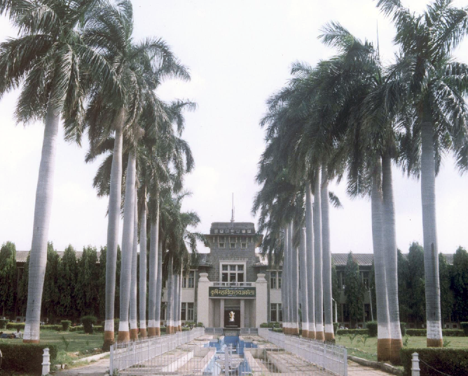


Dr. Panjabrao Deshmukh Krishi Vidyapeeth
School · 4.2 km
State public university in Akola, Maharashtra, India

Parks, trails and playgrounds7



Restaurants and cafes34

Anand Restaurant
Restaurant · Regional · 3.9 km
Barshitakli Rd, Kaulkhed, Akola
Mo-Su 11:30 am–10 pm
Crystal Canopy Rooftop Restaurant
Restaurant · Regional · 0.6 km
Rajrajeshwar Tower, beside New Bus Stand, New Radhakisan Plots,, Akola
Mo-Su 7 am–2 am
Sanskruti Garden Restaurant
Restaurant · Regional · 1.3 km
behind L.R.T. College, Ram Nagar, Ranpise Nagar, Akola
Mo-Su 11 am–11 pm
Shreeniwas Pure Veg
Restaurant · Regional · 2.2 km
Kirti Nagar, Akola
Mo-Su 10 am–11 pm
The Mysore Kitchen
Restaurant · Regional · 2.2 km
Khandelwal Plaza -1, near Nishu Nersery, Kirti Nagar,, Akola
Mo-Su 8:30 am–10:30 pm

Green Wine Shop
Brewery and winery
Chandekar Bhavan, Gandhi Road,, Akola
Mo-Su 10 am–10:30 pm

Mahakali Sweets & Kitchen
Restaurant · Regional · 2.1 km
2, Murtizapur Rd, Kirti Nagar,, Akola

22 more on the map.
Where to stay19

Hotel Vaibhav
Motel and hotel · 2.3 km
Gorakshan Rd, Near Old Income Tax Sqaure, Aadarsh Colony,, Akola
Hotel Krishna Imperial
Motel and hotel · 0.6 km
1 Post Office Road, Railway Station Rd, New Radhakisan Plots,, Akola
Aarya Boys Hostel
Motel and hotel · 2.9 km
Bajoriya Complex, Old Hingna Road, Akola
Hotel Center Plaza
Motel and hotel · 1.5 km
Kedia Plot, Holy Cross Convent Road, opposite Ozone Hospital Road, Ranpise Nagar,, Akola
Hotel Greenland Cottages
Motel and hotel · 2.2 km
Vidya Nagar, Behind Big Cinemas, Murtizapur Road,, Akola
Yamuna Boys' Hostel, "Sankalp"
Motel and hotel · 2.2 km
Near Hotel Shreeniwas, Vidya Nagar, Kirti Nagar,, Akola
7 more on the map.
Churches and places of worship11
Gayatri Shaktipeeth
Place of worship · Orthodox · 3.0 km
Gayatri nagar, Kaulkhed Road, Akola
Gayatri Shaktipeth
Place of worship · Orthodox · 3.0 km
Gayatri nagar, Kaulkhed Road, Akola
Hanuman Mandir
Place of worship · Orthodox · 2.9 km
M2P5+GR4, Arogya Nagar, Kaulkhed Road,, Akola
Hanuman Mandir
Place of worship · Orthodox · 4.1 km
Somthana, Radha Nagari,, Akola
Hanuman Temple
Place of worship · Orthodox · 3.4 km
Jijau Nagar, Old Hingna Road, Akola
Sidhhi Vinayak Ganesh Temple
Place of worship · 2.6 km
Jyoti Nagar Jatherpeth Akola, Akola
Shopping14
G Bazar
Grocery · 3.8 km
Barshitakli Rd, near HP PETROL PUMP, Lahariya Nagar, Kaulkhed,, Akola
M.P. Sports
Shop
23 Alsi Complex, opposite Open Air Theatre, Kala Chabutra, Baid Pura, Akola
Gas and EV charging6
Indian Oil
Gas station · 3.7 km
Survey No 20, 2, Mangrulpir - Akola Rd, Lahariya Nagar, Kaulkhed, Akola
Schools, colleges and libraries14
Holy Cross Convent School
School · 1.8 km
Jatharpeth Rd, near Ayurvedic College, Ranpise Nagar,, Akola
Guru Nanak Convent School
School · 1.6 km
Gandhi Layout, GMC Quarters, Sindhi Colony, Akola
Jyoti Convent , Vidhyalaya And College
School · 3.5 km
Kapil Vastu Nagar, Gorakshan Road, Behind Vijay Colony, Akola
RDG Public School
School · 1.5 km
beside Akashwani Tower, Civil Line, Shastri Nagar, Akola
Sitabai Arts,Commerce And Science College,Akola
School · 1.0 km
New Radhakisan Plots, Akola
Smt. L.R.T. College of Commerce
School · 1.4 km
Ratanlal Plots, Necklace Road, Akola
Healthcare153
Wellness Forever
Clinic and pharmacy · 1.3 km
Ratanlal Plots, Necklace Rd, near TJSB Sahakari Bank, Ranpise Nagar,, Akola
Jai Maharashtra Medical
Clinic and pharmacy · 1.5 km
Kedia Plot, Jatharpeth Rd, near Hotel Center Plaza, Akola
Simran Medical
Clinic and pharmacy · 3.8 km
Shop No 2, Lahariya Nagar, Kaulkhed, Akola
Sunil Thavrani Hospital
Hospital · 3.8 km
Barshitakli Rd, near HP PETROL PUMP, Lahariya Nagar, Kaulkhed,, Akola
Kalpande Children Hospital
Hospital · 2.8 km
Balwant Colony, Kaulkhed Road, Akola
Map of Akola
250 places. The map loads OpenStreetMap tiles when you open it.
Getting there and nearby towns
Akola Airport (AKD) is the nearest airport with scheduled flights listed in OpenStreetMap, 6 km away.
- Umbri 3 km east, about 3 min by car
- Khadki Buzurg 5 km southeast, about 5 min by car
- Sivni 6 km southeast, about 6 min by car
- Sivar 6 km east, about 6 min by car
- Ajani Budruk 21 km southeast, about 21 min by car
- Ajani Khurd 21 km southeast, about 21 min by car
- Nashirabad 21 km southeast, about 21 min by car
- Bālāpur 24 km west, about 24 min by car
- Pātūr 28 km south, about 28 min by car
- Amravati 82 km east, about 1 h 15 min by car
Drive times are estimates from straight-line distance, not routes.
Local news
Headlines from INDB.
Reviews, tips and questions
Loading what members have shared...
Sources and licences
- GeoNames (CC BY 4.0): population, coordinates, regions and time zone
- OpenStreetMap contributors (ODbL 1.0): places, airports, map data
- Wikidata (CC0 1.0): elevation, founding date, time zone, website, landmarks and historic places
- Wikimedia Commons (see each image): photos
- Wikipedia (CC BY-SA 4.0): overview and history text
Photo credits
- A road in SBLC, Akola - panoramio, Ganesh Dhamodkar, CC BY 3.0
- State Bank Learning Center, Akola - panoramio, Ganesh Dhamodkar, CC BY 3.0
- Opaque Six-Lineblue Nacaduba beroe UN Akola by Dr. Raju Kasambe IMG 0898, Dr. Raju Kasambe, CC BY-SA 4.0
- Opaque Six-Lineblue Nacaduba beroe UP Akola by Dr. Raju Kasambe IMG 0898 (2), Dr. Raju Kasambe, CC BY-SA 4.0
- Opaque Six-Lineblue Nacaduba beroe UP Akola by Dr. Raju Kasambe IMG 0898 (1), Dr. Raju Kasambe, CC BY-SA 4.0
- Cupressus macrocarpa 'Goldcrest' at Akola, India, Yogdes, CC BY-SA 4.0
- Cupressus macrocarpa 'Goldcrest' at Akola, India1, Yogdes, CC BY-SA 4.0
- Veg Bhuna Masala - Indian Desi Kitchen (Homemade), Akola - Maharashtra - DSC 0001 02, IndianDesiKitchen, CC BY-SA 4.0
- Fish Fry - Indian Desi Kitchen (Homemade), Akola - Maharashtra - DSC 0001 03, IndianDesiKitchen, CC BY-SA 4.0
- Veg Bhuna Masala - Indian Desi Kitchen (Homemade), Akola - Maharashtra - DSC 0001 01, IndianDesiKitchen, CC BY-SA 4.0
- Fish Fry - Indian Desi Kitchen (Homemade), Akola - Maharashtra - DSC 0001 01, IndianDesiKitchen, CC BY-SA 4.0
- Veg Bhuna Masala - Indian Desi Kitchen (Homemade), Akola - Maharashtra - DSC 0001 03, IndianDesiKitchen, CC BY-SA 4.0
- Fish Fry - Indian Desi Kitchen (Homemade), Akola - Maharashtra - DSC 0001 02, IndianDesiKitchen, CC BY-SA 4.0
- Morna river at Akola, Ganesh Dhamodkar, CC BY-SA 4.0
- Juniperus chinensis at Akola, India4, Yogdes, CC BY-SA 4.0
- Juniperus chinensis at Akola, India3, Yogdes, CC BY-SA 4.0
- Juniperus chinensis at Akola, India7, Yogdes, CC BY-SA 4.0
- Juniperus chinensis at Akola, India8, Yogdes, CC BY-SA 4.0
- Juniperus chinensis at Akola, India5, Yogdes, CC BY-SA 4.0
- Juniperus chinensis at Akola, India1, Yogdes, CC BY-SA 4.0
- Juniperus chinensis at Akola, India6, Yogdes, CC BY-SA 4.0
- Juniperus chinensis at Akola, India2, Yogdes, CC BY-SA 4.0
- Cupressus macrocarpa 'Goldcrest' at Akola, India2, Yogdes, CC BY-SA 4.0
- Juniperus chinensis at Akola, India, Yogdes, CC BY-SA 4.0
- Araucaria columaris at Akola, India, Yogdes, CC BY-SA 4.0
- Araucaria columaris at Akola, India1, Yogdes, CC BY-SA 4.0
- Cupressus macrocarpa 'Goldcrest' at Akola, Maharashtra, India, Yogdes, CC BY-SA 4.0
- Akola Junction aerial view at night, Yogdes, CC BY-SA 4.0
- Juniperus chinensis at Akola, India9, Yogdes, CC BY-SA 4.0
- Juniperus chinensis at Akola, India13, Yogdes, CC BY-SA 4.0
- Juniperus chinensis at Akola, India10, Yogdes, CC BY-SA 4.0
- Unidentified conifer at Akola, Maharashtra, India, Yogdes, CC BY-SA 4.0
- Juniperus chinensis at Akola, India12, Yogdes, CC BY-SA 4.0
- Casuarina equisetifolia (Australian Whistling Pine) sapling at Akola, Maharashtra, India, Yogdes, CC BY-SA 4.0
- Juniperus chinensis at Akola, India11, Yogdes, CC BY-SA 4.0
- Platycladus orientalis at Nagarjun Garden, Akola2, Yogdes, CC BY-SA 4.0
- PDKV Akola - Agricultural University, Originally uploaded by Gkramteke (Transferred by Armbrust ), Public domain
- ISS043-E-9111 - View of Earth, Earth Science and Remote Sensing Unit , Lyndon B. Johnson Space Center, Public domain
- ISS043-E-9110 - View of Earth, Earth Science and Remote Sensing Unit , Lyndon B. Johnson Space Center, Public domain
- Chamaecyparis pisifera???1, Yogdes, CC BY-SA 4.0


Page built November 2, 2026. Spotted a mistake? Tell us or suggest a place.