


Why visit Basavakalyan
Townapedia lists 2 museums and landmarks and 2 places to eat in and around town.
Highlights include Kalyani Fort.
Weather in Basavakalyan
Forecast from MET Norway (CC BY 4.0). Full forecast
About Basavakalyan
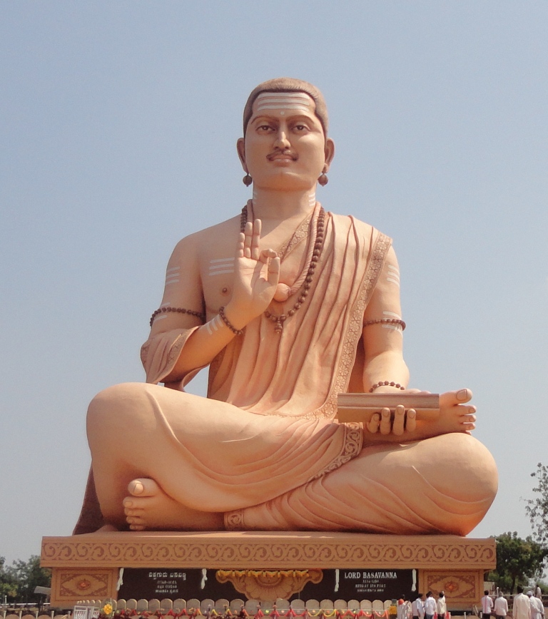
Basavakalyan or Basavakalyana is a historical city and municipal council in the Bidar District of the Indian state of Karnataka. It was the capital of the Kalyani Chalukyas and the Kalachuris of Kalyani. The city is noted for the world's tallest Basavanna statue, which stands 108 feet (33 m) high, and is today one of the major cities and an important industrial hub of Bidar district.
From the Wikipedia article Basavakalyan (this version), under CC BY-SA 4.0.
Museums and landmarks2

Restaurants and cafes2

Churches and places of worship5

Schools, colleges and libraries5

History
Before India's independence, Basavakalyan was called Kalyani. After independence and the division of states on a linguistic basis in 1956, Kalyana was renamed as BasavaKalyan in memory of Basava, a social reformer who established Anubhava Mantapa (spiritual democracy) in 12th-century India.
Basavakalyan was ruled by Western Chalukyas, Kalachuris of Kalyani, Yadavas of Devagiri, Kakatiyas, Delhi Sultanate, Bahamani Sultanate, Bidar Sultanate, Bijapur Sultanate, Mughals and Hyderabad Nizams.
From the History section of Basavakalyan on Wikipedia, under CC BY-SA 4.0.
Healthcare3
Map of Basavakalyan
17 places. The map loads OpenStreetMap tiles when you open it.
Getting there and nearby towns
Bidar Air Force Station (IXX) is the nearest airport with scheduled flights listed in OpenStreetMap, 55 km away.
- Homnābād 22 km southeast, about 22 min by car
- Bhālki 33 km northeast, about 33 min by car
- Nilanga 34 km northwest, about 34 min by car
- Chitaguppa 34 km southeast, about 34 min by car
- Umarga 35 km west, about 35 min by car
- Kamalnagar 46 km northeast, about 46 min by car
- Aland 53 km southwest, about 53 min by car
- Bidar 60 km east, about 1 h by car
- Kalaburagi 61 km south, about 1 h by car
- Latur 71 km northwest, about 1 h 15 min by car
Drive times are estimates from straight-line distance, not routes.
Local news
Headlines from INDB.
Reviews, tips and questions
Loading what members have shared...
Sources and licences
- GeoNames (CC BY 4.0): population, coordinates, regions and time zone
- OpenStreetMap contributors (ODbL 1.0): places, airports, map data
- Wikidata (CC0 1.0): elevation, founding date, time zone, website
- Wikimedia Commons (see each image): photos
- Wikipedia (CC BY-SA 4.0): overview and history text
Photo credits
- Basava Gaint Statue 108 feet, Basava Kalyana, Sscheral, CC BY-SA 3.0
- Basavakalyan Gavimath, Balajijagadesh, CC BY-SA 4.0
- Basava Kalyan Fort, Manjunath Doddamani Gajendragad at en.wikipedia, Public domain
- Akka Nagamma Cave 02, Balajijagadesh, CC BY-SA 4.0
- Akka Nagamma Cave 03, Balajijagadesh, CC BY-SA 4.0
- Akka Nagamma Cave 01, Balajijagadesh, CC BY-SA 4.0
- Akka Nagamma Cave 04, Balajijagadesh, CC BY-SA 4.0
- IslamicFoundationcarrier, IslamicFoundationcarrier Diamond Shine perfect Spoken English, CC BY-SA 4.0
- Akka Nagamma Cave 08, Balajijagadesh, CC BY-SA 4.0
- Akka Nagamma Cave 07, Balajijagadesh, CC BY-SA 4.0
- Akka Nagamma Cave 06, Balajijagadesh, CC BY-SA 4.0
- Akka Nagamma Cave 05, Balajijagadesh, CC BY-SA 4.0
- Akka Nagamma Cave 10, Balajijagadesh, CC BY-SA 4.0
- Akka Nagamma Cave 12, Balajijagadesh, CC BY-SA 4.0
- Akka Nagamma Cave 11, Balajijagadesh, CC BY-SA 4.0
- Akka Nagamma Cave 09, Balajijagadesh, CC BY-SA 4.0
- Shiva temple, Narayanapur, Bidar 393, Balajijagadesh, CC BY-SA 4.0
- Shiva temple, Narayanapur, Bidar 392, Balajijagadesh, CC BY-SA 4.0
- Shiva temple, Narayanapur, Bidar 394, Balajijagadesh, CC BY-SA 4.0
- Shiva temple, Narayanapur, Bidar 395, Balajijagadesh, CC BY-SA 4.0
- Shiva temple, Narayanapur, Bidar 391, Balajijagadesh, CC BY-SA 4.0
- Shiva temple, Narayanapur, Bidar 396, Balajijagadesh, CC BY-SA 4.0
- Shiva temple, Narayanapur, Bidar 267, Balajijagadesh, CC BY-SA 4.0
- Shiva temple, Narayanapur, Bidar 269, Balajijagadesh, CC BY-SA 4.0
- Shiva temple, Narayanapur, Bidar 268, Balajijagadesh, CC BY-SA 4.0
- Shiva temple, Narayanapur, Bidar 266, Balajijagadesh, CC BY-SA 4.0
- Shiva temple, Narayanapur, Bidar 278, Balajijagadesh, CC BY-SA 4.0
- Shiva temple, Narayanapur, Bidar 279, Balajijagadesh, CC BY-SA 4.0
- Shiva temple, Narayanapur, Bidar 280, Balajijagadesh, CC BY-SA 4.0
- Shiva temple, Narayanapur, Bidar 277, Balajijagadesh, CC BY-SA 4.0
- Shiva temple, Narayanapur, Bidar 381, Balajijagadesh, CC BY-SA 4.0
- Shiva temple, Narayanapur, Bidar 380, Balajijagadesh, CC BY-SA 4.0
- Shiva temple, Narayanapur, Bidar 383, Balajijagadesh, CC BY-SA 4.0
- Shiva temple, Narayanapur, Bidar 382, Balajijagadesh, CC BY-SA 4.0
- Shiva temple, Narayanapur, Bidar 306, Balajijagadesh, CC BY-SA 4.0
- Shiva temple, Narayanapur, Bidar 281, Balajijagadesh, CC BY-SA 4.0
- Shiva temple, Narayanapur, Bidar 283, Balajijagadesh, CC BY-SA 4.0
- Shiva temple, Narayanapur, Bidar 285, Balajijagadesh, CC BY-SA 4.0
- Shiva temple, Narayanapur, Bidar 282, Balajijagadesh, CC BY-SA 4.0
- Shiva temple, Narayanapur, Bidar 284, Balajijagadesh, CC BY-SA 4.0


Page built November 3, 2026. Spotted a mistake? Tell us or suggest a place.