


Why visit Hazāribāgh
Townapedia lists 1 museum or landmark, 6 parks and trails, 12 places to eat, 3 places to stay and 1 attraction in and around town.
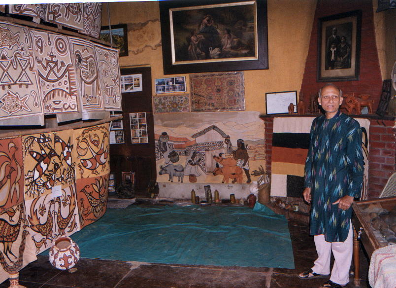
Highlights include Vinoba Bhave University and Sanskriti Museum & Art Gallery.
Weather in Hazāribāgh
Forecast from MET Norway (CC BY 4.0). Full forecast
About Hazāribāgh
Hazaribagh (Hindustani pronunciation: [ɦəzɐ̞ɾɨ.baːɣ]) is a city and a municipal corporation in Hazaribagh district, Jharkhand, India. It is the administrative headquarters of Hazaribagh district and divisional headquarters of North Chotanagpur division. The city is known as a health resort and for the Hazaribagh Wildlife Sanctuary.
From the Wikipedia article Hazaribagh (this version), under CC BY-SA 4.0.
Travel tips from other travellers: Hazāribāgh on Wikivoyage (CC BY-SA 4.0).
Things to do1

Vinoba Bhave University
School · 3.4 km
State public university in Hazaribagh, Jharkhand, India
Museums and landmarks1
Sanskriti Museum & Art Gallery
Museum · 2.5 km
Museum in Hazaribagh, India
Parks, trails and playgrounds6



Restaurants and cafes12



History
In ancient times, the district was covered with forests inhabited by tribes who remained independent. Throughout the Turko-Afghan period, the area remained virtually free from external influence. It was only with the accession of Akbar to the throne of Delhi in 1557 that Muslim influence penetrated Jharkhand, then known to the Mughals as Kokrah. In 1585, Akbar sent a force under the command of Shahbaj Khan to reduce the Raja of Chotanagpur to the position of a tributary.
After the death of Akbar in 1605, the area regained its independence. This necessitated an expedition in 1616 by Ibrahim Khan Fateh Jang, the governor of Bihar and brother of Queen Noorjehan. Ibrahim Khan defeated and captured Durjan Sal, the 46th Raja of Chotanagpur. He was imprisoned for 12 years but was later released and reinstated on the throne after he had shown his ability in distinguishing a real diamond from a fake one.
From the History section of Hazaribagh on Wikipedia, under CC BY-SA 4.0.
Where to stay3
Churches and places of worship5
Shopping3
A.K. Mart
Grocery · 2.0 km
opp Road number 1, near Markham College, Yashwant Nagar
Gas and EV charging2
Schools, colleges and libraries10
St. Xaviers School
School · 1.1 km
Ranchi - Patna Rd, DVC Colony, Hazaribagh, Jharkhand 825301, India, Hazaribagh
Healthcare50
Map of Hazāribāgh
93 places. The map loads OpenStreetMap tiles when you open it.
Getting there and nearby towns
Ranchi Birsa Munda Airport (IXR) is the nearest airport with scheduled flights listed in OpenStreetMap, 75 km away.
- Marāi Kalān 3 km north, about 3 min by car
- Pelāwāl 4 km northwest, about 4 min by car
- Masrātu 4 km west, about 4 min by car
- Meru 11 km east, about 11 min by car
- Charhi 18 km southeast, about 18 min by car
- Taping 22 km southeast, about 22 min by car
- Māndu 25 km southeast, about 25 min by car
- Dari 30 km south, about 30 min by car
- Kedia 32 km southeast, about 32 min by car
- Ranchi 72 km south, about 1 h 15 min by car
Drive times are estimates from straight-line distance, not routes.
Local news
Headlines from INDB.
Reviews, tips and questions
Loading what members have shared...
Sources and licences
- GeoNames (CC BY 4.0): population, coordinates, regions and time zone
- OpenStreetMap contributors (ODbL 1.0): places, airports, map data
- Wikidata (CC0 1.0): elevation, founding date, time zone, website, landmarks and historic places
- Wikimedia Commons (see each image): photos
- Wikipedia (CC BY-SA 4.0): overview and history text
Photo credits
- Sanskritihzb, Gustavimam, CC BY-SA 4.0
- Panch Mandir, Hazaribagh, Jharkhand, Kanad Sanyal, CC BY-SA 4.0
Page built November 2, 2026. Spotted a mistake? Tell us or suggest a place.