




Why visit Jabalpur
Townapedia lists 7 museums and landmarks, 25 parks and trails, 22 places to eat, 12 places to stay and 9 attractions in and around town.
Highlights include Dhuandhar Falls, Gyan Ganga College Of Technology, Rani Durgawati Museum and Madan Mahal Fort.
Weather in Jabalpur
Forecast from MET Norway (CC BY 4.0). Full forecast
About Jabalpur
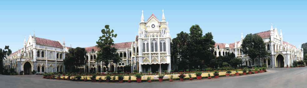
Jabalpur (IPA: [ˈd͡ʐəˌbəlpʊɾ]), formerly anglicised as Jubbulpore, is the fourth largest city by area of the Indian state of Madhya Pradesh. It is situated on the banks of the Narmada River in the state of Madhya Pradesh, India. Jabalpur is the administrative headquarters of the Jabalpur district and the Jabalpur division. The Madhya Pradesh High Court is located in the city.
From the Wikipedia article Jabalpur (this version), under CC BY-SA 4.0.
Travel tips from other travellers: Jabalpur on Wikivoyage (CC BY-SA 4.0).
Things to do9


Gyan Ganga College Of Technology
School · 8.8 km
Engineering college in Madhya Pradesh
Gyan Ganga Institute of Technology & Sciences
School · 8.8 km
GGITS is an institute located in Jabalpur, Madhya Pradesh, India
Hitkarini College of Engineering and Technology
School · 4.8 km
Engineering college in Madhya Pradesh

Shri Ram Institute of Technology
School · 5.4 km
Engineering college in Jabalpur, Madhya Pradesh, India

Tropical Forest Research Institute
School · 8.5 km
Facility in Jabalpur, India


Museums and landmarks7

Rani Durgawati Museum
Museum · 1.7 km
Museum in Madhya Pradesh, India



Mahatma Gandhi Memorial
Monument and historic site · 9.9 km
The sacred bank of Narmada River (Tilwara Ghat) where the ashes of Father of the Nation Mahatma Gandhi were immersed. To preserve his...
Parks, trails and playgrounds25

13 more on the map.
Restaurants and cafes22




10 more on the map.
History
Mythology describes three Asuras (evil spirits) in the Jabalpur region, who were defeated by the Hindu god Shiva. Tripurasura being the main asura, gave the city its puranic name Tripur Tirth. Tripuri region corresponds to the ancient Chedi Kingdom of Mahabharata times, to which king Shishupala belongs.
Ashokan relics dating to 300 BCE have been found in Rupnath, 84 kilometres (52 mi) north of the city, indicating the presence of the Mauryan Empire (322 to 185 BCE) in the region. When the empire fell, Jabalpur became a city-state before coming under the rule of the Satavahana dynasty (230 BCE to 220 CE). After their reign, the region was ruled locally by the Bodhis and the Senas, following which it became a vassal state of the Gupta Empire (320 to 550).
The region was conquered by the Kalachuri Dynasty in 875 CE. The best known Kalachuri ruler was Yuvaraja-Deva I (r. 915–945), who married Nohla Devi (a princess of the Chalukya dynasty). One of the Kalachuri ministers, Golok Simha Kayastha, was instrumental in founding the Chausath Yogini Temple near Bhedaghat. His descendants include Bhoj Simha, who was the Dewan to the Gond king Sangram Shah (1491–1543); Dewan Aadhar Singh Kayastha, who was the prime minister to Rani Durgavati (r. 1550–1564), and Beohar Raghuvir Sinha, the last Jagirdar of Jabalpur who reigned until 1947.
From the History section of Jabalpur on Wikipedia, under CC BY-SA 4.0.
Where to stay12
Hilton Garden Inn Jabalpur
Motel and hotel · 4.8 km
466 Hitkarini Engineering College Road, Priyadarshni Colony, Jabalpur
Patel Hostel
Motel and hotel · 5.9 km
Patel Hostel Gully no. 1 left , Shri Ram College Road, Jabalpur
Churches and places of worship27
Shopping12
Arihant Enterprises
Shopping center · 4.6 km
107 MR 4 Road, Vikas Nagar, Jabalpur
Gas and EV charging3
Schools, colleges and libraries22
Healthcare77
Map of Jabalpur
216 places. The map loads OpenStreetMap tiles when you open it.
Getting there and nearby towns
Jabalpur Airport (JLR) is the nearest airport with scheduled flights listed in OpenStreetMap, 11 km away.
- Amkhera 5 km north, about 5 min by car
- Suhāgi 6 km north, about 6 min by car
- Karmeta 7 km northwest, about 7 min by car
- Mandai 7 km northeast, about 7 min by car
- Vehicle Factory Area Jabalpur 7 km northeast, about 7 min by car
- Bilpura 7 km northeast, about 7 min by car
- Mānegaon 8 km northeast, about 8 min by car
- Khamaria 10 km northeast, about 10 min by car
- Barela 13 km southeast, about 13 min by car
- Panāgar 14 km north, about 14 min by car
Drive times are estimates from straight-line distance, not routes.
Local news
Headlines from INDB.
Reviews, tips and questions
Loading what members have shared...
Sources and licences
- GeoNames (CC BY 4.0): population, coordinates, regions and time zone
- OpenStreetMap contributors (ODbL 1.0): places, airports, map data
- Wikidata (CC0 1.0): elevation, founding date, time zone, website, landmarks and historic places
- Wikimedia Commons (see each image): photos
- Wikipedia (CC BY-SA 4.0): overview and history text
Photo credits
- Chausath-Yogini temple near BhedaGhat, Abhishek Roy, CC BY-SA 3.0
- MP HIGH COURT JABALPUR - panoramio - Gyanendra Singh Chau…, Gyanendra_Singh_Chau…, CC BY 3.0
- MP HIGH COURT JABALPUR - panoramio, Gyanendra_Singh_Chau…, CC BY 3.0
- Night view of Jabalpur during Navratri, Gamerzer, CC BY-SA 4.0
- Garha fatak Mahakali of jabalpur during Navratri, Gamerzer, CC BY-SA 4.0
- Sunarhai devi, jabalpur during Navratri-gamerzer, Gamerzer, CC BY-SA 4.0
- Devi pratyangira at jabalpur - kotwali during Navratri, Gamerzer, CC BY-SA 4.0
- Goddess Durga idol at near madan Mahal, jabalpur during Navratri 2025, Gamerzer, CC BY-SA 4.0
- Idol of Durga with 151 tigers near madan Mahal station jabalpur, madhya pradesh during Navratri, Gamerzer, CC BY-SA 4.0
- Garha fatak(Jabalpur) Mahakali during dussehra chal samaroh, Gamerzer, CC BY-SA 4.0
- The Madan Mahal Fort Jabalpur India,jpg, Sana Syed Ali, CC BY-SA 4.0
- The Madan Mahal Fort Jabalpur Madhya Pradesh India DSC.00023, Sana Syed Ali, CC BY-SA 4.0
- The Madan Mahal Fort Jabalpur Madhya Pradesh India DSC 0005, Sana Syed Ali, CC BY-SA 4.0
- Dhuandhar falls at Bhedaghat, Madhya Pradesh, India, Hariya1234, CC BY 3.0
- Marble Rocks, MP, India, Yann ( talk ), CC BY-SA 4.0
- TFRI main building, Darshank94, CC BY-SA 4.0
- Madan mahal, Chetansoni, CC BY-SA 4.0
- IIITDM Jabalpur Core Lab Complex, and Lecture Hall, Ankitnayak42, CC BY-SA 4.0
- Rani Durgavati Fort, Meghashrimali, CC BY-SA 4.0
- Hq wcr pic, Irss19, CC BY-SA 4.0
- Samdareeya hotel, Getupdateinfotech, CC BY-SA 4.0
- Hitkarini.IMG 1040, Malaiya, CC BY-SA 4.0
- Hitkarini.IMG 1041, Malaiya, CC BY-SA 4.0
- Hitkarini.IMG 1043, Malaiya, CC BY-SA 4.0
- Hitkarini.IMG 1046, Malaiya, CC BY-SA 4.0
- A4988 stepper motor driver, Kushagra Keshari, CC BY-SA 4.0
- Multiple shields stacked on an Arduino board, Kushagra Keshari, CC BY-SA 4.0
- 28BYJ-48 unipolar stepper motor with ULN2003 driver, Kushagra Keshari, CC BY-SA 4.0
- A bipolar stepper motor used in DVD writers, Kushagra Keshari, CC BY-SA 4.0
- Unipolar stepper motor with reduction gear mechanism, Kushagra Keshari, CC BY-SA 4.0
- A bipolar stepper motor with a reduction gear mechanism, Kushagra Keshari, CC BY-SA 4.0
- ULN2003 unioplar stepper motor driver module, Kushagra Keshari, CC BY-SA 4.0
- An N-scale model of EMD E5A "Silver Speed" diesel locomotive, Kushagra Keshari, CC BY-SA 4.0
- DISCIPLINED FEATHERS, Shrikant Bourasia, CC0
- PSX 20191009 190306, Naveensingh18, CC BY-SA 4.0
- Kato C-62 steam, Kushagra Keshari, CC BY-SA 4.0
- Puneet Dixit At Radio Mirchi, Puneet Dixit Music Director, CC BY-SA 3.0
- Celebrate Shakti Utsava, Jabalpur Navratri, CC BY-SA 4.0
- PSX 20191009 191251, Naveensingh18, CC BY-SA 4.0
- Beauty of drops, Disha inwati, CC BY-SA 4.0


Page built November 2, 2026. Spotted a mistake? Tell us or suggest a place.