


Jaipur, India
Jaipur is a regional capital of 3,046,163 people in Rajasthan, India, founded in 1727.
Why visit Jaipur
Townapedia lists 14 museums and landmarks, 37 parks and trails, 128 places to eat, 151 places to stay and 15 attractions in and around town.
Highlights include Biyani Group of Colleges, Indian Institute of Crafts and Design, Amrapali Museum and Albert Hall Museum.
Weather in Jaipur
Forecast from MET Norway (CC BY 4.0). Full forecast
About Jaipur
Jaipur (Rajasthani: Jayapura, pronounced [ˈd͡ʑɛpʊɾᵊ]) is the capital and largest city of the north-western Indian state of Rajasthan. As of 2011, the city had a population of 3.1 million, making it the tenth-most populous city in the country. Located 268 km (167 mi) from the national capital, New Delhi, Jaipur is also known as the Pink City due to the dominant colour scheme of its buildings in the old city.
From the Wikipedia article Jaipur (this version), under CC BY-SA 4.0.
Travel tips from other travellers: Jaipur on Wikivoyage (CC BY-SA 4.0).
Things to do15

Biyani Group of Colleges
School · 4.3 km
Educational institutes in Jaipur, India
Indian Institute of Crafts and Design
School · 5.8 km
Design institution in Jaipur, India
National Institute of Ayurveda
School · 4.7 km
Training and research institute in Ayurveda in Jaipur, India

National Institute of Food Technology, Entrepreneurship and Management, Thanjavur
School · 7.0 km
Higher education institute in Tamil Nadu, India

St Xaviers College, Jaipur
School · 1.0 km
Jesuit college in Jaipur, Rajasthan, India

University of Rajasthan
School · 5.0 km
State public university in Jaipur, Rajasthan, India
Biyani Institute of Science and Management for Girls
School · 4.2 km


Inox City Plaza - Space Cinemas
Cinema and theater · 1.8 km
City Plaza, Pani Pech Meera Marg, Jaipur

3 more on the map.
Museums and landmarks14

Amrapali Museum
Museum · 1.4 km
Museum in Jaipur, India
Ground Floor, K, 14/B, Ashok Marg, Panch Batti, C Scheme, Ashok Nagar, Jaipur, Rajasthan 302001





2 more on the map.
Parks, trails and playgrounds37

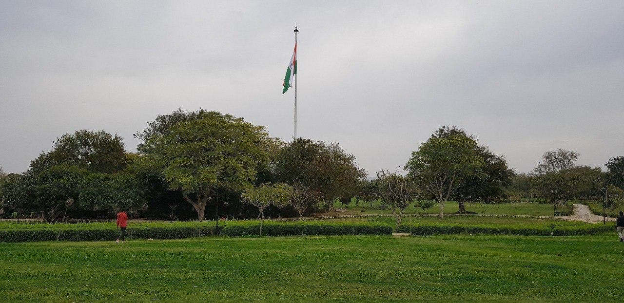


City Park, Jaipur
Park · 7.3 km
Urban park in Jaipur, Rajasthan, India


25 more on the map.
Restaurants and cafes128

Half Light Coffee Roasters
Cafe · Coffee Shop, Sandwich, American, Cake · 1.6 km
Freshly roasted Indian Specialty Coffee Shop and Roastery. Experience Farm to Cup.
F-31 Azad Marg, Jaipur
08:00-22:00

Kalyan Rooftop Restaurant
Restaurant · Italian Pizza, Crepe, Noodles, Asian, Pancake, Italian, Sandwich, Curry, Ice Cream, Local, Mediterranean, Chinese, Tea, Fine Dining, Pizza, Pasta, Indian · 0.9 km
59 hathroi fort Hari Kisham Somani Marg
Mo-Su 07:00-23:50

Café BAE
Cafe · 2.3 km
Breakfast, Continental & Asian fare served in a family-friendly space with outdoor seating.
A/1, 21 Sahkar Marg, Near 22 Godown Circle, C Scheme, Jaipur, Rajasthan 302006
Mo-Su 09:00-22:30
Starbucks
Cafe · Coffee Shop, Coffee · 1.2 km
A-5, Suryavanshi Pearl Chomu House Circle, Jaipur
Mo-Su 09:00-22:00
Copper Chimney
Restaurant · Indian, Asian · 1.6 km
Mirza Ismail Road
Mo-Su 18:30-23:00
Gulab Ji Chai
Cafe · Bun Samosa, Tea · 1.2 km
Mirza Ismail Road, Jaipur
Mo-Su 06:00-20:00

116 more on the map.
History
Jaipur was founded on 18 November 1727 by Jai Singh II, the Kachhwaha Rajput ruler of Amer, who ruled the region from 1699 to 1743. He planned to shift his capital 11 km (7 mi) from Amer to accommodate a growing population and increasing water scarcity. Jai Singh consulted several architects and planned the city based on the principles of Vastu Shastra and Shilpa Shastra, under the architectural guidance of Vidyadhar Bhattacharya. The construction of the city began in 1726. During the rule of Sawai Ram Singh II, the city was painted pink to welcome Albert Edward, Prince of Wales in 1876. Many of the avenues remain painted in pink, giving Jaipur a distinctive appearance and the epithet "Pink City".
In the 19th century, the city grew rapidly, reaching a population of 160,000 by 1900. The wide boulevards were paved, and its chief industries included metalwork and marble, fostered by a school of art founded in 1868. In August 1981, large areas of the city, including the airport, were flooded following heavy rains from a cloudburst, resulting in eight deaths and extensive damage along the Dravyavati River. On 6 July 2019, the city was inscribed on the UNESCO World Heritage List.
From the History section of Jaipur on Wikipedia, under CC BY-SA 4.0.
Where to stay151
Backpackers Headquarter Hostel
Motel and hotel · 1.9 km
B-15 Gopinath Marg, Purohit Ji ka bhag
Churches and places of worship19
temple hindu
Place of worship · 2.5 km
VQWP+MGJ, Hawa Sadak, Sharma Colony, Bais Godam, Jaipur, Rajasthan 302006
Shopping17
"Pandey Moorti Kala Kendra", "Pandey Moorti Bhandar", "Pandey Exports"
Shop · 2.6 km
1399 Khejron Ka Rasta, Jaipur
Vishal
Grocery · 1.3 km
Plot No, 1, Elevated Ajmer Rd, opposite Government hostel, Gopalbari, Jaipur, Rajasthan 302006 Ajmer Road, Jaipur
Gas and EV charging18
Schools, colleges and libraries30
ad ground
School · 2.2 km
WR65+XXF, Bhagwan Das Rd, Panch Batti, C Scheme, Ashok Nagar, Jaipur, Rajasthan 302001
Government Senior Secondary School Sodala
School · 2.8 km
Ajmer Road, Sodala, Jaipur
New Pupils Senior Secondary School
School · 2.7 km
2976 uniyaro ka rasta, 3rd cross
St xavier sec school
School · 2.2 km
WR65+XXF, Bhagwan Das Rd, Panch Batti, C Scheme, Ashok Nagar, Jaipur, Rajasthan 302001
Healthcare156
Map of Jaipur
250 places. The map loads OpenStreetMap tiles when you open it.
Getting there and nearby towns
Jaipur International Airport (JAI) is the nearest airport with scheduled flights listed in OpenStreetMap, 11 km away.
- Ākera 10 km north, about 10 min by car
- Bagrāna 15 km east, about 15 min by car
- Kānota 17 km east, about 17 min by car
- Jamwa Rāmgarh 25 km northeast, about 25 min by car
- Bagru 27 km southwest, about 27 min by car
- Basi 28 km east, about 28 min by car
- Chaumu 29 km north, about 29 min by car
- Bānskhoh 37 km east, about 37 min by car
- Chaksu 38 km southeast, about 38 min by car
- Jobner 40 km west, about 40 min by car
Drive times are estimates from straight-line distance, not routes.
Local news
Headlines from INDB.
Reviews, tips and questions
Loading what members have shared...
Sources and licences
- GeoNames (CC BY 4.0): population, coordinates, regions and time zone
- OpenStreetMap contributors (ODbL 1.0): places, airports, map data
- Wikidata (CC0 1.0): elevation, founding date, time zone, website, landmarks and historic places
- Wikimedia Commons (see each image): photos
- Wikipedia (CC BY-SA 4.0): overview and history text
Photo credits
- Jaipur Junction railway station - 4, This illustration was made by Peter Potrowl . Please credit this with : © Peter Potrowl in the immediate vicinity of the image. A link to my website sitemai.eu would be much appreciated but isn't..., CC BY-SA 4.0
- Jaipur Junction railway station - 1, This illustration was made by Peter Potrowl . Please credit this with : © Peter Potrowl in the immediate vicinity of the image. A link to my website sitemai.eu would be much appreciated but isn't..., CC BY-SA 4.0
- Jaipur Junction railway station - 3, This illustration was made by Peter Potrowl . Please credit this with : © Peter Potrowl in the immediate vicinity of the image. A link to my website sitemai.eu would be much appreciated but isn't..., CC BY-SA 4.0
- Jaipur Junction railway station - 5, This illustration was made by Peter Potrowl . Please credit this with : © Peter Potrowl in the immediate vicinity of the image. A link to my website sitemai.eu would be much appreciated but isn't..., CC BY-SA 4.0
- Jaipur Junction railway station - 6, This illustration was made by Peter Potrowl . Please credit this with : © Peter Potrowl in the immediate vicinity of the image. A link to my website sitemai.eu would be much appreciated but isn't..., CC BY-SA 4.0
- Jaipur Junction railway station - 2, This illustration was made by Peter Potrowl . Please credit this with : © Peter Potrowl in the immediate vicinity of the image. A link to my website sitemai.eu would be much appreciated but isn't..., CC BY-SA 4.0
- Jaipur S Gate, Alexandre Ultré, CC BY-SA 3.0
- Jaipur, most metra, I would appreciate being notified if you use my work outside Wikimedia. More of my work can be found in my personal gallery ., CC BY-SA 4.0
- Elephant festivel The Elephant Festival is a unique event of the elephants organized on the eve of Holi in Jaipur, the capital of Rajasthan, India - panoramio, pradeep kumar chatte…, CC BY 3.0
- Jaipur - Sheraton view on the street - panoramio, BlackNose, CC BY 3.0
- YDM4-6669 Jaipur Junction, 2008 (1), Bahnfrend, CC BY-SA 3.0
- WDM2-16839 Jaipur Junction, 2008 (1), Bahnfrend, CC BY-SA 3.0
- YDM4-6669 Jaipur Junction, 2008 (3), Bahnfrend, CC BY-SA 3.0
- YDM4-6669 Jaipur Junction, 2008 (2), Bahnfrend, CC BY-SA 3.0
- WDM3A-16276R Jaipur Junction, 2008 (2), Bahnfrend, CC BY-SA 3.0
- WDM3A-16276R Jaipur Junction, 2008 (1), Bahnfrend, CC BY-SA 3.0
- WDM2-16839 Jaipur Junction, 2008 (2), Bahnfrend, CC BY-SA 3.0
- Department of Sanskrit, University of Rajasthan, Arjuncm3, CC BY-SA 3.0
- AMRAPALI MUSEUM, JAIPUR, Neek-Theri, CC BY-SA 4.0
- 2022 July - JawaharKalaKendra Jaipur 13, Chainwit., CC BY-SA 4.0
- Peacock the beauty, ANUBHABAMAL3009, CC BY-SA 4.0
- City Park Jaipur View, Mukesh.kfc, CC BY 4.0
- Albert Hall museum, Jaipur, Anjaliup79, CC BY-SA 4.0
- Bissau Palace, Hari Singh from Ilford, Essex, UK, CC BY 2.0
- Raj Mandir Cinema, Jaipur 01, Antoine Taveneaux, CC BY-SA 3.0
- NIFTEM, Chathirathan, CC BY-SA 3.0
- Sxcjpr, Editm497, CC BY-SA 4.0
- Central Park of Jaipur, Akku09102004, CC BY-SA 4.0
- Nahargarh Fort view, vsvinaykumar, Attribution
- The elephant festival. - panoramio (10), pradeep kumar chatte…, CC BY 3.0
- Flower in Forest 2, कृष्ण कान्त शर्मा, CC BY-SA 4.0
- Flower in Forest, कृष्ण कान्त शर्मा, CC BY-SA 4.0
- Deer in Forest, कृष्ण कान्त शर्मा, CC BY-SA 4.0
- Ranthambhor National Park Safari IMG 3103, कृष्ण कान्त शर्मा, CC BY-SA 4.0
- Deer in Forest M1, कृष्ण कान्त शर्मा, CC BY-SA 4.0
- Deer in Forest 01, कृष्ण कान्त शर्मा, CC BY-SA 4.0
- Deer in Forest M2, कृष्ण कान्त शर्मा, CC BY-SA 4.0
- JPSFATJP, Sranjanm2002, CC BY-SA 3.0
- रंगीलो म्हारो देस, akshatsgi, CC BY-SA 4.0
- Pulitzer Prize-Winning Novelist and Short Story Writer Junot Diaz Speaks With a Fan (5393624464), U.S. Department of State from United States, Public domain
- Lascar City Palace (Jaipur) (4499868946), Jorge Láscar from Australia, CC BY 2.0
- Ajmeri Gate - Japiur (2022) - img 03, Chainwit., CC BY 4.0


Page built November 2, 2026. Spotted a mistake? Tell us or suggest a place.