


Why visit Kanhangad
Townapedia lists 9 museums and landmarks, 22 parks and trails, 72 places to eat, 23 places to stay and 7 attractions in and around town.
Highlights include Kannur University and Hosdurg Fort.
Weather in Kanhangad
Forecast from MET Norway (CC BY 4.0). Full forecast
About Kanhangad
Kanhangad (Malayalam: [kaːɲːɐŋːaːɖɨ̆] ) is a city and municipality, located in the Kasaragod district, state of Kerala, India. It is the most populous city in Kasaragod district.
From the Wikipedia article Kanhangad (this version), under CC BY-SA 4.0.
Travel tips from other travellers: Kanhangad on Wikivoyage (CC BY-SA 4.0).
Things to do7
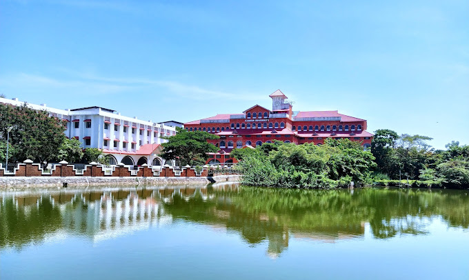
Kannur University
School · 7.7 km
State public university in Kannur, Kerala, India

Museums and landmarks9




Parks, trails and playgrounds22



10 more on the map.
Restaurants and cafes72


Neelgiri restairant
Restaurant · Regional · 2.6 km
Kasargod-Kannur-Calicut Highway

60 more on the map.
History
It was cited in old folklore that the area of Kanhangad was under the reign of king Nanda Raja of Mushaka Rajya, headquartered in Ezhimala Kannur region during the Sangam period. The historic region was known as Poozhinadu and later Paduvanadu. However, the history of Kanhangad can be clearly understood only by the 8th century. During this period the area was a part of the 2nd Chera Dynasty. The illustrations of a Chera King, Bhaskaran Ravi Varman II obtained from Pullur shows the political sovereignty of the Chera Kingdom in this region.
Later, when Kolathunadu of Kolathiri dynasty from Kannur administered the region, Kolathiri appointed Kanhan as the baron of the region. So the name Kanhante Naadu, meaning 'Kanhan's Province' contracted to Kanhangad.
Due to the collapse of the Kolathiri Dynasty, the reign of Elamkoor came to an end and the powerful elite barons renowned as Ettadukkal lords gained the strength. Among them, the mightiest was Allohalan, whose reign was concentrated around Madiyan Kovilakam. With the help of the Zamorin, Kolathiri has assassinated him and established a new dynasty at Neeleswaram headquarters. Earlier Kanhangad was a crucial port in all sense. Hence the Vijayanagara kings attacked Kanhangad too during their conquest of Tulu Nadu. After the fall of the Vijayanagara dynasty, the Ikkeri Kings have been attacking this area since the 1630s.
From the History section of Kanhangad on Wikipedia, under CC BY-SA 4.0.
Where to stay23
Churches and places of worship90
Arayalingal Vishnumoorthi Temple
Place of worship · Hindu · 0.8 km
Arayi, Kanhangad
Arayi Kovilakam bhagavathi kshethram
Place of worship · Hindu · 0.8 km
Arayi, Kanhangad
Arayi Sree Erathu Mundya Temple
Place of worship · Hindu · 1.1 km
Neeleswaram-Chayyoth-Arayi, Kanhangad
sree dharma shastha kshethram
Place of worship · 4.6 km
Hosdurg - Panathur Road, Ajanur
Valiyaveedu Tharavad
Place of worship · Hindu · 1.0 km
Neeleswaram-Chayyoth-Arayi, Kanhangad
Mathoth Shri MahaVishnu Temple
Place of worship · 1.3 km
Kasaragod - Kanhangad Road, KANHANGAD SOUTH
Shopping34
Gas and EV charging5
Schools, colleges and libraries80
Government Higher Secondary School, Kakkat
School · 5.2 km
Neeleswaram-Chayyoth-Arayi
Little Flower Girls Higher Secondary School, Kanhangad
School · 1.5 km
Kasaragod - Kanhangad Road
Government Lower Primary School, Hosdurg Theruvath
School
Theruvathu Road, Theruvathu
Government Upper Primary School, Arayi
School · 1.1 km
Neeleswaram-Chayyoth-Arayi, Kanhangad
Healthcare47
Shashirekha Hospital
Hospital · 3.0 km
Kushavana Kunnu Kottacherry-Mavungal Road, Kanhangad
kanhangad Deepa nursing home
Hospital · 2.3 km
Kailas-Railway Stn;Kottacherry-RlyStn Rd., Kanhangad
Krishna Nursing Home
Hospital · 2.8 km
Kottacherry-Mavungal Road, Kanhangad Muncipality
Map of Kanhangad
250 places. The map loads OpenStreetMap tiles when you open it.
Getting there and nearby towns
Kannur International Airport (CNN) is the nearest airport with scheduled flights listed in OpenStreetMap, 64 km away.
- Ajānūr 3 km northwest, about 3 min by car
- Nīlēshwar 6 km southeast, about 6 min by car
- Perole 7 km southeast, about 7 min by car
- Kīkāna 10 km northwest, about 10 min by car
- Pallikere 13 km northwest, about 13 min by car
- Pilikōdu 14 km southeast, about 14 min by car
- Bāre 17 km northwest, about 17 min by car
- Māriyāt 16 km southeast, about 16 min by car
- Karuvellūr 17 km southeast, about 17 min by car
- Uduma 17 km northwest, about 17 min by car
Drive times are estimates from straight-line distance, not routes.
Local news
Headlines from INDB.
Reviews, tips and questions
Loading what members have shared...
Sources and licences
- GeoNames (CC BY 4.0): population, coordinates, regions and time zone
- OpenStreetMap contributors (ODbL 1.0): places, airports, map data
- Wikidata (CC0 1.0): elevation, founding date, time zone, website, landmarks and historic places
- Wikimedia Commons (see each image): photos
- Wikipedia (CC BY-SA 4.0): overview and history text
Photo credits
- Kanhangad Town, ARUNKUMAR P.R, CC BY-SA 3.0
- 12306 GLPS HOSDURG THERUVATH KANHANGAD PXL 20250920 034342115, Vijayanrajapuram, CC BY-SA 4.0
- District hospital Kanhangad (93350), Ajeeshkumar4u, CC BY-SA 4.0
- District hospital Kanhangad (17185), Ajeeshkumar4u, CC BY-SA 4.0
- District hospital Kanhangad (59959), Ajeeshkumar4u, CC BY-SA 4.0
- District hospital Kanhangad (72355), Ajeeshkumar4u, CC BY-SA 4.0
- District hospital Kanhangad (27738), Ajeeshkumar4u, CC BY-SA 4.0
- District hospital Kanhangad, Ajeeshkumar4u, CC BY-SA 4.0
- Kanhangad, Kerala, India. (4804997740), Shareef Taliparamba, CC BY-SA 2.0
- Kannur Univerisity Thavakkara Campus, Rahul B Ashok, CC0
- Hosdurg fort vijayan rajapuram, Vijayanrajapuram, CC BY-SA 4.0
- 12306 GLPS Hosdurg Theruvath PXL 20250920 034334296 01, Vijayanrajapuram, CC BY-SA 4.0
- 12306 GLPS Hosdurg Theruvath PXL 20250920 034334296 02, Vijayanrajapuram, CC BY-SA 4.0
- 12306 GLPS Hosdurg Theruvath PXL 20250920 034334296 03, Vijayanrajapuram, CC BY-SA 4.0
- Banana 1, Vijayanrajapuram, CC BY-SA 4.0
- Pottan theyyam 5, Vijayanrajapuram, CC BY-SA 4.0
- Dregea volubilis 05, Vijayanrajapuram, CC BY-SA 4.0
- Dregea volubilis -flower bunch, Vijayanrajapuram, CC BY-SA 4.0
- Dregea volubilis flowers, Vijayanrajapuram, CC BY-SA 4.0
- Wattakaka volubilis flower, Vijayanrajapuram, CC BY-SA 4.0
- Dregea volubilis plant, Vijayanrajapuram, CC BY-SA 4.0
- Pen knife, Vijayanrajapuram, CC BY-SA 4.0
- Pen knife3, Vijayanrajapuram, CC BY-SA 4.0
- Pen knife2, Vijayanrajapuram, CC BY-SA 4.0
- Mortuary instructions kerala 01, Vijayanrajapuram, CC BY-SA 4.0
- Nithyananda Ashram (4601209898), Shareef Taliparamba, CC BY-SA 2.0
- Vishnu Moorthi (2), Vaikoovery, CC BY 3.0
- Cheralath Bhagavathi (2), Vaikoovery, CC BY 3.0
- Chamundi (6), Vaikoovery, CC BY 3.0
- Cheralath Bhagavathi (4), Vaikoovery, CC BY 3.0
- Patarkulangara Bhagavathi (5), Vaikoovery, CC BY 3.0
- Cheralath Bhagavathi (6), Vaikoovery, CC BY 3.0
- Poomaruthan (5), Vaikoovery, CC BY 3.0
- Patarkulangara Bhagavathi (1), Vaikoovery, CC BY 3.0
- Chamundi (5), Vaikoovery, CC BY 3.0
- Chamundi (11), Vaikoovery, CC BY 3.0
- Patarkulangara Bhagavathi (4), Vaikoovery, CC BY 3.0
- Cheralath Bhagavathi (11), Vaikoovery, CC BY 3.0
- Chamundi (2), Vaikoovery, CC BY 3.0
- Patarkulangara Bhagavathi (2), Vaikoovery, CC BY 3.0


Page built November 2, 2026. Spotted a mistake? Tell us or suggest a place.