
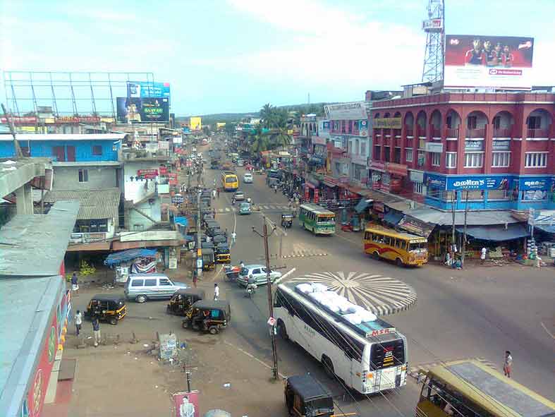


Why visit Kondotty
Townapedia lists 2 museums and landmarks, 6 parks and trails, 17 places to eat, 2 places to stay and 2 attractions in and around town.
Highlights include Moyinkutty Vaidyar Memorial.
Weather in Kondotty
Forecast from MET Norway (CC BY 4.0). Full forecast
About Kondotty
Kondotty (Malayalam: [koɳɖoːʈːi]) is a town and municipality in the Malappuram district in the state of Kerala, India, located near Calicut International Airport, 24 km from Malappuram. It is the headquarters of Kondotty Taluk, which was declared as the seventh taluk in Malappuram district by chief minister Oommen Chandy on 23 December 2013, Real Malabar F.C is professional football club from Kondotty and FC Kondotty is the only All India Sevens Football club from Kondotty.
From the Wikipedia article Kondotty (this version), under CC BY-SA 4.0.
Travel tips from other travellers: Kondotty on Wikivoyage (CC BY-SA 4.0).
Things to do2

Museums and landmarks2



Parks, trails and playgrounds6



Restaurants and cafes17

Arabian Majlis, Kondotty
Restaurant · Barbecue, Arab · 2.2 km
Arabian Majlis Calicut-Malappuram-Palakkad Highway, Thurakkal - Kondotty
Mo-Su 12:00-23:00

5 more on the map.
History
The history of Kondotty is connected with that of the 18th century Kondotty Thangals, the Sufi exponents. Tipu Sultan of Mysore brought the first Thangal Muhammad Shah, to make the Mappilas allies. The Thangal first resided at Areekode and later settled in Kondotty. When the British arrived, putting an end to the reign of Tipu Sultan, the Thangal realigned with the British. During the 1921 upsurge, the Mappila mob attacked the house of the seventh Thangal, Nasiruddin Shah.
Nediyiruppu is 2 km from Kondotty. It is from where the Zamorin kingdom was expanded. During the ancient times, Zamorins were known as Nediyiruppu Swaroopams.
From the History section of Kondotty on Wikipedia, under CC BY-SA 4.0.
Where to stay2
Churches and places of worship8
Shopping2
4p Mart Supermarket
Grocery · 0.7 km
kondotty Calicut-Malappuram-Palakkad Highway NH 966, kondotty
Gas and EV charging7
Schools, colleges and libraries33
Airport School Calicut
School · 2.2 km
Thenhipalam - Puthur Pallikkal - Airport Road
Al-Huda Higher Secondary School Kariyanakkallu
School · 3.1 km
Pallickal, Kondotty
Healthcare21
Relief Hospital And Trauma Centre (Joint Replacement Centre) Bypass Road Kondotty
Hospital
Kozhikkode - Palakkad Road
Zybba Life Care Surgicals And Implants
Clinic and pharmacy
Calicut-Malappuram-Palakkad Highway NH 966
government medical hospital
Hospital · 1.1 km
Calicut-Malappuram-Palakkad Highway NH 966, kondotty
Map of Kondotty
100 places. The map loads OpenStreetMap tiles when you open it.
Getting there and nearby towns
Calicut International Airport (CCJ) is the nearest airport with scheduled flights listed in OpenStreetMap, 1 km away.
- Tirūrangādi 12 km southwest, about 12 min by car
- Mavoor 15 km north, about 15 min by car
- Malappuram 17 km southeast, about 17 min by car
- Kōttakkal 16 km south, about 16 min by car
- Manjeri 17 km east, about 17 min by car
- Kunnamangalam 20 km northwest, about 20 min by car
- Kozhikode 23 km northwest, about 23 min by car
- Tirur 26 km south, about 26 min by car
- Nilambūr 32 km northeast, about 32 min by car
- Perintalmanna 34 km southeast, about 34 min by car
Drive times are estimates from straight-line distance, not routes.
Local news
Headlines from INDB.
Reviews, tips and questions
Loading what members have shared...
Sources and licences
- GeoNames (CC BY 4.0): population, coordinates, regions and time zone
- OpenStreetMap contributors (ODbL 1.0): places, airports, map data
- Wikidata (CC0 1.0): elevation, founding date, time zone, website, landmarks and historic places
- Wikimedia Commons (see each image): photos
- Wikipedia (CC BY-SA 4.0): overview and history text
Photo credits
- Kondotty Town-Main Junction, Moidu.babu, CC BY-SA 4.0
- Mulanthuruthymarthomanchurch, Kokkarani, CC BY-SA 3.0
- Vaidyar, Nmkuttiady, CC BY-SA 3.0
- Rainy Leaf, Abypaul, CC BY-SA 4.0
- Frost in Malappuram Mini Ooty, Jemshad.A, CC BY-SA 4.0
- Calicut International Airport, Gannu03, CC BY-SA 3.0
- Manoj's Visit at Moyinkutty Vaidyar Smarakam and CH Chair for Arabimalayalam 04, Manojk, CC BY-SA 4.0
- Manoj's Visit at Moyinkutty Vaidyar Smarakam and CH Chair for Arabimalayalam 06, Manojk, CC BY-SA 4.0
- Manoj's Visit at Moyinkutty Vaidyar Smarakam and CH Chair for Arabimalayalam 07, Manojk, CC BY-SA 4.0
- Manoj's Visit at Moyinkutty Vaidyar Smarakam and CH Chair for Arabimalayalam 05, Manojk, CC BY-SA 4.0
- Calicut International Airport inside vrtmrgmpksk (3), Vinayaraj, CC BY-SA 4.0
- Calicut International Airport inside vrtmrgmpksk (2), Vinayaraj, CC BY-SA 4.0
- Calicut International Airport inside vrtmrgmpksk (4), Vinayaraj, CC BY-SA 4.0
- Calicut International Airport inside vrtmrgmpksk (1), Vinayaraj, CC BY-SA 4.0
- Parking bay, Faizvvk, CC BY-SA 4.0
- Calicut International Airport inside vrtmrgmpksk (5), Vinayaraj, CC BY-SA 4.0
- Calicut International Airport inside vrtmrgmpksk (6), Vinayaraj, CC BY-SA 4.0
- Calicut International Airport inside vrtmrgmpksk (8), Vinayaraj, CC BY-SA 4.0
- Calicut International Airport inside vrtmrgmpksk (7), Vinayaraj, CC BY-SA 4.0
- Calicut International Airport inside vrtmrgmpksk (9), Vinayaraj, CC BY-SA 4.0
- Etihad Calicut, Faizvvk, CC BY-SA 4.0
- കൃഷ്ണ കിരീടം പുഷ്പം, Drnisamudheen, CC BY-SA 4.0


Page built November 3, 2026. Spotted a mistake? Tell us or suggest a place.