


Why visit Kuttippuram
Townapedia lists 9 parks and trails, 20 places to eat, 14 places to stay and 2 attractions in and around town.
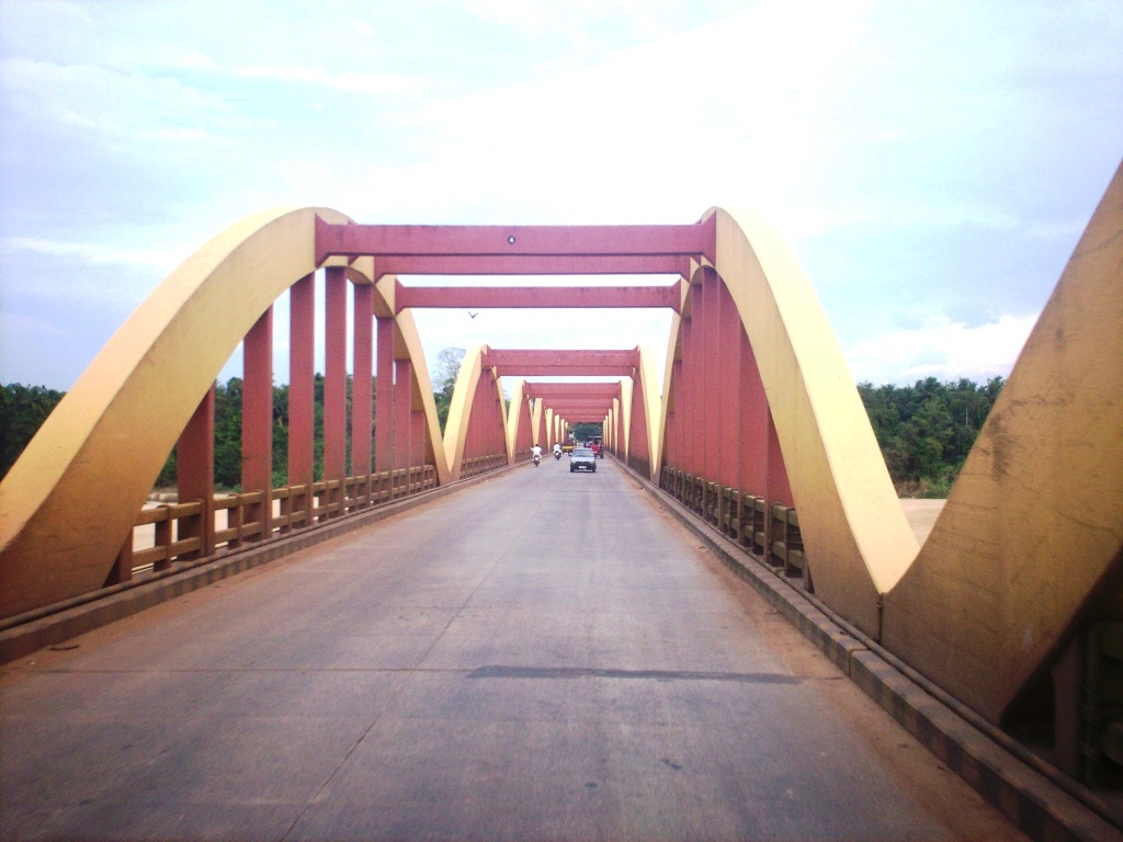
Highlights include Kuttippuram bridge.
Weather in Kuttippuram
Forecast from MET Norway (CC BY 4.0). Full forecast
About Kuttippuram
Kuttippuram is a town and a block headquarters, situated in the Tirur Taluk, Malappuram district of Kerala state, India. The town is located 34 kilometres south-west of Malappuram and 8 kilometres west of Valanchery. The Bharathappuzha river flows through Kuttippuram. According to the last Census of India conducted in 2011, Kuttippuram forms a part of the Malappuram metropolitan area.
From the Wikipedia article Kuttippuram (this version), under CC BY-SA 4.0.
Things to do2



Parks, trails and playgrounds9



Restaurants and cafes20

Arabian Food City
Restaurant
Kuttippuram Bus Station Road, Kuttippuram Town
Mo-Sa 09:00-20:00

Bombay Bakery
Bakery
Kuttippuram Malloorkadavu Road, Kuttippuram
Mo-Sa 09:00-20:00
Nehal Bakes
Bakery
Nehal Bakes Kuttippuram Tirur Road, Kuttippuram
Mo-Su 09:00-20:00

8 more on the map.
Where to stay14

2 more on the map.
History
Kuttippuram, on the northern bank of the river Bharathappuzha, was ruled by the Zamorin of Calicut during the middle ages. Kuttippuram railway station is one of the oldest railway stations in Kerala. The second railway line in Kerala was laid from Tirur to Kuttippuram in 1861, as an extension of the first line laid from Tirur to Beypore in the same year. In the 1940s, several national leaders including C. Rajagopalachari, M. Bhaktavatsalam, and Yakkob Hassan visited Kuttippuram. Fakhruddin Ali Ahmed, a former president of India, has also visited here. The ashes of Mahatma Gandhi, Jawaharlal Nehru, and Lal Bahadur Shastri, were deposited in Kerala between Tirunavaya, Kuttippuram, and Thavanur, on the bank of the river Bharathappuzha.
The Kuttippuram bridge, built in 1953, is one of the famous bridges in Kerala. The poem Kuttippuram Palam, describing the beauty of Bharathappuzha River at the sandy riverbank of Kuttippuram, was written by the poet Edasseri Govindan Nair. Kuttippuram was also a constituency of the Kerala Legislative Assembly from 1957 to 2011, which was then replaced by the Kottakkal constituency.
Tirunavaya, the centre of medieval Mamankam festival, and Athavanad, which was the centre of Azhvanchery Thamprakkal, lie adjacent to Kuttippuram.
From the History section of Kuttippuram on Wikipedia, under CC BY-SA 4.0.
Churches and places of worship25
Masjid Tawheed
Place of worship · Sunni · 1.5 km
Perasannur Road, Ashpathripadi, Kuttippuram
Padikkal Subramanian Temple, Kadakassery
Place of worship · 3.8 km
Kadakassery, Thavanur
Painkanoor Shiva Temple
Place of worship · 4.0 km
Valanchery-Kuttipuram-Ponani Highway
Shopping7
Gas and EV charging6
Schools, colleges and libraries62
A Lower Primary School Thrikkanapuram
School · 2.0 km
Thrissur – Kuttippuram Road, Thavannur
Government High Secondary School Anakkara
School · 3.6 km
Anakkara-Edappal Road, Palakkad
Healthcare21
Changampally Ayurveda Vidya Sala
Clinic and pharmacy
Kuttippuram Malloorkadavu Road
Community Health Center Kuttippuram
Hospital · 1.4 km
Police Station Road, Kuttippuram
Map of Kuttippuram
166 places. The map loads OpenStreetMap tiles when you open it.
Getting there and nearby towns
Calicut International Airport (CCJ) is the nearest airport with scheduled flights listed in OpenStreetMap, 34 km away.
- Ponnāni 14 km southwest, about 14 min by car
- Tirur 14 km northwest, about 14 min by car
- Katavallūr 15 km south, about 15 min by car
- Pattāmbi 17 km east, about 17 min by car
- Malappuram 23 km north, about 23 min by car
- Tirūrangādi 25 km northwest, about 25 min by car
- Perintalmanna 26 km northeast, about 26 min by car
- Shōranūr 28 km east, about 28 min by car
- Cheruthuruthi 29 km east, about 29 min by car
- Manjeri 32 km north, about 32 min by car
Drive times are estimates from straight-line distance, not routes.
Local news
Headlines from INDB.
Reviews, tips and questions
Loading what members have shared...
Sources and licences
- GeoNames (CC BY 4.0): population, coordinates, regions and time zone
- OpenStreetMap contributors (ODbL 1.0): places, airports, map data
- Wikidata (CC0 1.0): elevation, founding date, time zone, website, landmarks and historic places
- Wikimedia Commons (see each image): photos
- Wikipedia (CC BY-SA 4.0): overview and history text
Photo credits
- Kuttippuram, Kerala,India, Prof tpms, CC BY-SA 4.0
- MESCE Kuttippuram, Praveenp at Malayalam Wikipedia, CC BY-SA 3.0
- Kuttippuram railway station uploads by vijayanrajapuram 07, Vijayanrajapuram, CC BY-SA 4.0
- Kuttippuram railway station uploads by vijayanrajapuram 08, Vijayanrajapuram, CC BY-SA 4.0
- Kuttippuram railway station uploads by vijayanrajapuram 05, Vijayanrajapuram, CC BY-SA 4.0
- Kuttippuram railway station uploads by vijayanrajapuram 06, Vijayanrajapuram, CC BY-SA 4.0
- Kuttippuram railway station uploads by vijayanrajapuram 02, Vijayanrajapuram, CC BY-SA 4.0
- Kuttippuram railway station uploads by vijayanrajapuram 01, Vijayanrajapuram, CC BY-SA 4.0
- Kuttippuram railway station uploads by vijayanrajapuram 04, Vijayanrajapuram, CC BY-SA 4.0
- Kuttippuram railway station uploads by vijayanrajapuram 03, Vijayanrajapuram, CC BY-SA 4.0
- Kuttippuram Railway station vrvbaan042k24 (2), Vinayaraj, CC BY-SA 4.0
- Kuttippuram Railway station vrvbaan042k24 (3), Vinayaraj, CC BY-SA 4.0
- Kuttippuram Railway station vrvbaan042k24 (1), Vinayaraj, CC BY-SA 4.0
- Kuttippuram Railway station vrvbaan042k24, Vinayaraj, CC BY-SA 4.0
- Kuttippuram railway station, Sujithshivam511, CC BY-SA 4.0
- Kuttippuram Railway station (15600), Sujithshivam511, CC BY-SA 4.0
- Kuttippuram Bridge on Bharathappuzha at Mini Pamba, Vijayanrajapuram, CC BY-SA 4.0
- Kuttippuram Railway Station 2, Gnoeee, CC BY-SA 4.0
- Kuttippuram palam-, Vicharam, CC BY-SA 4.0
- Kuttippuram Railway Station 1, Gnoeee, CC BY-SA 4.0
- Bharathappuzha kuttippuram vijayanrajapuram, Vijayanrajapuram, CC BY-SA 4.0
- Kuttippuram 1, Emilien Lebourgeois, Public domain
- Kuttippuram Bridge over Bharathappuzha at Mini Pamba, Vijayanrajapuram, CC BY-SA 4.0
- Sunset at Kuttippuram, Kerala, Praveenp, CC BY-SA 3.0
- Bridge -bharatappuzha -kuttippuram (1), Sajetpa at Malayalam Wikipedia, CC BY-SA 3.0
- Flower1163, സുനിൽ ദേവ്, CC BY-SA 4.0
- White Fabaceae flowers in India (2016), സുനിൽ ദേവ്, CC BY-SA 4.0
- Mallur Siva Temple Mini pamba vijayanrajapuram1, Vijayanrajapuram, CC BY-SA 4.0
- Mallur Siva Temple Mini pamba vijayanrajapuram2, Vijayanrajapuram, CC BY-SA 4.0
- Mallur Siva Temple Mini pamba vijayanrajapuram3, Vijayanrajapuram, CC BY-SA 4.0
- T K Padmini auditorium Mini pamba vijayanrajapuram 02, Vijayanrajapuram, CC BY-SA 4.0
- T K Padmini auditorium Mini pamba vijayanrajapuram 01, Vijayanrajapuram, CC BY-SA 4.0
- Cheilocostus speciosus 8, Vengolis, CC BY-SA 3.0
- Oriental Magpie Robin (M) മണ്ണാത്തിപ്പുള്ള് (ആൺ), Arun.arunb, CC BY-SA 4.0
- Blossom-headed parakeet, Arun.arunb, CC BY-SA 4.0
- Crested Serpent Eagle - Juvenile, Arun.arunb, CC BY-SA 4.0
- Stork billed Kingfisher, Arun.arunb, CC BY 4.0
- Panniyur Varahamoorthy temple, Kumbidi Kerala 20210707, K.faseela, CC BY-SA 4.0
- Vadakkath mana 2, Vicharam, CC BY-SA 4.0
- Vadakkath mana, Vicharam, CC BY-SA 4.0


Page built November 3, 2026. Spotted a mistake? Tell us or suggest a place.