


Why visit Orchha
Townapedia lists 13 museums and landmarks, 1 park or trail, 14 places to eat, 20 places to stay and 2 attractions in and around town.
Highlights include Chhatris and Orchha Fort.
Weather in Orchha
Forecast from MET Norway (CC BY 4.0). Full forecast
About Orchha
Orchha is a city near the city of Niwari in the Niwari district of Madhya Pradesh state, India. The city was established by a Bundela Rajput ruler Rudra Pratap Singh some time after 1501, as the seat of an eponymous former princely state including parts of central and north India, in the Bundelkhand region. Orchha lies on the Betwa River, 126 km from Gwalior, 89 km from Tikamgarh and 18 km from Jhansi in Uttar Pradesh.
From the Wikipedia article Orchha (this version), under CC BY-SA 4.0.
Travel tips from other travellers: Orchha on Wikivoyage (CC BY-SA 4.0).
Things to do2

Museums and landmarks13



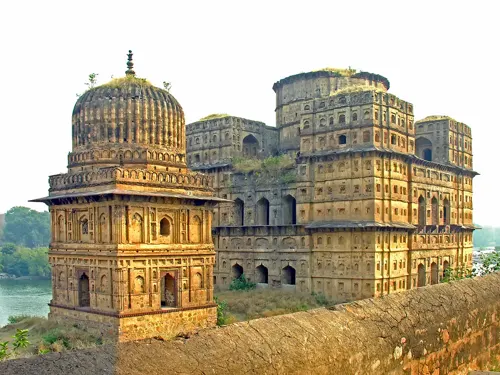


1 more on the map.
Parks, trails and playgrounds1

Restaurants and cafes14

Cafe No-Mads
Restaurant · Mediterranean, Tea, Chinese, Pizza, Burger, Pasta, Breakfast, Indian
Main Road near River
Mo-Su 08:30-22:00
Ram Raja Restaurant & Cafe
Restaurant · Indian, Breakfast, Coffee Shop, Italian Pizza, Pancake, Chinese
Orchha Palace Road
Mo-Su 09:00-22:00
Bhola Restaurant
Restaurant · Indian, Breakfast, Arab, Burger, Coffee Shop, Curry, Italian, Local, Pancake, Savory Pancakes
Mo-Su 09:00-20:00
Laxmi Betwa Tarang Restaurant
Restaurant · Indian, Chinese, Breakfast, Italian Pizza, Pancake
Sheesh Mahal Road
Orchha hut Restaurant
Restaurant · Chinese, Sandwich, Breakfast, Italian, Indian

2 more on the map.
History
Orchha was founded in 1531 (the 16th century AD) by the Bundela chief, Rudra Pratap Singh, who became the first King of Orchha, (r. 1501–1531) and also built the Fort of Orchha. The Chaturbhuj Temple was built by the queen of Orchha, Ganesh Kunwar (गणेश कुँवर), while Raj Mandir was built by 'Raja Madhukar Shah' during his reign, 1554 to 1591. Orchha was captured by imperial forces of the Mughal Army led by Prince Aurangzeb in October 1635.
From the History section of Orchha on Wikipedia, under CC BY-SA 4.0.
Where to stay20
Hotel Sunset Orchha
Motel and hotel
Behind Ramraja temple, near lashmi temple road, Orchha
Hotel Hare Krishna
Motel and hotel
Syam Colony, Laxmi Tempel Road, Orachha, Madhya Pradesh 472246, India
Churches and places of worship8
Shopping1
Healthcare1
Map of Orchha
60 places. The map loads OpenStreetMap tiles when you open it.
Getting there and nearby towns
Datia Airstrip (DPP) is the nearest airport with scheduled flights listed in OpenStreetMap, 36 km away.
- Khailār 11 km west, about 11 min by car
- Jhānsi 13 km northwest, about 13 min by car
- Nivāri 16 km east, about 16 min by car
- Barāgaon 16 km northeast, about 16 min by car
- Pirthīpur 19 km southeast, about 19 min by car
- Babīna 21 km southwest, about 21 min by car
- Pārīchha 21 km northeast, about 21 min by car
- Jiraūn Kasba 26 km south, about 26 min by car
- Tarīchar Kalān 26 km east, about 26 min by car
- Chirgaon 30 km northeast, about 30 min by car
Drive times are estimates from straight-line distance, not routes.
Local news
Headlines from INDB.
Reviews, tips and questions
Loading what members have shared...
Sources and licences
- GeoNames (CC BY 4.0): population, coordinates, regions and time zone
- OpenStreetMap contributors (ODbL 1.0): places, airports, map data
- Openverse (see each image): photos
- Wikidata (CC0 1.0): elevation, founding date, time zone, website
- Wikimedia Commons (see each image): photos
- Wikipedia (CC BY-SA 4.0): overview and history text
Photo credits
- 0121321 An aerial view of Orchha with Beta river, Madhya Pradesh, Ms Sarah Welch, CC0
- Sadhu sous un arbre (Orchha) (8451605530), dalbera from Paris, France, CC BY 2.0
- 0121321 Raja Mahal, Orchha, Madhya Pradesh 04, Ms Sarah Welch, CC0
- 0121321 Raja Mahal, Orchha, Madhya Pradesh 05, Ms Sarah Welch, CC0
- Cenotaphs of Orchha along the Betwa River, Madhya Pradesh, India., Status 401, CC BY-SA 4.0
- Orchha markets 05, Davide Mauro, CC BY-SA 4.0
- Orchha markets 04, Davide Mauro, CC BY-SA 4.0
- 0121321 Chaturbhuj Temple, Orchha Madhya Pradesh 014, Ms Sarah Welch, CC0
- Dévots devant le Ram Raja Temple (Orchha) (8451604116), Jean-Pierre Dalbéra from Paris, France, CC BY 2.0
- La ville moderne dOrchha (8451912470), Jean-Pierre Dalbéra from Paris, France, CC BY 2.0
- Musicien aveugle à lentrée du Chaturbhuj Temple (Orchha) (8450516883), dalbera from Paris, France, CC BY 2.0
- Dévots devant le Ram Raja Temple (Orchha) (8450516645), Jean-Pierre Dalbéra from Paris, France, CC BY 2.0
- Shri Ramraja Temple Orchha, CoderAnimeshPathak, CC0
- 0121321 Chaturbhuj Temple, Orchha Madhya Pradesh 020, Ms Sarah Welch, CC0
- Chaturbhuj Temple, Orchha, Madhya Pradesh, My Travel Frames, CC BY-SA 4.0
- Orchha markets 03, Davide Mauro, CC BY-SA 4.0
- Orchha markets 01, Davide Mauro, CC BY-SA 4.0
- Orchha markets 02, Davide Mauro, CC BY-SA 4.0
- OrchhaBees, BluesyPete, CC BY-SA 3.0
- Le Ram Raja Temple (Orchha) (8450517249), Jean-Pierre Dalbéra from Paris, France, CC BY 2.0
- Raja Mahal OrchhOrchha Fort a India - panoramio, Hiroki Ogawa, CC BY 3.0
- Orchha Fort 2023, Lockdownlover, CC BY 4.0
- Devant le Ram Raja Temple (Orchha) (8451603428), Jean-Pierre Dalbéra from Paris, France, CC BY 2.0
- 0121321 Chaturbhuj Temple, Orchha Madhya Pradesh 026, Ms Sarah Welch, CC0
- 0121321 Chaturbhuj Temple, Orchha Madhya Pradesh 031, Ms Sarah Welch, CC0
- 0121321 Chaturbhuj Temple, Orchha Madhya Pradesh 035, Ms Sarah Welch, CC0
- 0121321 Chaturbhuj Temple, Orchha Madhya Pradesh 048, Ms Sarah Welch, CC0
- 0121321 Chaturbhuj Temple, Orchha Madhya Pradesh 055, Ms Sarah Welch, CC0
- Chaturbhuj Temple against the Vindhya range mountains of Orchha ,Madhya Pradesh, Sonakshi Mittal, CC BY-SA 4.0
- Ram Raja Temple, Yann ( talk ), CC BY-SA 4.0
- Orchha Fort and Bridge, Mandy, CC BY 2.0
- 0121321 16th to 18th century Bundela Chhatris, Orchha, Madhya Pradesh 003, Ms Sarah Welch, CC0
- Ram Raja Temple (29403), Herdaisymione, CC BY-SA 4.0
- Antique bauty, Krajat20598, CC BY-SA 4.0
- Devotional time, Krajat20598, CC BY-SA 4.0
- चतुर्भुज मंदिर भगवान राम के लिए बनवाया गया मंदिर है, Anil sindoor, CC0
- JahangirDetail 07, BluesyPete, CC BY-SA 3.0
- JahangirDetail 05, BluesyPete, CC BY-SA 3.0
- JahangirDetail 06, BluesyPete, CC BY-SA 3.0
- JahangirDetail 01, BluesyPete, CC BY-SA 3.0
- India-5923 - Cenotaph of Vir Singh Deo, archer10 (Dennis), CC BY-SA 2.0


Page built November 3, 2026. Spotted a mistake? Tell us or suggest a place.