
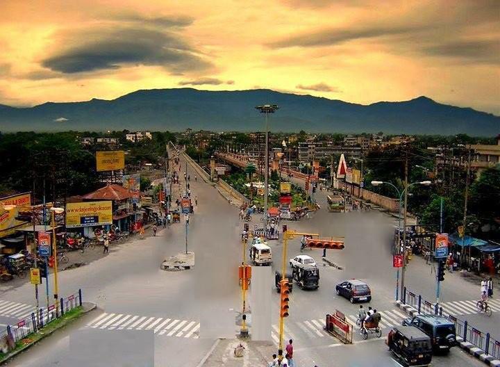


Why visit Siliguri
Townapedia lists 14 parks and trails, 215 places to eat, 61 places to stay and 3 attractions in and around town.
Highlights include Kanchenjunga Stadium and Savin Kingdom.
Weather in Siliguri
Forecast from MET Norway (CC BY 4.0). Full forecast
About Siliguri
Siliguri (, Bengali pronunciation: [ʃiliɡuɽi]; ), also known as Shiliguri, is a major tier-II city in West Bengal. It forms the Twin Cities with the neighbouring city of Jalpaiguri. The city spans areas of the Darjeeling and Jalpaiguri districts in the Indian state of West Bengal. Known as the "Gateway of Northeast India", It is located on the banks of the Mahananda in the foothills of the Himalayas.
From the Wikipedia article Siliguri (this version), under CC BY-SA 4.0.
Travel tips from other travellers: Siliguri on Wikivoyage (CC BY-SA 4.0).
Things to do3

Parks, trails and playgrounds14




2 more on the map.
Restaurants and cafes215

Mahabir Bhojanalaya
Restaurant · Chinese, Indian, Ice Cream, Noodles, Sandwich, Tea · 0.8 km
Hill Cart Road
Mo-Su 07:30-22:00

Rajasthani Zaika
Cafe · Tea, Onion Kachori, Samosa, Coffee · 1.6 km
Ward 13 Bhagat Singh Sarani, Siliguri
Mo-Su 08:00-20:00
Cafe King
Restaurant · Chinese, Coffee Shop, Indian, Regional · 1.8 km
Mo-Su 08:00-00:00
Maa Hotel
Restaurant · Indian · 1.3 km
Lunch & Dinner
Bengal International
Restaurant · 0.6 km
Hill Cart Road, Siliguri
Cafe Bongtastic
Cafe · 0.9 km
Sayed Mustafa Ali Road, Hakimpara, Siliguri
Dasabhuja
Restaurant · Indian, Noodle, Fish, Chicken, Wings, Fish And Chips · 1.0 km
203 more on the map.
Where to stay61

Atathi Niwas
Motel and hotel · 2.4 km
Old Matigara Rd.
24/7
Hotel Amaravati
Motel and hotel · 1.2 km
Station Feeder Road, Siliguri
Hotel Bluesky Residency
Motel and hotel
Open in Google Maps · 03532430473; +91 99334 46650; +91 94750 89747
49 more on the map.
Churches and places of worship17
Shopping123
Gas and EV charging12
Schools, colleges and libraries22
Healthcare116
Neotia Getwel Multispecialty Hospital
Hospital · 3.9 km
Neotia Getwel Multispecialty Hospital Uttorayon, Behind City Centre, Matigara, Siliguri
Map of Siliguri
250 places. The map loads OpenStreetMap tiles when you open it.
Getting there and nearby towns
Bagdogra Airport (IXB) is the nearest airport with scheduled flights listed in OpenStreetMap, 10 km away.
- Bagdogra 12 km west, about 12 min by car
- Naksalbāri 21 km west, about 21 min by car
- Kurseong 24 km northwest, about 24 min by car
- Odlābāri 24 km northeast, about 24 min by car
- Mirik 31 km northwest, about 31 min by car
- Jalpāiguri 37 km southeast, about 37 min by car
- Dārjiling 39 km northwest, about 39 min by car
- Kālimpong 41 km northeast, about 41 min by car
- Maināguri 42 km southeast, about 42 min by car
- Thākurganj 43 km southwest, about 43 min by car
Drive times are estimates from straight-line distance, not routes.
Local news
Headlines from INDB.
Reviews, tips and questions
Loading what members have shared...
Sources and licences
- GeoNames (CC BY 4.0): population, coordinates, regions and time zone
- OpenStreetMap contributors (ODbL 1.0): places, airports, map data
- Wikidata (CC0 1.0): elevation, founding date, time zone, website
- Wikimedia Commons (see each image): photos
- Wikipedia (CC BY-SA 4.0): overview and history text
Photo credits
- Siliguri view, Sayantani, CC BY-SA 3.0
- Siliguri college Administrative Block, JoydipBarmankd, CC BY-SA 4.0
- Sports 4, Sourik8, CC BY-SA 4.0
Page built November 2, 2026. Spotted a mistake? Tell us or suggest a place.