


Weather in Siuri
Forecast from MET Norway (CC BY 4.0). Full forecast
About Siuri
Suri () (also spelt as Siuri) is a city and a municipality in the Indian state of West Bengal. It is the headquarters of the Birbhum district. This city was established during the British Period (1876), makes it one of the oldest municipalities in the State.Suri is a rapidly growing municipality, makes it one the best suitable choices for living among the district people.Suri is the second largest and 2nd most Populous city in Birbhum District after Bolpur.Suri is the most densely populated city in the district. Located at the banks of Mayurakshi River and exactly in the centre of the district make this city an Political, cultural, commercial hub.
From the Wikipedia article Suri, Birbhum (this version), under CC BY-SA 4.0.
Travel tips from other travellers: Siuri on Wikivoyage (CC BY-SA 4.0).
Gas and EV charging1

Healthcare9


History
Prior to the advent of the British in India and their acquisition of the territory of Bengal, Suri was but merely a small village. Yet, the British colonists preferred to choose Suri as the district headquarters of Birbhum, probably owing to convenience of transport and communication. Suri was well-connected to many places via road, however, it is not possible to tell about the conditions of those roads clearly. These roads can be traced in James Rennel's map of the 'Jungleterry District'(1779).
After the defeat of Siraj ud-Daulah, the Nawab of Bengal, the British placed many puppet-kings in his place. When Mir Quasim was the Nawab, he ordered all the zamindars (landlords) to pay more revenue. At this, the ruler of Rajnagar, Asad Jama Khan disagreed. In December 1760, the army of the Nawab and the British marched together to attack Birbhum. Asad Jama Khan also got prepared with a cavalry of about 5,000 soldiers, and an infantry of nearly 20,000. In the battle, Asad Jama Khan was defeated and his zamindari was snatched. He took shelter amidst the very dense woods of Chotanagpur. There he had a clandestine meeting with a Maratha army general, Shivabhatta, and Shivabhatta joined him with a cavalry of two to three thousand soldiers as well as a large infantry. Another battle was fought near Kariddhya in 1763 in which he was defeated again. Thus, the British got the control of Suri.
From the History section of Suri, Birbhum on Wikipedia, under CC BY-SA 4.0.
Map of Siuri
10 places. The map loads OpenStreetMap tiles when you open it.
Getting there and nearby towns
Kazi Nazrul Islam Airport (RDP) is the nearest airport with scheduled flights listed in OpenStreetMap, 43 km away.
- Sainthia 16 km east, about 16 min by car
- Bakreswar 16 km west, about 16 min by car
- Ahmadpur 18 km southeast, about 18 min by car
- Dubrājpur 20 km southwest, about 20 min by car
- Bolpur 32 km southeast, about 32 min by car
- Rampur Hat 40 km northeast, about 40 min by car
- Durgapur 49 km southwest, about 49 min by car
- Āsansol 61 km southwest, about 1 h by car
- Baharampur 77 km east, about 1 h 15 min by car
- Barddhamān 80 km southeast, about 1 h 15 min by car
Drive times are estimates from straight-line distance, not routes.
Local news
Headlines from INDB.
Reviews, tips and questions
Loading what members have shared...
Sources and licences
- GeoNames (CC BY 4.0): population, coordinates, regions and time zone
- OpenStreetMap contributors (ODbL 1.0): places, airports, map data
- Wikidata (CC0 1.0): elevation, founding date, time zone, website
- Wikimedia Commons (see each image): photos
- Wikipedia (CC BY-SA 4.0): overview and history text
Photo credits
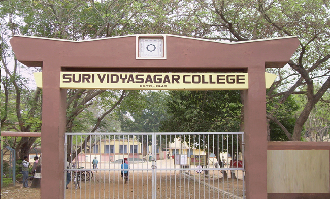
- Suri Vidyasagar College, Tyrannix, CC BY-SA 3.0
- Siuri Damodar Temple Left Vertical03 Panel04 01, Sumitsurai, CC BY-SA 4.0
- Siuri Damodar Temple Front Door Centre DoorTop Panel 01, Sumitsurai, CC BY-SA 4.0
- Siuri Damodar Temple Front OuterRight Pillar Base 01, Sumitsurai, CC BY-SA 4.0
- Siuri Damodar Temple Left Vertical03 Panel05 01, Sumitsurai, CC BY-SA 4.0
- Siuri Damodar Temple Front 01, Sumitsurai, CC BY-SA 4.0
- Siuri Damodar Temple TopArch 01, Sumitsurai, CC BY-SA 4.0
- Siuri Damodar Temple Right Side Panel 02, Sumitsurai, CC BY-SA 4.0
- Siuri Damodar Temple Front Door Centre DoorTop Panel 03, Sumitsurai, CC BY-SA 4.0
- Siuri Damodar Temple Front Door Right DoorTop 01, Sumitsurai, CC BY-SA 4.0
- Siuri Damodar Temple Front PillarTop02 01, Sumitsurai, CC BY-SA 4.0
- Siuri Damodar Temple TopArch 03, Sumitsurai, CC BY-SA 4.0
- Siuri Damodar Temple Top Right 02, Sumitsurai, CC BY-SA 4.0
- Siuri Damodar Temple Right Vertical Panel02 0809 01, Sumitsurai, CC BY-SA 4.0
- Siuri Damodar Temple Top Left, Sumitsurai, CC BY-SA 4.0
- Siuri Damodar Temple Front Door Left DoorTop 01, Sumitsurai, CC BY-SA 4.0
- Siuri Damodar Temple Left Vertical03 Panel03 01, Sumitsurai, CC BY-SA 4.0
- Siuri Damodar Temple Left Vertical03 Panel0708 01, Sumitsurai, CC BY-SA 4.0
- Siuri Damodar Temple Front 03, Sumitsurai, CC BY-SA 4.0
- Siuri Damodar Temple Top Right 01, Sumitsurai, CC BY-SA 4.0
- Siuri Damodar Temple Front TopArch 01, Sumitsurai, CC BY-SA 4.0
- Siuri Damodar Temple Right Side Panel 01, Sumitsurai, CC BY-SA 4.0
- Siuri Damodar Temple Left Vertical03 Panel0607 01, Sumitsurai, CC BY-SA 4.0
- Siuri Damodar Temple Front 02, Sumitsurai, CC BY-SA 4.0
- Siuri Damodar Temple TopArch 02, Sumitsurai, CC BY-SA 4.0
- Siuri Damodar Temple Front OuterRight Pillar Base 02, Sumitsurai, CC BY-SA 4.0
- Siuri Damodar Temple Front Door Centre DoorTop Panel 02, Sumitsurai, CC BY-SA 4.0
- Siuri Damodar Temple Front Pillar02 Left FigureRow01 01, Sumitsurai, CC BY-SA 4.0
- Vivekananda Granthagar 01, Tisha Mukherjee, CC BY-SA 4.0
- Vivekananda Granthagar 02, Tisha Mukherjee, CC BY-SA 4.0
- Radha-Damodar Temple, Suri, Birbhum, West Bengal, India, Samidh om Sadhu, CC BY-SA 4.0
- Damodar Temple 01, Tisha Mukherjee, CC BY-SA 4.0
- Damodar Temple 02, Tisha Mukherjee, CC BY-SA 4.0
- Suri Christian Cemetery 03, Tisha Mukherjee, CC BY-SA 4.0
- Suri Christian Cemetery 04, Tisha Mukherjee, CC BY-SA 4.0
- Suri Christian Cemetery 02, Tisha Mukherjee, CC BY-SA 4.0
- Suri Christian Cemetery 08, Tisha Mukherjee, CC BY-SA 4.0
- Suri Christian Cemetery 07, Tisha Mukherjee, CC BY-SA 4.0
- Suri Christian Cemetery 06, Tisha Mukherjee, CC BY-SA 4.0
- Suri Christian Cemetery 10, Tisha Mukherjee, CC BY-SA 4.0


Page built November 3, 2026. Spotted a mistake? Tell us or suggest a place.