


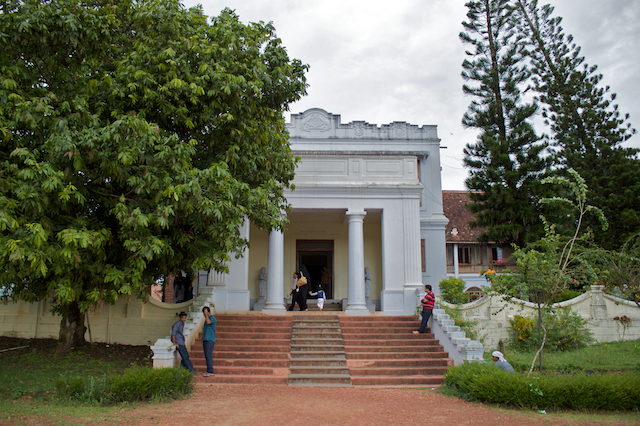


Why visit Thiruvankulam
Townapedia lists 3 museums and landmarks, 7 parks and trails, 46 places to eat, 14 places to stay and 5 attractions in and around town.
Highlights include Central Talkies, Hill Palace Complex and Hill Palace.
Weather in Thiruvankulam
Forecast from MET Norway (CC BY 4.0). Full forecast
Things to do5


Museums and landmarks3
Hill Palace
Museum · 0.7 km
Archeological museum, heritage museum in Kochi, India

Parks, trails and playgrounds7

Thanneerchal Park
Park · 1.5 km
Chithrappuzha-Ponjassery Rd, Tripunithura Refinery Road, Ernakulam
Mekkara Children's Park
Park · 1.9 km
Market Rd, Mekkara, Tripunithura, Ernakulam

Restaurants and cafes46


34 more on the map.
Where to stay14
Churches and places of worship67
Kandanad St. Marys Jacobite Syrian Cathedral
Church · Jacobite · 2.5 km
Kandankav Temple Road, Kandanad
Kannan Kulangara Shiva Temple
Place of worship · 2.1 km
Kannankulangara Mini Byepass Thripunithara, thripunithara
Sri Rama Temple
Place of worship · Gowda Saraswat Brahmin · 2.5 km
Sri Rama Temple Road, Tripunithura
St George Jacobite Syrian Cathedral
Church · Jacobite · 1.1 km
Seaport Airport Road, Kochi
Shopping22
Gas and EV charging6
Electric vehicle charging station
EV charging · 2.1 km
In central takies compound
Schools, colleges and libraries44
Government High School Thiruvankulam
School · 1.4 km
high school road, Kadungamangalam
Sree Narayana Dharma Paripalana Lower Primary School Irimpanam
School · 1.8 km
THRIPPUNITHURA, ERNAKULAM
Vocational Higher Secondary School, Irimpanam
School · 1.4 km
THRIPPUNITHURA, Ernakulam
Healthcare49
Janatha Medical Centre
Clinic and pharmacy · 2.0 km
Ammankovil Ettumanoor - Ernakulam Road, Tripunithara
Urban Primary Health Centre UPHC, Elamanthoppu,Thripunithura
Clinic and pharmacy · 1.7 km
Ayurveda Panchakarma Hospital
Clinic and pharmacy · 2.3 km
Layam Road, Tripunithura
Family Health Care
Clinic and pharmacy · 2.1 km
NH85, Old Bus Stand Road, Thrippunithura
Gospel Clinic And Diabetic Care Centre
Clinic and pharmacy · 1.9 km
Kannankulangara Mini Byepass Thripunithara, thripunithara
Primary Health Centre
Clinic and pharmacy · 1.1 km
Padam Road, Irumpanam, Thrippunithra
Map of Thiruvankulam
250 places. The map loads OpenStreetMap tiles when you open it.
Getting there and nearby towns
Cochin International Airport (COK) is the nearest airport with scheduled flights listed in OpenStreetMap, 23 km away.
- Kumbalam 8 km southwest, about 8 min by car
- Arukutti 9 km south, about 9 min by car
- Kochi 12 km west, about 12 min by car
- Aroor 11 km southwest, about 11 min by car
- Vypīn 13 km west, about 13 min by car
- Elūr 16 km northwest, about 16 min by car
- Kutiatodu 17 km south, about 17 min by car
- Piravam 17 km southeast, about 17 min by car
- Alwaye 18 km north, about 18 min by car
- Thaikkattussery 20 km south, about 20 min by car
Drive times are estimates from straight-line distance, not routes.
Local news
Headlines from INDB.
Reviews, tips and questions
Loading what members have shared...
Sources and licences
- GeoNames (CC BY 4.0): population, coordinates, regions and time zone
- OpenStreetMap contributors (ODbL 1.0): places, airports, map data
- Wikidata (CC0 1.0): elevation, founding date, time zone, website, landmarks and historic places
- Wikimedia Commons (see each image): photos
Photo credits
- KandanadChurch, Manoj R S, Public domain
- Hill palace front view, Captain, CC BY-SA 3.0
- RLV College of Fine Arts, Amolnaik3k, Public domain
- Chakkamkulangara Temple at evening with Banyan Tree IMG 6465, Cibu ( talk ), Public domain
- Hill Palace by GV-1, Gokulvarmank, CC BY 3.0
- Nadamel Marth Mariam Church, Jainpt, CC BY-SA 4.0
- Thripoonithura hill palace (back view ), Numi nusmi, CC BY-SA 4.0
- Hill palace horse cart room back of palace, Captain, CC BY-SA 3.0
- The Magnificent beauty of history of Kochi rulers, NobinJose6, CC BY-SA 4.0
- Cremation ground of Parikshith Thampuran 04, Vis M, CC BY-SA 4.0
- Cremation ground of Parikshith Thampuran 01, Vis M, CC BY-SA 4.0
- Cremation ground of Parikshith Thampuran 02, Vis M, CC BY-SA 4.0
- Cremation ground of Parikshith Thampuran 03, Vis M, CC BY-SA 4.0
- Weapon muesuem of hill palace, Numi nusmi, CC BY-SA 4.0
- Thripoonithura hill palace, Numi nusmi, CC BY-SA 4.0
- Hill Palace Museum Tripunithura DSC 1230, Ranjith Siji, CC BY-SA 4.0
- Hill Palace Museum Tripunithura DSC 1231, Ranjith Siji, CC BY-SA 4.0
- Hill Palace Museum Tripunithura DSC 1232, Ranjith Siji, CC BY-SA 4.0
- Hill Palace Museum Tripunithura DSC 1235, Ranjith Siji, CC BY-SA 4.0
- Hill Palace Museum Tripunithura DSC 1237, Ranjith Siji, CC BY-SA 4.0
- Hill Palace Museum Tripunithura DSC 1233, Ranjith Siji, CC BY-SA 4.0
- Hill Palace Museum Tripunithura DSC 1242, Ranjith Siji, CC BY-SA 4.0
- Hill Palace Museum Tripunithura DSC 1234, Ranjith Siji, CC BY-SA 4.0
- Hill Palace Museum Tripunithura DSC 1415, Ranjithsiji, CC BY-SA 4.0
- Hill Palace Museum Tripunithura DSC 1416, Ranjithsiji, CC BY-SA 4.0
- Hill Palace Museum Tripunithura DSC 1324, Ranjithsiji, CC BY-SA 4.0
- Hill Palace Museum Tripunithura DSC 1243 06, Ranjithsiji, CC BY-SA 4.0
- Hill Palace Museum Tripunithura DSC 1334, Ranjithsiji, CC BY-SA 4.0
- Hill Palace Museum Tripunithura DSC 1448, Ranjithsiji, CC BY-SA 4.0
- Hill Palace Museum Tripunithura DSC 1243 25, Ranjithsiji, CC BY-SA 4.0
- Hill Palace Museum Tripunithura DSC 1397, Ranjithsiji, CC BY-SA 4.0
- Hill Palace Museum Tripunithura DSC 1243 09, Ranjithsiji, CC BY-SA 4.0
- Hill Palace Museum Tripunithura DSC 1555, Ranjithsiji, CC BY-SA 4.0
- Hill Palace Museum Tripunithura DSC 1422, Ranjithsiji, CC BY-SA 4.0
- Hill Palace Museum Tripunithura DSC 1392, Ranjithsiji, CC BY-SA 4.0
- Hill Palace Museum Tripunithura DSC 1240 02, Ranjithsiji, CC BY-SA 4.0
- Hill Palace Museum Tripunithura DSC 1243 21, Ranjithsiji, CC BY-SA 4.0
- Hill Palace Museum Tripunithura DSC 1243 23, Ranjithsiji, CC BY-SA 4.0
- Hill Palace Museum Tripunithura DSC 1243 24, Ranjithsiji, CC BY-SA 4.0
- Hill Palace Museum Tripunithura DSC 1342, Ranjithsiji, CC BY-SA 4.0


Page built November 3, 2026. Spotted a mistake? Tell us or suggest a place.