
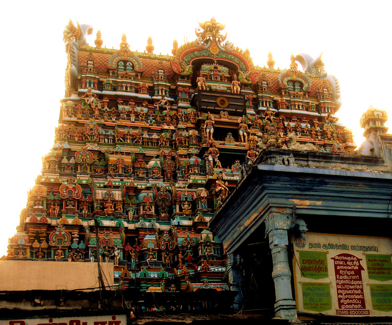


Why visit Tirunelveli
Townapedia lists 4 museums and landmarks, 5 parks and trails, 18 places to eat, 6 places to stay and 9 attractions in and around town.
Highlights include Adichanallur archaeological site and Porunai Museum.
Weather in Tirunelveli
Forecast from MET Norway (CC BY 4.0). Full forecast
About Tirunelveli
Tirunelveli (Tamil: [tiɾɯnelʋeːli] ), also known as Nellai, is a city and municipal corporation in the Indian state of Tamil Nadu. It is located on the southern part of the state, on the west bank of the Thamirabarani River. It is the administrative headquarters of the Tirunelveli District. As per the 2011 census, it had a population of 473,637 individuals, and was the seventh-largest city in the state by population.
From the Wikipedia article Tirunelveli (this version), under CC BY-SA 4.0.
Travel tips from other travellers: Tirunelveli on Wikivoyage (CC BY-SA 4.0).
Things to do9

Museums and landmarks4


Adichanallur archaeological site
Monument and historic site · 1.8 km
Archaeological site in Tamil Nadu


Parks, trails and playgrounds5


Restaurants and cafes18

Sri Madhuram's Hot Spot
Restaurant · Coffee Shop, Indian, Regional · 2.1 km
Swamy Nellaiapar High road, Tirunelveli

Hotel New Friends
Restaurant · Indian, Chinese · 0.7 km
Lalugapuram, Tirunelveli
Mo-Su 10:30-22:30

Shanthi Sweets and Bakery
Bakery · 2.2 km
415 Cheranmahadevi Road
Mo-Sa 08:30-22:30; Su 17:30-22:00
Arasan Bakery
Bakery · 2.9 km
Arasan Building Madurai Road, Tirunelveli Junction, Tirunelveli
Mo-Su 08:00-22:00
Hari Prasaath
Restaurant · 5.8 km
Varanasi - Kanniyakumari Road (Old NH7)
Mo-Su 06:30-23:00
6 more on the map.
History
Tirunelveli was part of the Pandian Empire, references to which are present in the Sangam literature, and inscriptions dating back to the 3rd century BCE. The region came under the rule of the Cholas in the 11th century CE. It remained under the control of the Cholas until the early 13th century CE, when the Pandyas re-established control over the region, and ruled with Madurai as the capital. During the 13th and 14th centuries, Tirunelveli was the secondary capital of Pandimandalam, the country ruled by the Pandyas.
The Nellaiappar temple was the royal shrine of the later Pandyas, and the city benefited from extensive irrigation facilities were developed based on the Thamirabarani River. The Vijayanagara Empire occupied the region in the 15th century CE. During the Vijayanagara rule, Brahmin and Vellalar chieftains held rights over community lands ('kani') in the Thamirabarani valley, while Maravar and Shanar migrants settled around the region. The Maravars populated the western foothills, the Kannadigas and Telugus settled on the eastern dry tracts of land. In the 16th century CE, the region was ruled by the Madurai Nayaks, and Tirunelveli served as the subsidiary capital of the Nayak territory. The city was rebuilt extensively during the reign of Viswanatha Nayak (1529–64), who also developed several temples in the region.
From the History section of Tirunelveli on Wikipedia, under CC BY-SA 4.0.
Where to stay6
Churches and places of worship68
Arulmigu Sivakamithayar Udanurai Kailasanathar Temple
Place of worship · Saivam · 10.9 km
Sri Gothaparameshwar Sri Sivagami Ambal Temple
Place of worship · Saivam · 4.1 km
Arulmigu Kanakasabapati Sundarambikai Sametha Sundareswarar Temple
Place of worship · 10.6 km
Sri Gnanambikai Sametha Sri Kalahastheeswarar Temple
Place of worship · 10.1 km
Kanthimathi Amman Sannithi
Place of worship · Saivam
East car street, Tirunelveli
Sathiram Pallivasal
Place of worship · Sunni · 2.2 km
Swamy Nellaiapar High road, Tirunelveli
St. Antonys Catholic Church
Church · Catholic · 2.4 km
Bharathar North Street, Tirunelveli
Swamy Nellaiappar Sannithi
Place of worship · Saivam
East car street, Tirunelveli Town, Tirunelveli
Arulmigu Athisaya Vinayagar Temple
Place of worship · 7.6 km
Maharajanagar, Tirunelveli
Shopping6
Annai Supermarket
Grocery · 2.3 km
419/1 Cheranmahadevi Road, Near Rottikadai Bus Stop, Pettai, Tirunelveli
Gas and EV charging25
Bharat Petroleum
Gas station · 10.5 km
Kanyakumari - Varanarasi Road, Ponnakudi, Tirunelveli
Schools, colleges and libraries43
Angelo Matriculation Hr. Sec. School
School · 6.7 km
Highground road, Palayamkottai, Tirunelveli
Healthcare206
Gandhiji Iyarkai Maruthuva Manai
Clinic and pharmacy · 2.5 km
Bharathar South Street
MedPlus
Clinic and pharmacy · 9.7 km
Doorr No.68B&C Tiruchendur - Palayamkottai - Ambasamudram - Tenkasi - Courtalam - Shencottai Road, Vijayaraghava Mudaliyar Chatiram, Tiruelveli
Map of Tirunelveli
250 places. The map loads OpenStreetMap tiles when you open it.
Getting there and nearby towns
Tuticorin Airport (TCR) is the nearest airport with scheduled flights listed in OpenStreetMap, 38 km away.
- Nāranammālpuram 7 km northeast, about 7 min by car
- Gopālasamudram 8 km southwest, about 8 min by car
- Sankarnagar 9 km northeast, about 9 min by car
- Mel Seval 10 km southwest, about 10 min by car
- Pattamadai 13 km southwest, about 13 min by car
- Cheranmahadevi 14 km southwest, about 14 min by car
- Mukkūdal 18 km west, about 18 min by car
- Vadakku Viravanallur 18 km west, about 18 min by car
- Gangaikondān 18 km northeast, about 18 min by car
- Mūlaikkaraippatti 22 km southeast, about 22 min by car
Drive times are estimates from straight-line distance, not routes.
Local news
Headlines from INDB.
Reviews, tips and questions
Loading what members have shared...
Sources and licences
- GeoNames (CC BY 4.0): population, coordinates, regions and time zone
- OpenStreetMap contributors (ODbL 1.0): places, airports, map data
- Wikidata (CC0 1.0): elevation, founding date, time zone, website, landmarks and historic places
- Wikimedia Commons (see each image): photos
- Wikipedia (CC BY-SA 4.0): overview and history text
Photo credits
- Nellaiappar2, Vashikaran Rajendrasingh, Public domain
- Tirunelveli Medical College Auditorium, Pon Malar, CC BY-SA 3.0
- Kunnathur Kotha parameswarar temple, Booradleyp1, CC BY-SA 4.0
- Kodaganallur Kailasanathar Temple, Booradleyp1, CC BY-SA 4.0
- Tirunelveli Medical College2, Kallidaimaniac ( talk ), Public domain
- Adichanallur Urn, Balurbala, CC BY-SA 4.0
- Manonmanium Sundarnar university, சத்திரத்தான், CC BY-SA 4.0

Page built November 2, 2026. Spotted a mistake? Tell us or suggest a place.