
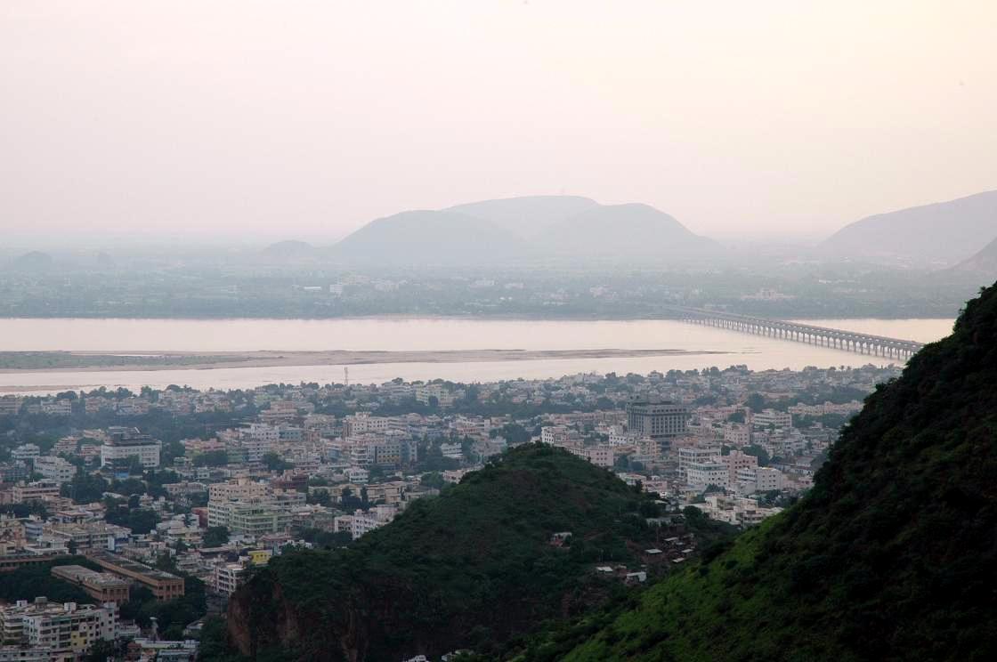


Why visit Vijayawada
Townapedia lists 2 museums and landmarks, 6 parks and trails, 180 places to eat, 28 places to stay and 10 attractions in and around town.
Highlights include School of Planning and Architecture, Vijayawada, Dr. N.T.R University of Health Sciences, Victoria Jubilee Museum and Statue of Social Justice.
Weather in Vijayawada
Forecast from MET Norway (CC BY 4.0). Full forecast
About Vijayawada
Vijayawada, also called as Bezawada, is the second largest city and a major commercial hub in the Indian state of Andhra Pradesh. The city forms an integral part of the Andhra Pradesh Capital Region and is situated on the banks of the Krishna River, flanked by the Eastern Ghats and the Indrakeeladri Hills.
From the Wikipedia article Vijayawada (this version), under CC BY-SA 4.0.
Travel tips from other travellers: Vijayawada on Wikivoyage (CC BY-SA 4.0).
Things to do10

School of Planning and Architecture, Vijayawada
School · 1.1 km
Architecture school in Vijayawada, India

Dr. N.T.R University of Health Sciences
School · 2.6 km
State public university in Krishna, Andhra Pradesh, India

Kanaka Durga Varadhi
Bridge · 3.3 km
Road bridge over Krishna river, India
Koneru Lakshmaiah Education Foundation
School · 7.7 km
Institution of higher education in Vijayawada, India
Siddhartha Academy of Higher Education
School · 5.5 km
Engineering college in Vijayawada, Andhra Pradesh

Museums and landmarks2

Victoria Jubilee Museum
Museum · 2.0 km
Indian Victorian-built museum of archaeology in Andhra Pradesh


Parks, trails and playgrounds6

Chaya Tennis Academy
Park · 1.4 km
Tu-Su 06:00-8:30 16:00-20:30 Mo off
Nelson Mandela park
Park · 1.0 km
Quite good for any atmosphere
LIC colony 4th lane, vijayawada

Restaurants and cafes180

TFL
Restaurant
36-11-7/A Shanti Nagar 1st Line, Jammi Chettu Center, Mughal Raj Puram, Vijayawada
10:00-23:00

PRISA Cafe
Cafe · Ice Cream, Italian, Chinese, Burger, Regional · 1.3 km
Best Place in Vijayawada to enjoy a couple of hours with Food in PRISA
D.No 59-11-7/1, Beside Bakers Inn VSN Mall opp. to Kushal’s Jewellery, Gayatri Nagar, Benz Circle, Vijayawada
Mo-Su 10:00-22:00
RR Durbar
Restaurant
40-7-9 mogalrajapuram road, Jammi Chettu St, Sidhartha Nagar, Labbipet, Vijayawada
11:00-23:00
Southern Spice
Restaurant
Guru Nanak Colony Road, State Bank Colony, Benz Circle, Vijayawada
11:00-22:00
Lassi Shop
Cafe · Pizza, Burger · 1.6 km
A café that serves thick shakes, mojitos, smoothies and fresh juice.
M.G Road
Lotus The Food City
Restaurant
13-801 Seethangara Other End Of Prakasam Barage, Tadepalli(Mandal), Vijayawada
11:00-23:30
Rasoie
Restaurant · 0.7 km
40-1-29 Mahatma Gandhi Rd, Sidhartha Nagar, Labbipet, Vijayawada
12:00-15:30, 19:00-22:30

Vault Brewery
Bar and pub · 1.3 km
Micro Brewery and Restaurant
Imperial VSN Mall Gayatri Nagar, Benz Circle, Vijayawada
Mo-Su 11:00-23:00
Cross Roads Restaurant
Restaurant
32-9-18/2, Siddhartha College Rd, near Madhu Chowk, Mogalrajapuram, Christurajupuram, Vijayawada, Andhra Pradesh 520010 AS Rama Rao Road, VIJAYAWADA


Furtune Murali Park
Restaurant · Regional · 0.7 km
FORTUNE MURALI RARK MG Road, Vijayawada
168 more on the map.
History
Bezawada (as Vijayawada was known then) was founded around 626 A.D. by Paricchedi Kings. Vijayawada history reveals that Bezawada (Vijayawada) was ruled by King Madhava Varma (one of the kings of Vishnukundina dynasty). Chinese Buddhist scholar Xuanzang stayed a few years in Bezawada (Vijayawada) in around 640 A.D. to copy and study the Abhidhamma Pitaka, the last of the three pitakas (Pali for baskets) constituting the Pali canon, the scriptures of Theravada Buddhism.
Mogalrajapuram hills have five rock-cut temples, built during the fourth–ninth centuries. Some of the caves can be attributed to Vishnukundina dynasty. Akkana Madanna Caves, at the foot of Indrakeeladri Hill, is a monument of national importance.
At the foot of Indrakeeladri hills is the temple of Malleswara. The temple has inscriptions dating back to ninth century AD to 16th century AD by various kings. There are ten pillars and a mutilated slab (recognised as monuments by Archaeological Survey of India) with inscriptions in the Telugu language. Of them, the inscriptions issued by Yudhamalla I and II of Eastern Chalukyas are important.
In the early 16th century, during the reign of Qutb Shahi dynasty (also known as Golconda Sultanate), diamond mines were found near Vijayawada on the banks of Krishna River.
From the History section of Vijayawada on Wikipedia, under CC BY-SA 4.0.
Where to stay28
Jade Suites Hotel
Motel and hotel · 1.2 km
40-9-45, Acharya Ranga Nagar, Benz Circle, Vijayawada, Andhra Pradesh 520010 MG Road, Vijayawada
Mango Hotels Vybrant
Motel and hotel · 0.8 km
Kalyanam Ramarao St, Revenue Colony Park, Sidhartha Nagar, Benz Circle, Vijayawada, Andhra Pradesh 520010 MG Road, Vijayawada
Sri Sai Leela ladies Hostel
Motel and hotel · 1.5 km
Kaleswara Rao Road, Suryaraopeta
Churches and places of worship19
Karis Pradhana mandhiram
Church · 1.3 km
61-3/4-2, Balaji Nagar, Krishna Lanka, Vijayawada, Andhra Pradesh 530013 NH16, Vijayawada
Sri Mutyalamma talli Temple
Place of worship · 0.9 km
GJ6Q+FFX, Unnamed Road, Moghalrajpuram, Suryaraopeta, Vijayawada, Andhra Pradesh 520002 BELLAPU SHOBANADRI STREET, VIJAYAWADA
Shopping35
Grand Modern Super Market
Grocery · 1.5 km
Sultan Plaza, 40-1-87 MG Rd, Patamatalanka, Benz Circle, Vijayawada
Amaravathi Organics
Grocery
Venkat Heights Apartment, behind, opposite Modern Academy, near Jammichettu Centre, Moghalrajpuram, Shanti Nagar, Labbipet, Vijayawada, Andhra Pradesh 520010 Jammi Chettu Street, Vijayawada
Richies
Shop · 1.1 km
40-1-129A, MG Rd, beside HDFC Bank, Chandra Mouli Puram, Sriram Nagar, Vijayawada, Andhra Pradesh 520010 MG Road, Vijayawada
Gas and EV charging8
Schools, colleges and libraries36
Healthcare254
Map of Vijayawada
250 places. The map loads OpenStreetMap tiles when you open it.
Getting there and nearby towns
Vijayawada Airport (VGA) is the nearest airport with scheduled flights listed in OpenStreetMap, 17 km away.
- Yanamalakuduru 3 km southeast, about 3 min by car
- Kānūru 5 km east, about 5 min by car
- Tādepalle 6 km southwest, about 6 min by car
- Tādigadapa 7 km southeast, about 7 min by car
- Kolanukonda 7 km southwest, about 7 min by car
- Poranki 7 km southeast, about 7 min by car
- Vaddeswaram 8 km southwest, about 8 min by car
- Mangalagiri 12 km southwest, about 12 min by car
- Prasadampadu 12 km north, about 12 min by car
- Amaravati 14 km west, about 14 min by car
Drive times are estimates from straight-line distance, not routes.
Local news
Headlines from INDB.
Reviews, tips and questions
Loading what members have shared...
Sources and licences
- GeoNames (CC BY 4.0): population, coordinates, regions and time zone
- OpenStreetMap contributors (ODbL 1.0): places, airports, map data
- Wikidata (CC0 1.0): elevation, founding date, time zone, website, landmarks and historic places
- Wikimedia Commons (see each image): photos
- Wikipedia (CC BY-SA 4.0): overview and history text
Photo credits
- Vijayawada from Gandhi Hill, en:user:Man praveen, Public domain
- An entrance of 36th Vijayawada Book Festival, Saiphani02, CC BY-SA 4.0
- Floor plan of Trimurti rock-cut temple, Mogalrajapuram Vijayawada Andhra Pradesh, Ms Sarah Welch, CC0
- Swecha AP Vijayawada Floods banner, Saiphani02, CC BY 4.0
- Donated clothes for Vijayawada flood victims, Hemchand, Swecha AP, CC BY 4.0
- NTR University of Health Sciences, Cephas 405 ( talk ), CC BY-SA 3.0
- Bapu museum 18, Koushik, CC BY-SA 4.0
- Andhra layola college, vijayawada... inside (30), Bhaskaranaidu, CC BY-SA 4.0
- Statue of Social Justice, At night, Mr Nerd 96, CC BY-SA 4.0
- St.Pauls Cathedral, Vijayawada, vijayawadadiocese.org, CC BY-SA 4.0
- The Statue of Social Justice at Vijayawada, Sindhu Haridas, CC0
- OpenStreetMap Cake for 20th anniversary party at Swecha AP, Saiphani02, CC BY 4.0
- OSM 20th anniversary cake and cracker, Saiphani02, CC BY 4.0
- Discussion about OpenStreetMap at Swecha AP, Saiphani02, CC BY 4.0
- Discussing maps with kids at OSM mapping party, Saiphani02, CC BY 4.0
- Mapping activity for kids at Swecha AP Office, Saiphani02, CC BY 4.0
- Kids working on paper maps at an OSM mapping party, Saiphani02, CC BY 4.0
- Volunteers loading boxes of clothes onto truck, Saiphani02, CC BY 4.0
- Steps at Mogalrajpuram Caves, Saiphani02, CC BY-SA 4.0
- Ravi Neuro Center, Yaswanth Mungara, CC0
- Public speech during a community gathering with Hanuman statue in the background, India, Unknown author, CC0
- BZA WMIN Strategy Meet, Group 1, Krishna Chaitanya Velaga, CC BY-SA 4.0
- BZA WMIN Strategy Meet, Saifullah from Group 1 explaning ideas, Krishna Chaitanya Velaga, CC BY-SA 4.0
- BZA WMIN Strategy Meet, participants overview, Krishna Chaitanya Velaga, CC BY-SA 4.0
- BZA WMIN Strategy Meet, Group 4 durin group discussions, Krishna Chaitanya Velaga, CC BY-SA 4.0
- BZA WMIN Strategy Meet, Anant from Group 1 explaning ideas, Krishna Chaitanya Velaga, CC BY-SA 4.0
- BZA WMIN Strategy Meet, Nikhil from IIIT DM, Krishna Chaitanya Velaga, CC BY-SA 4.0
- BZA WMIN Strategy Meet, Krishna Alapati from MAD, Krishna Chaitanya Velaga, CC BY-SA 4.0
- BZA WMIN Strategy Meet, Sripati during discussion round, Krishna Chaitanya Velaga, CC BY-SA 4.0
- BZA WMIN Strategy Meet, Participants introcude themselves, Krishna Chaitanya Velaga, CC BY-SA 4.0
- BZA WMIN Strategy Meet, Group 2 during discussion, Krishna Chaitanya Velaga, CC BY-SA 4.0
- BZA WMIN Strategy Meet, Rohith from VVIT, Krishna Chaitanya Velaga, CC BY-SA 4.0
- BZA WMIN Strategy Meet, IdeaPads given to participants, Krishna Chaitanya Velaga, CC BY-SA 4.0
- BZA WMIN Strategy Meet, Akhil from Group 2 explaning ideas, Krishna Chaitanya Velaga, CC BY-SA 4.0
- BZA WMIN Strategy Meet, Anant from D98 of TMI, Krishna Chaitanya Velaga, CC BY-SA 4.0
- BZA WMIN Strategy Meet, Group 1 during discussions, Krishna Chaitanya Velaga, CC BY-SA 4.0
- BZA WMIN Strategy Meet, representatives from Toastmasters, Krishna Chaitanya Velaga, CC BY-SA 4.0
- BZA WMIN Strategy Meet, Manasa from Group 2 explaning ideas, Krishna Chaitanya Velaga, CC BY-SA 4.0
- BZA WMIN Strategy Meet, Ideas collected, Krishna Chaitanya Velaga, CC BY-SA 4.0
- BZA WMIN Strategy Meet, Nikhil from Group 4 explaning ideas, Krishna Chaitanya Velaga, CC BY-SA 4.0


Page built November 2, 2026. Spotted a mistake? Tell us or suggest a place.