
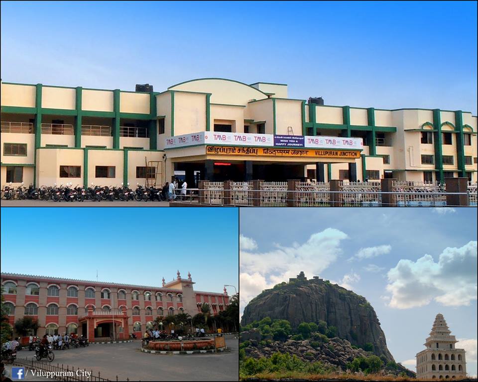


Villupuram, India
Villupuram is a town of 97,380 people in Tamil Nadu, India, founded in 1919.
Why visit Villupuram
Townapedia lists 1 museum or landmark, 4 parks and trails, 21 places to eat, 10 places to stay and 5 attractions in and around town.
Highlights include Mani Arasi Thirumana Mandabam.
Weather in Villupuram
Forecast from MET Norway (CC BY 4.0). Full forecast
About Villupuram
Viluppuram, Villupuram, or Vizhuppuram (Tamil: [ʋiɻɯppɯɾam] ) is a city and the administrative headquarters of Viluppuram district of Tamil Nadu.
From the Wikipedia article Viluppuram (this version), under CC BY-SA 4.0.
Travel tips from other travellers: Villupuram on Wikivoyage (CC BY-SA 4.0).
Things to do5

Mani Arasi Thirumana Mandabam
Scenic view · 3.2 km
201, East Pondy Road, Villupuram
24/7


Museums and landmarks1

Parks, trails and playgrounds4


Restaurants and cafes21



9 more on the map.
History
In 1677, [Shri Chhatrapati Shivaji Maharah] took Gingee area with the assistance of Golkonda forces. Later in 18th century, both the English and French acquired settlements in South Arcot. During the Anglo-French rivalry, the entire district was turned into a war land. After some time, the entire area came under the control of East India Company. It remained under British authority till 1947 when India became independent.
After independence, the district as we know it today, was part of the larger South Arcot District headquartered at Cuddalore. On 30 September 1993, Villupuram became the headquarters of the newly created Vizhuppuram District as a result of the division of the South Arcot District.
From the History section of Viluppuram on Wikipedia, under CC BY-SA 4.0.
Where to stay10
Churches and places of worship33
Hindu temple
Place of worship · Hindu · 1.9 km
Thirukurppu thondar nagar, keelperumpakkam
VARAHI AMMAN TEMPLE
Place of worship · 3.1 km
GINGEE ROOD, MUTHAL PATT, VILLUPURAM
Vinayagar Kovil
Place of worship · 3.0 km
Vinayagar Kovil street, Mel Muthampalayam
Arulmigu Sri Janakavalli Sameda Vaikundavasa Perumal Thirukoyil
Place of worship · 0.8 km
Shopping11
Gas and EV charging7
Schools, colleges and libraries35
District Central Library, Villupuram
Library · 1.7 km
Integrated Government offices Building, Villupuram, Villupuram
Saraswathi Matriculation Higher Secondary School
School · 1.0 km
Thiru-Vi-Ka Street, Villupuram
Arignar Anna Government Arts College - Ground
School · 2.1 km
SVS Avenue, Villupuram
C.S.I. St. James Matriculation School
School · 1.1 km
297 Villupuram - Puducherry Saalai
SARADA VIDYALAYA SCHOOL in Villupuram
School · 1.2 km
Virattikuppam Road, Virattikuppam Rd
Healthcare63
Map of Villupuram
190 places. The map loads OpenStreetMap tiles when you open it.
Getting there and nearby towns
Puducherry Airport (PNY) is the nearest airport with scheduled flights listed in OpenStreetMap, 35 km away.
- Sālamedu 3 km south, about 3 min by car
- Valavanur 10 km east, about 10 min by car
- Vikravāndi 12 km northeast, about 12 min by car
- Tiruvennanallūr 16 km southwest, about 16 min by car
- Lakshmīnārāyanapuram 18 km southeast, about 18 min by car
- Panruti 19 km south, about 19 min by car
- Cuddalore 36 km southeast, about 36 min by car
- Puducherry 37 km east, about 37 min by car
- Neyveli 37 km south, about 37 min by car
- Tiruvannamalai 56 km northwest, about 56 min by car
Drive times are estimates from straight-line distance, not routes.
Local news
Headlines from INDB.
Reviews, tips and questions
Loading what members have shared...
Sources and licences
- GeoNames (CC BY 4.0): population, coordinates, regions and time zone
- OpenStreetMap contributors (ODbL 1.0): places, airports, map data
- Wikidata (CC0 1.0): elevation, founding date, time zone, website
- Wikimedia Commons (see each image): photos
- Wikipedia (CC BY-SA 4.0): overview and history text
Photo credits
- Glory Of Viluppuram 2, Manivanswiki, CC BY-SA 3.0
- Keezperum Pakkam, Villupuram, Tamil Nadu 605602, India - panoramio, raguleo, CC BY 3.0
- Pallavan Superfast entering Villupuram Junction, Theharryy, CC BY-SA 4.0
- Villupuram Bus Stand, Gowtham Sampath, CC BY-SA 4.0
- Villupuram Bus Stand 2, Gowtham Sampath, CC BY-SA 4.0
- Viluppuram (49883), Manukrishnan80, CC BY-SA 3.0
- Viluppuram (35512), Manukrishnan80, CC BY-SA 3.0
- Viluppuram (82395), Manukrishnan80, CC BY-SA 3.0
- Viluppuram (64802), Manukrishnan80, CC BY-SA 3.0
- Viluppuram (15820), Manukrishnan80, CC BY-SA 3.0
- Viluppuram (97201), Manukrishnan80, CC BY-SA 3.0
- Viluppuram (65655), Manukrishnan80, CC BY-SA 3.0
- Viluppuram, Manukrishnan80, CC BY-SA 3.0
- Vilupuram Junction Railway station, Manukrishnan80, CC BY-SA 3.0
- Viluppuram Railway station, Manukrishnan80, CC BY-SA 3.0
- Viluppuram Railway station (66045), Manukrishnan80, CC BY-SA 3.0
- Viluppuram Railway station (34745), Manukrishnan80, CC BY-SA 3.0
- Viluppuram Railway station (31982), Manukrishnan80, CC BY-SA 3.0
- Viluppuram Railway station (91815), Manukrishnan80, CC BY-SA 3.0
- Vilupuram Junction Railway station (24826), Manukrishnan80, CC BY-SA 3.0
- 22403 Puducherry New Delhi Superfast train, Dr. Chinchu C., CC BY 4.0
- Viluppuram Junction railway station, Manukrishnan80, CC BY-SA 3.0
- Dog on Railway Station Platform, Dr. Chinchu C., CC BY 4.0
- Periyar Studies, Dhinakar01, CC BY-SA 4.0
- TamilNadu2011 1901, Indu, GFDL 1.2


Page built November 3, 2026. Spotted a mistake? Tell us or suggest a place.