


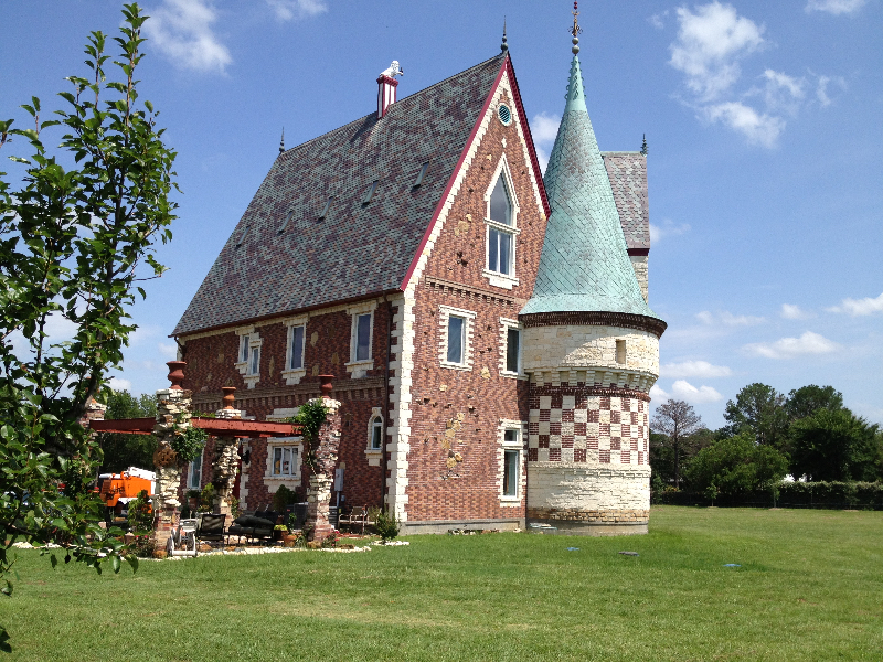


Joshua, Texas
Joshua is a city of 8,550 people in Johnson County, Texas, founded in 1881.
Why visit Joshua
Townapedia lists 2 museums and landmarks, 4 parks and trails, 24 places to eat and 2 attractions in and around town.
Highlights include Caddo Peak and Willow Creek Park.
August is the warmest month, with average highs of 95°F; January lows average 34°F.
Weather in Joshua
Forecast from the National Weather Service. Full forecast
About Joshua
Joshua is a city in Johnson County, Texas, United States. The population was 7,891 at the 2020 census.
From the Wikipedia article Joshua, Texas (this version), under CC BY-SA 4.0.
Things to do2

Museums and landmarks2

Parks, trails and playgrounds4


Mountain Valley Country Club (Disused)
Golf course · 2.2 mi
Old golf course. Non-usable due to neglect. Added because it is still there.

Restaurants and cafes24



The Brickhouse Grill
Diner · American
107 North Main Street, Joshua
12 more on the map.
History
Joshua is in the Cross Timbers region of Texas, on land patented by W. W. Byers in 1867. The section was sold in 1874 to John Powell. Caddo Grove, 2 miles (3 km) east of Joshua, was the first community in the area. It had its own post office and was a thriving town until the Gulf, Colorado and Santa Fe Railway was completed from Cleburne to Fort Worth in 1881. The railroad missed Caddo Grove, and a station was built on the tracks at the site of future Joshua. The station was originally called "Caddo Peak", but the name was rejected by the post office because of another community with that name. The name "Joshua" was chosen, purportedly by Dr. D. B. McMillan, after the biblical Joshua. W. L. West was the first postmaster when the community received a post office in 1882. In 1883, Caddo Grove's post office was withdrawn.
From the History section of Joshua, Texas on Wikipedia, under CC BY-SA 4.0.
Churches and places of worship5
Shopping3
Gas and EV charging6
Schools, colleges and libraries34
Healthcare4
Best Value Mountain Valley Pharmacy
Clinic and pharmacy · 1.6 mi
3521 Southwest Wilshire Boulevard, Joshua
Brookshire's Pharmacy
Clinic and pharmacy · 0.8 mi
1001 Joshua Station Boulevard, Joshua
Map of Joshua
84 places. The map loads OpenStreetMap tiles when you open it.
Climate by month
Monthly table
| Month | High | Low | Rain | Snow |
|---|---|---|---|---|
| Jan | 57°F | 34°F | 2.3 in | 0.0 in |
| Feb | 61°F | 37°F | 2.6 in | 0.0 in |
| Mar | 68°F | 44°F | 3.6 in | 0.0 in |
| Apr | 76°F | 52°F | 3.0 in | 0.0 in |
| May | 83°F | 61°F | 4.2 in | 0.0 in |
| Jun | 91°F | 69°F | 3.5 in | 0.0 in |
| Jul | 95°F | 72°F | 2.2 in | 0.0 in |
| Aug | 95°F | 72°F | 2.3 in | 0.0 in |
| Sep | 88°F | 65°F | 3.1 in | 0.0 in |
| Oct | 78°F | 54°F | 4.4 in | 0.0 in |
| Nov | 67°F | 44°F | 2.7 in | 0.1 in |
| Dec | 58°F | 35°F | 2.6 in | 0.1 in |
U.S. Climate Normals 1991-2020 for Burleson (4 mi away), NOAA NCEI.
People and cost of living
American Community Survey 5-year estimates, 2020-2024, U.S. Census Bureau. Estimates have margins of error, larger for small towns.
Disaster history
Johnson County has had 13 federal disaster declarations since 2000, most often for fires.
- 2021-02-19: Severe Winter Storms (Severe Ice Storm)
- 2021-02-14: Severe Winter Storm (Severe Ice Storm)
- 2020-03-25: Covid-19 Pandemic (Biological)
- 2020-03-13: Covid-19 (Biological)
- 2015-05-29: Severe Storms, Tornadoes, Straight-Line Winds And Flooding (Severe Storm)
- 2008-03-14: Wildfires (Fire)
OpenFEMA disaster declarations summaries.
Getting there and nearby towns
Naval Air Station Joint Reserve Base Fort Worth (Carswell Field) (FWH) is the nearest airport with scheduled flights listed in OpenStreetMap, 21 miles away.
- Burleson 5 mi northeast, about 8 min by car
- Cleburne 7 mi south, about 12 min by car
- Crowley 8 mi north, about 13 min by car
- Godley 9 mi west, about 14 min by car
- Alvarado 11 mi east, about 17 min by car
- Rendon 12 mi northeast, about 19 min by car
- Everman 13 mi northeast, about 21 min by car
- The Homesteads 13 mi east, about 20 min by car
- Edgecliff Village 14 mi north, about 22 min by car
- Benbrook 16 mi north, about 25 min by car
Drive times are estimates from straight-line distance, not routes.
Local news
Headlines from INDB, the NEMICO news database.
Reviews, tips and questions
Loading what members have shared...
Sources and licences
- NCES EDGE (Public domain): public schools
- NOAA NCEI U.S. Climate Normals 1991-2020 (Public domain): climate by month
- OpenFEMA (Public domain): disaster declarations
- OpenStreetMap contributors (ODbL 1.0): places, airports, map data
- U.S. Census Bureau (Public domain): population, income, housing, education, commute
- Wikidata (CC0 1.0): elevation, founding date, time zone, website
- Wikimedia Commons (see each image): photos
- Wikipedia (CC BY-SA 4.0): overview and history text
Photo credits
- Medardo Arias Leon, Eduardo.garnica, CC BY-SA 3.0
- Château Woda Nymphée1, RodneyLordHarrington, CC BY-SA 4.0
- Circa 1950's Television Remote Control made by Motorola, Cadejacksoncampbell, CC BY-SA 4.0
Page built October 30, 2026. Spotted a mistake? Tell us or suggest a place.