


Why visit Kapolei
Townapedia lists 8 museums and landmarks, 16 parks and trails, 48 places to eat, 3 places to stay and 8 attractions in and around town.
Highlights include Barbers Point Light, Consolidated Theatres, Naval Air Museum Barbers Point and Ko Olina Beach Park.
August is the warmest month, with average highs of 89°F; January lows average 65°F.
Weather in Kapolei
Forecast from the National Weather Service. Full forecast
About Kapolei
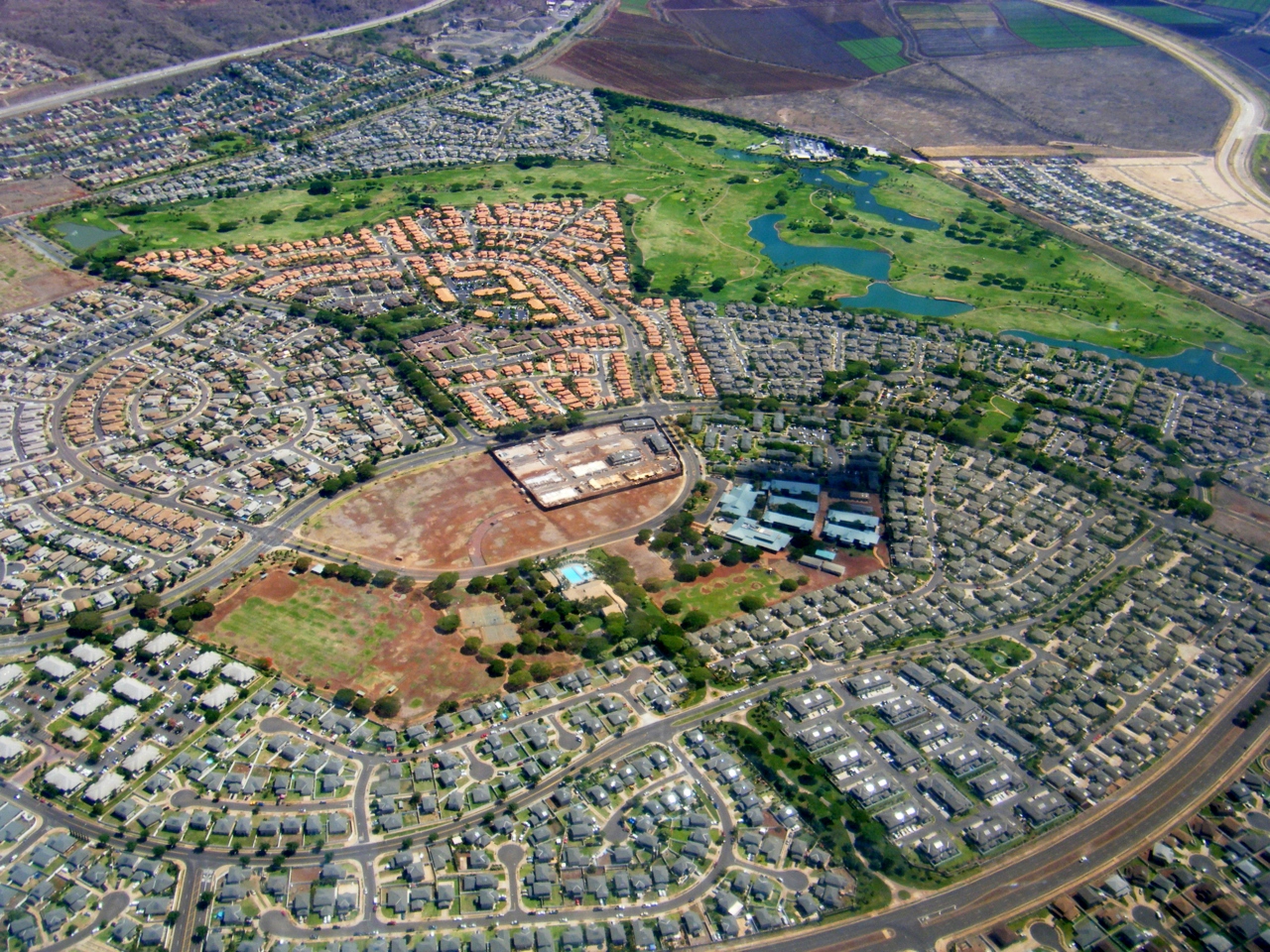
Kapolei (Hawaiian pronunciation: [kəpoˈlej]) is a planned community in the City and County of Honolulu, Hawaii, United States, on the island of Oahu. In 1977, the government designated it as the "second city" of Oʻahu, in relation to Honolulu. For statistical purposes, the United States Census Bureau has defined Kapolei as a census-designated place (CDP) within the consolidated city-county of Honolulu. As of the 2020 census, Kapolei had a population of 21,411.
From the Wikipedia article Kapolei, Hawaii (this version), under CC BY-SA 4.0.
Things to do8

Barbers Point Light
Lighthouse · 3.9 mi
Lighthouse in Hawaii, United States



University of Hawaiʻi–West Oʻahu
School · 1.3 mi
University in Hawaiʻi

Museums and landmarks8

Naval Air Museum Barbers Point
Museum · 1.8 mi
Military museum in Hawaii

Parks, trails and playgrounds16


Archery Center
Sports field and stadium · 0.5 mi
Decommissioned World War 2 coastal artillery battery that is now an archery range.

4 more on the map.
Restaurants and cafes48

The Cheesecake Factory
Diner · American · 1.2 mi
91 Ka Makana Alii Main Driveway, Kapolei
Mo-Fr 11:30-23:00; Sa-Su 10:00-23:00

Local Joe West
Cafe · Coffee, Coffee Shop · 1.8 mi
91-3598 Nana Hope Street, Ewa Beach
Mo,Fr 06:00-14:00; Tu-Th 06:30-14:00; Sa-Su 07:30-16:00
Teapresso Bar
Cafe · Bubble Tea · 1.0 mi
91-5431 Kapolei Parkway, Kapolei
Mo-Su 08:00-21:00

36 more on the map.
History
In 1955 the Kapolei master plan was drafted and revised 3 different times beginning in 1974. In 1977 the new General Provision Plan adopted the Oʻahu General Plan which dubbed Kapolei "second urban center" (SUC) on the island of Oʻahu. In 1986 the ʻEwa Master Plan was revised to include the SUC and the initial residential construction in the Kapolei area began in the late 1980s with commercial developments springing up shortly thereafter. Nearly two decades later, in 2006 the Kapolei area had more than 800 companies, agencies, and organizations making up approximately 25,000 jobs. As of the 2010 census, the Kapolei CDP had a population of 15,186 people.
The original development objectives for the City of Kapolei were to include: an employment center, a new center for offices and businesses, a center for government offices, a city of people walking, biking, or bussing, the latest energy-efficient technologies such as water conservation and recycling, and the most efficient connectivity for commuting on Oʻahu. In essence a "smart city". The design plan for development ensures that the 7 themes of Kapolei remain the same throughout its construction. These include 1. Hawaiian Garden City 2. Healthy Living 3. Complete Community Services 4. Pedestrian-friendly 5. Past/Present/Future design architecture 6. Sustainability 7. Technology.
From the History section of Kapolei, Hawaii on Wikipedia, under CC BY-SA 4.0.
Where to stay3
Hampton Inn & Suites Oahu/Kapolei
Motel and hotel · 1.1 mi
91-5434 Kapolei Parkway, Kapolei
Embassy Suites by Hilton Oahu Kapolei
Motel and hotel · 0.8 mi
725 Manawai Street, Kapolei
Churches and places of worship3
St. Jude Catholic Church
Church · Catholic · 0.7 mi
92-455 Makakilo Drive, Makakilo
Shopping13
Gas and EV charging7
Schools, colleges and libraries36
Dreamhouse Ewa Beach
School · 1.4 mi
91-1245 Franklin D Roosevelt Ave #A, Kapolei
Healthcare4
Straub Benioff Medical Center - Kapolei Clinic & Urgent Care
Clinic and pharmacy · 1.0 mi
91-5431 Kapolei Parkway
Map of Kapolei
146 places. The map loads OpenStreetMap tiles when you open it.
Climate by month
Monthly table
| Month | High | Low | Rain |
|---|---|---|---|
| Jan | 81°F | 65°F | 1.4 in |
| Feb | 81°F | 65°F | 1.8 in |
| Mar | 82°F | 66°F | 1.9 in |
| Apr | 84°F | 68°F | 0.6 in |
| May | 85°F | 69°F | 1.0 in |
| Jun | 87°F | 71°F | 0.3 in |
| Jul | 88°F | 72°F | 0.3 in |
| Aug | 89°F | 73°F | 0.6 in |
| Sep | 89°F | 72°F | 0.7 in |
| Oct | 87°F | 72°F | 1.3 in |
| Nov | 84°F | 69°F | 1.8 in |
| Dec | 82°F | 67°F | 2.3 in |
U.S. Climate Normals 1991-2020 for Ewa Kalaeloa Ap 91178 (2 mi away), NOAA NCEI.
People and cost of living
American Community Survey 5-year estimates, 2020-2024, U.S. Census Bureau. Estimates have margins of error, larger for small towns.
Disaster history
Honolulu County has had 19 federal disaster declarations since 2000, most often for hurricanes.
- 2026-10-07: Hurricane Lala (Hurricane)
- 2026-09-25: Tropical Storm Nolo (Tropical Storm)
- 2026-04-07: Severe Storms, Flooding, Landslides, And Mudslides (Flood)
- 2025-08-19: Kunia Road Fire (Fire)
- 2022-02-15: Severe Storms, Flooding, And Landslides (Severe Storm)
- 2020-07-25: Hurricane Douglas (Hurricane)
OpenFEMA disaster declarations summaries.
Getting there and nearby towns
Kalaeloa Airport (JRF) is the nearest airport with scheduled flights listed in OpenStreetMap, 2 miles away.
- Makakilo 2 mi northwest, about 3 min by car
- Ewa Villages 2 mi east, about 3 min by car
- Kalaeloa 2 mi south, about 3 min by car
- East Kapolei 2 mi northeast, about 4 min by car
- Ewa Gentry 3 mi east, about 4 min by car
- Ocean Pointe 3 mi southeast, about 5 min by car
- West Loch Estate 3 mi northeast, about 5 min by car
- Ko Olina 3 mi west, about 5 min by car
- Ewa Beach 4 mi southeast, about 7 min by car
- Waipahu 5 mi northeast, about 8 min by car
Drive times are estimates from straight-line distance, not routes.
Local news
Headlines from INDB, the NEMICO news database.
Reviews, tips and questions
Loading what members have shared...
Sources and licences
- NCES EDGE (Public domain): public schools
- NOAA NCEI U.S. Climate Normals 1991-2020 (Public domain): climate by month
- OpenFEMA (Public domain): disaster declarations
- OpenStreetMap contributors (ODbL 1.0): places, airports, map data
- U.S. Census Bureau (Public domain): population, income, housing, education, commute
- Wikidata (CC0 1.0): elevation, founding date, time zone, website, landmarks and historic places
- Wikimedia Commons (see each image): photos
- Wikipedia (CC BY-SA 4.0): overview and history text
Photo credits
- Kapolei Oahu Aerial, Travis.Thurston, CC BY-SA 3.0
- Kapolei 02, Farragutful, CC BY-SA 4.0
- St. Jude Catholic Church - Kapolei, Hawaii, Farragutful, CC BY-SA 4.0
- Oahu, Kapolei, United States (Unsplash), Teo Duldulao teowithacamera, CC0
- Barber's Point Lighthouse (6731785051), Pete Markham from Loretto, USA, CC BY-SA 2.0
- University of Hawai'i - West O'ahu(3), Mj-bird, CC BY-SA 4.0
- Funeral of Jonah Kūhiō Kalanianaʻole (PP-25-8-030), Unknown author Unknown author, Public domain
- 2014-May-8th Morning Kapole-Park- (15), Merrilydancingape, CC0
- 2014-May-8th Morning Kapole-Park- (17), Merrilydancingape, CC0
- 2014-May-8th Morning Kapole-Park- (9), Merrilydancingape, CC0
- 2014-May-8th Morning Kapole-Park- (14), Merrilydancingape, CC0
- 2014-May-8th Morning Kapole-Park- (16), Merrilydancingape, CC0
- 2014-May-8th Morning Kapole-Park- (12), Merrilydancingape, CC0
- 2014-May-8th Morning Kapole-Park- (8), Merrilydancingape, CC0
- 2014-May-8th Morning Kapole-Park- (4), Merrilydancingape, CC0
- 2014-May-8th Morning Kapole-Park- (10), Merrilydancingape, CC0
- 2014-May-8th Morning Kapole-Park- (13), Merrilydancingape, CC0
- 2014-May-8th Morning Kapole-Park- (3), Merrilydancingape, CC0
- 2014-May-8th Morning Kapole-Park- (7), Merrilydancingape, CC0
- 2014-May-8th Morning Kapole-Park- (6), Merrilydancingape, CC0
- 2014-May-8th Morning Kapole-Park- (5), Merrilydancingape, CC0
- 2014-May-8th Morning Kapole-Park- (11), Merrilydancingape, CC0
- 2014-May-8th Morning Kapole-Park- (18), Merrilydancingape, CC0
- 2014-May-8th Morning Kapole-Park- (2), Merrilydancingape, CC0
- 2014-May-8th Morning Kapole-Park- (1), Merrilydancingape, CC0
- Melon Bacterial wilt (Pathogen Erwinia tracheiphila) (34880985411), Scot Nelson, CC0
- Melon Bacterial wilt (Pathogen Erwinia tracheiphila) (35013337855), Scot Nelson, CC0
- Exit 2 Makakilo Dr Exit on H1, Queen Liliuokalani Fwy in Oahu, Hawaii, The Eloquent Peasant, CC0
- Kualaka‘i Skyline station, RickyCourtney, CC BY-SA 4.0
- University of Hawaii West-Oahu Campus Center and rainbow, University of Hawaii-West Oahu, CC BY-SA 4.0
- Aerial view of University of Hawaii - West Oahu, Derrick Coetzee ( User:Dcoetzee ), CC0
- Leeward Oahu From the Train (4598162460), Brian Burger from Victoria, Canada, CC BY 2.0
- Shower Tower six 070119 crop, University of Hawaii-West Oahu, CC BY-SA 4.0
- Yellow Engine (4598159652), Brian Burger from Victoria, Canada, CC BY 2.0
- Blow My Horn (4598163536), Brian Burger from Victoria, Canada, CC BY 2.0
- Diesel Switcher (4597545177), Brian Burger from Victoria, Canada, CC BY 2.0
- Red Engine (4598157114), Brian Burger from Victoria, Canada, CC BY 2.0
- Honolulu Mayor Peter Carlisle at Rail Groundbreaking 2011-02-22, Musashi1600, CC BY 3.0 us
- OR&L 6 Kauila 20091018, Musashi1600, CC BY-SA 3.0


Page built October 30, 2026. Spotted a mistake? Tell us or suggest a place.