




Why visit Karnes City
Townapedia lists 7 museums and landmarks, 3 parks and trails, 7 places to eat and 1 place to stay in and around town.
Highlights include First Presbyterian Church.
August is the warmest month, with average highs of 97°F; January lows average 43°F.
Weather in Karnes City
Forecast from the National Weather Service. Full forecast
About Karnes City
Karnes City is a city in and the county seat of Karnes County, Texas, United States. Its population was 3,111 at the 2020 census, up from 3,042 at the 2010 census. The town was named after Henry Karnes of the Texas Revolution. Karnes is 24 miles (39 km) southeast of Floresville and 54 miles (87 km) southeast of San Antonio on U.S.
From the Wikipedia article Karnes City, Texas (this version), under CC BY-SA 4.0.
Museums and landmarks7

Parks, trails and playgrounds3

Karnes City Aquatic Center
Sports field and stadium · 0.4 mi
West 3rd Street, Karnes City

Restaurants and cafes7





Where to stay1

History
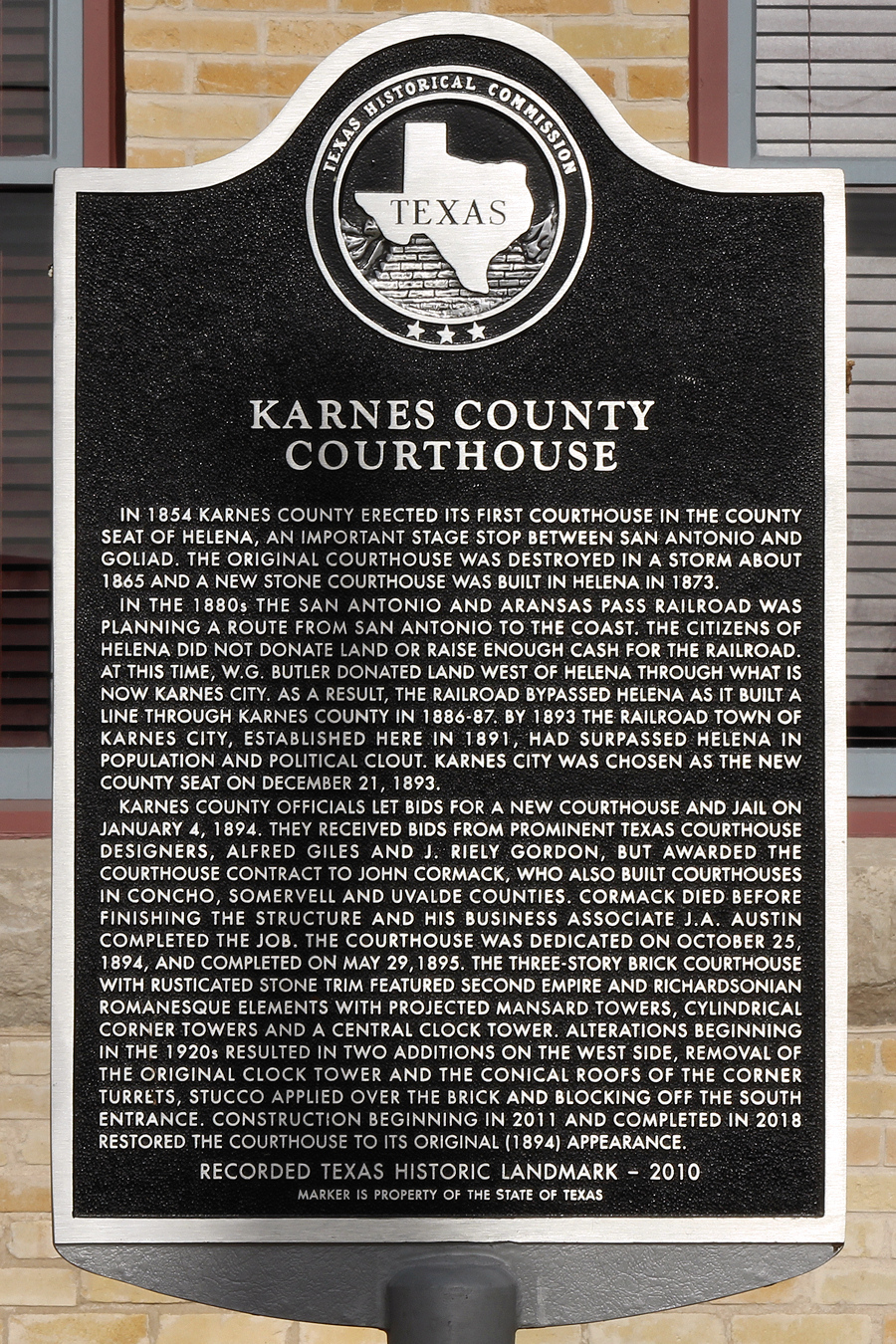
In 1894, as a result of a special election, the county seat was moved from Helena to Karnes City. Ten years earlier, Colonel William G. Butler (1831–1912) had blamed Helena and its corrupt mayor for the death of his son, Emmett, who was killed on December 26, 1884, by a stray bullet from a bar fight. Butler, a wealthy rancher, retaliated by arranging for the San Antonio and Aransas Pass Railway, which started construction in 1885, to bypass Helena.
The railway started operation in 1886. By 1890, with no rail line, Helena was at a disadvantage for serving the county's needs. In 1890, a group of businessmen purchased land on the rail line, 7 miles (11 km) southwest of Helena, with the specific intent of building a new town to serve as the county seat. The new town, named for Colonel Henry Wax Karnes (1812–1840), veteran of the Texas Revolution and a leader of the Texas Rangers, was a viable settlement by 1894, when the county voted to move its seat from Helena. Karnes City continued to grow, while Helena faded into a ghost town.
The story was fictionalized in the 1969 episode "The Oldest Law" of the television series Death Valley Days. In the episode, Jim Davis played the role of Colonel Butler, while Stacy Harris played Helena's mayor.
From the History section of Karnes City, Texas on Wikipedia, under CC BY-SA 4.0.
Churches and places of worship7
Saint Cornelius Catholic Church
Church · Roman Catholic
605 East Calvert Avenue, Karnes City
Gas and EV charging2
Schools, colleges and libraries14
Map of Karnes City
41 places. The map loads OpenStreetMap tiles when you open it.
Climate by month
Monthly table
| Month | High | Low | Rain | Snow |
|---|---|---|---|---|
| Jan | 65°F | 43°F | 1.9 in | 0.0 in |
| Feb | 68°F | 46°F | 1.5 in | 0.0 in |
| Mar | 74°F | 52°F | 2.3 in | 0.0 in |
| Apr | 82°F | 59°F | 2.7 in | 0.0 in |
| May | 88°F | 66°F | 3.6 in | 0.0 in |
| Jun | 93°F | 72°F | 3.4 in | 0.0 in |
| Jul | 96°F | 74°F | 2.9 in | 0.0 in |
| Aug | 97°F | 73°F | 2.3 in | 0.0 in |
| Sep | 91°F | 69°F | 3.5 in | 0.0 in |
| Oct | 83°F | 60°F | 2.8 in | 0.0 in |
| Nov | 74°F | 51°F | 2.2 in | 0.0 in |
| Dec | 66°F | 44°F | 1.9 in | 0.4 in |
U.S. Climate Normals 1991-2020 for Karnes City 2N (2 mi away), rain and snow from Runge, NOAA NCEI.
People and cost of living
American Community Survey 5-year estimates, 2020-2024, U.S. Census Bureau. Estimates have margins of error, larger for small towns.
Disaster history
Karnes County has had 12 federal disaster declarations since 2000, most often for hurricanes.
- 2021-02-19: Severe Winter Storms (Severe Ice Storm)
- 2021-02-14: Severe Winter Storm (Severe Ice Storm)
- 2020-03-25: Covid-19 Pandemic (Biological)
- 2020-03-13: Covid-19 (Biological)
- 2017-08-25: Hurricane Harvey (Hurricane)
- 2008-03-14: Wildfires (Fire)
OpenFEMA disaster declarations summaries.
Getting there and nearby towns
Chase Field Industrial (NIR) is the nearest airport with scheduled flights listed in OpenStreetMap, 39 miles away.
- Beeville 34 mi south, about 55 min by car
- Goliad 34 mi southeast, about 55 min by car
- Pleasanton 36 mi west, about 59 min by car
- Jourdanton 39 mi west, about 1 h by car
- George West 41 mi south, about 1 h by car
- Seguin 49 mi north, about 1 h 15 min by car
- Converse 50 mi northwest, about 1 h 15 min by car
- Cibolo 51 mi north, about 1 h 15 min by car
- Schertz 51 mi northwest, about 1 h 30 min by car
- San Antonio 55 mi northwest, about 1 h 30 min by car
Drive times are estimates from straight-line distance, not routes.
Local news
Headlines from INDB, the NEMICO news database.
Reviews, tips and questions
Loading what members have shared...
Sources and licences
- NCES EDGE (Public domain): public schools
- NOAA NCEI U.S. Climate Normals 1991-2020 (Public domain): climate by month
- OpenFEMA (Public domain): disaster declarations
- OpenStreetMap contributors (ODbL 1.0): places, airports, map data
- U.S. Census Bureau (Public domain): population, income, housing, education, commute
- Wikidata (CC0 1.0): elevation, founding date, time zone, website
- Wikimedia Commons (see each image): photos
- Wikipedia (CC BY-SA 4.0): overview and history text
Photo credits
- The north elevation of the Karnes County, Texas Courthouse in Karnes City, Texas, United States. The courthouse was recently restored to its original (1894) appearance, Larry D. Moore, CC BY 4.0
- Karnes County Texas Courthouse East Elevation 2018, Larry D. Moore, CC BY 4.0
- Karnes courthouse, Larry D. Moore, CC BY 4.0
- Karnes County Courthouse Historical Marker, Larry D. Moore, CC BY 4.0
- Karnes County Texas Courthouse South Elevation 2018, Larry D. Moore, CC BY 4.0
- ISS030-E-20719 - View of Earth, Earth Science and Remote Sensing Unit , Lyndon B. Johnson Space Center, Public domain
Page built October 30, 2026. Spotted a mistake? Tell us or suggest a place.