
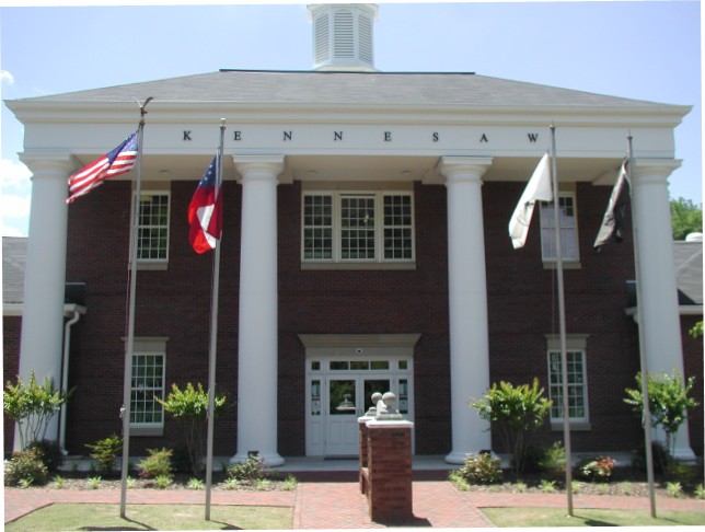


Why visit Kennesaw
Townapedia lists 22 museums and landmarks, 28 parks and trails, 159 places to eat, 13 places to stay and 9 attractions in and around town.
Highlights include Bagwell College of Education, Kennesaw State University College of Arts, Southern Museum of Civil War and Locomotive History and Acworth Downtown Historic District.
July is the warmest month, with average highs of 90°F; January lows average 31°F.
Weather in Kennesaw
Forecast from the National Weather Service. Full forecast
About Kennesaw
Kennesaw is a suburban city northwest of Atlanta in Cobb County, Georgia, United States, located within the greater Atlanta metropolitan area. Known from its original settlement in the 1830s until 1887 as Big Shanty, it became Kennesaw under an 1887 charter. According to the 2020 census, Kennesaw had a population of 33,036, a 10.9% increase in population over the preceding decade. Kennesaw has an important place in railroad history.
From the Wikipedia article Kennesaw, Georgia (this version), under CC BY-SA 4.0.
Things to do9

Kennesaw State University College of Humanities and Social Sciences
School · 2.2 mi
Kennesaw State University College of Science & Mathematics
School · 2.2 mi

Museums and landmarks22

Southern Museum of Civil War and Locomotive History
Museum · 0.6 mi
2829 Cherokee Street Northwest, Kennesaw
Mo-Sa 09:30-17:00; Su 11:00-18:00; Jan 01 off; easter off; Nov...

Acworth Downtown Historic District
Monument and historic site · National Register of Historic Places · 4.1 mi
United States historic place
Braswell-Carnes House
Monument and historic site · National Register of Historic Places · 4.5 mi
House in Cobb County, Georgia, United States
Kennesaw Mountain National Battlefield Park
Monument and historic site · National Register of Historic Places · 4.1 mi
Heritage site in Kennesaw, Georgia, USA
Western and Atlantic 3 “General”
Monument and historic site · National Register of Historic Places · 0.7 mi
Preserved American 4-4-0 locomotive
The Artful Rabbit Bookstore and Art Studio
Museum · 0.7 mi
2881 Shirley Drive
Mo,Su off; Tu-Sa 10:00-17:00
The Museum of History and Holocaust Education
Museum · 2.7 mi
3333 Busbee Drive Northwest, Kennesaw
Mo-Fr 10:00-16:00
10 more on the map.
Parks, trails and playgrounds28

Smith-Gilberrt Gardens
Park · 1.5 mi
2382 Pine Mountain Road Northwest, Kennesaw
Tu-Sa 09:00-16:00; Jan 01 closed; Dec 24-25 closed
Big Shanty Park
Park · 1.9 mi
2050 Kennesaw Due West Road Northwest, Kennesaw
06:00-23:00


16 more on the map.
Restaurants and cafes159

Big Shanty Smokehouse
Restaurant · Barbecue · 0.9 mi
3393 Cherokee Street Northwest, Kennesaw
We-Th 11:00-19:00; Fr-Sa 11:00-20:30
1885 Grill
Restaurant · Regional · 0.7 mi
2840 South Main Street, Kennesaw
Mo-Sa 11:00-21:00; Su 11:00-20:00
Asian Fusion Chinese Thai & Sushi
Restaurant · Chinese, Sushi, Thai · 2.9 mi
1635 Old 41 Highway Northwest
Mo off; Tu-Th 11:00-22:00; Fr-Sa 11:00-22:30; Su 11:00-22:00

Caper's Restaurant & Bar
Diner · American · 2.9 mi
1635 Old 41 Highway Northwest
Mo-Tu off; We-Su 11:00-22:00

Caribou Coffee
Cafe · Coffee Shop, Breakfast · 2.4 mi
3280 Barrett Lakes Boulevard
Mo-Fr 05:00-20:00; Sa-Su 06:00-20:00
Chioma's African Cuisine
Restaurant · African · 0.9 mi
2655 Cobb Parkway
Mo off; Tu-Sa 12:00-21:00; Su 04:00-21:00
Cracker Barrel
Diner · American · 2.7 mi
3389 Busbee Drive Northwest, Kennesaw
Su-Th 06:00-22:00; Fr-Sa 06:00-23:00
El Taco Azteca
Restaurant · Mexican · 0.9 mi
2689 Summers Street Northwest
Tu-Sa 11:00-22:00; Su 11:00-21:00; Mo off
Elevation Chophouse
Diner · American · 1.6 mi
1723 McCollum Parkway Northwest
We-Fr 17:00-22:00; Sa 11:00-15:00,16:00-22:00; Su 11:00-15:00,16:00-21:00
Fern Gully Jamaican Cafe
Restaurant · Jamaican, Caribbean · 0.8 mi
2756 South Main Street Northwest
Mo,Su off; Tu-Th 11:00-20:00; Fr 11:00-21:00; Sa 12:00-20:00
First Watch
Restaurant · American, Breakfast · 1.6 mi
3815 Cherokee Street Northwest, Kennesaw
07:00-14:30
147 more on the map.
History
As the Western and Atlantic Railroad was being built in the late 1830s, shanty towns arose to house the workers. These were near a big spring. A grade up from the Etowah River became known as "the big grade to the shanties", then "Big Shanty Grade", and finally "Big Shanty". It was officially incorporated as the city of Kennesaw in 1887.
From the History section of Kennesaw, Georgia on Wikipedia, under CC BY-SA 4.0.
Where to stay13
Comfort Suites at Kennesaw State University
Motel and hotel · 2.8 mi
3366 Busbee Drive Northwest, Kennesaw
Fairfield Inn & Suites Atlanta Kennesaw
Motel and hotel · 2.6 mi
3425 Busbee Drive Northwest, Kennesaw
Sonesta ES Suites Atlanta Kennesaw Town Center
Motel and hotel · 2.6 mi
3443 Busbee Drive Northwest, Kennesaw
SpringHill Suites Atlanta Kennesaw
Motel and hotel · 2.3 mi
3399 Town Point Drive Northwest, Kennesaw
Sleep Inn & Suites At Kennesaw State University
Motel and hotel · 2.3 mi
1454 George Busbee Parkway Northwest, Kennesaw
TownePlace Suites Atlanta Kennesaw
Motel and hotel · 2.8 mi
1074 Cobb Place Boulevard Northwest, Kennesaw
Churches and places of worship25
Saint Catherine of Siena Catholic Church
Church · Roman Catholic · 1.2 mi
1618 Ben King Road Northwest, Kennesaw
Mt. Pisgah Seventh-Day Adventist Church
Church · Seventh Day Adventist · 1.0 mi
2751 South Main Street
Shopping16
Gas and EV charging25
Schools, colleges and libraries38
Saint Catherine of Siena Catholic School
School · Roman Catholic · 1.3 mi
1618 Ben King Road Northwest, Kennesaw
Healthcare15
Kaiser Permanente Townpark Comprehensive Medical Center
Clinic and pharmacy · 2.8 mi
750 Townpark Lane Northwest, Kennesaw
Kennesaw Health and Wellness Chiropractic
Clinic and pharmacy · 1.3 mi
3655 Cherokee Street Northwest, Kennesaw
Tia Hydrate Health And Wellness Center
Clinic and pharmacy · 1.6 mi
3772 Cherokee Street Northwest, Kennesaw
Wellstar Kennesaw Medical Center
Clinic and pharmacy · 1.6 mi
3805 Cherokee Street Northwest, Kennesaw
Map of Kennesaw
250 places. The map loads OpenStreetMap tiles when you open it.
Climate by month
Monthly table
| Month | High | Low | Rain | Snow |
|---|---|---|---|---|
| Jan | 52°F | 31°F | 4.9 in | 0.8 in |
| Feb | 57°F | 34°F | 5.1 in | 0.7 in |
| Mar | 65°F | 40°F | 5.1 in | 1.2 in |
| Apr | 74°F | 48°F | 4.3 in | 0.1 in |
| May | 81°F | 56°F | 4.0 in | 0.0 in |
| Jun | 87°F | 65°F | 4.7 in | 0.0 in |
| Jul | 90°F | 68°F | 4.8 in | 0.0 in |
| Aug | 89°F | 68°F | 4.2 in | 0.0 in |
| Sep | 84°F | 61°F | 4.4 in | 0.0 in |
| Oct | 74°F | 50°F | 3.4 in | 0.0 in |
| Nov | 64°F | 39°F | 4.4 in | 0.0 in |
| Dec | 55°F | 34°F | 5.0 in | 1.0 in |
U.S. Climate Normals 1991-2020 for Dallas 7 Ne (8 mi away), NOAA NCEI.
People and cost of living
American Community Survey 5-year estimates, 2020-2024, U.S. Census Bureau. Estimates have margins of error, larger for small towns.
Disaster history
Cobb County has had 12 federal disaster declarations since 2000, most often for hurricanes.
- 2026-10-09: Hurricane Isaias (Tropical Storm)
- 2026-01-24: Severe Winter Storm (Winter Storm)
- 2024-09-26: Hurricane Helene (Tropical Storm)
- 2020-03-29: Covid-19 Pandemic (Biological)
- 2020-03-13: Covid-19 (Biological)
- 2017-09-15: Hurricane Irma (Hurricane)
OpenFEMA disaster declarations summaries.
Getting there and nearby towns
Dobbins Air Reserve Base (MGE) is the nearest airport with scheduled flights listed in OpenStreetMap, 10 miles away.
- Acworth 4 mi northwest, about 6 min by car
- Holly Springs 12 mi northeast, about 20 min by car
- Cartersville 14 mi northwest, about 22 min by car
- Dallas 15 mi southwest, about 24 min by car
- Sandy Springs 16 mi southeast, about 26 min by car
- Canton 17 mi northeast, about 27 min by car
- Dunwoody 19 mi east, about 30 min by car
- Alpharetta 20 mi east, about 32 min by car
- Brookhaven 20 mi southeast, about 32 min by car
- Atlanta 22 mi southeast, about 35 min by car
Drive times are estimates from straight-line distance, not routes.
Local news
Headlines from INDB, the NEMICO news database.
Reviews, tips and questions
Loading what members have shared...
Sources and licences
- NCES EDGE (Public domain): public schools
- NOAA NCEI U.S. Climate Normals 1991-2020 (Public domain): climate by month
- OpenFEMA (Public domain): disaster declarations
- OpenStreetMap contributors (ODbL 1.0): places, airports, map data
- U.S. Census Bureau (Public domain): population, income, housing, education, commute
- Wikidata (CC0 1.0): elevation, founding date, time zone, website, landmarks and historic places
- Wikimedia Commons (see each image): photos
- Wikipedia (CC BY-SA 4.0): overview and history text
Photo credits
- KennesawCityHall, Davepies at English Wikipedia, Public domain
- Deerfield Park Trail bridge, Kennesaw GA, John Phelan, CC BY 4.0
- Little Free Library along Deerfield Park Trail, Kennesaw GA, John Phelan, CC BY 4.0
- Deerfield Drive bridge over Proctor Creek, Kennesaw GA, John Phelan, CC BY 4.0
- Winchester Forest Park Trail bridge over Proctor Creek, Kennesaw GA, John Phelan, CC BY 4.0
- Winchester Forest Park, Kennesaw GA, John Phelan, CC BY 4.0
- Winchester Forest Park Trail steps, Kennesaw GA, John Phelan, CC BY 4.0
- Adams Park, Kennesaw GA, John Phelan, CC BY 4.0
- Swift Cantrell Park perimeter loop, Kennesaw GA, John Phelan, CC BY 4.0
- Former Kennesaw Branch Library, Kennesaw GA, John Phelan, CC BY 4.0
- Kennesaw City Hall, Tyler Lahti, CC BY-SA 4.0
- Kennesaw State University graduates receive salute from Georgia Army Guard Commander (5383140391), Georgia National Guard from United States, CC BY 2.0
- Assault on Kennesaw Mountain (22332100335), Georgia National Guard from United States, CC BY 2.0
- Swift Cantrell Park picnic shelter, Kennesaw GA, John Phelan, CC BY 4.0
- Little Free Library at Swift Cantrell Park, Kennesaw GA, John Phelan, CC BY 4.0
- Winchester Forest Park Trail bench, Kennesaw GA, John Phelan, CC BY 4.0
- Winchester Forest Park Trail, Kennesaw GA, John Phelan, CC BY 4.0
- Site - Lacy Hotel historical marker, Kennesaw GA, John Phelan, CC BY 4.0
- Big Shanty historical marker, Kennesaw GA, John Phelan, CC BY 4.0
- Kennesaw State Social Science Building, Thejerm, CC BY 3.0
- NorthMainStreet, Nilesrob, CC BY-SA 4.0
- My baby Labradorite (5681406880), Leah Gia from Marietta, GA, CC BY 2.0
- First to the Top (11018374656), Georgia National Guard from United States, CC BY 2.0
- Carrying the Guidon (22145261809), Georgia National Guard from United States, CC BY 2.0
- Photo Finish (11018376066), Georgia National Guard from United States, CC BY 2.0
- Reverse SRP stronger than ever (6097257506), Georgia National Guard from United States, CC BY 2.0
- The Top is Taken (11018375576), Georgia National Guard from United States, CC BY 2.0
- Power Stroller (11018507173), Georgia National Guard from United States, CC BY 2.0
- 100324-N-2257C-004 (4557272033), United States Navy Band from Washington, D.C., USA, Public domain
- Running up the Mountain (21709346614), Georgia National Guard from United States, CC BY 2.0
- 100324-N-2257C-001 (4557902904), United States Navy Band from Washington, D.C., USA, Public domain
- Take That Hill (11018447004), Georgia National Guard from United States, CC BY 2.0
- Honoring Their Service (11018508193), Georgia National Guard from United States, CC BY 2.0
- BigShanty, Nilesrob, CC BY-SA 4.0
- The GENERAL at Big Shanty in Front of Lacy Hotel Where Andrews Raiders Took it, April 12, 1862 (1), Gary Todd, CC0
- The GENERAL Model in O Gauge, Gary Todd, CC0
- The GENERAL at Big Shanty in Front of Lacy Hotel Where Andrews Raiders Took it, April 12, 1862, Gary Todd, CC0


Page built October 30, 2026. Spotted a mistake? Tell us or suggest a place.