


Kingston, New Jersey
Kingston is a community of 1,670 people in Middlesex County, New Jersey.
Why visit Kingston
Townapedia lists 20 museums and landmarks, 10 parks and trails, 3 places to eat, 4 places to stay and 5 attractions in and around town.
Highlights include Kingston Bridge, Liechtenstein Institute on Self-Determination, Delaware and Raritan Canal and Donald Grant Herring Estate.
July is the warmest month, with average highs of 87°F; January lows average 21°F, and about 24 inches of snow fall in a normal year.
Weather in Kingston
Forecast from the National Weather Service. Full forecast
About Kingston
Kingston is an unincorporated community and census-designated place (CDP) along the border of South Brunswick Township in Middlesex County and Franklin Township in Somerset County, and also located relatively near Princeton in Mercer County in the U.S. state of New Jersey. The historic settlement is in the Raritan Valley region, located along the course of the Millstone River. As of the 2020 census, the CDP's population was 1,581, of which 1,272 were in South Brunswick Township and 309 in Franklin Township.
From the Wikipedia article Kingston, New Jersey (this version), under CC BY-SA 4.0.
Things to do5

Kingston Bridge
Bridge · 0.6 mi
Historic bridge in Kingston, New Jersey

Liechtenstein Institute on Self-Determination
School · 3.1 mi
Research institution based at Princeton, New Jersey, USA

Princeton University
School · 3.3 mi
Private Ivy League research university in Princeton, New Jersey, United States
Princeton University Department of History
School · 3.1 mi
Academic department
Princeton University School of Engineering and Applied Science
School · 2.9 mi
School in New Jersey, US
Museums and landmarks20

Delaware and Raritan Canal
Monument and historic site · National Register of Historic Places · 2.0 mi
Canal in New Jersey, United States of America and a historic company to build this

Donald Grant Herring Estate
Monument and historic site · National Register of Historic Places · 2.7 mi
Historic house in New Jersey, United States

Joseph Henry House
Monument and historic site · National Register of Historic Places · 3.2 mi
House in New Jersey, United States of America

Jugtown Historic District
Monument and historic site · National Register of Historic Places · 2.5 mi
Historic district in Princeton, New Jersey

Kingston Mill Historic District
Monument and historic site · National Register of Historic Places · 0.6 mi
Historic district in Kingston, New Jersey

Maybury Hill
Monument and historic site · National Register of Historic Places · 1.7 mi
Historic home in Princeton, New Jersey

Nassau Hall
Monument and historic site · National Register of Historic Places · 3.3 mi
Building in Princeton, New Jersey, United States

President's House
Monument and historic site · National Register of Historic Places · 3.3 mi
Historic house at Princeton University
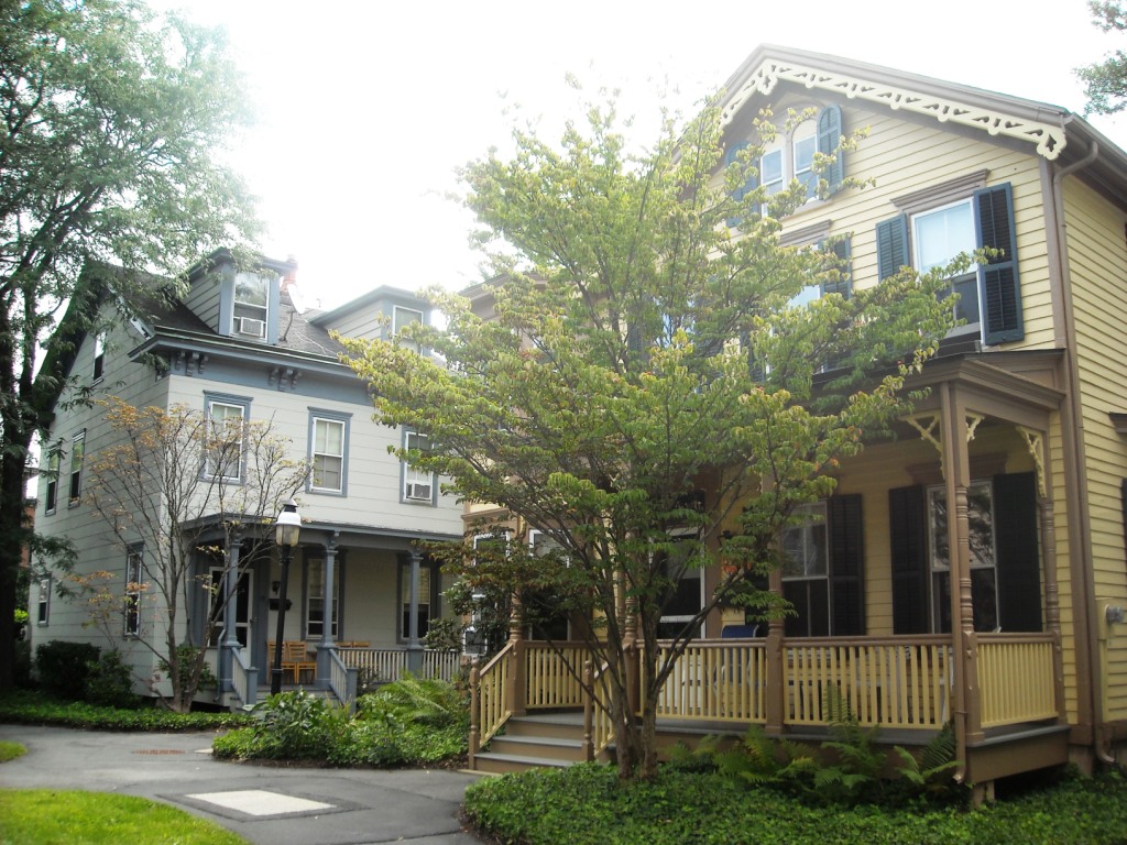
Princeton Historic District
Monument and historic site · National Register of Historic Places · 3.3 mi
Historic district in Princeton, New Jersey

Princeton Nurseries
Monument and historic site · National Register of Historic Places · 0.9 mi
Historic plant nursery near Kingston, New Jersey

Prospect House
Monument and historic site · National Register of Historic Places · 3.3 mi
Princeton, New Jersey, also known simply as Prospect, a National Historic Landmark and NRHP-listed


Red Maple Farm
Monument and historic site · National Register of Historic Places · 1.2 mi
Historic house in New Jersey, United States
8 more on the map.
Parks, trails and playgrounds10


Restaurants and cafes3

Urban Spice
Restaurant · Indian · 0.4 mi
4591 Main Street, Kingston
Mo-Th 11:30-21:00; Fr-Sa 11:30-22:00; Su 11:30-21:00
History
Jediah Higgins purchased 1,000 acres (4.0 km2) from the Native Americans in the early 18th century and the town of Kingston was established. Kingston's location on the Lenape Assunpink Trail where it crossed the Millstone River and later becoming part of the King's Highway was the prime factor in its early prominence. Kingston was by far the most active and important village, being situated on both the heavily traveled King's Road and Millstone River, combining commercial activities of both mills and taverns.
From the History section of Kingston, New Jersey on Wikipedia, under CC BY-SA 4.0.
Where to stay4
Churches and places of worship9
Shopping1
Gas and EV charging1
Schools, colleges and libraries35
Brooks Crossing Elementary School
School · 5.6 mi
50 Deans Rhode Hall Road, Monmouth Junction
Crossroads North Middle School
School · 4.8 mi
635 Georges Road, Monmouth Junction
Map of Kingston
88 places. The map loads OpenStreetMap tiles when you open it.
Climate by month
Monthly table
| Month | High | Low | Rain | Snow |
|---|---|---|---|---|
| Jan | 40°F | 21°F | 3.5 in | 5.8 in |
| Feb | 43°F | 23°F | 2.6 in | 8.0 in |
| Mar | 51°F | 30°F | 4.3 in | 4.6 in |
| Apr | 63°F | 39°F | 3.7 in | 0.6 in |
| May | 73°F | 48°F | 4.1 in | 0.0 in |
| Jun | 82°F | 58°F | 4.6 in | 0.0 in |
| Jul | 87°F | 63°F | 4.8 in | 0.0 in |
| Aug | 85°F | 61°F | 4.3 in | 0.0 in |
| Sep | 78°F | 54°F | 4.2 in | 0.0 in |
| Oct | 66°F | 42°F | 4.0 in | 0.0 in |
| Nov | 55°F | 33°F | 3.3 in | 0.3 in |
| Dec | 46°F | 27°F | 4.2 in | 4.4 in |
U.S. Climate Normals 1991-2020 for Hightstown 2 W Hcn (8 mi away), NOAA NCEI.
People and cost of living
American Community Survey 5-year estimates, 2020-2024, U.S. Census Bureau. Estimates have margins of error, larger for small towns.
Disaster history
Middlesex County has had 17 federal disaster declarations since 2000, most often for hurricanes.
- 2021-09-05: Remnants Of Hurricane Ida (Hurricane)
- 2021-09-02: Remnants Of Hurricane Ida (Hurricane)
- 2020-03-25: Covid-19 Pandemic (Biological)
- 2020-03-13: Covid-19 (Biological)
- 2016-03-14: Severe Winter Storm And Snowstorm (Severe Storm)
- 2012-10-30: Hurricane Sandy (Hurricane)
OpenFEMA disaster declarations summaries.
Getting there and nearby towns
Princeton Airport (PCT) is the nearest airport with scheduled flights listed in OpenStreetMap, 2 miles away.
- Heathcote 2 mi east, about 3 min by car
- Princeton 3 mi southwest, about 5 min by car
- Kendall Park 3 mi northeast, about 6 min by car
- Princeton Meadows 4 mi southeast, about 7 min by car
- Deans 5 mi east, about 9 min by car
- Franklin Park 6 mi northeast, about 9 min by car
- Dayton 6 mi east, about 9 min by car
- Belle Mead 6 mi north, about 10 min by car
- Blackwells Mills 7 mi north, about 11 min by car
- Cranbury 7 mi southeast, about 11 min by car
Drive times are estimates from straight-line distance, not routes.
Local news
Headlines from INDB, the NEMICO news database.
Reviews, tips and questions
Loading what members have shared...
Sources and licences
- NCES EDGE (Public domain): public schools
- NOAA NCEI U.S. Climate Normals 1991-2020 (Public domain): climate by month
- OpenFEMA (Public domain): disaster declarations
- OpenStreetMap contributors (ODbL 1.0): places, airports, map data
- U.S. Census Bureau (Public domain): population, income, housing, education, commute
- Wikidata (CC0 1.0): elevation, founding date, time zone, website, landmarks and historic places
- Wikimedia Commons (see each image): photos
- Wikipedia (CC BY-SA 4.0): overview and history text
Photo credits
- 4577 State Highway 27, Kingston, NJ, Jerrye & Roy Klotz, MD, CC BY-SA 4.0
- Into kingston - panoramio, Henry P. Gray, CC BY-SA 3.0
- Community room in the Laurel Avenue School in Kingston, New Jersey on November 5, 2019, Richard Arthur Norton (1958- ), CC BY-SA 4.0
- Auditorium at the Laurel Avenue School in Kingston, New Jersey on November 5, 2019, Richard Arthur Norton (1958- ), CC BY-SA 4.0
- New schoolhouse at the Laurel Avenue School in Kingston, New Jersey on November 5, 2019, Richard Arthur Norton (1958- ), CC BY-SA 4.0
- Entrance to the Laurel Avenue School in Kingston, New Jersey on November 5, 2019, Richard Arthur Norton (1958- ), CC BY-SA 4.0
- New schoolhouse of the Laurel Avenue School in Kingston, New Jersey on November 5, 2019, Richard Arthur Norton (1958- ), CC BY-SA 4.0
- Old schoolhouse of the Laurel Avenue School in Kingston, New Jersey on November 5, 2019, Richard Arthur Norton (1958- ), CC BY-SA 4.0
- Old schoolhouse of the Laurel Avenue School in Kingston, New Jersey on March 9, 2021, Richard Arthur Norton (1958- ), CC BY-SA 4.0
- Kingston Presbyterian Church 0019, Richard Arthur Norton (1958- ), CC BY-SA 4.0
- Kingston Presbyterian Church 0021, Richard Arthur Norton (1958- ), CC BY-SA 4.0
- Kingston Presbyterian Church 0020, Richard Arthur Norton (1958- ), CC BY-SA 4.0
- Kingston Presbyterian Church in Kingston, New Jersey on October 31, 2019, Richard Arthur Norton (1958- ), CC BY-SA 4.0
- Kingston Presbyterian Church 0022, Richard Arthur Norton (1958- ), CC BY-SA 4.0
- Kingston United Methodist Church 0262, Richard Arthur Norton (1958- ), CC BY-SA 4.0
- Kingston United Methodist Church 0261, Richard Arthur Norton (1958- ), CC BY-SA 4.0
- Kingston United Methodist Church 0260, Richard Arthur Norton (1958- ), CC BY-SA 4.0
- Kingston United Methodist Church 0263, Richard Arthur Norton (1958- ), CC BY-SA 4.0
- Kingston Presbyterian Church cemetery 0259, Richard Arthur Norton (1958- ), CC BY-SA 4.0
- Kingston Presbyterian Church cemetery 0258, Richard Arthur Norton (1958- ), CC BY-SA 4.0
- Established in 1675, The Village of Kingston straddles Franklin Township and South Brunswick Township and lies partially in Somerset, Mercer, and Middlesex County along the Deleware and Raritan Canal..., Gary Miotla, CC BY 3.0
- University Cottage Club Princeton, Smallbones, CC0
- Princeton Historic District-089, Elisa.rolle, CC BY-SA 3.0
- 91 Washington Street, Rocky Hill, NJ - historic Dutch Reformed Church, Zeete, CC BY-SA 4.0
- Withington Estate, Middlesex County, Jerrye & Roy Klotz, MD, CC BY-SA 4.0
- Nassau Hall Princeton, Smallbones, CC0
- Jugtown Princeton, Smallbones, CC0
- Delaware & Raritan Canal seen from footbridge, Tomwsulcer, CC0
- WITHERSPOON STREET SCHOOL FOR COLORED CHILDREN; PRINCETON, MERCER COUNTY, Jerrye & Roy Klotz, MD, CC BY-SA 3.0
- GULICK HOUSE, MIDDLESEX COUNTY, NJ, Jerrye & Roy Klotz, MD, CC BY-SA 4.0
- Princeton University Prospect, Quantockgoblin 18:27, 2 December 2006 (UTC), Public domain
- Maclean house, Fullmetal2887, CC BY-SA 3.0
- Princeton Nurseries, Middlesex County, NJ - Sales and Administration Building, Zeete, CC BY-SA 4.0
- Maybury-hill-princeton, Dmadeo, CC BY-SA 3.0
- Kingston Mill, Kingston, New Jersey, Zeete, CC BY-SA 4.0
- DONALD G. HERRING ESTATE, MERCER COUNTY, NJ, Jerrye & Roy Klotz, MD, CC BY-SA 3.0
- Joseph Henry House-072, Elisa.rolle, CC BY-SA 3.0
- TUSCULUM, PRINCETON, MERCER COUNTY, NJ, Jerrye & Roy Klotz, MD, CC BY-SA 3.0
- An autumn view of Cleveland tower at the Graduate College, Princeton University. label QS:Len,"An autumn view of Cleveland tower at the Graduate College, Princeton University.", Magneticcarpet, CC BY-SA 3.0
- Stone Hill Church Cross, David Keddie, CC BY-SA 4.0


Page built October 30, 2026. Spotted a mistake? Tell us or suggest a place.