


Knoxville, Tennessee
Knoxville is a city of 195,185 people in Knox County, Tennessee, founded in 1786.
Why visit Knoxville
Townapedia lists 128 museums and landmarks, 70 parks and trails, 247 places to eat, 14 places to stay and 20 attractions in and around town.
Highlights include Bijou Theatre, Tennessee Theatre, Knoxville Museum of Art and Women's Basketball Hall of Fame.
July is the warmest month, with average highs of 88°F; January lows average 26°F.
Weather in Knoxville
Forecast from the National Weather Service. Full forecast
About Knoxville
Knoxville is a city in Knox County, Tennessee, United States, and its county seat. Located on the Tennessee River within the Appalachian Mountains, it is the largest city in the Grand Division of East Tennessee. Knoxville had a population of 190,740 at the 2020 census, making it the third-most-populous city in Tennessee. The Knoxville metropolitan area has an estimated 958,000 residents.
From the Wikipedia article Knoxville, Tennessee (this version), under CC BY-SA 4.0.
Things to do20

Bijou Theatre
Cinema and theater · National Register of Historic Places · 1.9 mi
Theater and former movie theater in Knoxville, Tennessee, United States
803 South Gay Street


Crown College
School · 5.8 mi
Baptist Bible college and seminary in Powell, Tennessee


Sunsphere
Monument and historic site · 1.6 mi
Observation tower in Knoxville, Tennessee, United States
University of Tennessee
School · 1.7 mi
Public university in Knoxville, Tennessee, United States

8 more on the map.
Museums and landmarks128

Knoxville Museum of Art
Museum · 1.5 mi
Museum in Tennessee, United States
1050 Worlds Fair Park Drive, Knoxville
Tu-Sa 10:00-17:00; Su 13:00-17:00


Central United Methodist Church
Monument and historic site · Methodist · National Register of Historic Places · 1.6 mi
Church building in Tennessee, United States of America
201 3rd Avenue, Knoxville

Knoxville College
Monument and historic site · National Register of Historic Places
Liberal arts college in Knoxville, Tennessee

L&N Station
Monument and historic site · National Register of Historic Places · 1.5 mi
Former Louisville and Nashville Railroad station in Knoxville, Tennessee

Lincoln Park United Methodist Church
Monument and historic site · Methodist · National Register of Historic Places · 2.2 mi
Church building in Knoxville, United States of America
3120 Pershing Street Northeast, Knoxville
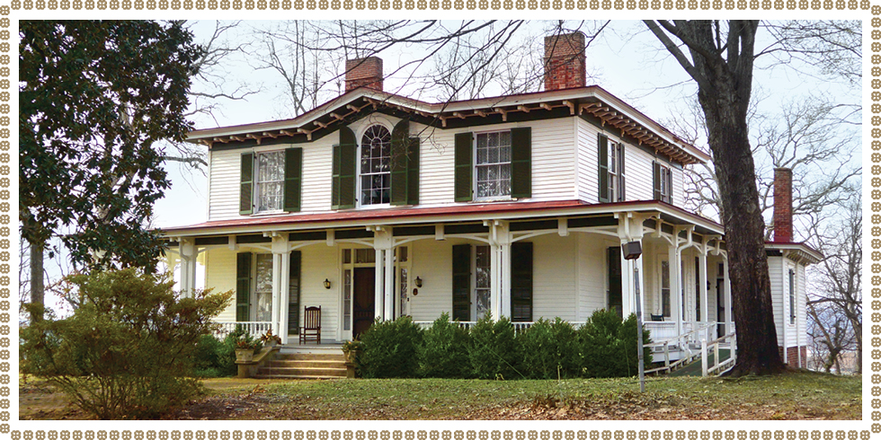
Mabry-Hazen House
Monument and historic site · National Register of Historic Places · 2.6 mi
Historic US home in Knoxville, Tennessee
1711 Dandridge Avenue Southeast, Knoxville

Market Square
Monument and historic site · National Register of Historic Places · 1.7 mi
Pedestrian mall and historic district in Knoxville, Tennessee

Middlebrook
Monument and historic site · National Register of Historic Places · 1.6 mi
Historic house in Knoxville, Tennessee


University of Tennessee Agriculture Farm Mound
Monument and historic site · National Register of Historic Places · 1.7 mi
Archaeological site in Knox County, United States of America
Airplane Service Station
Monument and historic site · National Register of Historic Places · 5.2 mi
Filling station in Knox County, Tennessee
116 more on the map.
Parks, trails and playgrounds70


Chilhowee Park
Park · 4.1 mi
Park in Tennessee, United States of America, United States of America
Covenant Health Park
Sports field and stadium · 2.0 mi
500 East Jackson Avenue, Knoxville
James Agee Dog Park
Park · 1.3 mi
Dog park with benches and free plastics bags for waste.
331 James Agee Street, Knoxville
sunrise-sunset
Neyland Stadium
Sports field and stadium · 1.7 mi
1235 Phillip Fulmer Way, Knoxville
Regal Soccer Stadium
Sports field and stadium · 1.9 mi
2317 Stephenson Drive, Knoxville
58 more on the map.
Restaurants and cafes247

Calhoun’s on the River
Restaurant · Barbecue, American · 2.0 mi
400 Neyland Drive
Su-Th 11:00-22:00; Fr-Sa 11:00-23:00
DiCarlo's Pizza - Knoxville
Restaurant · Pizza · 1.8 mi
The original square pizza shop. Established in 1945.
524 South Gay Street, Knoxville
Mo 11:00-15:00; Tu 11:00-20:00; We-Th 11:00-23:00; Fr 11:00-24:00;...
Not Watson's Kitchen + Bar
Restaurant · Southern · 1.7 mi
Retro haunt with vintage decor offering classic bar food with a modern twist & regional craft beers.
15 Market Square, Knoxville
Mo-Th 11:00-22:00; Fr-Sa 11:00-23:00; Su 11:00-21:00
Panda Chinese Restaurant
Restaurant · Asian, Chinese · 2.1 mi
4424 Western Avenue
Mo-Sa 11:00-22:30; Su 12:00-22:30

STIR
Diner · American · 1.8 mi
Located in Old City Knoxville, STIR features scratch-made dishes, fresh oysters and seafood from its raw bar, and craft cocktails made...
217 Willow Avenue, Knoxville
Mo-Th 11:00-23:30, Fr 11:00-25:00, Sa 10:00-25:00, Su 10:00-23:30
Southern Grit
Diner · American · 1.7 mi
Southern and lowcountry inspired cuisine in Knoxville’s historic Old City.
126 South Central Street, Knoxville
Tu-Th 11:30-21:00; Fr 11:30-22:00; Sa 11:00-22:00; Su 11:00-21:00

Starbucks
Cafe · Coffee Shop · 1.7 mi
501 West Church Avenue, Knoxville
Mo-Sa 06:30-19:00, Su 06:30-15:00
Aladdin Pizza & Grill
Restaurant · Pizza · 1.3 mi
1723 Cumberland Avenue, Knoxville
Mo-Th 12:00-24:00, Fr-Sa 12:00-25:00, Su 17:00-23:00
Balter Beer Works
Restaurant · Burger · 1.4 mi
100 South Broadway, Knoxville
Mo-Th 11:00-11:00; Fr 11:00-00:00; Sa 10:00-00:00; Su 10:00-22:00
Barley's Taproom and Pizzeria
Restaurant · Pizza · 1.8 mi
200 East Jackson Avenue, Knoxville
Mo-Th 11:00-23:00; Fr-Sa 11:00-02:00; Su 12:00-23:00
Billie Rae's Soul Food and Catering
Restaurant · Barbecue · 2.5 mi
1920 East Magnolia Avenue
Tu-Sa 10:30-19:00; Su 12:00-18:00
235 more on the map.
Where to stay14
Andrew Johnson Hotel
Motel and hotel · 2.0 mi
912 South Gay Street, Knoxville
Cumberland House Knoxville, Tapestry Collection by Hilton
Motel and hotel · 1.5 mi
1109 White Avenue, Knoxville
Churches and places of worship88
Church Street United Methodist Church
Church · United Methodist · National Register of Historic Places · 1.8 mi
900 Henley Street, Knoxville
Immaculate Conception Catholic Church
Church · Roman Catholic · 1.6 mi
414 West Vine Avenue, Knoxville
First Baptist Church
Church · National Register of Historic Places · 1.9 mi
Greater Warner Tabernacle AME Zion Church, Knoxville
Church · 4.5 mi
Shopping23
Gas and EV charging11
Schools, colleges and libraries70
Mcclung, E.Tn History Center & Knox Archives
Library · 1.8 mi
600;601 Market Street Southwest;South Gay Street, Knoxville
Healthcare12
Lakeway Urgent Care
Clinic and pharmacy · 1.5 mi
2461 University Commons Way, Knoxville
Passport Health Knoxville Travel Clinic
Clinic and pharmacy · 2.5 mi
1378 Papermill Pointe Way, Knoxville
Map of Knoxville
250 places. The map loads OpenStreetMap tiles when you open it.
Climate by month
Monthly table
| Month | High | Low | Rain |
|---|---|---|---|
| Jan | 48°F | 26°F | 5.2 in |
| Feb | 52°F | 29°F | 5.1 in |
| Mar | 61°F | 36°F | 5.3 in |
| Apr | 71°F | 44°F | 5.2 in |
| May | 78°F | 54°F | 4.5 in |
| Jun | 86°F | 62°F | 4.0 in |
| Jul | 88°F | 66°F | 5.8 in |
| Aug | 88°F | 65°F | 3.4 in |
| Sep | 83°F | 59°F | 4.1 in |
| Oct | 72°F | 46°F | 3.0 in |
| Nov | 61°F | 35°F | 4.1 in |
| Dec | 51°F | 30°F | 5.9 in |
U.S. Climate Normals 1991-2020 for Knoxville Exp Stn (5 mi away), NOAA NCEI.
People and cost of living
American Community Survey 5-year estimates, 2020-2024, U.S. Census Bureau. Estimates have margins of error, larger for small towns.
Disaster history
Knox County has had 15 federal disaster declarations since 2000, most often for severe storms.
- 2026-02-06: Severe Winter Storm (Winter Storm)
- 2026-01-24: Severe Winter Storm (Winter Storm)
- 2025-04-02: Severe Storms, Straight-Line Winds, Tornadoes, And Flooding (Severe Storm)
- 2023-09-27: Severe Storms, Straight-Line Winds, And Tornado (Severe Storm)
- 2023-03-08: Severe Winter Storm (Winter Storm)
- 2020-04-02: Covid-19 Pandemic (Biological)
OpenFEMA disaster declarations summaries.
Getting there and nearby towns
McGhee Tyson Airport (TYS) (TYS) is the nearest airport with scheduled flights listed in OpenStreetMap, 11 miles away.
- Powell 6 mi northwest, about 10 min by car
- Halls 8 mi north, about 12 min by car
- John Sevier 8 mi northeast, about 13 min by car
- Karns 9 mi west, about 14 min by car
- Rockford 9 mi south, about 15 min by car
- Alcoa 11 mi south, about 17 min by car
- Seymour 12 mi southeast, about 20 min by car
- Louisville 12 mi southwest, about 19 min by car
- Mascot 12 mi northeast, about 20 min by car
- Eagleton Village 13 mi south, about 20 min by car
Drive times are estimates from straight-line distance, not routes.
Local news
Headlines from INDB, the NEMICO news database.
Reviews, tips and questions
Loading what members have shared...
Sources and licences
- NCES EDGE (Public domain): public schools
- NOAA NCEI U.S. Climate Normals 1991-2020 (Public domain): climate by month
- OpenFEMA (Public domain): disaster declarations
- OpenStreetMap contributors (ODbL 1.0): places, airports, map data
- U.S. Census Bureau (Public domain): population, income, housing, education, commute
- Wikidata (CC0 1.0): elevation, founding date, time zone, website, landmarks and historic places
- Wikimedia Commons (see each image): photos
- Wikipedia (CC BY-SA 4.0): overview and history text
Photo credits
- Downtown Knoxville (cropped), Will Fisher, CC BY-SA 2.0
- The headquarters of the Knoxville News Sentinel newspaper pictured on April 24, 2014 in Tennessee, Harrison Keely, CC BY 4.0
- Race and ethnicity 2010- Knoxville (5560424300), Eric Fischer, CC BY-SA 2.0
- Headquarters for the Knoxville News Sentinel newspaper and KnoxNews.com in Tennessee, Harrison Keely, CC BY 4.0
- I-275 Knoxville, Bneu2013, CC0
- Happy Holler Historic District in Knoxville, TN, United States 01, TomasVial, CC BY 4.0
- Happy Holler Historic District in Knoxville, TN, United States 02, TomasVial, CC BY 4.0
- Facade Sears Roebuck Building in Knoxville 01, TomasVial, CC BY 4.0
- Facade Sears Roebuck Building in Knoxville 02, TomasVial, CC BY 4.0
- Facade Sears Roebuck Building in Knoxville 03, TomasVial, CC BY 4.0
- Old Louisville and Nashville Railroad Freight Station, World’s Fair Park Drive, Knoxville, TN - 52473769484, w_lemay, CC BY-SA 2.0
- Old Louisville and Nashville Railroad Freight Station, World’s Fair Park Drive, Knoxville, TN - 52473769414, w_lemay, CC BY-SA 2.0
- World’s Fair Park, Knoxville, TN - 52473489026, w_lemay, CC BY-SA 2.0
- No Kings demonstration in Knoxville from Western Avenue, Jonathan Schilling, CC BY-SA 4.0
- World’s Fair Park, Knoxville, TN - 52473951715, w_lemay, CC BY-SA 2.0
- Old Louisville and Nashville Railroad Passenger Station, Henley Street and Western Avenue, Knoxville, TN - 52472990292, w_lemay, CC BY-SA 2.0
- Knoxville Iron Foundry Complex-Nail Factory and Warehouse, World’s Fair Park Drive, Knoxville, TN - 52472990677, w_lemay, CC BY-SA 2.0
- Knoxville Iron Foundry Complex-Nail Factory and Warehouse, World’s Fair Park Drive, Knoxville, TN, w_lemay, CC BY-SA 2.0
- Old Louisville and Nashville Railroad Passenger Station, Henley Street and Western Avenue, Knoxville, TN - 52472990247, w_lemay, CC BY-SA 2.0
- KMA Knox, Ɱ, CC BY-SA 4.0
- Church Street United Methodist Church - Knoxville, Tennessee - April 19, 2014, Lee Ann Ratledge, CC BY 4.0
- Bijou-theater-lamar-house-tn1, Brian Stansberry, CC BY 3.0
- Historic-homes-mabry-hazen-house-photo1, Mabryhazenhouse, CC BY-SA 4.0
- Middlebrook-knoxville-tn1, Brian Stansberry, CC BY 3.0
- Central-united-methodist-church-tn1, Brian Stansberry, CC BY 3.0
- Knoxville-college-mckee-tn1, Brian Stansberry, CC BY 3.0
- Ut-ag-farm-mound-tn1, Brian Stansberry (photographer), CC BY 3.0
- Louisville-and-nashville-nw-entrance-knox-tn1, Brian Stansberry (photographer), CC BY 3.0
- Lincoln-park-methodist-church-tn1, Brian Stansberry, CC BY 3.0
- Market-square-north-tn1, Brian Stansberry, CC BY 3.0
- Bloom, Rob Upchurch, CC BY 3.0
- Wasp, Rob Upchurch, CC BY 3.0
- A Different Place, Rob Upchurch, CC BY 3.0
- Sunset Blossom, Rob Upchurch, CC BY 3.0
- The Fly, Rob Upchurch, CC BY 3.0
- Bacon (5386463383), Panegyrics of Granovetter from Toronto, Ontario, Canada, CC BY-SA 2.0
- 2016 election graffiti, Kinseikun, CC BY-SA 4.0
- Stand Out, Rob Upchurch, CC BY 3.0
- TN Knox County Happy Holler Historic District 0009, TennesseeNR, CC BY-SA 3.0
- Parson Brownlow grave, TomasVial, CC BY 4.0


Page built October 30, 2026. Spotted a mistake? Tell us or suggest a place.