


Lake Holm, Washington
Lake Holm is a community of 3,555 people in King County, Washington.
Why visit Lake Holm
Townapedia lists 8 museums and landmarks, 15 parks and trails, 9 places to eat, 2 places to stay and 2 attractions in and around town.
Highlights include Patton Bridge, Auburn Masonic Temple, Auburn Public Library and Cameron Park.
August is the warmest month, with average highs of 77°F; December lows average 32°F.
Weather in Lake Holm
Forecast from the National Weather Service. Full forecast
About Lake Holm
Lake Holm is a census-designated place (CDP) in King County, Washington, United States. As of the 2020 census, Lake Holm had a population of 3,430.
From the Wikipedia article Lake Holm, Washington (this version), under CC BY-SA 4.0.
Things to do2

Patton Bridge
Bridge · National Register of Historic Places · 1.8 mi
Historic bridge near Auburn, Washington, United States

Museums and landmarks8

Auburn Masonic Temple
Monument and historic site · National Register of Historic Places · 4.5 mi
Historic building in Auburn, Washington, United States

Auburn Public Library
Monument and historic site · National Register of Historic Places · 4.6 mi
Former Carnegie library in Auburn, Washington

Neely Mansion
Monument and historic site · National Register of Historic Places · 2.3 mi
Building in Washington, United States

Old Auburn Post Office
Monument and historic site · National Register of Historic Places · 4.5 mi
Historic post office building in Washington state, USA

Oscar Blomeen House
Monument and historic site · National Register of Historic Places · 4.5 mi
Historic house in Washington, United States
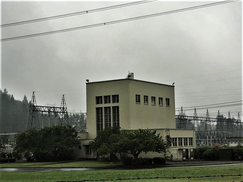
Covington Electrical Substation, Bonneville Power Administration
Monument and historic site · National Register of Historic Places · 3.0 mi


White River Valley Museum
Museum · 4.2 mi
History museum in Auburn, Washington

Parks, trails and playgrounds15


3 more on the map.
Restaurants and cafes9




Subway
Fast food · Sandwich · 2.3 mi
12722 Southeast 312th Street, Auburn
Mo-Sa 08:00-23:00, Su 09:00-22:00
Where to stay2
Churches and places of worship7
Auburn Adventist Academy Church
Church · Seventh Day Adventist · 2.4 mi
5010 Auburn Way South, Auburn
Cornerstone Gospel Church
Church · Catholic · 0.7 mi
15315 Southeast Auburn Black Diamond Road, Auburn
Family of Grace Lutheran Church
Church · Protestant · 2.4 mi
31317 124th Avenue Southeast, Auburn
Solid Ground Christian Fellowship
Church · Protestant · 2.4 mi
31204 124th Avenue Southeast, Auburn
The Church of Jesus Christ of Latter-day Saints
Church · Mormon · 2.0 mi
19107 Southeast Lake Holm Road, Auburn
Shopping3
Gas and EV charging4
Schools, colleges and libraries46
Map of Lake Holm
96 places. The map loads OpenStreetMap tiles when you open it.
Climate by month
Monthly table
| Month | High | Low | Rain |
|---|---|---|---|
| Jan | 46°F | 33°F | 8.0 in |
| Feb | 49°F | 33°F | 5.4 in |
| Mar | 53°F | 35°F | 6.2 in |
| Apr | 59°F | 38°F | 5.5 in |
| May | 66°F | 44°F | 3.9 in |
| Jun | 70°F | 48°F | 3.1 in |
| Jul | 77°F | 51°F | 1.3 in |
| Aug | 77°F | 52°F | 1.6 in |
| Sep | 71°F | 47°F | 2.8 in |
| Oct | 60°F | 41°F | 5.8 in |
| Nov | 50°F | 36°F | 8.5 in |
| Dec | 44°F | 32°F | 7.5 in |
U.S. Climate Normals 1991-2020 for Landsburg (9 mi away), NOAA NCEI.
People and cost of living
American Community Survey 5-year estimates, 2020-2024, U.S. Census Bureau. Estimates have margins of error, larger for small towns.
Disaster history
King County has had 18 federal disaster declarations since 2000, most often for severe storms.
- 2026-04-07: Severe Storms, Straight-Line Winds, Flooding, Landslides, And Mudslides (Flood)
- 2025-12-12: Severe Storms, Straight-Line Winds, Flooding, Landslides, And Mudslides (Flood)
- 2024-04-28: Severe Winter Storms, Straight-Line Winds, Flooding, Landslides, And Mudslides (Severe Storm)
- 2022-09-10: Bolt Creek Fire (Fire)
- 2020-04-23: Severe Storms, Flooding, Landslides, And Mudslides (Flood)
- 2020-03-22: Covid-19 Pandemic (Biological)
OpenFEMA disaster declarations summaries.
Getting there and nearby towns
Seattle-Tacoma International Airport (SEA) is the nearest airport with scheduled flights listed in OpenStreetMap, 13 miles away.
- Lake Morton-Berrydale 2 mi northeast, about 4 min by car
- Auburn 4 mi west, about 6 min by car
- Covington 4 mi north, about 7 min by car
- Maple Valley 6 mi northeast, about 10 min by car
- Lake Tapps 6 mi south, about 10 min by car
- Algona 6 mi west, about 9 min by car
- Kent 7 mi northwest, about 11 min by car
- Lakeland North 7 mi west, about 12 min by car
- Sumner 7 mi southwest, about 12 min by car
- Bonney Lake 8 mi south, about 12 min by car
Drive times are estimates from straight-line distance, not routes.
Local news
Headlines from INDB, the NEMICO news database.
Reviews, tips and questions
Loading what members have shared...
Sources and licences
- NCES EDGE (Public domain): public schools
- NOAA NCEI U.S. Climate Normals 1991-2020 (Public domain): climate by month
- OpenFEMA (Public domain): disaster declarations
- OpenStreetMap contributors (ODbL 1.0): places, airports, map data
- U.S. Census Bureau (Public domain): population, income, housing, education, commute
- Wikidata (CC0 1.0): elevation, founding date, time zone, website, landmarks and historic places
- Wikimedia Commons (see each image): photos
- Wikipedia (CC BY-SA 4.0): overview and history text
Photo credits
- 2022-07-26, Lake Holm of King County, Washington, 06, Steven Pavlov, CC BY-SA 4.0
- 2022-07-26, Lake Holm of King County, Washington, 05, Steven Pavlov, CC BY-SA 4.0
- 2022-12-29, Lake Holm of King County, Washington, 03, Steven Pavlov, CC BY-SA 4.0
- 2022-12-29, Lake Holm of King County, Washington, 02, Steven Pavlov, CC BY-SA 4.0
- 2022-07-26, Lake Holm of King County, Washington, 07, Steven Pavlov, CC BY-SA 4.0
- 2022-07-26, Lake Holm of King County, Washington, 01, Steven Pavlov, CC BY-SA 4.0
- 2022-07-26, Lake Holm of King County, Washington, 04, Steven Pavlov, CC BY-SA 4.0
- 2022-07-26, Lake Holm of King County, Washington, 02, Steven Pavlov, CC BY-SA 4.0
- 2022-07-26, Lake Holm of King County, Washington, 03, Steven Pavlov, CC BY-SA 4.0
- 2022-12-29, Lake Holm of King County, Washington, 01, Steven Pavlov, CC BY-SA 4.0
- Lodge picture1, Hadrian1982, CC BY-SA 4.0
- 2022-11-20, Neely Mansion, Auburn, Washington, 02, Steven Pavlov, CC BY-SA 4.0
- Auburn, WA - former post office 01A, Joe Mabel, CC BY-SA 3.0
- Auburn, WA - Auburn Dance Center 02, Joe Mabel, CC BY-SA 3.0
- Auburn, WA - Oscar Blomeen House 01, Joe Mabel, CC BY-SA 3.0
- Patton Bridge (Robin Bruce) 01, Robin Bruce, Public domain
- Covington Electrical Substation, BPA, NRHP 100002475 King County, WA, Jon Roanhaus, CC BY-SA 4.0
- Auburn, WA — White River Valley Museum, Steven Pavlov, CC BY-SA 4.0
- 2022-08-31, Covington Creek, 02, Steven Pavlov, CC BY-SA 4.0
- 2022-08-31, Covington Creek, 01, Steven Pavlov, CC BY-SA 4.0
- 2022-08-31, Covington Creek, 03, Steven Pavlov, CC BY-SA 4.0
- Porsche 911 GT3 (22247552465), Curt Smith from Bellevue, WA, USA, CC BY 2.0
- Motorcycle track day Pacific Raceways green bike, elenchos from Seattle, USA, CC BY 2.0
- Motorcycle track day, Pacific Raceways, Kent, WA, elenchos from Seattle, USA, CC BY 2.0
- 2022-10-15, Little Free Library, Auburn, Washington, 01, Senapa, CC BY-SA 4.0
- 2022-10-15, Little Free Library, Auburn, Washington, 03, Steven Pavlov, CC BY-SA 4.0
- 2022-10-15, Little Free Library, Auburn, Washington, 02, Steven Pavlov, CC BY-SA 4.0
- 2025-01-30, Little Free Library (Auburn, Washington), 075307, Steven Pavlov, CC BY-SA 4.0
- 2025-01-30, Little Free Library (Auburn, Washington), 075322, Steven Pavlov, CC BY-SA 4.0
- 2025-01-30, Little Free Library (Auburn, Washington), 075251, Steven Pavlov, CC BY-SA 4.0
- 2025-01-30, Little Free Library (Auburn, Washington), 075300, Steven Pavlov, CC BY-SA 4.0
- NHRA Drag Races (4811559844), RVWithTito.com from United States, CC BY 2.0
- NHRA Drag Races (4810938463), RVWithTito.com from United States, CC BY 2.0
- NHRA Drag Races (4810936935), RVWithTito.com from United States, CC BY 2.0
- NHRA Drag Races (4811546596), RVWithTito.com from United States, CC BY 2.0
- Cold Today, Dana Hutchinson, CC BY 3.0
- Patton Bridge, Jon Roanhaus, CC BY-SA 3.0
- Pacific Raceways aerial view, Tedder, CC BY 4.0
- 2022-12-29, The Church of Jesus Christ of Latter-day Saints, Auburn, Washington, 02, Steven Pavlov, CC BY-SA 4.0
- 2022-12-29, The Church of Jesus Christ of Latter-day Saints, Auburn, Washington, 01, Steven Pavlov, CC BY-SA 4.0


Page built October 30, 2026. Spotted a mistake? Tell us or suggest a place.