


Laredo, Texas
Laredo is a city of 257,619 people in Webb County, Texas, founded in 1755.
Why visit Laredo
Townapedia lists 74 museums and landmarks, 60 parks and trails, 207 places to eat, 26 places to stay and 9 attractions in and around town.
Highlights include Lamar Bruni Vergara Environmental Science Center, Cinemark Mall Del Norte, Barrio Azteca Historic District and Fort McIntosh.
August is the warmest month, with average highs of 101°F; January lows average 47°F.
Weather in Laredo
Forecast from the National Weather Service. Full forecast
About Laredo
Laredo (English pronunciation: /ləˈɹeɪdoʊ/ ; Spanish pronunciation: [laˈɾeðo] ) is a city in the U.S. state of Texas and the county seat and largest city of Webb County, on the north bank of the Rio Grande in South Texas, across from Nuevo Laredo, Tamaulipas, Mexico. Founded in 1755, Laredo grew from a village to the capital of the short-lived Republic of the Rio Grande to the largest inland port on the Mexican border. Laredo's economy is primarily based on international trade with Mexico, and as a major hub for three areas of transportation: land, rail, and air cargo. The city is on the southern end of I-35, which connects manufacturers in northern Mexico through Interstate 35 as a major route for trade throughout the U.S.
From the Wikipedia article Laredo, Texas (this version), under CC BY-SA 4.0.
Things to do9

Lamar Bruni Vergara Environmental Science Center
Zoo and aquarium · 4.1 mi
Taylor Road, Laredo
Mo-Th 08:00-18:00; Fr 08:00-12:00


Gateway to the Americas International Bridge
Bridge · 4.4 mi
Toll bridge
Juárez–Lincoln International Bridge
Bridge · 4.2 mi
International bridge connecting Laredo, Texas, and Laredo, Tamaulipas, on the US–Mexico border
Texas Mexican Railway International Bridge
Bridge · 4.6 mi
Bridge in Nuevo Laredo, Tamaulipas
World Trade International Bridge
Bridge · 3.9 mi
Bridge linking the US and Mexico

Museums and landmarks74

Barrio Azteca Historic District
Monument and historic site · National Register of Historic Places · 4.0 mi
Historic district in Laredo, Webb County, Texas

Fort McIntosh
Monument and historic site · National Register of Historic Places · 4.3 mi
Historic district in Laredo, Webb County, Texas

San Agustin de Laredo Historic District
Monument and historic site · National Register of Historic Places · 4.1 mi
Historic district in Laredo, Webb County, Texas
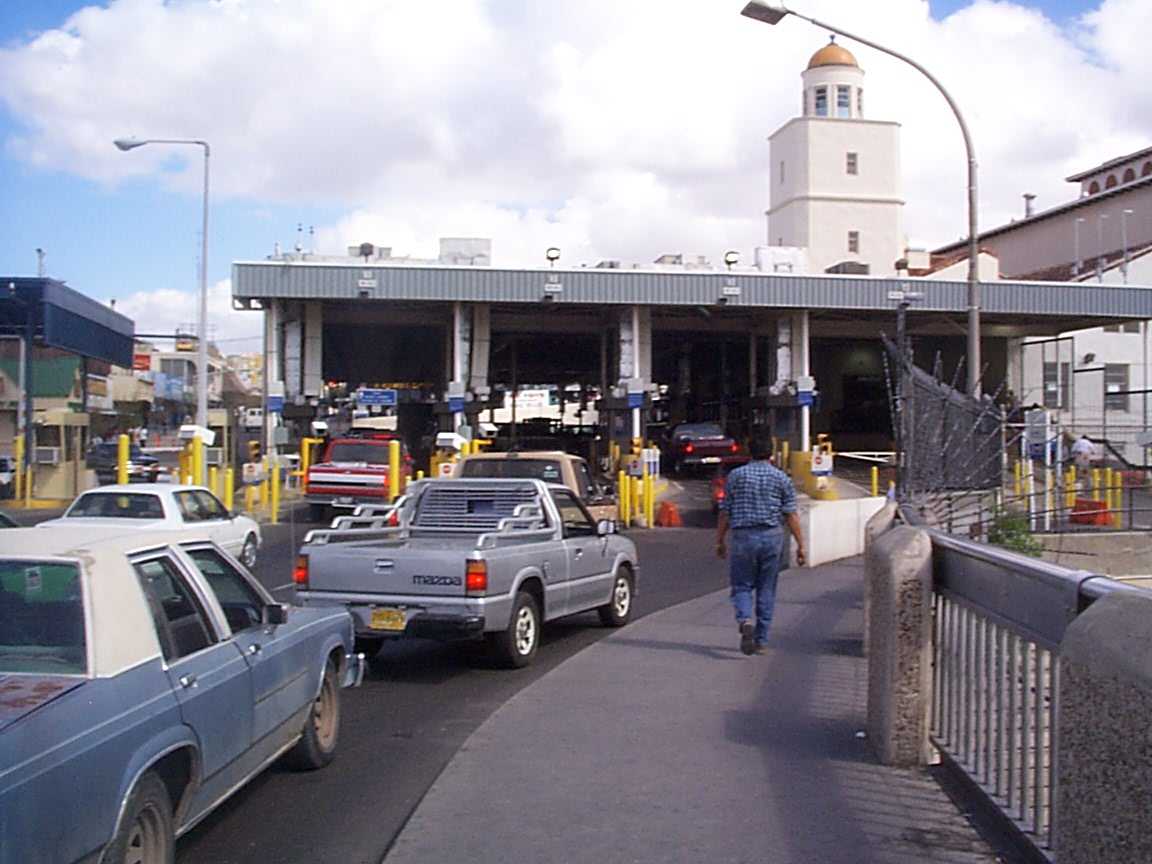
Laredo Convent Avenue Port of Entry
Monument and historic site · National Register of Historic Places · 4.2 mi
Building in Laredo, Webb County, Texas

Laredo United States Post Office, Court House and Custom House
Monument and historic site · National Register of Historic Places · 3.9 mi
Building in Laredo, Webb County, Texas


Webb County Courthouse
Monument and historic site · National Register of Historic Places · 3.8 mi
Building in Laredo, Webb County, Texas

Los Olvidados Art Gallery
Museum · 4.1 mi
309 Flores Avenue, Laredo
Th 12:00-19:00; Fr-Sa 10:00-20:00; Su 12:00-17:00
62 more on the map.
Parks, trails and playgrounds60

Camp Huisache
Park · 4.1 mi
"This 30-acre camp has 6 campsites, program shelters and a new 10,000 square foot administration and conference center that also...
Lake Casa Blanca International State Park
Park · 3.3 mi
5102 Bob Bullock Loop, Laredo
Fr-Su 08:00-17:00

Parque la Junta
Park · 5.7 mi
Baseball field in Nuevo Laredo, Tamaulipas, Mexico
Uni-Trade Stadium
Sports field and stadium · 2.1 mi
6320 Sinatra Parkway, Laredo

Casa Balnca Golf Course
Golf course · 2.8 mi
3900 Casa Blanca Road, Laredo
Mo-Sa 07:00-19:00; Su 07:30-19:00
48 more on the map.
Restaurants and cafes207


ALA Burger - Burgers and Alitas
Restaurant · Burger, Wings, American · 4.0 mi
515 San Agustin Avenue, Laredo
Tu-Sa 11:00-21:00; Su 11:00-18:00

Casa de Frida - House of Breakfast
Restaurant · Breakfast · 1.1 mi
1010 East Hillside Road, Laredo
Tu-Sa 08:00-15:00
Charlie's Corona
Restaurant · American, Salad, Tex-Mex, Steak House · 2.0 mi
3902 San Bernardo Avenue, Laredo
Mo-Su 11:30-21:00
Los Olvidados
Cafe · Tea, Coffee, Sandwich · 4.1 mi
309 Flores Avenue, Laredo
Th 12:00-19:00; Fr-Sa 10:00-20:00; Su 12:00-17:00
195 more on the map.
History
The Spanish colonial settlement of Villa de San Agustín de Laredo was founded in 1755 by Don Tomás Sánchez de la Barrera, while the area was part of the Nuevo Santander region in the Spanish viceroyalty of New Spain. Villa de San Agustín de Laredo was named after Laredo, Cantabria, Spain and in honor of Saint Augustine of Hippo. In 1840, Laredo was the capital of the independent Republic of the Rio Grande, set up in opposition to Antonio López de Santa Anna; it was brought back into Mexico by military force.
In 1846 during the Mexican–American War, the town was occupied by the Texas Rangers. After the war, the Treaty of Guadalupe-Hidalgo ceded the land to the United States. A referendum was taken in the town, which voted to petition the American military government in charge of the area to return the town to Mexico. When this petition was rejected, many who had been in the area for generations, moved across the river into Mexican territory, where they founded Nuevo Laredo. Many others, especially original land grantees on the north side of the Rio Grande remained, becoming Texans in the process. In 1849, the United States Army set up Fort McIntosh (originally Camp Crawford). Laredo was rechartered as a city in 1852.
From the History section of Laredo, Texas on Wikipedia, under CC BY-SA 4.0.
Where to stay26
Churches and places of worship41
Saint Peter the Apostle Catholic Church
Church · Roman Catholic · 3.9 mi
1510 Matamoros Street, Laredo
Blessed Sacrament Catholc Church
Church · Roman Catholic · 3.6 mi
2219 Galveston Street, Laredo
Holy Family Catholic Church
Church · Roman Catholic · 2.8 mi
2702 North Stone Avenue, Laredo
Holy Redeemer Catholic Church
Church · Roman Catholic · 3.5 mi
1602 Garcia Street, Laredo
Our Lady of Guadalupe Catholic Church
Church · Roman Catholic · 3.2 mi
1718 San Jorge Avenue, Laredo
Shopping45
Gas and EV charging39
Schools, colleges and libraries101
Healthcare22
STAT Specialty Hospital Laredo North Location
Hospital · 3.9 mi
2502 Northeast Bob Bullock Loop, Laredo
Map of Laredo
250 places. The map loads OpenStreetMap tiles when you open it.
Climate by month
Monthly table
| Month | High | Low | Rain | Snow |
|---|---|---|---|---|
| Jan | 68°F | 47°F | 0.8 in | 0.0 in |
| Feb | 74°F | 52°F | 0.7 in | 0.0 in |
| Mar | 81°F | 58°F | 1.3 in | 0.0 in |
| Apr | 88°F | 65°F | 1.3 in | 0.0 in |
| May | 94°F | 72°F | 2.8 in | 0.0 in |
| Jun | 99°F | 76°F | 1.8 in | 0.0 in |
| Jul | 100°F | 77°F | 1.9 in | 0.0 in |
| Aug | 101°F | 77°F | 1.6 in | 0.0 in |
| Sep | 94°F | 73°F | 3.9 in | 0.0 in |
| Oct | 87°F | 66°F | 1.7 in | 0.0 in |
| Nov | 76°F | 56°F | 1.0 in | 0.0 in |
| Dec | 69°F | 48°F | 1.1 in | 0.1 in |
U.S. Climate Normals 1991-2020 for Laredo 2 (1 mi away), NOAA NCEI.
People and cost of living
American Community Survey 5-year estimates, 2020-2024, U.S. Census Bureau. Estimates have margins of error, larger for small towns.
Disaster history
Webb County has had 19 federal disaster declarations since 2000, most often for hurricanes.
- 2026-07-18: Flooding (Flood)
- 2024-07-09: Hurricane Beryl (Hurricane)
- 2021-02-19: Severe Winter Storms (Severe Ice Storm)
- 2021-02-14: Severe Winter Storm (Severe Ice Storm)
- 2020-07-26: Hurricane Hanna (Hurricane)
- 2020-03-25: Covid-19 Pandemic (Biological)
OpenFEMA disaster declarations summaries.
Getting there and nearby towns
Laredo International Airport (LRD) is the nearest airport with scheduled flights listed in OpenStreetMap, 2 miles away.
- Los Altos 8 mi southeast, about 13 min by car
- Ranchos Penitas West 11 mi northwest, about 17 min by car
- Pueblo Nuevo 12 mi southeast, about 19 min by car
- Rio Bravo 14 mi south, about 22 min by car
- El Cenizo 16 mi south, about 25 min by car
- Encinal 34 mi north, about 55 min by car
- San Ygnacio 35 mi south, about 57 min by car
- Medina 45 mi south, about 1 h 15 min by car
- Zapata 48 mi south, about 1 h 15 min by car
- Hebbronville 52 mi east, about 1 h 30 min by car
Drive times are estimates from straight-line distance, not routes.
Local news
Headlines from INDB, the NEMICO news database.
Reviews, tips and questions
Loading what members have shared...
Sources and licences
- NCES EDGE (Public domain): public schools
- NOAA NCEI U.S. Climate Normals 1991-2020 (Public domain): climate by month
- OpenFEMA (Public domain): disaster declarations
- OpenStreetMap contributors (ODbL 1.0): places, airports, map data
- U.S. Census Bureau (Public domain): population, income, housing, education, commute
- Wikidata (CC0 1.0): elevation, founding date, time zone, website, landmarks and historic places
- Wikimedia Commons (see each image): photos
- Wikipedia (CC BY-SA 4.0): overview and history text
Photo credits
- Laredo US Post Office, Court House and Custom House, JoshDavid Photos, CC BY-SA 4.0
- Snow in Laredo Texas, Miguel Angel Omaña Rojas, CC BY 4.0
- Laredo Medical Center IMG 1768, Billy Hathorn at en.wikipedia, CC BY-SA 3.0
- Greetings from Laredo, Texas - Large Letter Postcard (7780213888), Steve Shook from Moscow, Idaho, USA, CC BY 2.0
- Greetings from Laredo, Texas - Large Letter Postcard (19689342951), Steve Shook from Moscow, Idaho, USA, CC BY 2.0
- Race and ethnicity 2010- Laredo (5560424532), Eric Fischer, CC BY-SA 2.0
- Greetings from Laredo, Texas - Large Letter Postcard (7999407243), Steve Shook from Moscow, Idaho, USA, CC BY 2.0
- Rio Grande river Laredo, Miguel Angel Omaña Rojas, CC BY 4.0
- ASCEND for Better Health Community Engagement Event in Laredo, TX (20230331-REE-PRA-01), USDAgov, Public domain
- ASCEND for Better Health Community Engagement Event in Laredo, TX (20230331-REE-PRA-37), USDAgov, Public domain
- San Agustin Cathedral, AMAPO, CC BY 2.5
- ElAztecaSandstoneHouse, Jessevannaajar, CC BY-SA 3.0
- San Agustin Cathedral Tower, AMAPO, CC BY 2.5
- Laredo Post Office and Courthouse, Laredo, Texas, Carol M. Highsmith, Public domain
- Webb County Courthouse 2007, AMAPO, CC BY-SA 3.0
- TAMIU Water Fountain, lordsutch, CC BY-SA 2.0
- Laredo br1 port of entry, Wbaron, CC BY-SA 3.0
- Ostrea contracta amichel, Miguel Angel Omaña Rojas, CC0
- Compass (Front) - panoramio, Octavio Alonso Maya …, CC BY-SA 3.0
- Compass - panoramio, Octavio Alonso Maya …, CC BY-SA 3.0
- Banco Longoria, Tzy6m2, CC0
- IHop - panoramio, Octavio Alonso Maya …, CC BY-SA 3.0
- Sirloin Stockade - panoramio, Octavio Alonso Maya …, CC BY-SA 3.0
- U.S. Customs and Border Protection briefs Georgia Guard commanders (8242456306), Georgia National Guard from United States, CC BY 2.0
- You can run, but you can't hide... (8241387181), Georgia National Guard from United States, CC BY 2.0
- Illegal immigrant apprehended (8241387097), Georgia National Guard from United States, CC BY 2.0
- Georgia Guardsmen on the Border (8241387031), Georgia National Guard from United States, CC BY 2.0
- Patrolling the Rio Grande from the Air (8242455642), Georgia National Guard from United States, CC BY 2.0
- Fannie Ratchford 1970 0821 (10539866615), Texas State Archives, No restrictions
- Fannie Ratchford 1970 0822 (10539866876), Texas State Archives, No restrictions
- Sames Auto Arena, Sames Auto Arena, CC BY-SA 4.0
- Welty, Unknown, Public domain
- ISS054-E-16740 - View of Earth, Earth Science and Remote Sensing Unit, NASA Johnson Space Center, Public domain
- ISS006-E-17492 - View of Texas, Earth Science and Remote Sensing Unit , Lyndon B. Johnson Space Center, Public domain
- ISS054-E-16741 - View of Earth, Earth Science and Remote Sensing Unit, NASA Johnson Space Center, Public domain
- Ledger stone of Eusebio Garcia's presumed grave, JoeSanch1105, CC BY-SA 4.0
- Ledger stone(top) of Eusebio Garcia's presumed grave, JoeSanch1105, CC BY-SA 4.0
- March 14 2025 Total Lunar Eclipse, NuperSITE, CC0


Page built October 30, 2026. Spotted a mistake? Tell us or suggest a place.