


Laurel, Mississippi
Laurel is a city of 17,679 people in Jones County, Mississippi, founded in 1882.
Why visit Laurel
Townapedia lists 7 museums and landmarks, 17 parks and trails, 37 places to eat, 12 places to stay and 3 attractions in and around town.
Highlights include Southwest Theaters Sawmill Square 5, Laurel Central Historic District and Laurel station.
July is the warmest month, with average highs of 93°F; January lows average 35°F.
Weather in Laurel
Forecast from the National Weather Service. Full forecast
About Laurel
Laurel is a city in and the second county seat of Jones County, Mississippi, United States. As of the 2020 census, the city had a population of 17,161. Laurel is northeast of Ellisville, the first county seat, which contains the first county courthouse. It has the second county courthouse, as Jones County has two judicial districts.
From the Wikipedia article Laurel, Mississippi (this version), under CC BY-SA 4.0.
Things to do3


Museums and landmarks7

Laurel Central Historic District
Monument and historic site · National Register of Historic Places · 1.1 mi
Historic district in Laurel, Mississippi
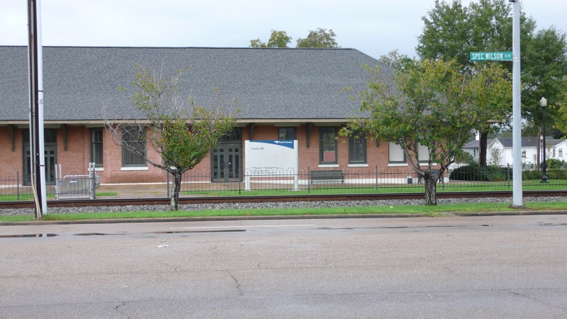
Laurel station
Monument and historic site · National Register of Historic Places · 1.2 mi
Amtrak station in downtown Laurel, Mississippi
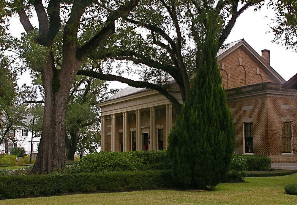
Lauren Rogers Museum of Art
Museum · 1.1 mi
Art museum in Laurel, Mississippi
565 North 5th Avenue, Laurel
Tu-Sa 10:00-16:45; Su 13:00-16:00


Newell Rogers House
Monument and historic site · National Register of Historic Places · 1.0 mi
Historic two-story house in Laurel, Mississippi

Parks, trails and playgrounds17



5 more on the map.
Restaurants and cafes37

Del Sol Mexican
Restaurant · Mexican
212 North 16th Avenue, Laurel
Su-Th 11:00-21:30; Fr-Sa 11:00-22:00

Hog Heaven BBQ
Restaurant · Barbecue · 2.0 mi
2515 Ellisville Boulevard, Laurel
Mo-We 04:30-20:00; Th-Sa 04:30-21:00
Julia's Taqueria
Restaurant · Mexican
304 North 16th Avenue, Laurel
Mo-Th 10:00-21:00; Fr-Sa 10:00-22:00
Pasquale's Italian Restaurant
Restaurant · Italian
303 North 16th Avenue, Laurel
Mo-Sa 11:00-16:00

Restaurante La Palma
Restaurant · Mexican
136 South 16th Avenue, Laurel

25 more on the map.
History
Following the 1881 construction of the New Orleans and Northeastern Railroad through the area, economic development occurred rapidly. The city of Laurel was incorporated in 1882, with timber as the impetus. Yellow pine forests in the region fueled the industry. The city was named for thickets of mountain laurel (Kalmia latifolia) native to the original town site.
Located in the heart of the piney woods ecoregion of the Southeastern United States, the land site that eventually became Laurel was densely covered with forests of virgin longleaf pine, making the area attractive to pioneering lumberjacks and sawmill operators in the late 19th century.
In 1881, business partners John Kamper and A.M. Lewin constructed a small lumber mill on the New Orleans and Northeastern Railroad. Kamper and Lewin's mill was in an area that later became Laurel's First Avenue. The next year, in response to a Post Office Department request to provide a postal delivery name for their mill and its surrounding lumber camp, Kamper and Lewin submitted the name "Lawrell" as an homage to the area's naturally growing mountain laurel bushes. Federal postal officials soon "corrected" the peculiar spelling, giving the town its current spelling.
From the History section of Laurel, Mississippi on Wikipedia, under CC BY-SA 4.0.
Where to stay12
Churches and places of worship55
Shopping8
Gas and EV charging6
Schools, colleges and libraries26
Healthcare2
South Central Urgent Care & Industrial Medicine
Clinic and pharmacy · 0.4 mi
1430 Jefferson Street, Laurel
Map of Laurel
173 places. The map loads OpenStreetMap tiles when you open it.
Climate by month
Monthly table
| Month | High | Low | Rain | Snow |
|---|---|---|---|---|
| Jan | 60°F | 35°F | 6.1 in | 0.0 in |
| Feb | 65°F | 38°F | 5.1 in | 0.0 in |
| Mar | 72°F | 45°F | 5.5 in | 0.0 in |
| Apr | 79°F | 52°F | 5.1 in | 0.0 in |
| May | 85°F | 60°F | 4.3 in | 0.0 in |
| Jun | 91°F | 68°F | 5.5 in | 0.0 in |
| Jul | 93°F | 70°F | 5.4 in | 0.0 in |
| Aug | 93°F | 70°F | 5.5 in | 0.0 in |
| Sep | 89°F | 64°F | 3.9 in | 0.0 in |
| Oct | 80°F | 52°F | 3.5 in | 0.0 in |
| Nov | 70°F | 42°F | 4.1 in | 0.0 in |
| Dec | 62°F | 37°F | 5.8 in | 0.0 in |
U.S. Climate Normals 1991-2020 for Laurel Hcn (2 mi away), NOAA NCEI.
People and cost of living
American Community Survey 5-year estimates, 2020-2024, U.S. Census Bureau. Estimates have margins of error, larger for small towns.
Disaster history
Jones County has had 23 federal disaster declarations since 2000, most often for hurricanes.
- 2026-02-06: Severe Winter Storm (Winter Storm)
- 2026-01-24: Severe Winter Storm (Winter Storm)
- 2023-08-12: Severe Storms, Straight-Line Winds, And Tornadoes. (Severe Storm)
- 2021-10-22: Hurricane Ida (Hurricane)
- 2021-08-28: Hurricane Ida (Hurricane)
- 2020-10-28: Hurricane Zeta (Hurricane)
OpenFEMA disaster declarations summaries.
Getting there and nearby towns
Hesler-Noble Field (LUL) is the nearest airport with scheduled flights listed in OpenStreetMap, 2 miles away.
- Ellisville 7 mi southwest, about 12 min by car
- Sharon 8 mi northeast, about 13 min by car
- Soso 9 mi northwest, about 14 min by car
- Sandersville 9 mi northeast, about 15 min by car
- Ovett 16 mi southeast, about 25 min by car
- Heidelberg 17 mi northeast, about 27 min by car
- Taylorsville 19 mi northwest, about 31 min by car
- Bay Springs 21 mi north, about 34 min by car
- Petal 24 mi south, about 39 min by car
- Hattiesburg 28 mi south, about 45 min by car
Drive times are estimates from straight-line distance, not routes.
Local news
Headlines from INDB, the NEMICO news database.
Reviews, tips and questions
Loading what members have shared...
Sources and licences
- NCES EDGE (Public domain): public schools
- NOAA NCEI U.S. Climate Normals 1991-2020 (Public domain): climate by month
- OpenFEMA (Public domain): disaster declarations
- OpenStreetMap contributors (ODbL 1.0): places, airports, map data
- U.S. Census Bureau (Public domain): population, income, housing, education, commute
- Wikidata (CC0 1.0): elevation, founding date, time zone, website, landmarks and historic places
- Wikimedia Commons (see each image): photos
- Wikipedia (CC BY-SA 4.0): overview and history text
Photo credits
- LaurelMississippiTrainStation, DwayneP, CC BY-SA 3.0
- 2021 04 16 Greetings from Laurel Mississippi, Pairko, CC BY-SA 4.0
- The Knight Butcher - Laurel, Mississippi, June 2025, Paul Lowry, CC BY 2.0
- The Odd Fellows Building - Laurel, Mississippi, June 2025, Paul Lowry, CC BY 2.0
- The Heirloom Hotel - Laurel, Mississippi, June 2025, Paul Lowry, CC BY 2.0
- Wisteria - Laurel, Mississippi, June 2025, Paul Lowry, CC BY 2.0
- Rogers-Green House - Laurel, Mississippi, June 2025, Paul Lowry, CC BY 2.0
- Watch your step - Laurel, Mississippi, June 2025, Paul Lowry, CC BY 2.0
- Laurel City Hall, Ahill.laurel, CC BY-SA 3.0
- We are Laurel, Ahill.laurel, CC BY-SA 3.0
- Lauren Rogers Museum of Art - Laurel, Mississippi, June 2025, Paul Lowry, CC BY 2.0
- Columns of the Lauren Rogers Museum of Art in Laurel, Mississippi, Paul Lowry, CC BY 2.0
- Black Marble Grand Staircase - Laurel, Mississippi, June 2025, Paul Lowry, CC BY 2.0
- Laurel, Mississippi Station 2024, Paul Lowry, CC BY 2.0
- Laurel MS 31 December 2024, Paul Lowry, CC BY 2.0
- Newell Rogers House Laurel, Credit: Courtesy of the Mississippi Department of Archives and History, Public domain
- Lauren Rogers museum, Michlaovic, Public domain
- Historic Wool worth Building, Ahill.laurel, CC BY-SA 3.0
- Lauren Rogers Museum of Art, Ahill.laurel, CC BY-SA 3.0
- 2021 04 16 Blind Roosevelt Graves Marker, Pairko, CC BY-SA 4.0
- Dante Marioni vase Febrary 2026 (cropped), MauraWen, CC0
- Dante Marioni vase Feb 2026, MauraWen, CC0
- Confederate Boy - 1862 painting in Lauren Rogers Museum of Art, Paul Lowry, Public domain
- Jones County Blues - Mississippi Blues Trail Marker, Firecruise, CC BY-SA 4.0
- STS126-E-22841 - View of Earth, NASA, Public domain
- ISS038-E-536 - View of Earth, Earth Science and Remote Sensing Unit , Lyndon B. Johnson Space Center, Public domain
- ISS062-E-144108 - View of Earth, Earth Science and Remote Sensing Unit, NASA Johnson Space Center, Public domain
- ISS060-E-975 - View of Earth, Earth Science and Remote Sensing Unit, NASA Johnson Space Center, Public domain
- ISS062-E-144107 - View of Earth, Earth Science and Remote Sensing Unit, NASA Johnson Space Center, Public domain
- ISS050-E-60338 - View of Earth, Earth Science and Remote Sensing Unit , Lyndon B. Johnson Space Center, Public domain
- ISS042-E-124795 - View of Earth, Earth Science and Remote Sensing Unit , Lyndon B. Johnson Space Center, Public domain
- ISS055-E-18485 - View of Louisiana, Earth Science and Remote Sensing Unit, NASA Johnson Space Center, Public domain
- ISS042-E-121793 - View of Earth, Earth Science and Remote Sensing Unit , Lyndon B. Johnson Space Center, Public domain
- ISS042-E-124794 - View of Earth, Earth Science and Remote Sensing Unit , Lyndon B. Johnson Space Center, Public domain
- ISS042-E-121794 - View of Earth, Earth Science and Remote Sensing Unit , Lyndon B. Johnson Space Center, Public domain
- ISS031-E-92622 - View of Earth, Earth Science and Remote Sensing Unit , Lyndon B. Johnson Space Center, Public domain


Page built October 30, 2026. Spotted a mistake? Tell us or suggest a place.