
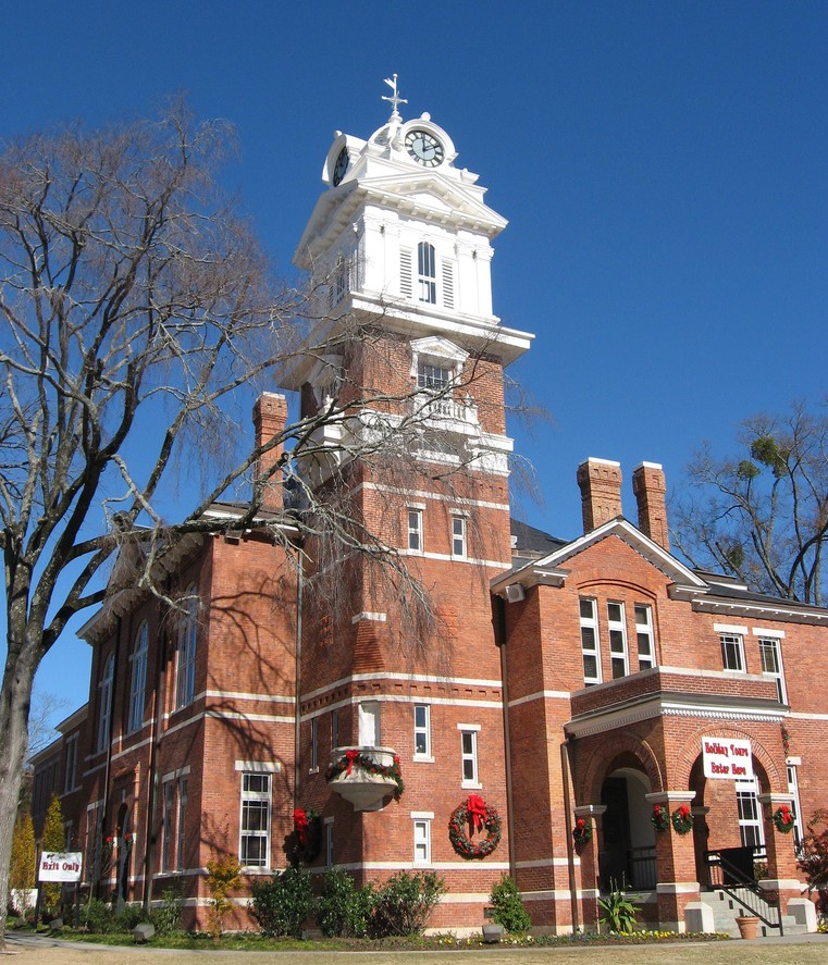


Lawrenceville, Georgia
Lawrenceville is a city of 30,954 people in Gwinnett County, Georgia, founded in 1821.
Why visit Lawrenceville
Townapedia lists 40 museums and landmarks, 9 parks and trails, 146 places to eat, 6 places to stay and 1 attraction in and around town.
Highlights include AMC Colonial 18, Gwinnett Historic Courthouse, Freeman's Mill and Gwinnett County Bicentennial Plaza.
Weather in Lawrenceville
Forecast from the National Weather Service. Full forecast
About Lawrenceville
Lawrenceville is a city in and the county seat of Gwinnett County, Georgia, United States. It is a suburb of Atlanta, located about 30 miles (50 km) northeast of downtown Atlanta. It was incorporated on December 15, 1821. As of the 2020 census, the population of Lawrenceville was 30,629.
From the Wikipedia article Lawrenceville, Georgia (this version), under CC BY-SA 4.0.
Things to do1

Museums and landmarks40

Gwinnett Historic Courthouse
Monument and historic site
Located on the square in historic downtown Lawrenceville, this renovated courthouse now accommodates private rentals and hosts special...
185 West Crogan Street, Lawrenceville
Mo 09:00-16:00; Tu 09:00-21:00; We 09:00-16:00; Th 09:00-21:00; Fr...

Freeman's Mill
Monument and historic site · National Register of Historic Places · 3.9 mi
Watermill in Gwinnett County, Georgia, United States
Gwinnett County Courthouse
Monument and historic site · National Register of Historic Places
County courthouse in Lawrenceville, United States of America
Old Seminary Building
Monument and historic site · National Register of Historic Places
Also known as The Old Masonic Lodge, in Lawrenceville, Georgia, NRHP-listed
William Terrell Homeplace
Monument and historic site · National Register of Historic Places · 1.8 mi
Plantation house in Gwinnett County, Georgia

Lawrenceville Female Seminary
Monument and historic site
455 South Perry Street, Lawrenceville
Mo-Sa 10:00-16:00

Expressions Gallery and Artist Studios
Museum · 0.6 mi
470 North Clayton Street, Lawrenceville
Independence of Texas from Mexico 1836 / Creek Indian War 1836
Monument and historic site
Lawrenceville Arts Center
Museum · 0.4 mi
125 North Clayton Street, Lawrenceville
28 more on the map.
Parks, trails and playgrounds9





Restaurants and cafes146


Chili's
Restaurant · Tex-Mex · 2.0 mi
947 Lawrenceville Suwanee Road
Su-Th 11:00-23:00; Fr-Sa 11:00-00:00
D'Floridian
Restaurant · Cuban
125 West Crogan Street, Lawrenceville
Su-Th 11:00-22:00; Fr-Sa 11:00-24:00
Foggy Bottom Barbeque
Restaurant · Barbecue
202 West Crogan Street, Lawrenceville
Tu-Th 11:00-21:00; Fr,Sa 11:00-22:00
Hooters
Restaurant · Burger · 1.8 mi
860 Duluth Highway
Mo-Th 11:00-00:00; Fr-Sa 11:00-01:00; Su 11:00-23:00
IHOP
Restaurant · Breakfast, Pancake · 3.3 mi
1143 Scenic Highway, Lawrenceville
Mo,Tu 06:00-22:00; We,Th 06:00-24:00; Fr,Sa 00:00-24:00; Su 00:00-22:00
LongHorn Steakhouse
Restaurant · Steak House · 2.1 mi
800 Lawrenceville Suwanee Road, Lawrenceville
Su-Th 11:00-22:00; Fr-Sa 11:00-23:00
McCray's Tavern
Restaurant · Burger, American
100 North Perry Street, Lawrenceville
Su-We 11:00-22:00; Th-Sa 11:00-23:00
Oyster Bay
Restaurant · Seafood
125 West Crogan Street, Lawrenceville
Su-Th 11:00-21:00; Fr,Sa 11:00-22:00
Starbucks
Cafe · Coffee Shop · 1.8 mi
860 Duluth Highway, Lawrenceville
Mo-Fr 05:00-21:30; Sa-Su 06:00-21:30

The Flying Machine
Diner · American · 2.1 mi
510 Brisco Boulevard, Lawrenceville
Tu-Th 11:00-21:00; Fr-Sa 11:00-22:00
134 more on the map.
History
Lawrenceville was incorporated by an act of the Georgia General Assembly on December 15, 1821. This makes Lawrenceville the second oldest city in the metropolitan Atlanta area. The city is named after Commodore James Lawrence, commander of the frigate Chesapeake during the War of 1812. Lawrence, a native of New Jersey, is probably best known today for his dying command, "Don't give up the ship!" William Maltbie, the town's first postmaster, suggested the name of "Lawrenceville."
In 1821, a permanent site for the county courthouse was selected and purchased, the four streets bordering the square were laid out along with other streets in the village, and a public well was dug. Major Grace built the first permanent courthouse, a brick structure, in 1823–24 for a cost of $4,000. The courthouse presently on the square was constructed in 1885.
During the tumultuous era of the Civil War, Gwinnett County stood as a notable exception, casting its vote against secession. At the heart of this dissent was Lawrenceville, the county seat, which dispatched three delegates to represent its staunch opposition to secession. This resistance stemmed partly from the county's unique demographic makeup, characterized by a relatively low slave population, where the ratio of whites to slaves stood at four to one.
From the History section of Lawrenceville, Georgia on Wikipedia, under CC BY-SA 4.0.
Where to stay6
Comfort Suites Northside Hospital Gwinnett
Motel and hotel · 2.7 mi
2225 Riverside Parkway, Lawrenceville
Holiday Inn Express & Suites Lawrenceville
Motel and hotel · 1.1 mi
520 John B Wilson Court, Lawrenceville
Churches and places of worship48
Emmanuel Church of South India
Church · Church Of South India · 2.3 mi
3521 Sugarloaf Parkway, Lawrenceville
First Baptist Church of Lawrenceville
Church · Baptist
165 South Clayton Street, Lawrenceville
First United Methodist Church of Lawrenceville
Church · Methodist
395 West Crogan Street, Lawrenceville
Tabernacle International Church
Church · 1.6 mi
270 Simonton Road Southwest, Lawrenceville
The Church of Jesus Christ of Latter-day Saints
Church · Mormon · 2.5 mi
3355 Sugarloaf Parkway, Lawrenceville
Shopping35
Gas and EV charging39
Schools, colleges and libraries51
Lawrenceville Hooper-Renwick Gwinnett County Public Library
Library · 0.5 mi
56 Neal Boulevard, Lawrenceville
Healthcare18
Eugene Medical Clinic
Clinic and pharmacy · 1.2 mi
248 East Crogan Street, Lawrenceville
Eastside Urgent Care
Clinic and pharmacy · 2.6 mi
3330 Sugarloaf Parkway, Lawrenceville
Gwinnett County Health Department
Clinic and pharmacy · 1.0 mi
455 Grayson Highway
Map of Lawrenceville
250 places. The map loads OpenStreetMap tiles when you open it.
People and cost of living
American Community Survey 5-year estimates, 2020-2024, U.S. Census Bureau. Estimates have margins of error, larger for small towns.
Disaster history
Gwinnett County has had 11 federal disaster declarations since 2000, most often for hurricanes.
- 2026-10-09: Hurricane Isaias (Tropical Storm)
- 2026-01-24: Severe Winter Storm (Winter Storm)
- 2024-09-26: Hurricane Helene (Tropical Storm)
- 2020-03-29: Covid-19 Pandemic (Biological)
- 2020-03-13: Covid-19 (Biological)
- 2017-09-15: Hurricane Irma (Hurricane)
OpenFEMA disaster declarations summaries.
Getting there and nearby towns
Gwinnett County Airport - Briscoe Field (LZU) is the nearest airport with scheduled flights listed in OpenStreetMap, 2 miles away.
- Grayson 5 mi southeast, about 8 min by car
- Dacula 6 mi east, about 9 min by car
- Snellville 6 mi south, about 10 min by car
- Suwanee 8 mi northwest, about 13 min by car
- Lilburn 9 mi southwest, about 15 min by car
- Duluth 10 mi west, about 16 min by car
- Sugar Hill 10 mi north, about 16 min by car
- Loganville 10 mi southeast, about 17 min by car
- Auburn 10 mi northeast, about 16 min by car
- Mountain Park 11 mi southwest, about 18 min by car
Drive times are estimates from straight-line distance, not routes.
Local news
Headlines from INDB, the NEMICO news database.
Reviews, tips and questions
Loading what members have shared...
Sources and licences
- NCES EDGE (Public domain): public schools
- OpenFEMA (Public domain): disaster declarations
- OpenStreetMap contributors (ODbL 1.0): places, airports, map data
- U.S. Census Bureau (Public domain): population, income, housing, education, commute
- Wikidata (CC0 1.0): elevation, founding date, time zone, website, landmarks and historic places
- Wikimedia Commons (see each image): photos
- Wikipedia (CC BY-SA 4.0): overview and history text
Photo credits
- Gwinnett County Courthouse GA, John Trainor, CC BY 2.0
- Old Female Seminary Building Marker - Lawrenceville, Georgia, Jcherepy, CC BY-SA 3.0
- Old Female Seminary Building - Lawrenceville, Georgia, Jcherepy, CC BY-SA 3.0
- Gwinnett County Goverment Annex Building Lawrenceville GA, Northwalker, CC0
- Major William Eleazar Simmons House in Lawrenceville GA during snowfall, Northwalker, CC0
- Kmart Lawrenceville, GA 4 (7722853896), Mike Kalasnik from Fort Mill, USA, CC BY-SA 2.0
- Kmart Lawrenceville, GA 3 (7722851900), Mike Kalasnik from Fort Mill, USA, CC BY-SA 2.0
- Kmart Lawrenceville, GA 2 (7722850022), Mike Kalasnik from Fort Mill, USA, CC BY-SA 2.0
- Kmart Lawrenceville, GA 1 (7722848402), Mike Kalasnik from Fort Mill, USA, CC BY-SA 2.0
- A&P Futurestore Lawrenceville, GA (7728433856), Mike Kalasnik from Fort Mill, USA, CC BY-SA 2.0
- A&P Futurestore Lawrenceville, GA (7728438600), Mike Kalasnik from Fort Mill, USA, CC BY-SA 2.0
- A&P Futurestore Lawrenceville, GA (7728436302), Mike Kalasnik from Fort Mill, USA, CC BY-SA 2.0
- Freeman’s Mill 04, MallardTV, CC0
- Gwinnett County Justice and Administrative Building, Unknown author, Public domain
- Isaac Adair House, Hedoesmusic, CC BY-SA 4.0
- City pays tribute to military children (5613646826), Georgia National Guard from United States, CC BY 2.0
- Button Gwinnette Marker, Markerman76, CC BY-SA 4.0
- Clarence R. Ware House, Jim Roberts, CC BY-SA 4.0
- Waffle House during Georgia Snow Storm, Northwalker, CC0
- 2016-07-31 16 01 03 Towering cumulus clouds over Gwinnett County, Georgia viewed from a plane traveling from Washington Dulles International Airport to Atlanta Hartsfield International Airport, Famartin, CC BY-SA 4.0
- Gwinnett County Airport from Hosea Road, Northwalker, CC0
- Pill Bug from GGC, MCRodila, CC BY-SA 4.0
- Crazy Ant, MCRodila, CC BY-SA 4.0
- Jindo at dog show, Jindodogs, CC BY-SA 4.0
- Cessna 150J N61123 at Gwinnett County Airport 2015-06-29 (18883989014), Pete Webber from SWINDON, United Kingdom, CC BY-SA 2.0
- N63515 (19318553950), Pete Webber from SWINDON, United Kingdom, CC BY-SA 2.0
- Psilocybe caerulescens.Atlanta, Evlyshroom, CC BY-SA 4.0
- Burned Receptacle, Karl Palutke, CC BY-SA 2.0
- ISS055-E-7430 - View of Tennessee, Earth Science and Remote Sensing Unit, NASA Johnson Space Center, Public domain
- Irma 2017-09-11 1630Z, National Aeronautics and Space Administration, LANCE/EOSDIS Rapid Response, captured on Terra satellite, Public domain
- ISS034-E-46599 - View of Earth, Earth Science and Remote Sensing Unit , Lyndon B. Johnson Space Center, Public domain
- ISS065-E-15469 - View of Earth, Earth Science and Remote Sensing Unit , Lyndon B. Johnson Space Center, Public domain


Page built October 30, 2026. Spotted a mistake? Tell us or suggest a place.