


Leavenworth, Washington
Leavenworth is a city of 2,569 people in Chelan County, Washington, founded in 1885.
Why visit Leavenworth
Townapedia lists 9 museums and landmarks, 17 parks and trails, 84 places to eat, 33 places to stay and 3 attractions in and around town.
Highlights include Leavenworth Ski Hill, Leavenworth Ranger Station, Nutcracker Museum & Store and Leavenworth Adventure Park.
July is the warmest month, with average highs of 87°F; January lows average 19°F, and about 80 inches of snow fall in a normal year.
Weather in Leavenworth
Forecast from the National Weather Service. Full forecast
About Leavenworth
Leavenworth is a city in Chelan County, Washington, United States. The population was 2,263 at the 2020 census. The entire town center is modeled on a Bavarian village as part of a civic initiative that began in the 1960s. Leavenworth is part of the Wenatchee–East Wenatchee metropolitan area.
From the Wikipedia article Leavenworth, Washington (this version), under CC BY-SA 4.0.
Things to do3
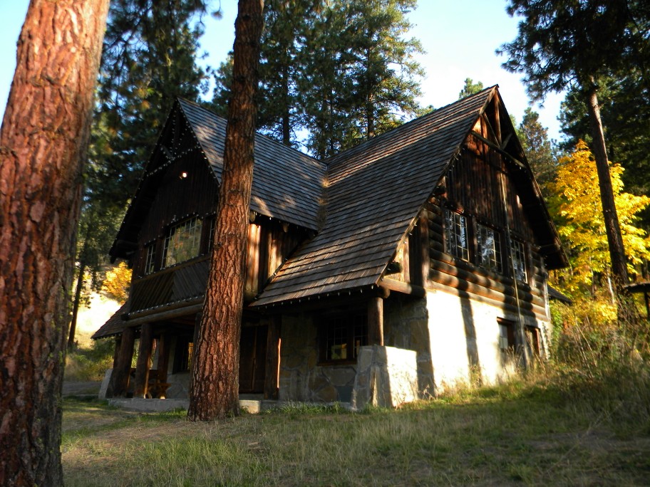
Leavenworth Ski Hill
Ski area · National Register of Historic Places · 1.4 mi
Ski resort in Chelan County, Washington

Museums and landmarks9


Leavenworth Ranger Station
Monument and historic site · National Register of Historic Places · 0.5 mi
Single-family detached home in Washington, United States of America


Leavenworth Reindeer Farm
Monument and historic site · 1.1 mi
10395 Chumstick Highway, Leavenworth
Parks, trails and playgrounds17

Leavenworth Adventure Park
Sports field and stadium · 0.8 mi
9342 Icicle Road, Leavenworth
10:00-20:00




5 more on the map.
Restaurants and cafes84


Leavenworth Pizza Company
Restaurant · Pizza
894 United States Highway 2, Leavenworth
Mo-Th 11:00-20:00; Fr-Su 09:00-20:00
Prusik Kitchen & Bar
Restaurant · Pizza, Regional, Pasta, Steak
219 9th Street, Leavenworth
Mo-Su 08:00-16:00
Wok About Grill
Restaurant · Mongolian Grill
920 Front Street, Leavenworth
Sa-Su 11:30-21:00; Mo-Th 16:00-20:00; Fr 16:00-21:00
Leavenworth Coffee and Waffles
Restaurant · Breakfast, Waffle, Coffee, Brunch, Lunch
894 United States Highway 2, Leavenworth
Mo-Su 07:00-12:45+


Starbucks
Cafe · Coffee Shop
932 Front Street, Leavenworth
PH,Mo-Su 05:30-20:00
72 more on the map.
History
The area near the confluence of Icicle Creek and the Wenatchee River in modern-day Leavenworth is within the traditional territories of the indigenous Wenatchi and Yakama peoples. The tribes had settlements on both waterways, including the villages of scəm̓ ̓áw̓s and sĭnpŭsqốĭsoḣ near modern-day Leavenworth, which was also a camas and root-gathering area. The Wenatchi and Yakama were signatories to the 1855 Treaty of Walla Walla; an Indian reservation for the Wenatchi covering 36 square miles (93 km2) around a fishery at the confluence was promised in the treaty but never surveyed by the federal government. Most members of the Wenatchi relocated to the Colville Indian Reservation and Yakama Indian Reservation in the early 20th century, while few remained in the Leavenworth and Cashmere area.
From the History section of Leavenworth, Washington on Wikipedia, under CC BY-SA 4.0.
Where to stay33
Churches and places of worship7
Community United Methodist Church
Church · Methodist
418 Evans Street, Leavenworth
Seventh Day Adventist Church
Church · Seventh Day Adventist · 1.2 mi
10600 Ski Hill Drive, Leavenworth
The Church of Jesus Christ of Latter-day Saints
Church · Mormon · 0.6 mi
10170 Titus Road, Leavenworth
Shopping47
Gas and EV charging6
Schools, colleges and libraries10
Healthcare1
Map of Leavenworth
217 places. The map loads OpenStreetMap tiles when you open it.
Climate by month
Monthly table
| Month | High | Low | Rain | Snow |
|---|---|---|---|---|
| Jan | 34°F | 19°F | 4.1 in | 22.1 in |
| Feb | 42°F | 21°F | 2.9 in | 12.6 in |
| Mar | 52°F | 26°F | 2.5 in | 4.7 in |
| Apr | 61°F | 32°F | 1.2 in | 0.0 in |
| May | 71°F | 40°F | 1.4 in | 0.0 in |
| Jun | 77°F | 46°F | 1.0 in | 0.0 in |
| Jul | 87°F | 51°F | 0.5 in | 0.0 in |
| Aug | 87°F | 50°F | 0.4 in | 0.0 in |
| Sep | 78°F | 42°F | 0.8 in | 0.0 in |
| Oct | 62°F | 33°F | 2.4 in | 0.3 in |
| Nov | 44°F | 26°F | 4.1 in | 8.1 in |
| Dec | 34°F | 20°F | 4.5 in | 32.4 in |
U.S. Climate Normals 1991-2020 for Leavenworth 3 S (3 mi away), NOAA NCEI.
People and cost of living
American Community Survey 5-year estimates, 2020-2024, U.S. Census Bureau. Estimates have margins of error, larger for small towns.
Disaster history
Chelan County has had 47 federal disaster declarations since 2000, most often for fires.
- 2026-08-03: Wildfires (Fire)
- 2026-04-07: Severe Storms, Straight-Line Winds, Flooding, Landslides, And Mudslides (Flood)
- 2025-12-12: Severe Storms, Straight-Line Winds, Flooding, Landslides, And Mudslides (Flood)
- 2025-09-26: Lower Sugarloaf Fire (Fire)
- 2022-03-29: Severe Winter Storms, Snowstorms, Straight-Line Winds, Flooding (Flood)
- 2021-08-18: Twentyfive Mile Fire (Fire)
OpenFEMA disaster declarations summaries.
Getting there and nearby towns
Pangborn Memorial Airport (EAT) is the nearest airport with scheduled flights listed in OpenStreetMap, 25 miles away.
- Cashmere 11 mi southeast, about 17 min by car
- Wenatchee 19 mi southeast, about 31 min by car
- Entiat 21 mi east, about 34 min by car
- East Wenatchee 22 mi southeast, about 35 min by car
- Cle Elum 31 mi southwest, about 49 min by car
- Chelan 35 mi northeast, about 56 min by car
- Ellensburg 41 mi south, about 1 h by car
- Kittitas 44 mi south, about 1 h 15 min by car
- Gold Bar 51 mi west, about 1 h 15 min by car
- Bridgeport 54 mi northeast, about 1 h 30 min by car
Drive times are estimates from straight-line distance, not routes.
Local news
Headlines from INDB, the NEMICO news database.
Reviews, tips and questions
Loading what members have shared...
Sources and licences
- NCES EDGE (Public domain): public schools
- NOAA NCEI U.S. Climate Normals 1991-2020 (Public domain): climate by month
- OpenFEMA (Public domain): disaster declarations
- OpenStreetMap contributors (ODbL 1.0): places, airports, map data
- U.S. Census Bureau (Public domain): population, income, housing, education, commute
- Wikidata (CC0 1.0): elevation, founding date, time zone, website, landmarks and historic places
- Wikimedia Commons (see each image): photos
- Wikipedia (CC BY-SA 4.0): overview and history text
Photo credits
- Main street in Leavenworth, Washington (2023-06-18) (cropped), Roc0ast3r, CC0
- Leavenworth City Hall, Steven Pavlov User:Senapa/TemplateFB, CC BY-SA 3.0
- Bavarian Ritz Hotel (Leavenworth, WA), Steven Pavlov User:Senapa/TemplateFB, CC BY-SA 3.0
- Front St. Leavenworth, WA, Steven Pavlov User:Senapa/TemplateFB, CC BY-SA 3.0
- Leavenworth, WA — Victorian Simplicity, senapa, CC BY-SA 3.0
- Leavenworth, WA — Front Street — 02, senapa, CC BY-SA 3.0
- Leavenworth, WA — Glockenspiel Mall, senapa, CC BY-SA 3.0
- Leavenworth, WA — Wood Shop & Hat Shop, senapa, CC BY-SA 3.0
- Leavenworth, WA — Front Street, senapa, CC BY-SA 3.0
- Front St. Leavenworth, WA at night (panorama), Steven Pavlov, CC BY-SA 3.0
- Front St. Leavenworth, WA (panorama), Steven Pavlov, CC BY-SA 3.0
- Wenatchee River at Blackbird Island Leavenworth Washington 4, Thayne Tuason, CC BY-SA 4.0
- Ribes aureum sprouting new leaves in spring on Wenatchee River Leavenworth, Thayne Tuason, CC BY-SA 4.0
- Leavenworth, WA , USA - panoramio (2), tamara semina, CC BY-SA 3.0
- Leavenworth, WA , USA - panoramio (1), tamara semina, CC BY-SA 3.0
- Street scene, Leavenworth, WA. (1769483043), Robert Ashworth from Bellingham, WA., USA, CC BY 2.0
- Wenatchee River and Pedestrian Bridge to Blackbird Island Leavenworth Washington, Thayne Tuason, CC BY-SA 4.0
- Blackbird Island Bridge Leavenworth, Thayne Tuason, CC BY-SA 4.0
- Wenatchee River, Riverfront Park, Leavenworth, WA, Steven Pavlov, CC BY-SA 3.0
- Leavenworth, WA — Hotel Europa, senapa, CC BY-SA 3.0
- Leavenworth, WA , USA - panoramio, tamara semina, CC BY-SA 3.0
- Main street in Leavenworth, Washington (2023-06-18), Roc0ast3r, CC0
- Leavenworth, WA — Hotel Edelweiss, senapa, CC BY-SA 3.0
- Leavenworth, WA — Kris Kringle Store, senapa, CC BY-SA 3.0
- Leavenworth, WA — Obertal Mall and Inn, senapa, CC BY-SA 3.0
- Brent, Loge Hotel, Leavenworth, Washington (52302278963), lamblukas from San Francisco, United States, CC BY 2.0
- Wenatchee River at Blackbird Island Leavenworth Washington 2, Thayne Tuason, CC BY-SA 4.0
- Animal tracks at Wenatchee River at Blackbird Island Leavenworth Washington 1, Thayne Tuason, CC BY-SA 4.0
- Scene at the Bavarian Celebration of Spring festival in Leavenworth, Washington (LOC) (54562971606), The Library of Congress, No restrictions
- Leavenworth, WA — Formerly St. Joseph Catholic Church, Steven Pavlov, CC BY-SA 3.0
- Leavenworth, WA — Formerly St. Joseph Catholic Church (PNG), Steven Pavlov, CC BY-SA 3.0
- Leavenworth Ski Hill Historic District, Jon Roanhaus, CC BY-SA 3.0
- Leavenworth Ranger Station, J. Thomas Wilson, Public domain
- Euonymus alatus - Day 282 of 366 (30783489881), Gallant's Photography, CC BY 2.0
- Lighting Weekend Dec - panoramio, Mr.B, CC BY 3.0
- Christmas Tree Lighting Weekend Dec 2010- Daytime Fun - panoramio, Mr.B, CC BY 3.0
- YAHOO-CHRISTMAS TREE LIGHTING WEEKEND-2010-Kid's Sleding Hill - panoramio, Mr.B, CC BY 3.0
- Christmas Tree Lighting Weekend Dec 2010-Fireworks Tree - panoramio, Mr.B, CC BY 3.0
- Yellow and green (Unsplash), Collie Coburn colliesr, CC0
- Фанаты после концерта в Америке (группа BOSÁYA), Galina Bosaya, CC BY-SA 4.0


Page built October 30, 2026. Spotted a mistake? Tell us or suggest a place.