

Leon Valley, Texas
Leon Valley is a city of 11,446 people in Bexar County, Texas, founded in 1952.
Why visit Leon Valley
Townapedia lists 4 museums and landmarks, 16 parks and trails, 90 places to eat, 7 places to stay and 3 attractions in and around town.
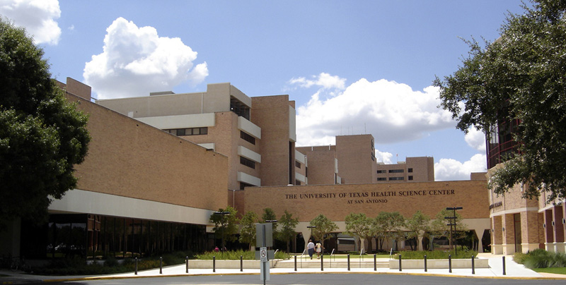
Highlights include San Antonio Aquarium, University of Texas Health Science Center at San Antonio, Denman Estate Park and Huebner-Onion Natural Area Park.
Weather in Leon Valley
Forecast from the National Weather Service. Full forecast
About Leon Valley
Leon Valley is a city in Bexar County, Texas, United States. It is an enclave on the northwestern side of San Antonio and is part of the San Antonio-New Braunfels metropolitan statistical area. Its population was 11,542 at the 2020 census. Leon Valley is an independent municipality surrounded by the city of San Antonio.
From the Wikipedia article Leon Valley, Texas (this version), under CC BY-SA 4.0.
Things to do3

San Antonio Aquarium
Monument and historic site · 0.6 mi
Zoo in San Antonio, Texas
University of Texas Health Science Center at San Antonio
School · 2.4 mi
Hospital in Texas, United States

Museums and landmarks4
Parks, trails and playgrounds16


Denman Estate Park
Park · 3.4 mi
Park in Texas, United States of America


French Creek Greenway Mainland Drive Trailhead
Park · 2.0 mi
7787 Mainland Drive, San Antonio

4 more on the map.
Restaurants and cafes90


Hacienda Vallarta Mexican Buffet & Bakery
Restaurant · Mexican · 1.1 mi
7200 Bandera Road, Leon Valley
Mo-Th 10:30-21:00, Fr-Sa 10:30-22:00, Su 09:00-21:00
The Rodeo Bar And Grill
Restaurant · Mexican · 1.1 mi
7247 Bandera Road, San Antonio
Mo-Su 06:00-23:00

Dutch Bros. Coffee
Cafe · Coffee Shop · 1.7 mi
7962 Bandera Road, San Antonio
Mo-Th 05:00-22:00; Fr-Sa 05:00-23:00; Su 05:00-22:00
Dutch Bros. Coffee
Cafe · Coffee Shop · 1.9 mi
8658 Huebner Road, San Antonio
Mo-Th 05:00-22:00; Fr-Sa 05:00-23:00; Su 05:00-22:00
El Viejo 300
Restaurant · Mexican · 1.8 mi
7271 Wurzbach Road, San Antonio
12:00-21:00
78 more on the map.
History
Leon Valley was developed in the 1940s as a farming community on Bandera Road between Helotes and San Antonio. In 1952, residents filed a petition[1] for incorporation as an independent city, since the residents did not wish to be annexed by San Antonio. Leon Valley incorporated in 1954 under the leadership of its founding mayor, Raymond Rimkus. In 1960, it had a population of 536 and by 1970, its population grew to 1,960. In 1990, it had 9,581 people.
From the History section of Leon Valley, Texas on Wikipedia, under CC BY-SA 4.0.
Where to stay7
Churches and places of worship32
Church of God Mission San Antonio
Church · Protestant · 1.5 mi
6914 King George Drive, San Antonio
Saint Andrews Episcopal Church
Church · Anglican · 1.7 mi
6110 Northwest Loop 410, San Antonio
Shopping15
Gas and EV charging12
Schools, colleges and libraries59
Basis San Antonio - Jack Lewis Jr Campus
School · 5.7 mi
3303 N Ellison Dr, San Antonio
Healthcare11
HealthTexas - Leon Valley
Clinic and pharmacy · 0.4 mi
6428 Bandera Road, San Antonio
Hopscotch Health Children's Urgent Care
Clinic and pharmacy · 0.9 mi
7108 Bandera Road, Leon Valley
Passport Health San Antonio Travel Clinic
Clinic and pharmacy · 1.8 mi
4242 Medical Drive, San Antonio
Pinnacle Clinical Research
Clinic and pharmacy · 2.0 mi
5109 Medical Drive, San Antonio
Map of Leon Valley
249 places. The map loads OpenStreetMap tiles when you open it.
People and cost of living
American Community Survey 5-year estimates, 2020-2024, U.S. Census Bureau. Estimates have margins of error, larger for small towns.
Disaster history
Bexar County has had 24 federal disaster declarations since 2000, most often for hurricanes.
- 2026-07-18: Flooding (Flood)
- 2025-03-05: Duke Fire (Fire)
- 2021-02-19: Severe Winter Storms (Severe Ice Storm)
- 2021-02-14: Severe Winter Storm (Severe Ice Storm)
- 2020-08-24: Tropical Storms Marco And Laura (Hurricane)
- 2020-07-26: Hurricane Hanna (Hurricane)
OpenFEMA disaster declarations summaries.
Getting there and nearby towns
Kelly Field (SKF) is the nearest airport with scheduled flights listed in OpenStreetMap, 8 miles away.
- San Antonio 6 mi southeast, about 10 min by car
- Fair Oaks Ranch 17 mi north, about 28 min by car
- Converse 19 mi east, about 30 min by car
- Boerne 21 mi north, about 34 min by car
- Cibolo 25 mi east, about 40 min by car
- New Braunfels 33 mi northeast, about 53 min by car
- Canyon Lake 34 mi northeast, about 54 min by car
- Kerrville 49 mi northwest, about 1 h 15 min by car
- Fredericksburg 55 mi north, about 1 h 30 min by car
- Kyle 56 mi northeast, about 1 h 30 min by car
Drive times are estimates from straight-line distance, not routes.
Local news
Headlines from INDB, the NEMICO news database.
Reviews, tips and questions
Loading what members have shared...
Sources and licences
- NCES EDGE (Public domain): public schools
- OpenFEMA (Public domain): disaster declarations
- OpenStreetMap contributors (ODbL 1.0): places, airports, map data
- U.S. Census Bureau (Public domain): population, income, housing, education, commute
- Wikidata (CC0 1.0): elevation, founding date, time zone, website, landmarks and historic places
- Wikimedia Commons (see each image): photos
- Wikipedia (CC BY-SA 4.0): overview and history text
Photo credits
- UTHSCSAmain, Zereshk, CC BY 2.5
- Gwangju San Antonio2, Nightryder84, CC BY-SA 3.0
Page built October 30, 2026. Spotted a mistake? Tell us or suggest a place.