


Why visit Livingston
Townapedia lists 1 museum or landmark, 5 parks and trails, 9 places to eat, 3 places to stay and 4 attractions in and around town.
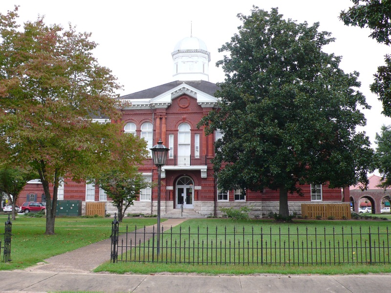
Highlights include Alamuchee-Bellamy Covered Bridge, University of West Alabama and Sumter County Courthouse.
August is the warmest month, with average highs of 92°F; January lows average 34°F.
Weather in Livingston
Forecast from the National Weather Service. Full forecast
About Livingston
Livingston is a city in and the county seat of Sumter County, Alabama, United States and the home of the University of West Alabama. By an act of the state legislature, it was incorporated on January 10, 1835. As of the 2020 census, Livingston had a population of 3,436. It was named in honor of Edward Livingston, of the Livingston family of New York.
From the Wikipedia article Livingston, Alabama (this version), under CC BY-SA 4.0.
Things to do4
Alamuchee-Bellamy Covered Bridge
Bridge
Bridge in Livingston, Alabama

University of West Alabama
School · 0.4 mi
Public university in Livingston, Alabama, United States


Museums and landmarks1

Sumter County Courthouse
Monument and historic site · National Register of Historic Places · 0.9 mi
Courthouse in Livingston (Alabama)
Parks, trails and playgrounds5

Restaurants and cafes9



McDonald's
Fast food · Burger · 2.3 mi
704 AL 28, Livingston
Mo-We 06:00-23:00; Th 06:00-24:00; Fr-Sa 00:00-24:00
History
The area now known as Livingston was part of the traditional territory of the nation of Choctaw Indians until the Treaty of Dancing Rabbit Creek in 1830. The federal government removed most of the Choctaw to Indian Territory in present-day Oklahoma. At that time, settlers from the Carolinas, Georgia, Tennessee, and Virginia established the first European-American community about two blocks from the current Courthouse Square, near the corner of Madison and Spring Streets.
In 1833, a commission was formed to organize Sumter County. Livingston was named after a well-known statesman and jurist of the day, Edward Livingston. Livingston was chosen as the county seat. Soon followed the first newspaper, The Voice of Sumter; four schools (including Livingston Female Academy, now The University of West Alabama), the courthouse, and the Bored Well.
The first courthouse was built of logs. It was replaced by a frame courthouse in 1839, which burned in 1901. The Probate Judge's office, built at the same time, survived the fire. It now houses the county commission office.
From the History section of Livingston, Alabama on Wikipedia, under CC BY-SA 4.0.
Where to stay3
Churches and places of worship8
Shopping2
Gas and EV charging3
Schools, colleges and libraries10
University Charter School Elementary
School · 0.7 mi
108 North Street, Livingston
University Charter School Secondary
School · 0.4 mi
134 University Drive, Livingston
Map of Livingston
45 places. The map loads OpenStreetMap tiles when you open it.
Climate by month
Monthly table
| Month | High | Low | Rain | Snow |
|---|---|---|---|---|
| Jan | 57°F | 34°F | 5.3 in | 0.0 in |
| Feb | 63°F | 36°F | 5.7 in | 0.0 in |
| Mar | 70°F | 43°F | 5.5 in | 0.0 in |
| Apr | 77°F | 50°F | 5.2 in | 0.0 in |
| May | 84°F | 59°F | 3.8 in | 0.0 in |
| Jun | 89°F | 68°F | 4.3 in | 0.0 in |
| Jul | 92°F | 70°F | 4.8 in | 0.0 in |
| Aug | 92°F | 70°F | 4.3 in | 0.0 in |
| Sep | 87°F | 64°F | 3.3 in | 0.0 in |
| Oct | 78°F | 52°F | 3.5 in | 0.0 in |
| Nov | 67°F | 40°F | 4.2 in | 0.0 in |
| Dec | 59°F | 35°F | 5.1 in | 0.0 in |
U.S. Climate Normals 1991-2020 for Livingston (1 mi away), rain and snow from Gainesville Lock Hcn, NOAA NCEI.
People and cost of living
American Community Survey 5-year estimates, 2020-2024, U.S. Census Bureau. Estimates have margins of error, larger for small towns.
Disaster history
Sumter County has had 15 federal disaster declarations since 2000, most often for hurricanes.
- 2024-09-26: Hurricane Helene (Hurricane)
- 2023-01-15: Severe Storms, Straight-Line Winds, And Tornadoes (Severe Storm)
- 2020-09-14: Hurricane Sally (Hurricane)
- 2020-03-29: Covid-19 Pandemic (Biological)
- 2020-03-13: Covid-19 (Biological)
- 2017-10-08: Hurricane Nate (Hurricane)
OpenFEMA disaster declarations summaries.
Getting there and nearby towns
George Downer Airport (AIV) is the nearest airport with scheduled flights listed in OpenStreetMap, 35 miles away.
- Demopolis 22 mi east, about 35 min by car
- Eutaw 24 mi northeast, about 39 min by car
- Marion 29 mi southwest, about 47 min by car
- Meridian 33 mi southwest, about 53 min by car
- Butler 35 mi south, about 56 min by car
- Greensboro 35 mi east, about 57 min by car
- Aliceville 37 mi north, about 59 min by car
- Nellieburg 37 mi west, about 1 h by car
- Macon 42 mi northwest, about 1 h 15 min by car
- Moundville 43 mi northeast, about 1 h 15 min by car
Drive times are estimates from straight-line distance, not routes.
Local news
Headlines from INDB, the NEMICO news database.
Reviews, tips and questions
Loading what members have shared...
Sources and licences
- NCES EDGE (Public domain): public schools
- NOAA NCEI U.S. Climate Normals 1991-2020 (Public domain): climate by month
- OpenFEMA (Public domain): disaster declarations
- OpenStreetMap contributors (ODbL 1.0): places, airports, map data
- U.S. Census Bureau (Public domain): population, income, housing, education, commute
- Wikidata (CC0 1.0): elevation, founding date, time zone, website, landmarks and historic places
- Wikimedia Commons (see each image): photos
- Wikipedia (CC BY-SA 4.0): overview and history text
Photo credits
- SumterCountyAlabamaCourthouseLivingstonAlabama, DwayneP, CC BY-SA 3.0
- AlamucheeCB, Mld74 at English Wikipedia, Public domain
Page built October 30, 2026. Spotted a mistake? Tell us or suggest a place.