




Why visit London
Townapedia lists 4 museums and landmarks, 6 parks and trails, 50 places to eat, 9 places to stay and 3 attractions in and around town.
Highlights include Regency Cinema, Federal Building-Courthouse, Poynter Building and Levi Jackson Wilderness Road State Park.
July is the warmest month, with average highs of 86°F; January lows average 27°F.
Weather in London
Forecast from the National Weather Service. Full forecast
About London
London is a home rule-class city in and the county seat of Laurel County, Kentucky, United States. As of the 2020 census, its population was 8,053. London is home to the annual World Chicken Festival that celebrates the life of Colonel Sanders and features the world's largest skillet.
From the Wikipedia article London, Kentucky (this version), under CC BY-SA 4.0.
Things to do3


Museums and landmarks4
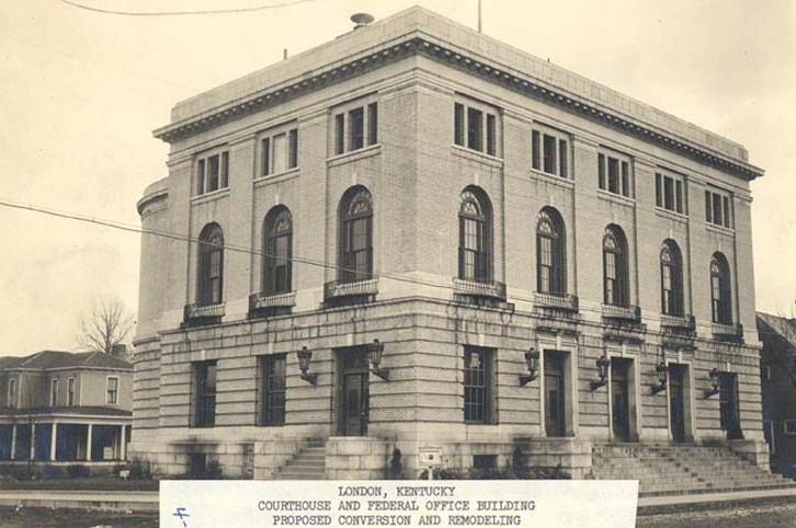
Federal Building-Courthouse
Monument and historic site · National Register of Historic Places · 0.7 mi
Courthouse in London, Kentucky, United States

Poynter Building
Monument and historic site · National Register of Historic Places · 0.8 mi


Parks, trails and playgrounds6


Levi Jackson Wilderness Road State Park
Park · 3.2 mi
State park in Kentucky, United States


Restaurants and cafes50


Mi Casa #2
Restaurant · Mexican · 1.0 mi
1740 HWY 192 W, London
Mo-Th 11:00-22:00, Fr - Sa 11:00-22:30, Su 11:00-21:00


38 more on the map.
History
The area around London had been territory of the Cherokee people for centuries. In 1776, Daniel Boone passed through the area that would become London.
Upon the establishment of Laurel County in 1825, a vote was held to provide for the new area's seat of government. The land offered by John Jackson and his son Jarvis Jackson was selected, along with their suggested name of London, honoring their English heritage.
The town was founded the next year, its post office established in 1831, and its city rights granted in 1836.
One of John Jackson's sons was Hancock Lee Jackson, 13th governor of Missouri. His second cousin was Claiborne Fox Jackson, 15th governor of Missouri.
In 1861, the Battle of Camp Wildcat was fought early in the American Civil War to the north of the town.
In 1865, the non-denominational, First Christian Church of London was founded.
The St. Joseph's Hospital, which at the time was known as the Pennington General Hospital, was founded on April 20, 1926.
During the Depression of the late 1930s and early 1940s, the Works Progress Administration of President Franklin D. Roosevelt established the Pack Horse Library Project to serve rural people in the mountains. London served as a central collection agency for books donated to his program. It also had a pack horse library, whose riders delivered books to rural residents.
From the History section of London, Kentucky on Wikipedia, under CC BY-SA 4.0.
Where to stay9
Budget Host Westgate Inn Motel and Westgate RV Campground
Motel and hotel · 3.0 mi
254 Russell Dyche Memorial Highway, London
Churches and places of worship11
Shopping9
Gas and EV charging9
Schools, colleges and libraries19
East Bernstadt Elementary School
School · 5.3 mi
229 School Street, East Bernstadt
Laurel Co Schools Center For Innovation
School · 1.1 mi
1100 East Fourth Street, London
Laurel County Schools Elearning Academy
School · 1.1 mi
718 N. Main Street, London
Healthcare5
Map of London
125 places. The map loads OpenStreetMap tiles when you open it.
Climate by month
Monthly table
| Month | High | Low | Rain |
|---|---|---|---|
| Jan | 45°F | 27°F | 3.9 in |
| Feb | 50°F | 30°F | 4.0 in |
| Mar | 58°F | 36°F | 4.6 in |
| Apr | 69°F | 45°F | 4.7 in |
| May | 77°F | 54°F | 5.0 in |
| Jun | 84°F | 62°F | 5.1 in |
| Jul | 86°F | 66°F | 5.2 in |
| Aug | 86°F | 65°F | 4.0 in |
| Sep | 80°F | 58°F | 3.5 in |
| Oct | 70°F | 45°F | 3.3 in |
| Nov | 58°F | 36°F | 3.5 in |
| Dec | 48°F | 30°F | 4.5 in |
U.S. Climate Normals 1991-2020 for London Corbin Ap 72329 (2 mi away), NOAA NCEI.
People and cost of living
American Community Survey 5-year estimates, 2020-2024, U.S. Census Bureau. Estimates have margins of error, larger for small towns.
Disaster history
Laurel County has had 20 federal disaster declarations since 2000, most often for severe storms.
- 2026-05-29: Severe Winter Storm (Winter Storm)
- 2026-01-24: Severe Winter Storm (Winter Storm)
- 2025-05-23: Severe Storms, Straight-Line Winds, And Tornadoes (Severe Storm)
- 2025-04-03: Severe Storms, Straight-Line Winds, Tornadoes, And Flooding (Severe Storm)
- 2025-02-24: Severe Storms, Straight-Line Winds, Flooding, Landslides, And Mudslides (Severe Storm)
- 2025-02-16: Severe Storms, Straight-Line Winds, Flooding, And Landslides (Severe Storm)
OpenFEMA disaster declarations summaries.
Getting there and nearby towns
London-Corbin Airport (LOZ) is the nearest airport with scheduled flights listed in OpenStreetMap, 2 miles away.
- Corbin 13 mi south, about 21 min by car
- Manchester 17 mi east, about 28 min by car
- Barbourville 21 mi southeast, about 33 min by car
- Brodhead 27 mi northwest, about 43 min by car
- Somerset 29 mi west, about 47 min by car
- Berea 35 mi north, about 56 min by car
- Beattyville 38 mi northeast, about 1 h by car
- Irvine 40 mi north, about 1 h by car
- Richmond 44 mi north, about 1 h 15 min by car
- Lancaster 44 mi northwest, about 1 h 15 min by car
Drive times are estimates from straight-line distance, not routes.
Local news
Headlines from INDB, the NEMICO news database.
Reviews, tips and questions
Loading what members have shared...
Sources and licences
- NCES EDGE (Public domain): public schools
- NOAA NCEI U.S. Climate Normals 1991-2020 (Public domain): climate by month
- OpenFEMA (Public domain): disaster declarations
- OpenStreetMap contributors (ODbL 1.0): places, airports, map data
- U.S. Census Bureau (Public domain): population, income, housing, education, commute
- Wikidata (CC0 1.0): elevation, founding date, time zone, website, landmarks and historic places
- Wikimedia Commons (see each image): photos
- Wikipedia (CC BY-SA 4.0): overview and history text
Photo credits
- Downtown London KY, w.marsh, CC BY 2.0
- London KY Banner, w.marsh, CC BY 2.0
- Federal Building-Courthouse, London (Laurel County, Kentucky), Unknown - Federal Judiciary Center, Public domain
- Poynter Building, Nyttend, Public domain
- McHargue’s Mill, J654567, CC BY-SA 3.0
- Laurel County Judicial Center, Nyttend, Public domain
- Rand Paul (4469688044), Gage Skidmore from Surprise, AZ, United States of America, CC BY-SA 2.0
- Rand Paul (4468941971), Gage Skidmore from Surprise, AZ, United States of America, CC BY-SA 2.0
- Rand Paul (4468912829), Gage Skidmore from Surprise, AZ, United States of America, CC BY-SA 2.0
- Rand Paul (4468931193), Gage Skidmore from Surprise, AZ, United States of America, CC BY-SA 2.0
- Rand Paul (4468935339), Gage Skidmore from Surprise, AZ, United States of America, CC BY-SA 2.0
- Rand Paul supporter (4468939149), Gage Skidmore from Surprise, AZ, United States of America, CC BY-SA 2.0
- Don't Tread on Me (4468957051), Gage Skidmore from Surprise, AZ, United States of America, CC BY-SA 2.0
- Rand Paul (4469733528), Gage Skidmore from Surprise, AZ, United States of America, CC BY-SA 2.0
- Rand Paul (4469725898), Gage Skidmore from Surprise, AZ, United States of America, CC BY-SA 2.0
- Rand Paul bumper sticker (4469729172), Gage Skidmore from Surprise, AZ, United States of America, CC BY-SA 2.0
- Rand Paul (4469668636), Gage Skidmore from Surprise, AZ, United States of America, CC BY-SA 2.0
- Rand Paul (4468923483), Gage Skidmore from Surprise, AZ, United States of America, CC BY-SA 2.0
- Rand Paul (4468875459), Gage Skidmore from Surprise, AZ, United States of America, CC BY-SA 2.0
- Rand Paul (4468915485), Gage Skidmore from Surprise, AZ, United States of America, CC BY-SA 2.0
- Rand Paul (4469671694), Gage Skidmore from Surprise, AZ, United States of America, CC BY-SA 2.0
- Rand Paul (4468927065), Gage Skidmore from Surprise, AZ, United States of America, CC BY-SA 2.0
- Rand Paul (4469698164), Gage Skidmore from Surprise, AZ, United States of America, CC BY-SA 2.0
- Rand Paul (4468897119), Gage Skidmore from Surprise, AZ, United States of America, CC BY-SA 2.0
- Sue Bennett Memorial School, Nyttend, Public domain
- Laurel County Courthouse, Nyttend, Public domain


Page built October 30, 2026. Spotted a mistake? Tell us or suggest a place.