
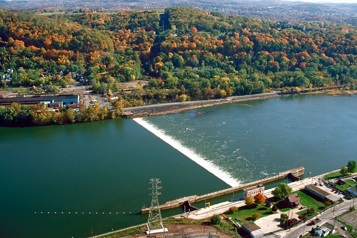


Lower Burrell, Pennsylvania
Lower Burrell is a city of 11,633 people in Westmoreland County, Pennsylvania, founded in 1852.
Why visit Lower Burrell
Townapedia lists 26 museums and landmarks, 19 parks and trails, 43 places to eat, 1 place to stay and 2 attractions in and around town.
Highlights include C. L. Schmitt Bridge, George D. Stuart Bridge, Allegheny River Lock and Dam No. 4 and Burtner House.
July is the warmest month, with average highs of 83°F; January lows average 20°F.
Weather in Lower Burrell
Forecast from the National Weather Service. Full forecast
About Lower Burrell
Lower Burrell is a city in northern Westmoreland County, Pennsylvania, United States, along the Allegheny River. Located approximately 18 miles northeast of downtown Pittsburgh, it is part of the Pittsburgh metropolitan area. The population was 11,758 at the 2020 census.
From the Wikipedia article Lower Burrell, Pennsylvania (this version), under CC BY-SA 4.0.
Things to do2

C. L. Schmitt Bridge
Bridge · 3.1 mi
Bridge in Pennsylvania, United States


George D. Stuart Bridge
Bridge · 2.2 mi
Bridge over the Allegheny River in Pennsylvania
Museums and landmarks26

Allegheny River Lock and Dam No. 4
Monument and historic site · National Register of Historic Places · 2.2 mi
Gravity dam and lock in Harrison Township, Pennsylvania
Burtner House
Monument and historic site · National Register of Historic Places · 3.4 mi
Historic house in Pennsylvania, United States
Byerly House
Monument and historic site · National Register of Historic Places · 2.7 mi
Historic house in Pennsylvania, United States
Logans Ferry Powder Works Historic District
Monument and historic site · National Register of Historic Places · 4.0 mi
Historic district in Pennsylvania, United States
New Kensington Downtown Historic District
Monument and historic site · National Register of Historic Places · 2.8 mi
Historic district in New Kensington, Pennsylvania
New Kensington Production Works Historic District
Monument and historic site · National Register of Historic Places · 3.0 mi
Historic district in Pennsylvania, United States
Pennsalt Historic District
Monument and historic site · National Register of Historic Places · 2.2 mi
Historic district in Pennsylvania, United States
Rachel Carson Homestead
Monument and historic site · National Register of Historic Places · 4.3 mi
Birthplace of Rachel Carson

Esplanade
Monument and historic site · 2.1 mi
The esplanade consists of concrete-paved fill between the former river bank and the lock's land wall.
Lock No. 4
Monument and historic site · 2.1 mi
The lock, 56 by 360 feet, has a lift of 10.6 feet, from 734.8 to 745.4 feet. The sidewalls are steel-armored concrete, and mooring pins...
14 more on the map.
Parks, trails and playgrounds19

Fireman's Memorial Park
Park · 2.9 mi
Has a few gazebos as well as signs detailing the history of Arnold.


7 more on the map.
Restaurants and cafes43


Phillippi's
Restaurant · American, Pizza · 3.0 mi
2105 Freeport Road, Natrona Heights
Mo-Sa 08:00-02:00; Su 09:00-02:00
Villa Ballanca
Restaurant · Italian · 1.0 mi
2740 Leechburg Road, Lower Burrell
We-Sa 11:00-21:00; Su 11:00-20:00

Steel Cup Coffee Roasters
Cafe · Coffee Shop · 2.7 mi
507 10th Street, New Kensington
Mo-Sa 08:00-15:00
Maddio's Pizza and Subs
Restaurant · Pizza, Sandwich · 2.5 mi
1000 Broadview Boulevard, Brackenridge
Mo-We 11:00-21:00, Th-Sa 11:00-23:00; Su 12:00-21:00
3740 Cafe
Cafe · Coffee Shop · 2.7 mi
3740 Milligantown Road, New Kensington
Mo-Fr 06:00-20:00, Sa 08:00-20:00, Su 08:00-14:00
Taqueria el Pastorcito
Restaurant · Mexican · 2.8 mi
929 4th Avenue, New Kensington
31 more on the map.
History
The region in which Lower Burrell is located was originally part of the hunting reserves of the Iroquois. Permanent European settlement began in the 1760s, and Westmoreland County was created in 1773. In 1852, due to an increase in population in the area, Burrell Township was carved out of Allegheny Township on court order of Judge Jeremiah Murry Burrell. In 1879 Burrell Township was divided into two separate townships, Lower Burrell and Upper Burrell. The present-day cities of New Kensington and Arnold were once part of Lower Burrell Township. In the years that followed, Lower Burrell transformed from a quiet, rural farm community to a residential and commercial area while Upper Burrell stayed primarily rural. Upper Burrell Township is still somewhat rural, though it has experienced some suburban growth and sprawl in recent years.
From the History section of Lower Burrell, Pennsylvania on Wikipedia, under CC BY-SA 4.0.
Where to stay1
Churches and places of worship54
Mount Saint Peter Church
Church · Roman Catholic · 2.6 mi
100 Freeport Road, New Kensington
Mount St. Peter Church
Church · National Register of Historic Places · 2.7 mi
Saint John the Baptish Orthodox Church
Church · Orthodox · 1.8 mi
150 Elmtree Road, New Kensington
Faith Lutheran Church
Church · Lutheran · 2.6 mi
1500 Broadview Boulevard, Natrona Heights
Saint Joseph Church
Church · Roman Catholic · 2.6 mi
1125 Leishman Avenue, New Kensington
Saint Margaret Mary Church
Church · Roman Catholic
3055 Leechburg Road, Lower Burrell
Shopping7
Gas and EV charging7
Schools, colleges and libraries46
Healthcare4
Map of Lower Burrell
209 places. The map loads OpenStreetMap tiles when you open it.
Climate by month
Monthly table
| Month | High | Low | Rain |
|---|---|---|---|
| Jan | 36°F | 20°F | 3.1 in |
| Feb | 40°F | 21°F | 2.8 in |
| Mar | 50°F | 27°F | 3.3 in |
| Apr | 62°F | 38°F | 3.6 in |
| May | 72°F | 50°F | 3.9 in |
| Jun | 80°F | 59°F | 4.3 in |
| Jul | 83°F | 63°F | 4.3 in |
| Aug | 82°F | 62°F | 3.5 in |
| Sep | 76°F | 55°F | 4.0 in |
| Oct | 64°F | 43°F | 3.1 in |
| Nov | 52°F | 33°F | 3.1 in |
| Dec | 41°F | 26°F | 3.3 in |
U.S. Climate Normals 1991-2020 for Natrona Lock 4 (2 mi away), NOAA NCEI.
People and cost of living
American Community Survey 5-year estimates, 2020-2024, U.S. Census Bureau. Estimates have margins of error, larger for small towns.
Disaster history
Westmoreland County has had 9 federal disaster declarations since 2000, most often for hurricanes.
- 2020-03-30: Covid-19 Pandemic (Biological)
- 2020-03-13: Covid-19 (Biological)
- 2016-03-23: Severe Winter Storm And Snowstorm (Snowstorm)
- 2012-10-29: Hurricane Sandy (Hurricane)
- 2010-04-16: Severe Winter Storms And Snowstorms (Snowstorm)
- 2005-09-10: Hurricane Katrina (Hurricane)
OpenFEMA disaster declarations summaries.
Getting there and nearby towns
Pittsburgh-Butler Regional Airport (BTP) is the nearest airport with scheduled flights listed in OpenStreetMap, 18 miles away.
- Allison Park 13 mi west, about 20 min by car
- Pittsburgh 17 mi southwest, about 27 min by car
- Baldwin 18 mi southwest, about 30 min by car
- Franklin Park 20 mi west, about 32 min by car
- Greensburg 21 mi southeast, about 34 min by car
- Butler 21 mi northwest, about 34 min by car
- Jefferson Hills 23 mi southwest, about 37 min by car
- Bethel Park 25 mi southwest, about 39 min by car
- Carnot-Moon 27 mi west, about 43 min by car
- Indiana 30 mi east, about 48 min by car
Drive times are estimates from straight-line distance, not routes.
Local news
Headlines from INDB, the NEMICO news database.
Reviews, tips and questions
Loading what members have shared...
Sources and licences
- NCES EDGE (Public domain): public schools
- NOAA NCEI U.S. Climate Normals 1991-2020 (Public domain): climate by month
- OpenFEMA (Public domain): disaster declarations
- OpenStreetMap contributors (ODbL 1.0): places, airports, map data
- U.S. Census Bureau (Public domain): population, income, housing, education, commute
- Wikidata (CC0 1.0): landmarks and historic places
- Wikimedia Commons (see each image): photos
- Wikipedia (CC BY-SA 4.0): overview and history text
Photo credits
- Allegheny River Lock and Dam No.4, U.S. Army Corps of Engineers, Public domain
- Mount Saint Peter Church, Rudy4rachel ( talk ), Public domain
- Tarentumbridge, Mr. Vitale ( talk ), Public domain
- ISS035-E-39522 - View of Earth, Earth Science and Remote Sensing Unit , Lyndon B. Johnson Space Center, Public domain
- ISS065-E-169751 - View of Earth, Earth Science and Remote Sensing Unit , Lyndon B. Johnson Space Center, Public domain
- ISS035-E-39523 - View of Earth, Earth Science and Remote Sensing Unit , Lyndon B. Johnson Space Center, Public domain
- Mile Lock Lane & Allegheny Ludlum Brackenridge Works (Brackenridge, PA) (3564616781), takomabibelot, CC BY 2.0
- "Watch Your Step" at the Allegheny Ludlum Brackenridge Works (Brackenridge, PA) (3564604201), takomabibelot, CC BY 2.0
- "We Will Remember Vietnam" Memorial Dedicated in Brackenridge Park, May 7, 1975 (Brackenridge, PA) (408769167), takomabibelot, CC0
- "No. 66 Cap 10 Ton Aux. 25 Ton Main" at the Allegheny Ludlum Brackenridge Works (Brackenridge, PA) (3564593379), takomabibelot, CC BY 2.0
- Price & Sims Number Two Cast Iron Door (Brackenridge, PA) (2167997741), takomabibelot, CC BY 2.0
- Towboat "Annette G" Pushing A Dredger Crane Barge Above The George D. Stuart Bridge (Tarentum, PA), takomabibelot, CC BY 2.0
- Allegheny Ludlum Brackenridge Works, takomabibelot Camera location 40° 36′ 31.32″ N, 79° 44′ 07.9″ W View this and other nearby images on: OpenStreetMap 40.608699; -79.735529, CC BY 2.0
- Pizza Now (Tarentum, PA) (4257502127), takomabibelot from Austin TX, USA, CC BY 2.0
- High Water Below Lock & Dam 4 (Natrona, PA) (3178843051), takomabibelot, CC BY 2.0
- Alcoa labs in New Kensington, Nyttend, Public domain
- Steel Mill in the Sun (Natrona, PA) (4234906329), takomabibelot, CC BY 2.0
- Lobelia inflata leaf (09), Mason Heberling, CC BY 4.0
- Rolling Crucibles (Natrona, PA) (4790018972), takomabibelot, CC BY 2.0
- Solanum emulans, Mason Heberling, CC BY 4.0
- Not (Brackenridge, PA) (5307850471), takomabibelot, CC BY 2.0
- Igloo- 2013-11-21 12-03, User:AnastasiaH12, CC BY-SA 3.0
- Last Call - Flickr - thederek412, thederek412 from United States, CC BY 2.0
- B (Natrona Heights, PA) (5291024268) (adapted), takomabibelot, CC BY 2.0
- J (Natrona Heights, PA) (5290419405), takomabibelot, CC BY 2.0
- Ampersand (Natrona Heights, PA) (5290420451), takomabibelot, CC BY 2.0
- B (Natrona Heights, PA) (5291024268), takomabibelot, CC BY 2.0
- Byerly House from the road, Nyttend, Public domain
- IDEPNDENT - Flickr - thederek412, thederek412 from United States, CC BY 2.0
- Old factory in Arnold, takomabibelot, CC BY 2.0
- Liberty Theater, New Kensington, Fred S. Danner, Public domain
- Greetings from New Kensington, Pennsylvania - Large Letter Postcard (7780218504), Steve Shook from Moscow, Idaho, USA, CC BY 2.0
- PA366eRoad-TruckPA56wSigns (38579032295), formulanone from Huntsville, United States, CC BY-SA 2.0
- 20050608 03 New Kensington (11018887494), David Wilson from Oak Park, Illinois, USA, CC BY 2.0


Page built October 30, 2026. Spotted a mistake? Tell us or suggest a place.