


Mauldin, South Carolina
Mauldin is a city of 27,055 people in Greenville County, South Carolina, founded in 1820.
Why visit Mauldin
Townapedia lists 10 museums and landmarks, 19 parks and trails, 167 places to eat, 11 places to stay and 3 attractions in and around town.
Highlights include Conestee Mill, Burdette Building, Southside Park and Conestee Nature Preserve.
July is the warmest month, with average highs of 87°F; January lows average 30°F.
Weather in Mauldin
Forecast from the National Weather Service. Full forecast
About Mauldin
Mauldin is a city in Greenville County, South Carolina, United States. The population was 24,724 at the 2020 census, making it the 19th-most populous city in South Carolina. It is located in the Greenville-Anderson-Greer, SC Metropolitan Statistical Area.
From the Wikipedia article Mauldin, South Carolina (this version), under CC BY-SA 4.0.
Things to do3



Museums and landmarks10

Conestee Mill
Monument and historic site · National Register of Historic Places · 2.5 mi
Textile mill in Conestee, South Carolina, United States
10 Spanco Drive, Greenville

Burdette Building
Monument and historic site · National Register of Historic Places · 4.1 mi
Building in Simpsonville, South Carolina, U.S.A.

C. Granville Wyche House
Monument and historic site · National Register of Historic Places · 5.0 mi
Historic house in South Carolina, United States
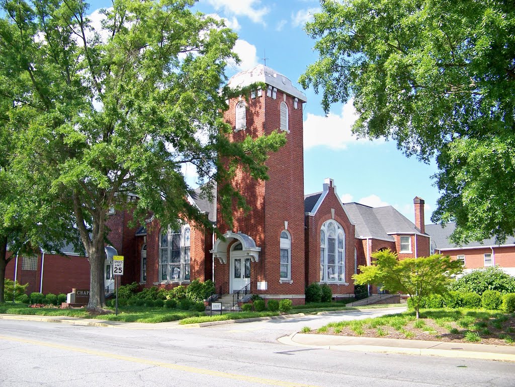


First Baptist Simpsonville
Monument and historic site · National Register of Historic Places · 4.1 mi
Church building in Simpsonville, South Carolina, U.S.A.

Roper Mountain Science Center
Museum · 4.1 mi
Science museum in Greenville, South Carolina


Parks, trails and playgrounds19





GE Vernova Park
Sports field and stadium · 1.8 mi
825 Bridgeway Boulevard, Mauldin
7 more on the map.
Restaurants and cafes167




155 more on the map.
History
Benjamin Griffith was awarded the first land grant in what is now called Mauldin in 1784. The name of Mauldin was given to the town almost accidentally in 1885 thanks to South Carolina's lieutenant governor, W. L. Mauldin. The train station was called "Mauldin" because the lieutenant governor had assisted in getting the Greenville and Laurens Railroad to come through the village. Over time, the entire area took the name of Mauldin.
From the History section of Mauldin, South Carolina on Wikipedia, under CC BY-SA 4.0.
Where to stay11
DoubleTree by Hilton Greenville Woodruff Road
Motel and hotel · 2.9 mi
135 Carolina Point Parkway, Greenville
Staybridge Suites Greenville I-85 Woodruff Road
Motel and hotel · 2.9 mi
31 Market Point Drive, Greenville
Tru by Hilton Greenville Woodruff Road
Motel and hotel · 3.0 mi
122 Carolina Point Parkway, Greenville
Churches and places of worship49
McBee Methodist Church
Church · National Register of Historic Places · 2.9 mi
McBee United Methodist Church
Church · Methodist · 2.9 mi
53 Main Street, Conestee
Mount Zion Presbyterian Church (Sandy Springs, South Carolina)
Church · 4.1 mi
Shopping24
Gas and EV charging26
Schools, colleges and libraries57
W. Jack Greer Mauldin Library Branch
Library · 1.3 mi
800 West Butler Road, Greenville
Healthcare21
Map of Mauldin
250 places. The map loads OpenStreetMap tiles when you open it.
Climate by month
Monthly table
| Month | High | Low | Rain |
|---|---|---|---|
| Jan | 52°F | 30°F | 4.4 in |
| Feb | 56°F | 32°F | 3.5 in |
| Mar | 64°F | 39°F | 4.3 in |
| Apr | 72°F | 47°F | 4.2 in |
| May | 78°F | 56°F | 3.8 in |
| Jun | 84°F | 65°F | 4.4 in |
| Jul | 87°F | 68°F | 4.6 in |
| Aug | 86°F | 68°F | 4.4 in |
| Sep | 80°F | 62°F | 4.0 in |
| Oct | 70°F | 50°F | 3.9 in |
| Nov | 61°F | 39°F | 4.0 in |
| Dec | 54°F | 33°F | 5.1 in |
U.S. Climate Normals 1991-2020 for Greenville (4 mi away), NOAA NCEI.
People and cost of living
American Community Survey 5-year estimates, 2020-2024, U.S. Census Bureau. Estimates have margins of error, larger for small towns.
Disaster history
Greenville County has had 25 federal disaster declarations since 2000, most often for hurricanes.
- 2026-04-07: Severe Winter Storm (Winter Storm)
- 2026-01-23: Severe Winter Storm (Winter Storm)
- 2025-03-23: Table Rock Fire Complex (Fire)
- 2024-09-29: Hurricane Helene (Hurricane)
- 2024-09-26: Hurricane Helene (Tropical Storm)
- 2024-08-05: Hurricane Debby (Tropical Storm)
OpenFEMA disaster declarations summaries.
Getting there and nearby towns
Donaldson Field Airport at SCTAC (GDC) is the nearest airport with scheduled flights listed in OpenStreetMap, 4 miles away.
- Greenville 5 mi northwest, about 8 min by car
- Five Forks 5 mi northeast, about 8 min by car
- Gantt 6 mi west, about 9 min by car
- Fountain Inn 8 mi southeast, about 13 min by car
- Parker 10 mi northwest, about 16 min by car
- Greer 11 mi north, about 18 min by car
- Powdersville 11 mi west, about 18 min by car
- Berea 11 mi northwest, about 18 min by car
- Easley 16 mi west, about 26 min by car
- Anderson 26 mi southwest, about 42 min by car
Drive times are estimates from straight-line distance, not routes.
Local news
Headlines from INDB, the NEMICO news database.
Reviews, tips and questions
Loading what members have shared...
Sources and licences
- NCES EDGE (Public domain): public schools
- NOAA NCEI U.S. Climate Normals 1991-2020 (Public domain): climate by month
- OpenFEMA (Public domain): disaster declarations
- OpenStreetMap contributors (ODbL 1.0): places, airports, map data
- U.S. Census Bureau (Public domain): population, income, housing, education, commute
- Wikidata (CC0 1.0): elevation, founding date, time zone, website, landmarks and historic places
- Wikimedia Commons (see each image): photos
- Wikipedia (CC BY-SA 4.0): overview and history text
Photo credits
- Kmart W Butler Rd Mauldin, SC (8118298498), Mike Kalasnik from Fort Mill, USA, CC BY-SA 2.0
- Publix W Butler Rd Mauldin, SC (8118253732), Mike Kalasnik from Fort Mill, USA, CC BY-SA 2.0
- Kmart W Butler Rd Mauldin, SC (8118299028), Mike Kalasnik from Fort Mill, USA, CC BY-SA 2.0
- Kmart W Butler Rd Mauldin, SC (8118299674), Mike Kalasnik from Fort Mill, USA, CC BY-SA 2.0
- Kmart W Butler Rd Mauldin, SC (8118300224), Mike Kalasnik from Fort Mill, USA, CC BY-SA 2.0
- Kmart W Butler Rd Mauldin, SC (8118300594), Mike Kalasnik from Fort Mill, USA, CC BY-SA 2.0
- ConesteeMill, John Foxe, CC BY-SA 3.0
- Simpsonville Baptist Church - Simpsonville, SC, Upstateherd, CC BY-SA 4.0
- Historic mcbee methodist church, Michael E. Crocker, CC BY-SA 4.0
- C Granville Wyche Home, Bill Fitzpatrick, CC BY-SA 3.0
- Burdette Building, Simpsonville, SC, Upstateherd, CC BY-SA 4.0
- TuttiFruttiFrozenYogurt, PseudoSkull, Public domain
- Shining Stars Tutoring, PseudoSkull, Public domain
- ISS047-E-70937 - View of Earth, Earth Science and Remote Sensing Unit , Lyndon B. Johnson Space Center, Public domain
- ISS047-E-89566 - View of Earth, Earth Science and Remote Sensing Unit , Lyndon B. Johnson Space Center, Public domain
- ISS059-E-104710 - View of Virginia, Earth Science and Remote Sensing Unit, NASA Johnson Space Center, Public domain
- ISS034-E-32328 - View of Earth, Earth Science and Remote Sensing Unit , Lyndon B. Johnson Space Center, Public domain
- ISS047-E-89565 - View of Earth, Earth Science and Remote Sensing Unit , Lyndon B. Johnson Space Center, Public domain
- ISS047-E-67281 - View of Earth, Earth Science and Remote Sensing Unit , Lyndon B. Johnson Space Center, Public domain
- ISS047-E-70938 - View of Earth, Earth Science and Remote Sensing Unit , Lyndon B. Johnson Space Center, Public domain
- ISS047-E-70939 - View of Earth, Earth Science and Remote Sensing Unit , Lyndon B. Johnson Space Center, Public domain
- Eating Cake (2005-09-03), Jason Trommetter, CC BY-SA 2.0
- Spare Tire (30017014), Jason Trommetter from Greenville, United States, CC BY-SA 2.0
- BridgeWay Station, MiamiMogul, CC0
- Awesome Red Roof - panoramio, Tony Crescibene, CC BY-SA 3.0
- Susie & Ed's (28383303035), Nicolas Henderson from Coppell, Texas, CC BY 2.0
- Conestee, South Carolina, Nicolas Henderson from Coppell, Texas, CC BY 2.0
- Reedy River, Conestee, SC (27766867904), Nicolas Henderson from Coppell, Texas, CC BY 2.0
- Wrapped Up (27766870044), Nicolas Henderson from Coppell, Texas, CC BY 2.0
- Conestee Mill (28383308265), Nicolas Henderson from Coppell, Texas, CC BY 2.0
- Puccinia arundinariae 666077781, Chase Harris, CC0
- Golden Strip Career Center, PseudoSkull, Public domain
- U.S. Route 276 in Greenville, Mx. Granger, CC0
- Boxwood Subdivision - panoramio, Tony Crescibene, CC BY-SA 3.0


Page built October 30, 2026. Spotted a mistake? Tell us or suggest a place.