


Mesquite, Nevada
Mesquite is a city of 22,059 people in Clark County, Nevada, founded in 1880.
Why visit Mesquite
Townapedia lists 8 museums and landmarks, 28 parks and trails, 36 places to eat, 15 places to stay and 3 attractions in and around town.
Highlights include Mesquite Stadium 6, Mesquite Community Theatre, Virgin Valley Heritage Museum and Mesquite High School Gymnasium.
July is the warmest month, with average highs of 106°F; December lows average 29°F.
Weather in Mesquite
Forecast from the National Weather Service. Full forecast
About Mesquite
Mesquite is a city located in the northeast corner of Clark County, Nevada, United States adjacent to the Arizona state line and 80 miles (130 km) northeast of Las Vegas on Interstate 15. As of the 2020 census, the city had a population of 20,471. The city is located in the Virgin River valley adjacent to the Virgin Mountains in the northeastern part of the Mojave Desert. It is home to a growing retirement community, as well as several casino resorts and golf courses.
From the Wikipedia article Mesquite, Nevada (this version), under CC BY-SA 4.0.
Things to do3


Museums and landmarks8

Virgin Valley Heritage Museum
Museum · National Register of Historic Places · 3.2 mi
Hospital in Nevada, United States
35 West Mesquite Boulevard, Mesquite
Tu-Sa 10:00-16:00

Mesquite High School Gymnasium
Monument and historic site · National Register of Historic Places · 3.3 mi
High school in Nevada, United States
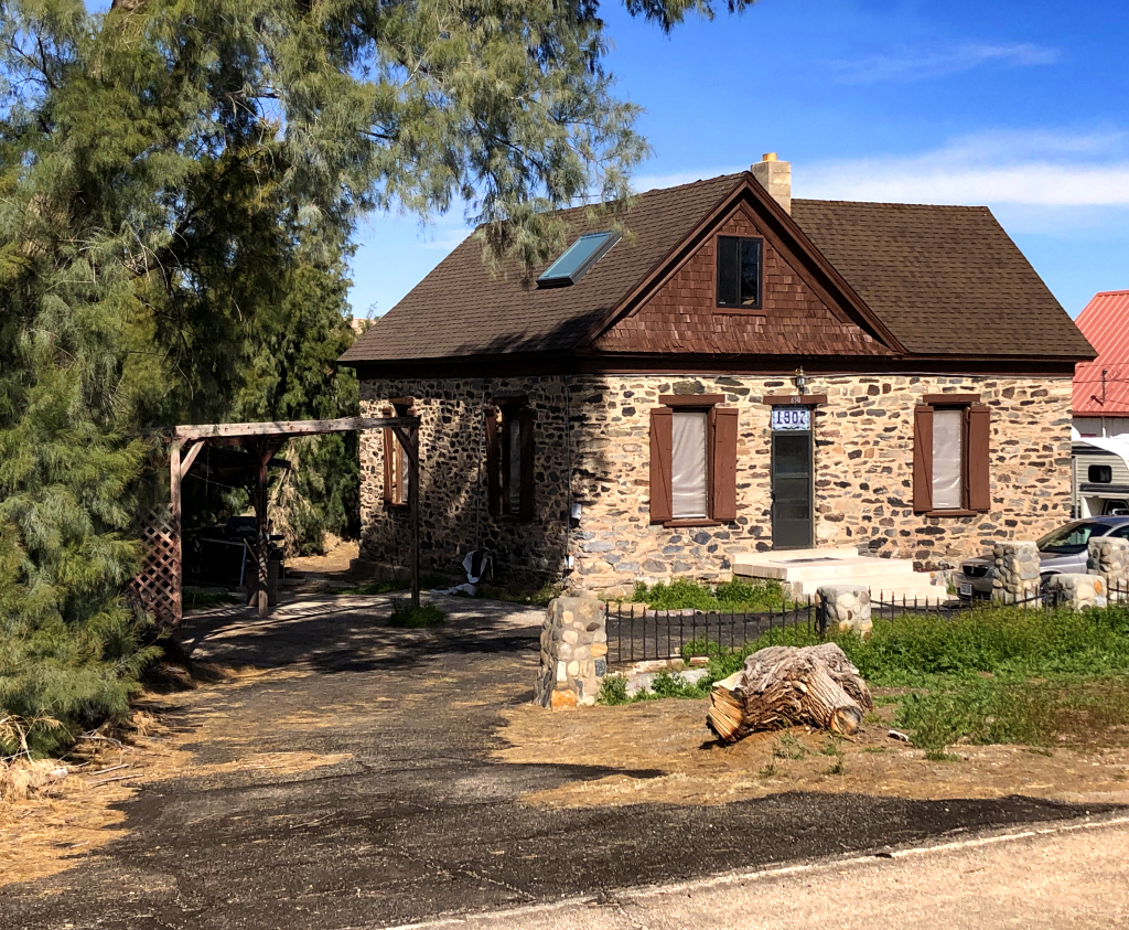


Parley Hunt House
Monument and historic site · National Register of Historic Places · 2.5 mi
Historic home in Bunkerville, Nevada, United States
Thomas Leavitt House
Monument and historic site · National Register of Historic Places · 2.8 mi
Historic house in Nevada, United States
Donkey History Museum
Museum · 2.8 mi
355 West Mesquite Boulevard, Mesquite
Mo off; Tu-Th 10:00-16:00; Fr-Su 09:00-17:00
The Rock House
Monument and historic site · 3.3 mi
110 East First North Street, Mesquite
Parks, trails and playgrounds28


Mesquite Regional Park Trailhead
Park · 0.8 mi
25 North Lower Flat Top Drive, Mesquite
Mo-Su 05:00-22:00
Hunter Sports Park
Park · 3.7 mi
500 East Mesquite Boulevard, Mesquite
sunrise-sunset
16 more on the map.
Restaurants and cafes36


Dutch Bros. Coffee
Cafe · Coffee Shop · 3.4 mi
331 North Sandhill Boulevard, Mesquite
Mo-Th 05:00-22:00; Fr-Sa 05:00-23:00; Su 05:00-22:00

Thai House Restaurant
Restaurant · Thai · 3.5 mi
430 North Sandhill Boulevard
Mo-Sa 11:00-21:00
Los Lupes
Restaurant · Mexican · 3.0 mi
312 West Mesquite Boulevard
Su-Th 09:00-21:00; Fr-Sa 09:00-22:00
Cucina Italiana
Restaurant · Italian · 2.6 mi
471 West Mesquite Boulevard, Mesquite
Mad Mikes Bar and Grill
Restaurant · Pizza, Burger, American · 2.5 mi
551 West Mesquite Boulevard, Mesquite
24 more on the map.
History
Mesquite was settled by Mormon pioneers in 1880, who called it Mesquite Flat. The community was finally established on the third attempt after having been flooded out from the waters of the Virgin River. The name was later shortened to Mesquite, and the city was incorporated 1984. The community was named for the mesquite timber near the original town site. Mesquite, like nearby Bunkerville, had its origins in farming. The Peppermill Mesquite casino, which opened in the 1970s, drove Mesquite's diversified economy. The city incorporated in 1984 and established a master development plan during the early 1990s. In the mid-1990s, more casinos opened. By 2006, Mesquite was one of the fastest-growing small towns in the United States, though the late-2000s recession led to the closure of the Oasis (formerly the Peppermill) casino.
From the History section of Mesquite, Nevada on Wikipedia, under CC BY-SA 4.0.
Where to stay15
Stateline Casino and Hotel
Motel and hotel · 2.6 mi
490 West Mesquite Boulevard, Mesquite
Churches and places of worship4
La Virgen de Guadalupe Catholic Church
Church · Roman Catholic · 3.1 mi
401 Canyon Crest Boulevard, Mesquite
The Church of Jesus Christ of Latter-day Saints
Church · Mormon · 2.8 mi
100 North Arrowhead Lane, Mesquite
Shopping5
Gas and EV charging16
Schools, colleges and libraries10
Healthcare5
Canyonlands Healthcare
Clinic and pharmacy · 3.4 mi
210 North Sandhill Boulevard, Mesquite
Smith's Pharmacy
Clinic and pharmacy · 3.5 mi
350 North Sandhill Boulevard, Mesquite
Map of Mesquite
130 places. The map loads OpenStreetMap tiles when you open it.
Climate by month
Monthly table
| Month | High | Low | Rain |
|---|---|---|---|
| Jan | 60°F | 30°F | 0.8 in |
| Feb | 65°F | 35°F | 0.9 in |
| Mar | 73°F | 40°F | 0.6 in |
| Apr | 81°F | 46°F | 0.3 in |
| May | 90°F | 55°F | 0.1 in |
| Jun | 101°F | 63°F | 0.1 in |
| Jul | 106°F | 71°F | 0.3 in |
| Aug | 104°F | 70°F | 0.7 in |
| Sep | 97°F | 60°F | 0.3 in |
| Oct | 84°F | 48°F | 0.6 in |
| Nov | 69°F | 36°F | 0.5 in |
| Dec | 59°F | 29°F | 0.6 in |
U.S. Climate Normals 1991-2020 for Bunkerville (3 mi away), NOAA NCEI.
People and cost of living
American Community Survey 5-year estimates, 2020-2024, U.S. Census Bureau. Estimates have margins of error, larger for small towns.
Disaster history
Clark County has had 11 federal disaster declarations since 2000, most often for fires.
- 2020-04-04: Covid-19 Pandemic (Biological)
- 2020-03-13: Covid-19 (Biological)
- 2013-07-05: Carpenter 1 Fire (Fire)
- 2010-07-01: Cathedral Fire (Fire)
- 2005-09-13: Hurricane Katrina Evacuation (Hurricane)
- 2005-06-24: Good Springs Fire (Fire)
OpenFEMA disaster declarations summaries.
Getting there and nearby towns
Mesquite Airport (MFH) is the nearest airport with scheduled flights listed in OpenStreetMap, 4 miles away.
- Bunkerville 3 mi south, about 5 min by car
- Scenic 6 mi east, about 10 min by car
- Beaver Dam 12 mi northeast, about 20 min by car
- Moapa Valley 23 mi southwest, about 37 min by car
- Moapa Town 29 mi west, about 47 min by car
- Santa Clara 34 mi northeast, about 55 min by car
- St. George 35 mi northeast, about 57 min by car
- Ivins 35 mi northeast, about 56 min by car
- Washington 41 mi northeast, about 1 h by car
- Hurricane 48 mi northeast, about 1 h 15 min by car
Drive times are estimates from straight-line distance, not routes.
Local news
Headlines from INDB, the NEMICO news database.
Reviews, tips and questions
Loading what members have shared...
Sources and licences
- NCES EDGE (Public domain): public schools
- NOAA NCEI U.S. Climate Normals 1991-2020 (Public domain): climate by month
- OpenFEMA (Public domain): disaster declarations
- OpenStreetMap contributors (ODbL 1.0): places, airports, map data
- U.S. Census Bureau (Public domain): population, income, housing, education, commute
- Wikidata (CC0 1.0): elevation, founding date, time zone, website, landmarks and historic places
- Wikimedia Commons (see each image): photos
- Wikipedia (CC BY-SA 4.0): overview and history text
Photo credits
- Mesquite Nevada 2, Stan Shebs, CC BY-SA 3.0
- Mesquite, Nevada (9179232493), Ken Lund from Reno, Nevada, USA, CC BY-SA 2.0
- Mesquite, Nevada (98447787), Ken Lund from Reno, Nevada, USA, CC BY-SA 2.0
- Mesquite Nevada city hall 1, Stan Shebs, CC BY-SA 3.0
- Mesquite Nevada, vamos a probar suerte - panoramio, picalele, CC BY 3.0
- Annular Solar Eclipse, Mesquite, Nevada (7239346990), Ken Lund from Reno, Nevada, USA, CC BY-SA 2.0
- Annular Solar Eclipse, Mesquite, Nevada (7239346494), Ken Lund from Reno, Nevada, USA, CC BY-SA 2.0
- Memorial in Mesquite, Nevada During Annular Eclipse Twilight (7239346354), Ken Lund from Reno, Nevada, USA, CC BY-SA 2.0
- Projection of Annular Solar Eclipse, Mesquite, Nevada (7239344896), Ken Lund from Reno, Nevada, USA, CC BY-SA 2.0
- Abby with Eclipse Viewing Glasses, Mesquite, Nevada (7239343856), Ken Lund from Reno, Nevada, USA, CC BY-SA 2.0
- Projection of Annular Solar Eclipse, Mesquite, Nevada (7239343614), Ken Lund from Reno, Nevada, USA, CC BY-SA 2.0
- The "Ring of Fire" - Annular Solar Eclipse, Mesquite, Nevada (2) (7239346638), Ken Lund from Reno, Nevada, USA, CC BY-SA 2.0
- Mesquite High School Gymnasium - front view, Cheesyfer, CC BY-SA 3.0
- Mesquite High School Gymnasium, Cheesyfer, CC BY-SA 3.0
- ParleyHuntHouseBunkervilleNevada, RaulJusinto, CC BY-SA 4.0
- Flickr - paul bica - fire in the sky, paul (dex) bica from toronto, canada, CC BY 2.0
- ISS034-E-49492 - View of Earth, Earth Science and Remote Sensing Unit , Lyndon B. Johnson Space Center, Public domain
- ISS007-E-8358 - View of Nevada, Earth Science and Remote Sensing Unit , Lyndon B. Johnson Space Center, Public domain
- ISS034-E-49490 - View of Earth, Earth Science and Remote Sensing Unit , Lyndon B. Johnson Space Center, Public domain
- ISS065-E-28136 - View of Earth, Earth Science and Remote Sensing Unit , Lyndon B. Johnson Space Center, Public domain
- ISS034-E-49491 - View of Earth, Earth Science and Remote Sensing Unit , Lyndon B. Johnson Space Center, Public domain
- A gas station in Nevada (54238495654), Sergiy Galyonkin from Raleigh, USA, CC BY-SA 2.0
- Gas station with a view (54294366480), Sergiy Galyonkin from Raleigh, USA, CC BY-SA 2.0
- Gas station in Nevada (54310715353), Sergiy Galyonkin from Raleigh, USA, CC BY-SA 2.0
- Thomas Leavitt House - street view, Cheesyfer, CC BY-SA 3.0
- Thomas Leavitt House - Early Bunkerville Settler Marker, Cheesyfer, CC BY-SA 3.0
- Thomas Leavitt House - front view, Cheesyfer, CC BY-SA 3.0
- Approaching Las Vegas, Nevada from the Northeast (98447684), Ken Lund from Reno, Nevada, USA, CC BY-SA 2.0
- “all of us have a place in history. mine is clouds.” ―Richard Brautigan ☁️ ⛰ ☁️ (33461157554), anokarina, CC BY-SA 2.0
- Lime Kiln Canyon Road Arizona BLM (29922096425), Tony Webster from Minneapolis, Minnesota, CC BY-SA 2.0
- ISS007-E-8356 - View of Nevada, Earth Science and Remote Sensing Unit , Lyndon B. Johnson Space Center, Public domain
- ISS066-E-20965 - View of Earth, Earth Science and Remote Sensing Unit , Lyndon B. Johnson Space Center, Public domain
- ISS007-E-8357 - View of Nevada, Earth Science and Remote Sensing Unit , Lyndon B. Johnson Space Center, Public domain


Page built October 30, 2026. Spotted a mistake? Tell us or suggest a place.