
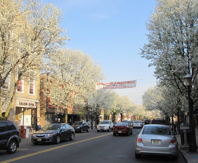


Metuchen, New Jersey
Metuchen is a borough of 15,144 people in Middlesex County, New Jersey.
Why visit Metuchen
Townapedia lists 15 museums and landmarks, 31 parks and trails, 100 places to eat, 7 places to stay and 4 attractions in and around town.
Highlights include AMC Dine-In Menlo Park 12, Stephen J. Capestro Theatre, Metuchen Post Office and Ayers-Allen House.
July is the warmest month, with average highs of 88°F; January lows average 24°F, and about 21 inches of snow fall in a normal year.
Weather in Metuchen
Forecast from the National Weather Service. Full forecast
About Metuchen
Metuchen is a suburban borough in Middlesex County in the U.S. state of New Jersey. The borough is a commuter town of New York City, located in the heart of the Raritan Valley region within the New York Metropolitan area. The borough, along with Edison (which completely surrounds Metuchen), is a regional commercial hub for Central New Jersey. The borough is 6 miles (9.7 km) northeast of New Brunswick, 17 miles (27 km) southwest of Newark, 20 miles (32 km) southwest of Jersey City, and 22 miles (35 km) southwest of Manhattan.
From the Wikipedia article Metuchen, New Jersey (this version), under CC BY-SA 4.0.
Things to do4

Stephen J. Capestro Theatre
Cinema and theater · 1.2 mi
Outdoor theater in Edison, New Jersey
Museums and landmarks15
Metuchen Post Office
Monument and historic site · National Register of Historic Places
Historic building in Metuchen, New Jersey
360 Main Street, Metuchen
Mo-Fr 08:00-19:00; Sa 09:00-16:00; Su off

Ayers-Allen House
Monument and historic site · National Register of Historic Places
Historic home in Metuchen, New Jersey

Benjamin Shotwell House
Monument and historic site · National Register of Historic Places · 2.2 mi
Historic house in New Jersey, United States

Laing House of Plainfield Plantation
Monument and historic site · National Register of Historic Places · 3.1 mi
Historic house in New Jersey, United States

Mary Wilkins Freeman House
Monument and historic site · National Register of Historic Places · 0.4 mi
Historic house in Middlesex County, New Jersey

Metuchen Borough Hall
Monument and historic site · National Register of Historic Places
City hall of Metuchen, New Jersey

Middlesex Avenue–Woodwild Park Historic District
Monument and historic site · National Register of Historic Places
Historic district in Metuchen, New Jersey


Roosevelt Hospital
Monument and historic site · National Register of Historic Places · 1.4 mi
Historic building in Edison, New Jersey

Thomas Alva Edison Memorial Tower and Museum
Museum · National Register of Historic Places · 1.9 mi
3 more on the map.
Parks, trails and playgrounds31


Supercharged Entertainment
Sports field and stadium · 1.6 mi
987 US Route 1 South, Edison
Mo-Th 11:00-24:00, Fr 11:00-01:00, Sa 09:00-01:00, Su 09:00-23:00


19 more on the map.
Restaurants and cafes100


Anthony's Coal Fired Pizza
Restaurant · Pizza, Wings · 1.6 mi
80 Parsonage Road, Edison
Mo-Th,Su 11:00-22:00; Fr-Sa 11:00-23:00

Applebee's
Diner · American · 1.3 mi
1045 US Route 1 South, Edison
Mo-Th,Su 11:00-24:00, Fr-Sa 11:00-01:00

Baked Bouquet
Bakery · Cupcake · 1.5 mi
180 Lafayette Avenue, Edison
Tu-Fr 09:00-17:00; Sa-Su 10:00-16:00
Benihana
Restaurant · Japanese, Teppanyaki, Steak · 1.6 mi
60 Parsonage Road, Edison
Mo-Th,Su 11:30-22:00; Fr-Sa 11:30-23:00
Brooklyn Boys Pizza & Deli
Restaurant · Pizza · 1.3 mi
9 Lincoln Highway, Edison
Mo-Th 10:00-21:30; Fr-Sa 10:00-22:00
Chuck E. Cheese
Restaurant · Pizza · 1.6 mi
1120 US Route 1 North, Edison
Mo-Th 10:00-21:00; Fr 11:00-22:00; Sa 10:00-22:00; Su 11:00-21:00
Civile Cucina Italiana
Restaurant · Italian · 0.7 mi
154 Main Street, Metuchen
Tu-Th,Su 17:00-21:00; Fr-Sa 17:00-22:00
IHOP
Restaurant · Breakfast, Pancake · 1.6 mi
50 Parsonage Road, Edison
Mo-Sa 07:00-22:00; Su 07:00-20:00
88 more on the map.
History
The earliest residents of the area were the Raritan people of the Lenape Native Americans, who lived in the area and travelled through it to the shore. In 1646, Chief Matouchin was part of a group that included 1,200 warriors.
Until 1870, what is now Metuchen was part of Woodbridge Township. The settlers in the western part of the township developed their own separate identity, because they were so far removed from the main settlement of Woodbridge. The name "Metuchen" first appeared in 1688/1689, and its name was derived from the name of a Native American chief, whose name was variously spelled as Matouchin or Matochshegan. In 1701, an overseer of roads was appointed for "Metuchen district". In 1705, Main Street was laid out at the same time as the road from Metuchen to Woodbridge, which one source calls a "reworking of the original road".
Sometime between 1717 and 1730, a meeting house was constructed for weekday meetings conducted by the pastor of the Woodbridge Presbyterian Church. In 1756, Metuchen Presbyterians succeeded in forming their own congregation, attesting to their growing numbers. In 1770, the congregations merged, with Metuchen getting 2/5 of the pastor's services and Woodbridge 3/5; by 1772, Metuchen had grown sufficiently to warrant half of his time. In 1793, the two churches again separated.
From the History section of Metuchen, New Jersey on Wikipedia, under CC BY-SA 4.0.
Where to stay7
Churches and places of worship14
Shopping20
Gas and EV charging12
Schools, colleges and libraries54
Academy For Urban Leadership Charter School
School · 4.8 mi
612 Amboy Ave, Perth Amboy
Benjamin Franklin Elementary School
School · 2.7 mi
2485 Woodbridge Avenue, Edison
Cresthaven Academy Charter School
School · 5.7 mi
530 West 7Th Street, Plainfield
Healthcare10
Map of Metuchen
250 places. The map loads OpenStreetMap tiles when you open it.
Climate by month
Monthly table
| Month | High | Low | Rain | Snow |
|---|---|---|---|---|
| Jan | 41°F | 24°F | 3.8 in | 5.1 in |
| Feb | 44°F | 26°F | 3.1 in | 8.3 in |
| Mar | 53°F | 32°F | 4.3 in | 5.3 in |
| Apr | 66°F | 42°F | 3.6 in | 0.1 in |
| May | 75°F | 51°F | 4.0 in | 0.0 in |
| Jun | 84°F | 60°F | 4.3 in | 0.0 in |
| Jul | 88°F | 66°F | 5.3 in | 0.0 in |
| Aug | 86°F | 64°F | 4.0 in | 0.0 in |
| Sep | 79°F | 58°F | 4.3 in | 0.0 in |
| Oct | 66°F | 46°F | 4.3 in | 0.0 in |
| Nov | 56°F | 36°F | 3.5 in | 0.2 in |
| Dec | 46°F | 29°F | 4.2 in | 2.4 in |
U.S. Climate Normals 1991-2020 for Plainfield Hcn (5 mi away), NOAA NCEI.
People and cost of living
American Community Survey 5-year estimates, 2020-2024, U.S. Census Bureau. Estimates have margins of error, larger for small towns.
Disaster history
Middlesex County has had 17 federal disaster declarations since 2000, most often for hurricanes.
- 2021-09-05: Remnants Of Hurricane Ida (Hurricane)
- 2021-09-02: Remnants Of Hurricane Ida (Hurricane)
- 2020-03-25: Covid-19 Pandemic (Biological)
- 2020-03-13: Covid-19 (Biological)
- 2016-03-14: Severe Winter Storm And Snowstorm (Severe Storm)
- 2012-10-30: Hurricane Sandy (Hurricane)
OpenFEMA disaster declarations summaries.
Getting there and nearby towns
Linden Airport (LDJ) is the nearest airport with scheduled flights listed in OpenStreetMap, 8 miles away.
- Fords 3 mi east, about 4 min by car
- Highland Park 4 mi southwest, about 7 min by car
- East Franklin 7 mi southwest, about 11 min by car
- Bound Brook 9 mi west, about 15 min by car
- Elizabeth 12 mi northeast, about 20 min by car
- Franklin Park 12 mi southwest, about 19 min by car
- Manville 12 mi west, about 19 min by car
- Martinsville 12 mi west, about 19 min by car
- Blackwells Mills 13 mi west, about 21 min by car
- Newark 16 mi northeast, about 26 min by car
Drive times are estimates from straight-line distance, not routes.
Local news
Headlines from INDB, the NEMICO news database.
Reviews, tips and questions
Loading what members have shared...
Sources and licences
- NCES EDGE (Public domain): public schools
- NOAA NCEI U.S. Climate Normals 1991-2020 (Public domain): climate by month
- OpenFEMA (Public domain): disaster declarations
- OpenStreetMap contributors (ODbL 1.0): places, airports, map data
- U.S. Census Bureau (Public domain): population, income, housing, education, commute
- Wikidata (CC0 1.0): elevation, founding date, time zone, website, landmarks and historic places
- Wikimedia Commons (see each image): photos
- Wikipedia (CC BY-SA 4.0): overview and history text
Photo credits
- Metuchen1, Metuchenpic, CC0
- MetuchenPostOffice, KForce, CC BY-SA 3.0
- 300 Middlesex Avenue, Metuchen, NJ - Corbin House, Zeete, CC BY-SA 4.0
- Benjamin Shotwell House, Edison, NJ, Zeete, CC BY-SA 3.0
- LAING HOUSE OF PLAINFIELD PLANTATION, MIDDLESEX COUNTY, Jerrye & Roy Klotz, MD, CC BY-SA 4.0
- Roosevelt Hospital, Edison, NJ - north view, Zeete, CC BY-SA 3.0
- MetuchenNJ MaryWilkinsFreemanHouse, Magicpiano, CC BY-SA 4.0
- Ayers-Allen House, Metuchen, NJ, Zeete, CC BY-SA 3.0
Page built October 30, 2026. Spotted a mistake? Tell us or suggest a place.