

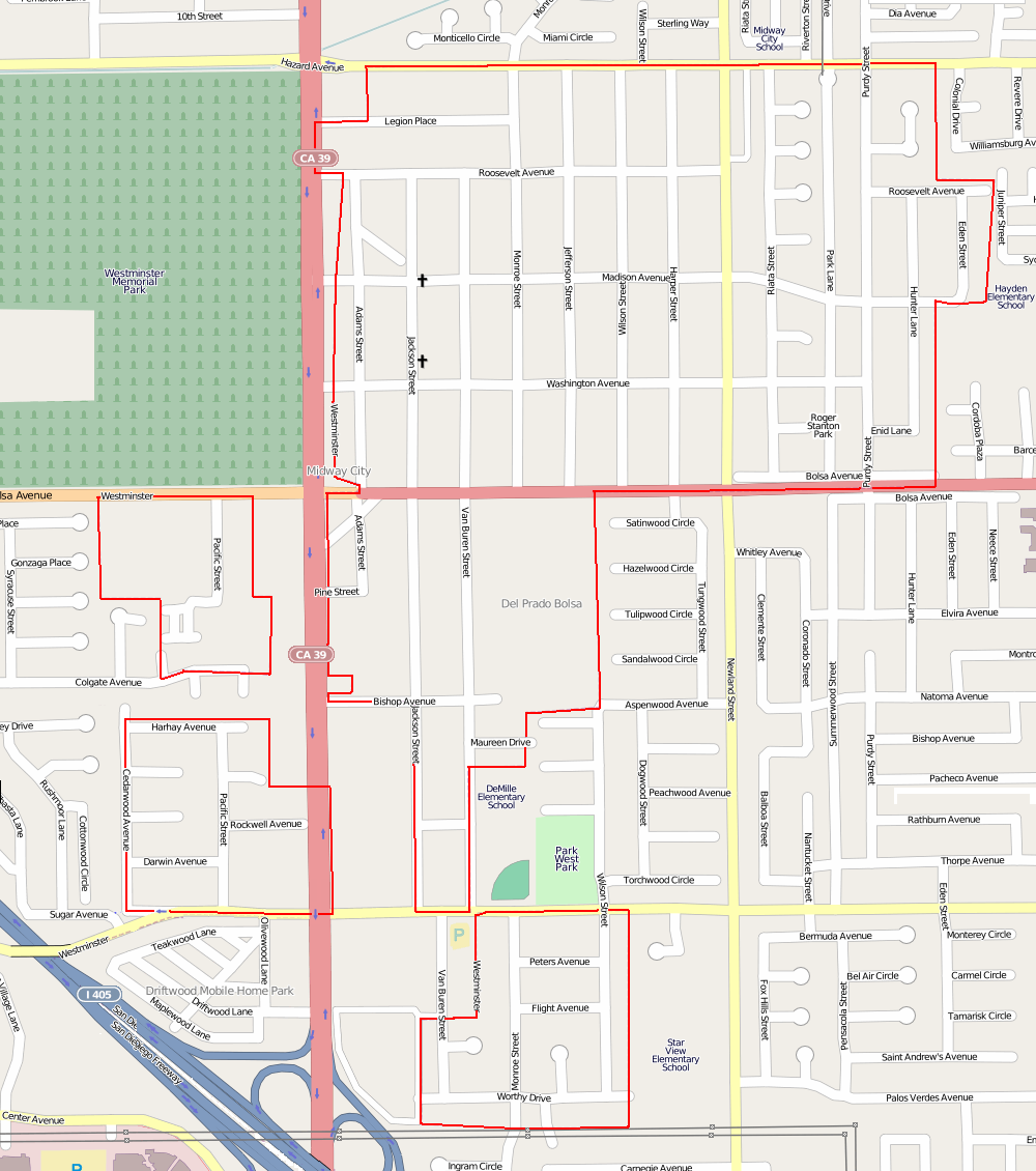


Midway City, California
Midway City is a community of 7,999 people in Orange County, California.
Why visit Midway City
Townapedia lists 1 museum or landmark, 16 parks and trails, 101 places to eat, 6 places to stay and 4 attractions in and around town.
Highlights include Century Huntington Beach and XD, Apollos University, Mile Square Regional Park and College Park.
August is the warmest month, with average highs of 85°F; December lows average 48°F.
Weather in Midway City
Forecast from the National Weather Service. Full forecast
About Midway City
Midway City is an unincorporated community and census-designated place (CDP) that forms part of the county land controlled by Orange County, California. The only area in Orange County that incorporates its chamber of commerce and homeowners association to act in concert like a city council, the area mostly is surrounded by Westminster with Huntington Beach bordering it on the southwest. Midway City was so named because it is horizontally midway between Seal Beach, to the west, and Santa Ana, to the east. The 2020 census listed the population as 8,825.
From the Wikipedia article Midway City, California (this version), under CC BY-SA 4.0.
Things to do4


Rose Center Theater
Cinema and theater · 0.8 mi
Theater within the Westminster Rose Center in Westminster, California, United States
Museums and landmarks1

Parks, trails and playgrounds16


Mile Square Regional Park
Park · 2.7 mi
Park in Fountain Valley, California, US

4 more on the map.
Restaurants and cafes101

Burattino Brick Oven Pizza
Restaurant · Pizza · 1.3 mi
7451 Edinger Avenue, Huntington Beach
Su-Th 10:00-21:00
Islands Restaurant
Restaurant · Burger, American, Beer · 1.1 mi
7861 Edinger Avenue, Huntington Beach
Su-Mo 11:00-21:00; Fr-Sa 11:00-22:00

Lollicup Fresh Westminster
Cafe · Coffee Shop, Bubble Tea, Tea · 1.4 mi
9550 Bolsa Avenue, Westminster
Mo-Su 10:00-22:00
Morena's Mexican Cuisine
Restaurant · Mexican · 1.4 mi
7402 Edinger Avenue, Huntington Beach
Tu,Fr,Sa 11:00-22:00; Mo,We,Th 11:00-21:00; Su 10:00-21:00

Final Touch Bakery
Bakery · 0.9 mi
15056 Weststate Street, Westminster
Mo-Tu 09:00-16:00, We-Sa 09:00-17:00, Su 09:00-15:00


Chè Góc Phố
Cafe · Vietnamese, Dessert · 1.2 mi
9433 Bolsa Avenue, Westminster
Mo-We, Fr 11:30-21:00; Sa-Su 11:30-22:00
89 more on the map.
Where to stay6
Comfort Inn & Suites Huntington Beach
Motel and hotel · 1.3 mi
16301 Beach Boulevard, Huntington Beach
SpringHill Suites Huntington Beach Orange County
Motel and hotel · 1.1 mi
7872 Edinger Avenue, Huntington Beach
Super 8 Westminster CA/Huntington Beach Area
Motel and hotel · 0.7 mi
15559 Beach Boulevard, Westminster
The Hotel Huntington Beach
Motel and hotel · 1.0 mi
7667 Center Avenue, Huntington Beach
Churches and places of worship21
Hội Thánh Tin Lành Việt Nam;Vietnamese Alliance Church
Church · Christian And Missionary Alliance
Al-Noor Foundation
Place of worship · Sunni · 1.3 mi
14522 Goldenwest Street, Westminster
Shopping34
Gas and EV charging10
Schools, colleges and libraries60
Courreges (Roch) Elementary
School · 3.4 mi
18313 Santa Carlotta, Fountain Valley
Cox (James H.) Elementary
School · 3.7 mi
17615 Los Jardines East, Fountain Valley
Healthcare9
Value Scripts Pharmacy
Clinic and pharmacy · 1.2 mi
9433 Bolsa Avenue, Westminster
Map of Midway City
250 places. The map loads OpenStreetMap tiles when you open it.
Climate by month
Monthly table
| Month | High | Low | Rain | Snow |
|---|---|---|---|---|
| Jan | 69°F | 49°F | 2.9 in | 0.0 in |
| Feb | 69°F | 50°F | 3.2 in | 0.0 in |
| Mar | 71°F | 52°F | 1.7 in | 0.0 in |
| Apr | 73°F | 54°F | 0.8 in | 0.0 in |
| May | 75°F | 58°F | 0.3 in | 0.0 in |
| Jun | 78°F | 61°F | 0.1 in | 0.0 in |
| Jul | 82°F | 65°F | 0.0 in | 0.0 in |
| Aug | 85°F | 65°F | 0.0 in | 0.0 in |
| Sep | 84°F | 64°F | 0.1 in | 0.0 in |
| Oct | 79°F | 59°F | 0.5 in | 0.0 in |
| Nov | 74°F | 53°F | 0.8 in | 0.0 in |
| Dec | 68°F | 48°F | 2.2 in | 0.0 in |
U.S. Climate Normals 1991-2020 for Santa Ana Fire Stn (7 mi away), NOAA NCEI.
People and cost of living
American Community Survey 5-year estimates, 2020-2024, U.S. Census Bureau. Estimates have margins of error, larger for small towns.
Disaster history
Orange County has had 26 federal disaster declarations since 2000, most often for fires.
- 2026-10-16: Norte Fire (Fire)
- 2026-05-25: Chemical Release (Chemical)
- 2023-03-10: Severe Winter Storms, Flooding, Landslides, And Mudslides (Flood)
- 2023-01-09: Severe Winter Storms, Flooding, And Mudslides (Flood)
- 2022-05-12: Coastal Fire (Fire)
- 2020-12-03: Bond Fire (Fire)
OpenFEMA disaster declarations summaries.
Getting there and nearby towns
John Wayne Airport (SNA) is the nearest airport with scheduled flights listed in OpenStreetMap, 8 miles away.
- Westminster 1 mi northwest, about 1 min by car
- Garden Grove 3 mi northeast, about 4 min by car
- Fountain Valley 3 mi southeast, about 5 min by car
- Huntington Beach 3 mi south, about 6 min by car
- Stanton 4 mi north, about 6 min by car
- Seal Beach 5 mi west, about 8 min by car
- Santa Ana 6 mi east, about 9 min by car
- Cypress 6 mi northwest, about 10 min by car
- Los Alamitos 6 mi northwest, about 9 min by car
- Costa Mesa 7 mi southeast, about 11 min by car
Drive times are estimates from straight-line distance, not routes.
Local news
Headlines from INDB, the NEMICO news database.
Reviews, tips and questions
Loading what members have shared...
Sources and licences
- NCES EDGE (Public domain): public schools
- NOAA NCEI U.S. Climate Normals 1991-2020 (Public domain): climate by month
- OpenFEMA (Public domain): disaster declarations
- OpenStreetMap contributors (ODbL 1.0): places, airports, map data
- U.S. Census Bureau (Public domain): population, income, housing, education, commute
- Wikidata (CC0 1.0): elevation, founding date, time zone, website, landmarks and historic places
- Wikimedia Commons (see each image): photos
- Wikipedia (CC BY-SA 4.0): overview and history text
Photo credits
- Midway City sq mi area, Self, Public domain
- Midway City CA boundary, Self, CC BY-SA 2.0
- Warner Avenue Baptist Church, RabidTuberculosis, CC0
- Mile Square Park, Dns0702, CC BY-SA 3.0
- Westminster, CA, USA - panoramio (1), peter boy12qq12, CC BY 3.0
- Westminster, CA, USA - panoramio, peter boy12qq12, CC BY 3.0
- Westminster, CA, USA - panoramio (10), peter boy12qq12, CC BY 3.0
- Westminster, CA, USA - panoramio (2), peter boy12qq12, CC BY 3.0
- Westminster, CA, USA - panoramio (7), peter boy12qq12, CC BY 3.0
- Westminster, CA, USA - panoramio (6), peter boy12qq12, CC BY 3.0
- Westminster, CA, USA - panoramio (5), peter boy12qq12, CC BY 3.0
- Westminster, CA, USA - panoramio (9), peter boy12qq12, CC BY 3.0
- Westminster, CA, USA - panoramio (3), peter boy12qq12, CC BY 3.0
- Westminster, CA, USA - panoramio (4), peter boy12qq12, CC BY 3.0
- Westminster, CA, USA - panoramio (8), peter boy12qq12, CC BY 3.0
- Westminster, CA, USA - panoramio (13), peter boy12qq12, CC BY 3.0
- Westminster, CA, USA - panoramio (12), peter boy12qq12, CC BY 3.0
- Westminster, CA, USA - panoramio (14), peter boy12qq12, CC BY 3.0
- Westminster, CA, USA - panoramio (15), peter boy12qq12, CC BY 3.0
- Westminster, CA, USA - panoramio (11), peter boy12qq12, CC BY 3.0
- Westminster City Limit, Bolsa Ave at Eden St., Aug. 1962, Orange County Archives, CC BY 2.0
- Vehicle Warning at Westminster Memorial Park and Mortuary in English and Vietnamese, Sdogg7159, CC BY-SA 4.0
- Garden of Peaceful Eternity, Westminster Memorial Park, Orange County Archives, CC BY 2.0
- Bentley (51103605553), Tracie Hall from Orange County, us, CC BY-SA 2.0
- Panoramic View of Bolsa Ave & Westminster Memorial Park and Mortuary, Sdogg7159, CC BY-SA 4.0
- Tenerife Memorial, Westminster Memorial Park, Jeremy Nguyen, CC BY-SA 4.0
- Bus stop, Magnolia St. above Bolsa Ave, Orange County Archives, CC BY 2.0
- Vietnamese Boat People Monument (2009), Westminster Memorial Park, Orange County Archives, CC BY 2.0
- Vietnamese Boat People Memorial, Westminster, CA, February 13, 2026, Jeremy Nguyen, CC BY-SA 4.0
- Vietnam War memorial, Westminster, Orange County Archives, CC BY 2.0
- Vietnam War Memorial, Little Saigon, Westminster, California, February 13, 2026, Jeremy Nguyen, CC BY-SA 4.0
- Northern start terminus of Hoover St in Westminster, Sdogg7159, CC BY-SA 4.0
- Statue of Trần Hưng Đạo, Westminster, CA, Jeremy Nguyen, CC BY-SA 4.0
- Surgery Photo Dr. Nima Abbassi, Dr. Nima Abbassi, CC BY-SA 4.0
- Vietnam War Memorial (5871538123), InSapphoWeTrust from Los Angeles, California, USA, CC BY-SA 2.0
- Vietnam War Memorial (5871538063), InSapphoWeTrust from Los Angeles, California, USA, CC BY-SA 2.0
- Vietnam War Memorial (5872096262), InSapphoWeTrust from Los Angeles, California, USA, CC BY-SA 2.0
- Bolsa Ave., Aug 1962, Orange County Archives, CC BY 2.0
- Beach Blvd exit, Eric Polk, CC BY-SA 4.0


Page built October 30, 2026. Spotted a mistake? Tell us or suggest a place.