


Milford, Pennsylvania
Milford is a borough of 1,198 people in Pike County, Pennsylvania, founded in 1796.
Why visit Milford
Townapedia lists 16 museums and landmarks, 10 parks and trails, 20 places to eat, 4 places to stay and 6 attractions in and around town.
Highlights include Milford–Montague Toll Bridge, Raymondskill Falls, Callahan House and Foster-Armstrong House.
July is the warmest month, with average highs of 82°F; January lows average 16°F, and about 41 inches of snow fall in a normal year.
Weather in Milford
Forecast from the National Weather Service. Full forecast
About Milford
Milford is a borough that is located in Pike County, Pennsylvania, United States, and the county seat. Its population was 1,103 at the time of the 2020 census.
From the Wikipedia article Milford, Pennsylvania (this version), under CC BY-SA 4.0.
Things to do6

Milford–Montague Toll Bridge
Bridge · 1.1 mi
Bridge in Montague Township, New Jersey

Raymondskill Falls
Waterfall · 3.2 mi
Series of waterfalls in Pennsylvania, United States


Museums and landmarks16

Callahan House
Monument and historic site · National Register of Historic Places · 0.5 mi
Historic home in Milford, Dingman Township, Pike County, Pennsylvania, United States of America

Foster-Armstrong House
Museum · National Register of Historic Places · 1.2 mi
Historic house in Montague Township, New Jersey

Grey Towers National Historic Site
Monument and historic site · National Register of Historic Places · 1.1 mi
Home of Gifford Pinchot, founder of U.S. Forest Service, outside Milford, Pennsylvania

Forester's Hall
Monument and historic site · National Register of Historic Places
Historic building in Milford, Pike County, Pennsylvania
Hotel Fauchere and Annex
Monument and historic site · National Register of Historic Places
House in Pennsylvania, United States of America

Jervis Gordon Grist Mill Historic District
Monument and historic site · National Register of Historic Places · 0.5 mi
Historic district in Pennsylvania, United States
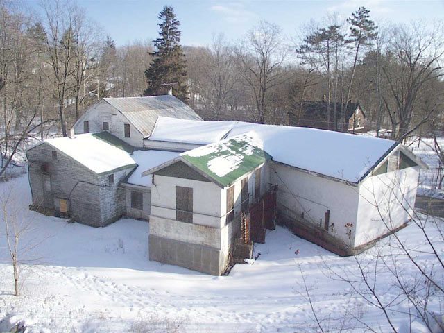


Metz Ice Plant
Monument and historic site · National Register of Historic Places · 0.5 mi
Historic ice plant in Milford, Pennsylvania
Pike County Courthouse
Monument and historic site · National Register of Historic Places
Courthouse in Pennsylvania, United States

4 more on the map.
Parks, trails and playgrounds10


Restaurants and cafes20

Dimmick Inn and Steakhouse
Restaurant · Steak House
101 East Harford Street, Milford
Su-Tu 11:30-20:00; We-Sa 11:30-21:00
John's of Arthur Avenue
Restaurant · Pizza · 0.4 mi
115 7th Street, Milford
Su-Th 11:00-20:00; Fr,Sa 11:00-21:00
Chang Mao Chinese Food
Restaurant · Chinese
206 West Harford Street, Milford


8 more on the map.
History
The area along the Delaware River where the community of Milford is located had long been settled by the Lenape, an Algonquian-speaking indigenous tribe that lived in the mid-Atlantic coastal areas at the time of European colonization. The English also called them the Delaware, after the river they named for colonial leader Thomas West, 3rd Baron De La Warr, the Delaware.
Milford was founded in 1796 by Judge John Biddis, one of Pennsylvania's first four circuit judges. He named the settlement after his ancestral home in Wales.
Milford has a large number of buildings of historical significance, many constructed in the nineteenth century and early twentieth centuries. Some are listed on the National Register of Historic Places, while numerous others are included in the Milford Historic District. Of the 655 buildings in the district, 400 of them have been deemed to be historically significant. The district is characterized by a variety of Late Victorian architecture.
The Grey Towers National Historic Site, the ancestral home of Gifford Pinchot, noted conservationist, two-time governor of Pennsylvania, and first head of the U.S. Forest Service, is located in Milford. It was designed by architect Richard Morris Hunt has been designated a National Historic Site.
From the History section of Milford, Pennsylvania on Wikipedia, under CC BY-SA 4.0.
Where to stay4
Churches and places of worship5
Milford United Methodist Church
Church · United Methodist
206 East Ann Street, Milford
Shopping19
Gas and EV charging4
Schools, colleges and libraries4
Healthcare3
Tri-State Pregnancy Center
Clinic and pharmacy · 0.9 mi
105 Wheatfield Drive, Milford
Upper Delaware Valley Cancer Center
Clinic and pharmacy · 1.3 mi
113 Pocono Drive, Milford
Map of Milford
91 places. The map loads OpenStreetMap tiles when you open it.
Climate by month
Monthly table
| Month | High | Low | Rain | Snow |
|---|---|---|---|---|
| Jan | 34°F | 16°F | 3.1 in | 11.6 in |
| Feb | 37°F | 17°F | 2.9 in | 9.7 in |
| Mar | 46°F | 25°F | 3.9 in | 6.8 in |
| Apr | 59°F | 34°F | 3.9 in | 1.9 in |
| May | 70°F | 45°F | 3.3 in | 0.0 in |
| Jun | 78°F | 55°F | 5.4 in | 0.0 in |
| Jul | 82°F | 58°F | 3.7 in | 0.0 in |
| Aug | 80°F | 57°F | 4.4 in | 0.0 in |
| Sep | 74°F | 50°F | 4.7 in | 0.0 in |
| Oct | 62°F | 39°F | 4.7 in | 0.0 in |
| Nov | 50°F | 29°F | 3.3 in | 0.8 in |
| Dec | 40°F | 23°F | 4.0 in | 10.0 in |
U.S. Climate Normals 1991-2020 for Matamoras (6 mi away), NOAA NCEI.
People and cost of living
American Community Survey 5-year estimates, 2020-2024, U.S. Census Bureau. Estimates have margins of error, larger for small towns.
Disaster history
Pike County has had 11 federal disaster declarations since 2000, most often for hurricanes.
- 2020-03-30: Covid-19 Pandemic (Biological)
- 2020-03-13: Covid-19 (Biological)
- 2013-01-10: Hurricane Sandy (Hurricane)
- 2012-10-29: Hurricane Sandy (Hurricane)
- 2011-09-03: Hurricane Irene (Hurricane)
- 2011-08-29: Hurricane Irene (Hurricane)
OpenFEMA disaster declarations summaries.
Getting there and nearby towns
Sullivan County International Airport (MSV) is the nearest airport with scheduled flights listed in OpenStreetMap, 26 miles away.
- Port Jervis 7 mi northeast, about 11 min by car
- Sparrow Bush 7 mi northeast, about 12 min by car
- Birchwood Lakes 8 mi southwest, about 12 min by car
- Sussex 13 mi southeast, about 21 min by car
- Crandon Lakes 14 mi south, about 23 min by car
- Hamburg 17 mi southeast, about 27 min by car
- Vernon Valley 17 mi east, about 28 min by car
- Otisville 17 mi northeast, about 27 min by car
- Franklin 18 mi southeast, about 30 min by car
- Newton 19 mi south, about 31 min by car
Drive times are estimates from straight-line distance, not routes.
Local news
Headlines from INDB, the NEMICO news database.
Reviews, tips and questions
Loading what members have shared...
Sources and licences
- NCES EDGE (Public domain): public schools
- NOAA NCEI U.S. Climate Normals 1991-2020 (Public domain): climate by month
- OpenFEMA (Public domain): disaster declarations
- OpenStreetMap contributors (ODbL 1.0): places, airports, map data
- U.S. Census Bureau (Public domain): population, income, housing, education, commute
- Wikidata (CC0 1.0): elevation, founding date, time zone, website, landmarks and historic places
- Wikimedia Commons (see each image): photos
- Wikipedia (CC BY-SA 4.0): overview and history text
Photo credits
- Milford Bird's-Eye View crop, Nicholas ; cropped by Beyond My Ken ( talk ) 23:22, 27 September 2011 (UTC), CC BY 2.0
- Tom Quick Inn front Milford PA, Beyond My Ken, CC BY-SA 4.0
- Old Stone Courthouse Milford PA, Beyond My Ken, CC BY-SA 4.0
- Tom Quick Inn Milford PA, Beyond My Ken, CC BY-SA 4.0
- Pike County Courthouse Milford PA, Beyond My Ken, CC BY-SA 4.0
- Hotel Fauchere front Milford PA, Beyond My Ken, CC BY-SA 4.0
- Hotel Fauchere Milford PA, Beyond My Ken, CC BY-SA 4.0
- Judge John Biddis Memorial Milford PA, Beyond My Ken, CC BY-SA 4.0
- 18 East Catherine Street Milford PA, Beyond My Ken, CC BY-SA 4.0
- Milford, PA police department headquarters, July 2024, Mr. Matté (if there is an issue with this image, contact me using this image's Commons talk page , my Commons user talk page , or my English Wikipedia user talk page ; I'll know about it a lot faster), CC BY-SA 4.0
- Milford Theatre Milford PA, Beyond My Ken, CC BY-SA 4.0
- Milford Theatre Milford PA 2, Beyond My Ken, CC BY-SA 4.0
- Milford Theater Detail, Kether83, CC BY-SA 4.0
- Milford Theater Overview, Kether83, CC BY-SA 4.0
- First Presbyterian Church Milford PA, Beyond My Ken, CC BY-SA 4.0
- Church of the Good Shepherd and St. John the Evangelist Milford PA, Beyond My Ken, CC BY-SA 4.0
- The Columns Milford PA, Beyond My Ken, CC BY-SA 4.0
- Public Library Milford PA, Beyond My Ken, CC BY-SA 4.0
- Forest Hall Milford PA, Beyond My Ken, CC BY-SA 4.0
- Old Schoolhouse Building Milford PA, Beyond My Ken, CC BY-SA 4.0
- Harrington House Milford PA, Beyond My Ken, CC BY-SA 4.0
- Milford Twp., Pike Co., PA municipal building, July 2024, Mr. Matté (if there is an issue with this image, contact me using this image's Commons talk page , my Commons user talk page , or my English Wikipedia user talk page ; I'll know about it a lot faster), CC BY-SA 4.0
- Foster-Armstrong House, Montague Township, NJ, Zeete, CC BY-SA 4.0
- Callahan House DWG NPS, National Park Service, Public domain
- Grey Towers National Historic Site rear view, Jason Quinn, Public domain
- Jervis Gordon grist mill gears and wheels 2, Ammodramus, CC0
- Metz Ice Plant DWG NPS, National Park Service, Public domain
- Milford-Montague Toll Bridge over Delaware River (30545669096), Tony Webster from Minneapolis, Minnesota, CC BY-SA 2.0
- Long exposure of Raymondskill Falls PA 2025-09-29 14-27-40, G. Edward Johnson, CC BY 4.0
- Flickr - Nicholas T - Bird's-Eye View, Nicholas A. Tonelli from Pennsylvania, USA, CC BY 2.0
- Arrowhead ~ Home of Virginia Kidd & James Blish (3223096261), StillRiverside, CC BY 2.0
- Grey Towers Built by Gifford Pinchot, BJLAT, CC BY-SA 4.0
- 2021-09-09 09 38 17 View south along U.S. Route 209 just north of U.S. Route 206 in Dingman Township, Pike County, Pennsylvania, Famartin, CC BY-SA 4.0
- 2021-09-09 09 37 05 View north along U.S. Route 209 just north of U.S. Route 206 in Dingman Township, Pike County, Pennsylvania, Famartin, CC BY-SA 4.0
- 2024-09-20 12 15 17 View north along U.S. Route 209 just north of U.S. Route 206 in Dingman Township, Pike County, Pennsylvania, Famartin, CC BY-SA 4.0
- 2021-09-09 09 32 17 View north along U.S. Route 209 just south of U.S. Route 206 in Dingman Township, Pike County, Pennsylvania, Famartin, CC BY-SA 4.0
- 2024-09-20 12 13 14 View north along U.S. Route 206 just south of U.S. Route 209 in Dingman Township, Pike County, Pennsylvania, Famartin, CC BY-SA 4.0
- 2021-09-09 09 35 06 View north along U.S. Route 206 just south of U.S. Route 209 in Dingman Township, Pike County, Pennsylvania, Famartin, CC BY-SA 4.0
- Grey Towers National Historic Site (20230812-FS-TR-001), Forest Service Photography, Public domain
- Grey Towers walkway approach, Beyond My Ken, CC BY-SA 4.0


Page built October 30, 2026. Spotted a mistake? Tell us or suggest a place.