


Mobridge, South Dakota
Mobridge is a city of 2,932 people in Walworth County, South Dakota, founded in 1906.
Why visit Mobridge
Townapedia lists 6 museums and landmarks, 2 parks and trails, 9 places to eat, 5 places to stay and 2 attractions in and around town.
Highlights include Pheasant Drive-In, Mac Theatre, A. H. Brown Public Library and Brown Palace Hotel.
July is the warmest month, with average highs of 87°F; January lows average 6°F, and about 31 inches of snow fall in a normal year.
Weather in Mobridge
Forecast from the National Weather Service. Full forecast
About Mobridge
Mobridge, also known as Kȟowákataŋ Otȟúŋwahe (Lakota: Kȟowákataŋ Otȟúŋwahe; lit. "Over-the-River Town"), is a city in Walworth County, South Dakota, United States. The population was 3,261 as of the 2020 census.
From the Wikipedia article Mobridge, South Dakota (this version), under CC BY-SA 4.0.
Things to do2

Museums and landmarks6

A. H. Brown Public Library
Monument and historic site · National Register of Historic Places
United States historic place

Brown Palace Hotel
Monument and historic site · National Register of Historic Places · 0.4 mi
Hotel in Mobridge, South Dakota
Brown-Evans House
Monument and historic site · National Register of Historic Places
House in Mobridge, South Dakota
Mobridge Masonic Temple
Monument and historic site · National Register of Historic Places
Masonic temple in South Dakota, United States of America
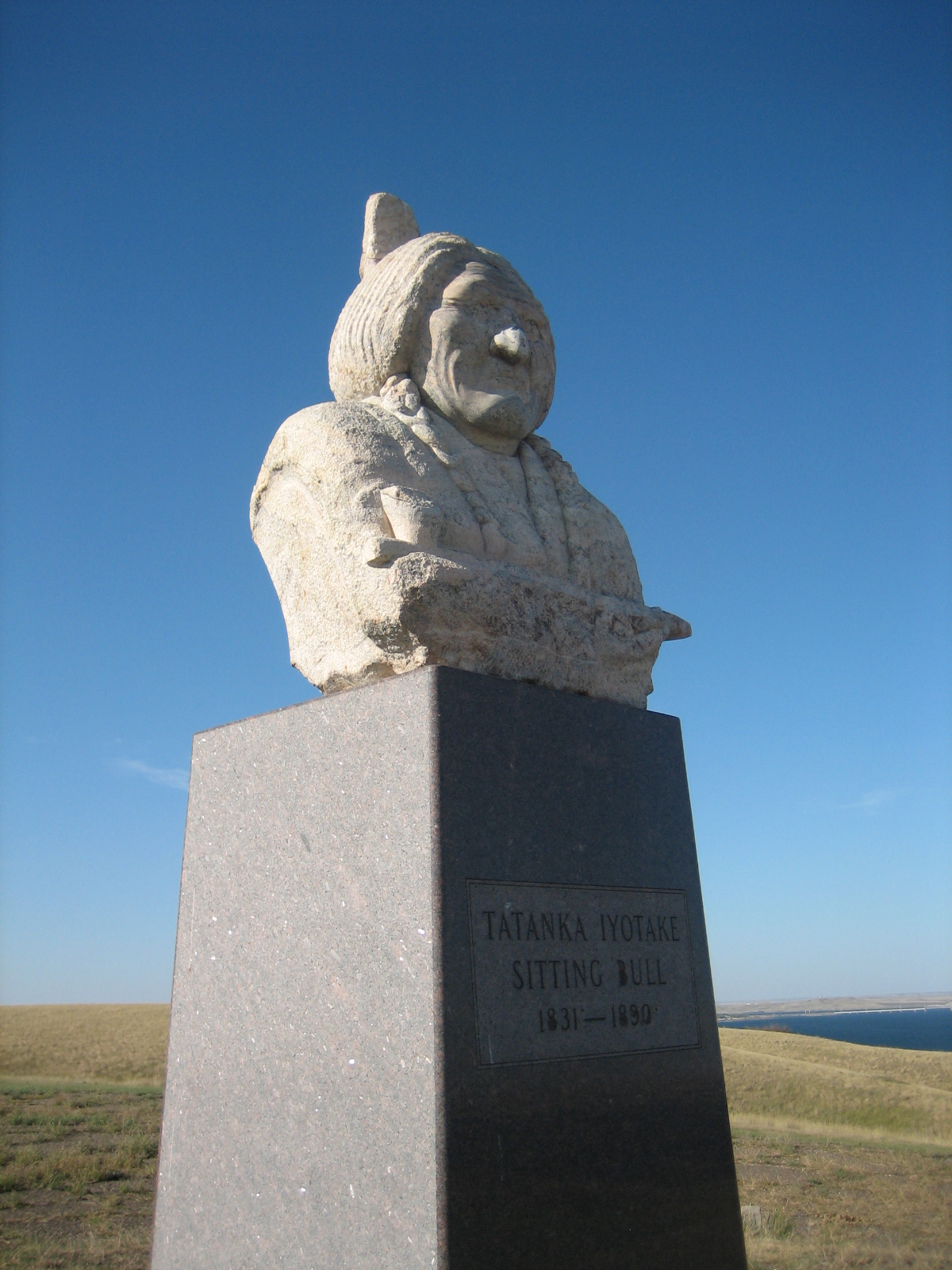
Sitting Bull Monument
Monument and historic site · National Register of Historic Places · 2.9 mi

The Klein Museum
Museum · 1.0 mi
1820 West Grand Crossing, Mobridge
Mo-Fr 09:00-12:00, 13:00-17:00; Sa-Su 13:00-16:00; Oct 16-Apr 30 off
Parks, trails and playgrounds2


Restaurants and cafes9






History
Located in territory that had long been occupied by the Lakota Sioux, Mobridge was founded by European Americans in 1906 following construction of the Chicago, Milwaukee, St. Paul and Pacific Railroad through here. The town was named Mobridge for its railroad designation, a contracted form of Missouri Bridge, after the original railroad bridge over the Missouri River. The bridge was demolished by the Corps of Engineers in the early 1960s and replaced by a taller bridge due to the construction of the Oahe Dam.
There are disputed claims that some or all of chief Sitting Bull's remains were moved by his surviving relatives and the Dakota Memorial Association on April 8, 1953 from Fort Yates, North Dakota, where he had been killed and buried, to Mobridge, which was near his birthplace. The Mobridge burial site is marked by a monument consisting of his bust on a granite pedestal; it overlooks the Missouri River. It was dedicated by the Dakota Memorial Association on April 11, 1953.
The Brown Palace Hotel in Mobridge is listed on the U.S. National Register of Historic Places. Artist Oscar Howe (Yanktonai Dakota) painted a mural for the town's auditorium. The Mobridge Masonic Temple was built in Egyptian Revival style in 1923.
From the History section of Mobridge, South Dakota on Wikipedia, under CC BY-SA 4.0.
Where to stay5
Churches and places of worship7
United Congregational Church
Church · Protestant · 0.4 mi
1001 6th Avenue West, Mobridge
Shopping2
Gas and EV charging3
Schools, colleges and libraries9
Healthcare2
Map of Mobridge
47 places. The map loads OpenStreetMap tiles when you open it.
Climate by month
Monthly table
| Month | High | Low | Rain | Snow |
|---|---|---|---|---|
| Jan | 27°F | 6°F | 0.4 in | 6.3 in |
| Feb | 32°F | 11°F | 0.7 in | 6.4 in |
| Mar | 45°F | 22°F | 0.7 in | 4.1 in |
| Apr | 59°F | 33°F | 1.6 in | 3.2 in |
| May | 70°F | 45°F | 2.9 in | 0.0 in |
| Jun | 80°F | 56°F | 3.1 in | 0.0 in |
| Jul | 87°F | 62°F | 2.3 in | 0.0 in |
| Aug | 86°F | 60°F | 2.0 in | 0.0 in |
| Sep | 76°F | 50°F | 1.5 in | 0.0 in |
| Oct | 60°F | 36°F | 1.8 in | 1.7 in |
| Nov | 44°F | 23°F | 0.4 in | 3.6 in |
| Dec | 32°F | 12°F | 0.5 in | 5.7 in |
U.S. Climate Normals 1991-2020 for Mobridge Muni Ap (1 mi away), NOAA NCEI.
People and cost of living
American Community Survey 5-year estimates, 2020-2024, U.S. Census Bureau. Estimates have margins of error, larger for small towns.
Disaster history
Walworth County has had 6 federal disaster declarations since 2000, most often for biologicals.
- 2020-04-05: Covid-19 Pandemic (Biological)
- 2020-03-13: Covid-19 (Biological)
- 2019-09-23: Severe Storms And Flooding (Flood)
- 2019-06-07: Severe Winter Storm, Snowstorm, And Flooding (Flood)
- 2010-03-10: Severe Winter Storm (Severe Storm)
- 2005-09-10: Hurricane Katrina Evacuation (Coastal Storm)
OpenFEMA disaster declarations summaries.
Getting there and nearby towns
Mobridge Municipal Airport (MBG) is the nearest airport with scheduled flights listed in OpenStreetMap, 1 miles away.
- Selby 20 mi east, about 32 min by car
- McLaughlin 26 mi northwest, about 42 min by car
- Herreid 27 mi northeast, about 43 min by car
- Timber Lake 32 mi west, about 51 min by car
- Bowdle 38 mi east, about 1 h by car
- Hoven 38 mi southeast, about 1 h by car
- Eureka 42 mi east, about 1 h 15 min by car
- Gettysburg 44 mi southeast, about 1 h 15 min by car
- North Eagle Butte 53 mi southwest, about 1 h 30 min by car
- Eagle Butte 54 mi southwest, about 1 h 30 min by car
Drive times are estimates from straight-line distance, not routes.
Local news
Headlines from INDB, the NEMICO news database.
Reviews, tips and questions
Loading what members have shared...
Sources and licences
- NCES EDGE (Public domain): public schools
- NOAA NCEI U.S. Climate Normals 1991-2020 (Public domain): climate by month
- OpenFEMA (Public domain): disaster declarations
- OpenStreetMap contributors (ODbL 1.0): places, airports, map data
- U.S. Census Bureau (Public domain): population, income, housing, education, commute
- Wikidata (CC0 1.0): elevation, founding date, time zone, website, landmarks and historic places
- Wikimedia Commons (see each image): photos
- Wikipedia (CC BY-SA 4.0): overview and history text
Photo credits
- Mobridge Masonic Temple 20160630, Tonymlarsen, CC BY-SA 4.0
- House in Mobridge, decked out for 4th of July (51331229223), Lars Plougmann from United States, CC BY-SA 2.0
- Norwegian Lutheran Church at Mobridge, S. D. (19491376483), Nasjonalbiblioteket from Norway, No restrictions
- Mobridge Disc Golf Course (5068908875), Argyleist, CC BY 2.0
- A fun fair behind the Mobridge rodeo (51331963172), Lars Plougmann from United States, CC BY-SA 2.0
- Mobridge banner, Lars Plougmann from United States, CC BY-SA 2.0
- Pastel sunset in Mobridge, South Dakota (51333417644), Lars Plougmann from United States, CC BY-SA 2.0
- Mobridge, SD 57601, USA - panoramio (2), Eric Friedebach, CC BY 3.0
- Mobridge, SD 57601, USA - panoramio, Eric Friedebach, CC BY 3.0
- Mobridge, SD 57601, USA - panoramio (5), Eric Friedebach, CC BY 3.0
- Mobridge, SD 57601, USA - panoramio (3), Eric Friedebach, CC BY 3.0
- Mobridge, SD 57601, USA - panoramio (1), Eric Friedebach, CC BY 3.0
- Mobridge, SD 57601, USA - panoramio (6), Eric Friedebach, CC BY 3.0
- Mobridge, SD 57601, USA - panoramio (4), Eric Friedebach, CC BY 3.0
- A.H. BROWN PUBLIC LIBRARY, JERRYE & ROY KLOTZ MD, CC BY-SA 3.0
- Sitting Bull Monument, Malchow, Public domain
- Water Tender CAFS demo, Hustvedt, CC BY-SA 3.0
- PZL M18B Dropping Water, Hustvedt, CC BY-SA 3.0


Page built October 30, 2026. Spotted a mistake? Tell us or suggest a place.