


Montpelier, Vermont
Montpelier is a city of 8,014 people in Washington County, Vermont, founded in 1787.
Why visit Montpelier
Townapedia lists 14 museums and landmarks, 11 parks and trails, 46 places to eat, 5 places to stay and 7 attractions in and around town.
Highlights include Community College of Vermont, Union Institute & University, Montpelier Historic District and National Clothespin Factory.
July is the warmest month, with average highs of 82°F; January lows average 7°F.
Weather in Montpelier
Forecast from the National Weather Service. Full forecast
About Montpelier
Montpelier is the capital city of the U.S. state of Vermont and the county seat of Washington County. The site of Vermont's state government, it is the least populous state capital in the United States. As of the 2020 census, the population was 8,074, with a daytime population growth of about 21,000 due to the large number of jobs within city limits. The Vermont College of Fine Arts is located in the municipality.
From the Wikipedia article Montpelier, Vermont (this version), under CC BY-SA 4.0.
Things to do7

Community College of Vermont
School · 1.0 mi
American educational institution
Union Institute & University
School · 0.8 mi
Research university in Cincinnati, Ohio



Museums and landmarks14

Montpelier Historic District
Monument and historic site · National Register of Historic Places · 0.4 mi
Historic district in Vermont, USA

National Clothespin Factory
Monument and historic site · National Register of Historic Places · 1.0 mi
Building in Vermont, United States
3 Granite Street, Montpelier

Athenwood and the Thomas W. Wood Studio
Monument and historic site · National Register of Historic Places · 0.8 mi
Historic house in Vermont, United States
Center Road Culvert
Bridge · National Register of Historic Places · 2.8 mi
Historic stone culvert on Center Road at Mallory Brook in East Montpelier, Vermont
Chauncey B. Leonard House
Monument and historic site · National Register of Historic Places · 3.9 mi
In Berlin, Vermont, listed on the NRHP in Washington County

College Hall
Monument and historic site · National Register of Historic Places · 0.8 mi
Central building of the campus of the Vermont College of Fine Arts in Montpelier, U.S. state of Vermont

East Village Meetinghouse
Monument and historic site · National Register of Historic Places · 4.2 mi
Building in East Montpelier, Vermont, United States

Parley Davis House
Monument and historic site · National Register of Historic Places · 2.4 mi
Building in Vermont, United States
Union Meetinghouse
Monument and historic site · National Register of Historic Places · 2.5 mi
Meetinghouse in East Montpelier, Vermont

Vermont Granite Museum
Museum · National Register of Historic Places · 4.5 mi
Granite industry museum
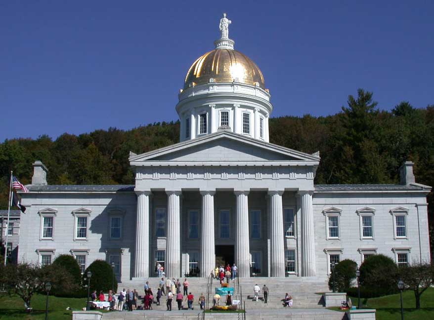
Vermont State House
Monument and historic site · National Register of Historic Places · 0.5 mi
State capitol building of the U.S. state of Vermont

2 more on the map.
Parks, trails and playgrounds11


Hubbard Park
Park
Public park in Montpelier, Washington County, Vermont, United States of America

Central Vermont Memorial Civic Center
Sports field and stadium · 2.3 mi
268 Gallison Hill Road, Montpelier



Union Elementary Playground
Playground · 0.5 mi
Upper playground for older children
Restaurants and cafes46

Café Noa
Cafe · Coffee, Sandwich, Breakfast · 0.8 mi
A sunny cafe serving breakfast and lunch with coffee, tea, and mango lassi.
8 Putnam Street
Mo-Su 07:00-15:00

Bear Naked Growler
Restaurant · Grill · 1.3 mi
186 River Street, Montpelier
Mo-Th 14:00-20:00; Fr-Sa 14:00-21:00; Su 14:00-19:00
China Moon Buffet
Restaurant · Chinese · 2.8 mi
1400 US-302, Barre
Mo-Th 10:30-21:30; Fr,Sa 10:30-22:00; Su 11:00-21:30
Namaste Indian Nepali Kitchen LLp
Restaurant · Indian · 0.4 mi
100 Main Street, Montpelier
Tu-Su 11:00-21:00
Wayside Restaurant & Bakery
Restaurant · American, Diner · 2.3 mi
1873 U.S. Route 302, Montpelier
Mo-Su 07:00-21:00
34 more on the map.
History
The meadows and flats of the Winooski River were well known among natives for their corn-raising capacities. The natural site of Montpelier made it a favorite residence for the natives who first inhabited the land. The level plain of nearly two hundred acres of the rich farmland, sheltered from winds by the surrounding valley made the area comparatively warm and comfortable. Its position near the confluence of many streams allowed for favorable hunting, fishing, and trading. Native mounds, tombstones, and other memorials of aboriginal life and death were found in Montpelier, or in the vicinity, by the first settlers, and traces of some of them still remain.
Between 1600 and 1800, European settlers began to arrive in the region. Soon after, war, disease, and dispersal virtually destroyed the Native American settlements. However, evidence suggests some Native Americans remained in the area as late as the mid-1800s.
From the History section of Montpelier, Vermont on Wikipedia, under CC BY-SA 4.0.
Where to stay5
Econo Lodge Montpelier
Motel and hotel · 1.1 mi
101 Northfield Street, Montpelier
Churches and places of worship12
Christ Episcopal Church
Church · Episcopal · 0.5 mi
64 State Street, Montpelier
St. Augustine Catholic Church
Church · Catholic · 0.6 mi
18 Barre Street, Montpelier
First Church of Christ Scientist
Church · Christ Scientist · 0.7 mi
145 State Street, Montpelier
Shopping19
Gas and EV charging12
Schools, colleges and libraries12
East Montpelier Elementary School
School · 4.0 mi
665 Vincent Flats Road, East Montpelier
Healthcare2
Map of Montpelier
140 places. The map loads OpenStreetMap tiles when you open it.
Climate by month
Monthly table
| Month | High | Low | Rain |
|---|---|---|---|
| Jan | 28°F | 7°F | 2.8 in |
| Feb | 31°F | 9°F | 2.4 in |
| Mar | 40°F | 18°F | 2.6 in |
| Apr | 53°F | 32°F | 3.3 in |
| May | 67°F | 44°F | 4.4 in |
| Jun | 76°F | 54°F | 4.4 in |
| Jul | 82°F | 59°F | 4.6 in |
| Aug | 80°F | 57°F | 3.9 in |
| Sep | 73°F | 50°F | 3.1 in |
| Oct | 58°F | 38°F | 3.7 in |
| Nov | 45°F | 28°F | 2.9 in |
| Dec | 32°F | 17°F | 3.3 in |
U.S. Climate Normals 1991-2020 for Montpelier 2 (2 mi away), NOAA NCEI.
People and cost of living
American Community Survey 5-year estimates, 2020-2024, U.S. Census Bureau. Estimates have margins of error, larger for small towns.
Disaster history
Washington County has had 22 federal disaster declarations since 2000, most often for severe storms.
- 2024-08-20: Severe Storm, Flooding, Landslides, And Mudslides (Severe Storm)
- 2024-08-08: Tropical Depression Debby (Tropical Storm)
- 2023-07-14: Severe Storms, Flooding, Landslides, And Mudslides (Flood)
- 2023-07-10: Flooding (Flood)
- 2023-03-20: Severe Storm And Flooding (Severe Storm)
- 2021-08-22: Tropical Storm Henri (Hurricane)
OpenFEMA disaster declarations summaries.
Getting there and nearby towns
Edward F Knapp State Airport (MPV) is the nearest airport with scheduled flights listed in OpenStreetMap, 4 miles away.
- Barre 6 mi southeast, about 9 min by car
- East Barre 10 mi southeast, about 16 min by car
- Hardwick 19 mi northeast, about 30 min by car
- Morrisville 20 mi north, about 32 min by car
- Johnson 26 mi north, about 42 min by car
- Jericho 26 mi northwest, about 42 min by car
- Bristol 27 mi west, about 44 min by car
- Woodsville 28 mi east, about 46 min by car
- Essex Junction 31 mi northwest, about 50 min by car
- South Burlington 32 mi west, about 52 min by car
Drive times are estimates from straight-line distance, not routes.
Local news
Headlines from INDB, the NEMICO news database.
Reviews, tips and questions
Loading what members have shared...
Sources and licences
- NCES EDGE (Public domain): public schools
- NOAA NCEI U.S. Climate Normals 1991-2020 (Public domain): climate by month
- OpenFEMA (Public domain): disaster declarations
- OpenStreetMap contributors (ODbL 1.0): places, airports, map data
- U.S. Census Bureau (Public domain): population, income, housing, education, commute
- Wikidata (CC0 1.0): elevation, founding date, time zone, website, landmarks and historic places
- Wikimedia Commons (see each image): photos
- Wikipedia (CC BY-SA 4.0): overview and history text
Photo credits
- Vermont State House, Fall 2015, Bob P. B., CC BY 2.0
- NatlClothespin, Mfwills, CC BY-SA 3.0
- State Street Montpelier 5, AlexiusHoratius, CC BY-SA 3.0
- BerlinVT ChaunceyBLeonardHouse, Magicpiano, CC BY-SA 3.0
- EastMontpelierVT UnionMeetinghouse, Magicpiano, CC BY-SA 3.0
- Vermont College--College Hall, Sbjohnson, Public domain
- EastMontpelierVT EastVillageMeetinghouse, Magicpiano, CC BY-SA 3.0
- EastMontpelierVT ParleyDavisHouse, Magicpiano, CC BY-SA 3.0
- Vermont Granite Museum in Barre, Kenneth C. Zirkel, CC BY 4.0
- Vermont State House front, The original uploader was Decumanus at English Wikipedia ., CC BY-SA 3.0
- Christ Church, Episcopal, Montpelier VT, John Phelan, CC BY-SA 3.0
- MontpelierVT HubbardParkTower 20170813 (35783516913), Niranjan Arminius, CC BY-SA 2.0

Page built October 30, 2026. Spotted a mistake? Tell us or suggest a place.